August 3, 2026 Monday Tropical Update
Hints of Atlantic basin activity picking up in the Main Development Region next week as tropical waves finally escape the Saharan Dust over warm ocean waters
August 2026 was the warmest August in the 132-year national record (1895–2026), at 75.6°F against a 1991–2020 normal of 73.1°F (+2.5°F).
August 2026 was the 22nd-driest August in the 132-year national record (1895–2026), at 2.3in against a 1991–2020 normal of 2.7in (-0.4in).
NOAA/NCEI Climate at a Glance, contiguous United States. This is the observed record for the month, not a score of anything said in this piece — the forecast ledger begins 2026-08-17 and cannot reach earlier posts.


Building Weather Trader is underway — archive + real-time weather forecast markets. It assembles the last 10-15 years of my private sector experience and expertise.
Extreme Fire Danger —> air quality alerts for ongoing fires and smoke across Washington and Oregon with more variable upper-level and near surface winds allow the plumes to drift westward toward the coast.
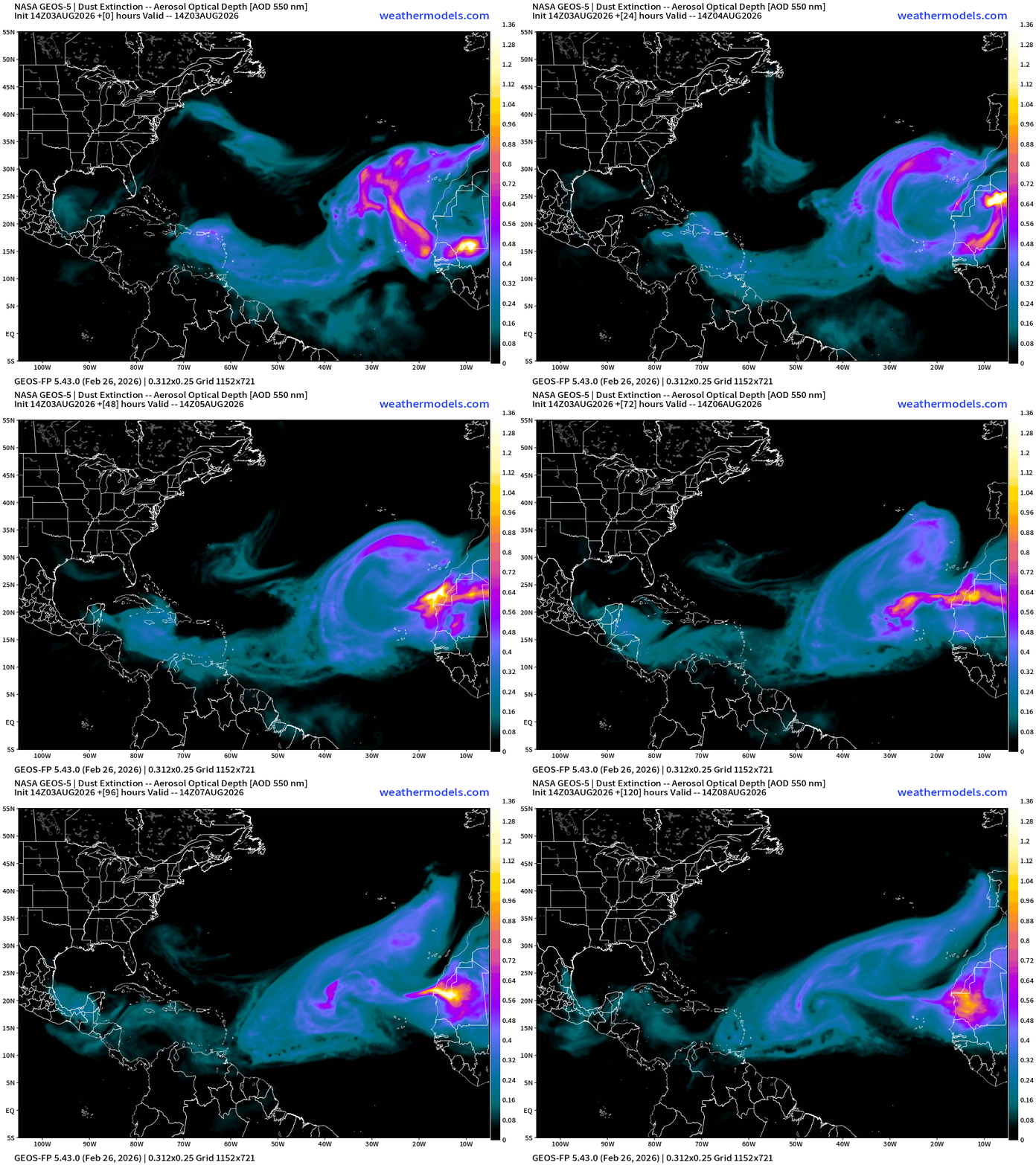
Huge plumes of Saharan desert dust still coming off the African continent to squelch and suppress tropical convection. The Atlantic basin remains dead. This part of the puzzle is less related to El Niño and is a typical SAL + dust inhibitor that usually decreases by mid-August.
But as part of El Niño, the tropical waves head westward in the Main Development Region (MDR), and encounter strong wind shear and interact with upper-level troughs = complete buzzkill for storm formation — at least until they can reach the Eastern Pacific or even the Central Pacific (like Dolphin, which was probably an African Easterly Wave, too) .
Seeing some signs of a brief window of more favorable conditions in the MDR into next week, but still very weak signals.
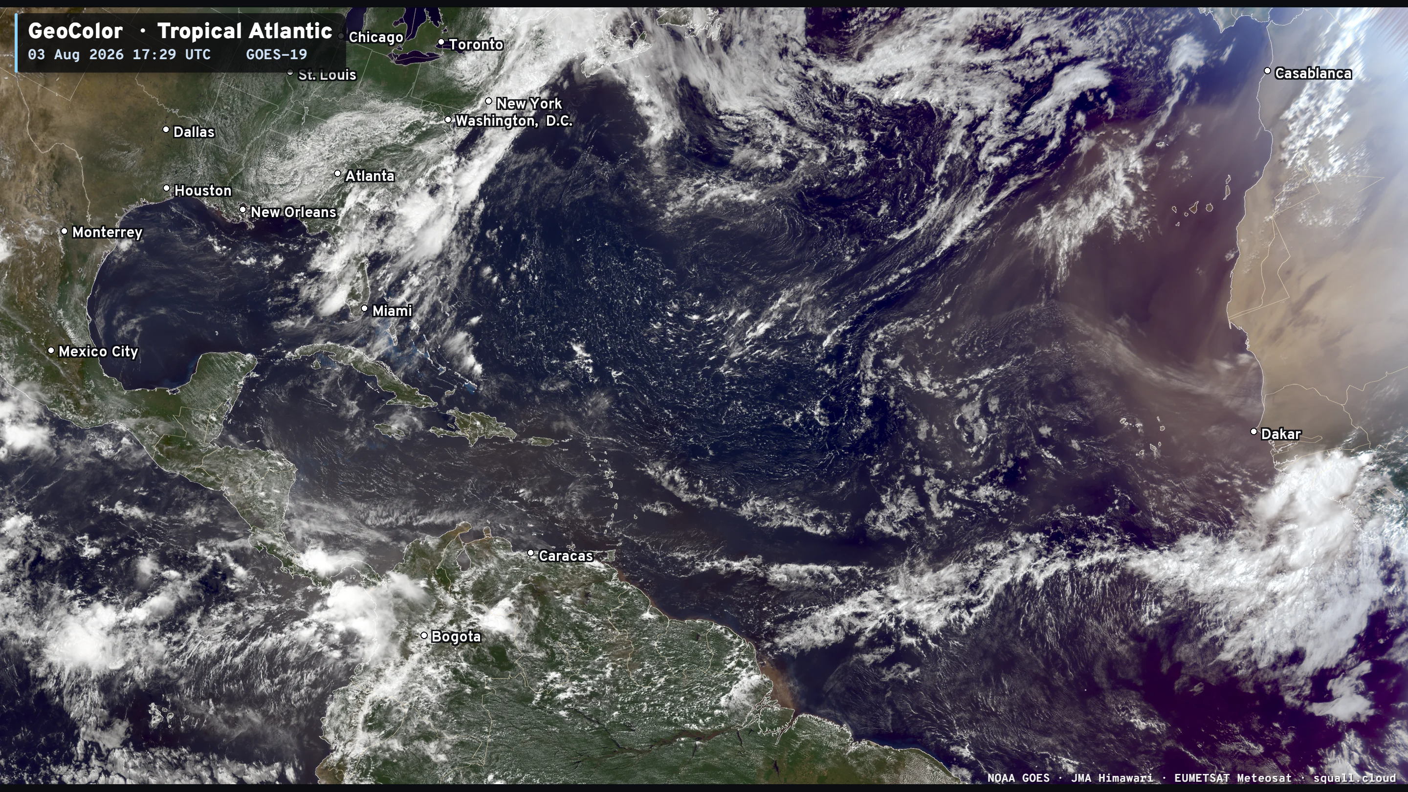
CONUS Water Vapor — Strong Mid-Level Trough cutting through Texas into the Southeast
Eastern Pacific: No activity for the next 7-days —> typical for the EPAC as the basin typically bursts with activity
Typhoon Dolphin (12W) is close to major hurricane strength and has evolved this time from the large tractor tire eye to a smaller more compact one with tighter inner-core.
Quite unusual to see a large eye typhoon transition into a smaller one! I’d put intensity on satellite near T 6.0 —> 115 knots, so on an upswing again over warm ocean waters.
North America Precipitable Water Next 6-days
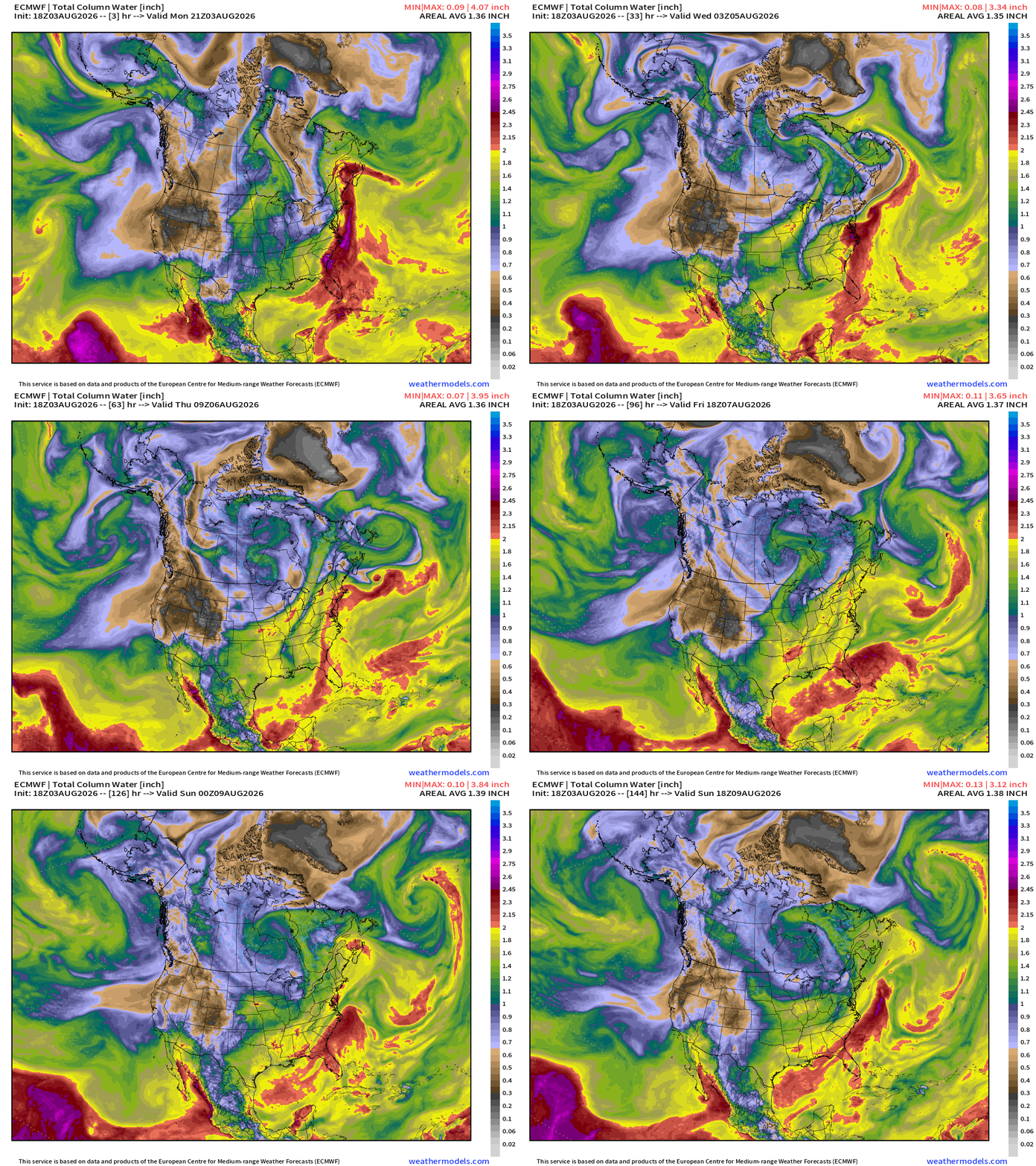
A tropical disturbance approaches the eastern coast of Florida later in the week with plenty of tropical moisture. Maybe something to monitor aside from uptick in rainfall.
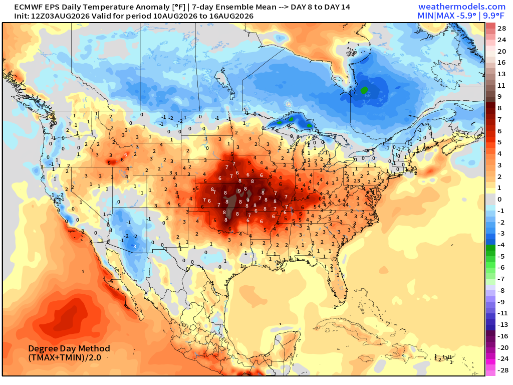
East of the Rockies will tranistion to more northerly flow — dry and cooler out of Canada. That’s anti-heat dome for the eastern U.S.
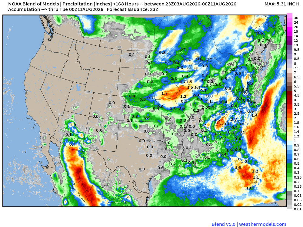
Next 7-days Blend of Models Precipitation
ECMWF HRES | Precipitable Water | My Favorite Parameter | Atlantic Tropics
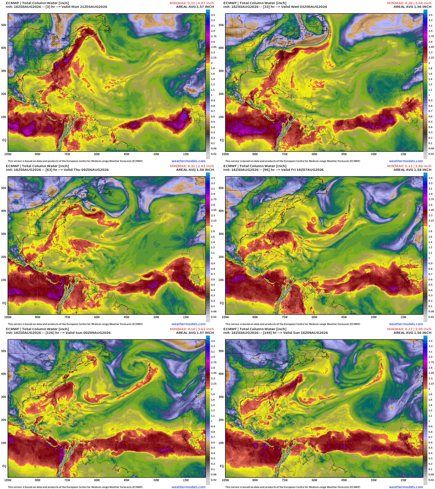
Saharan Air Layers like giant frontal boundaries sweeping through the Main Development Region with tropical waves to the south in the ITCZ/monsoon trough
Strong tropical wave at lower latitudes has moved off the African coast, and has a circulation, but it’s quickly flattened out in 24-48 hours as it heads westward.
We’re heading into Cape Verde season with tropical waves more robust and conditions in the MDR better even in the face of the El Niño, so we need to monitor everything regardless of the negative background environment.
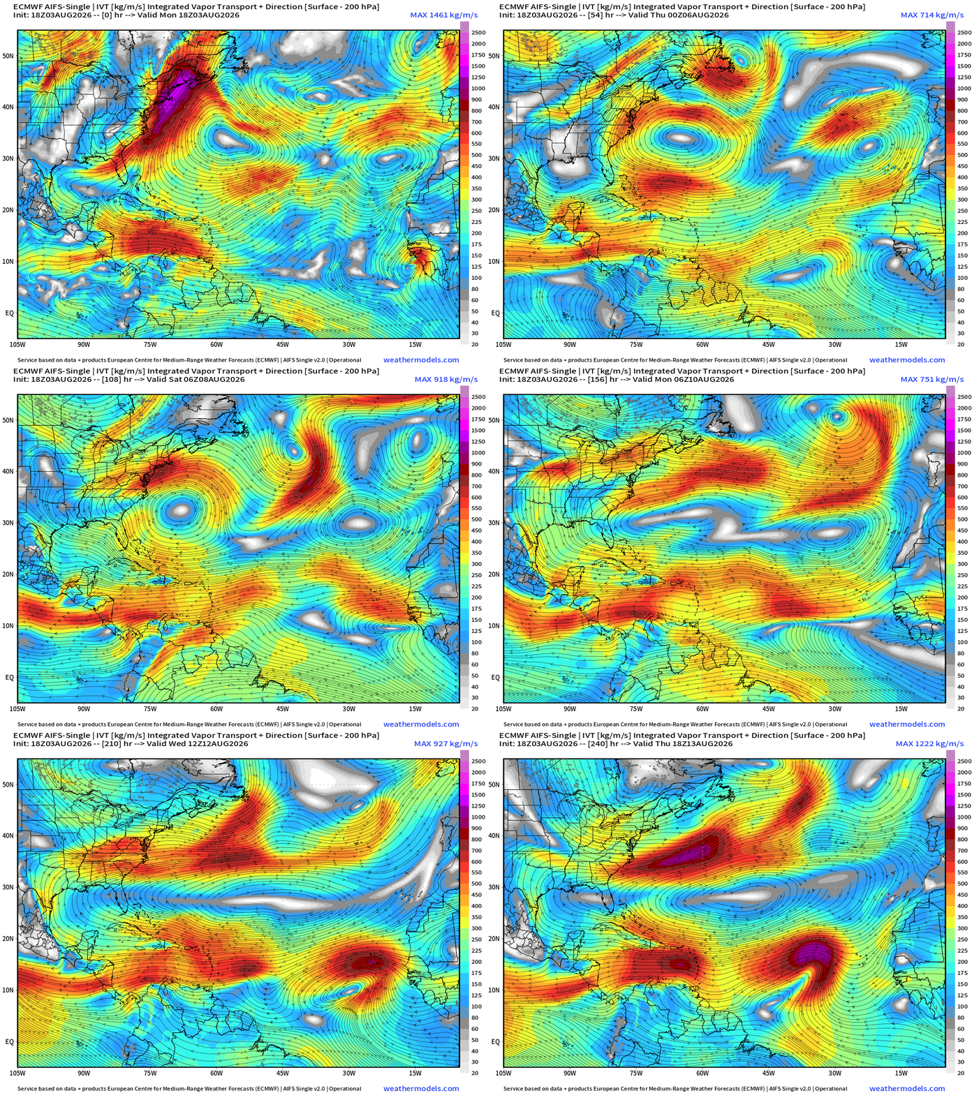
Flagship model: ECMWF AIFS 18z —> Integrated Vapor Transport next 10-days
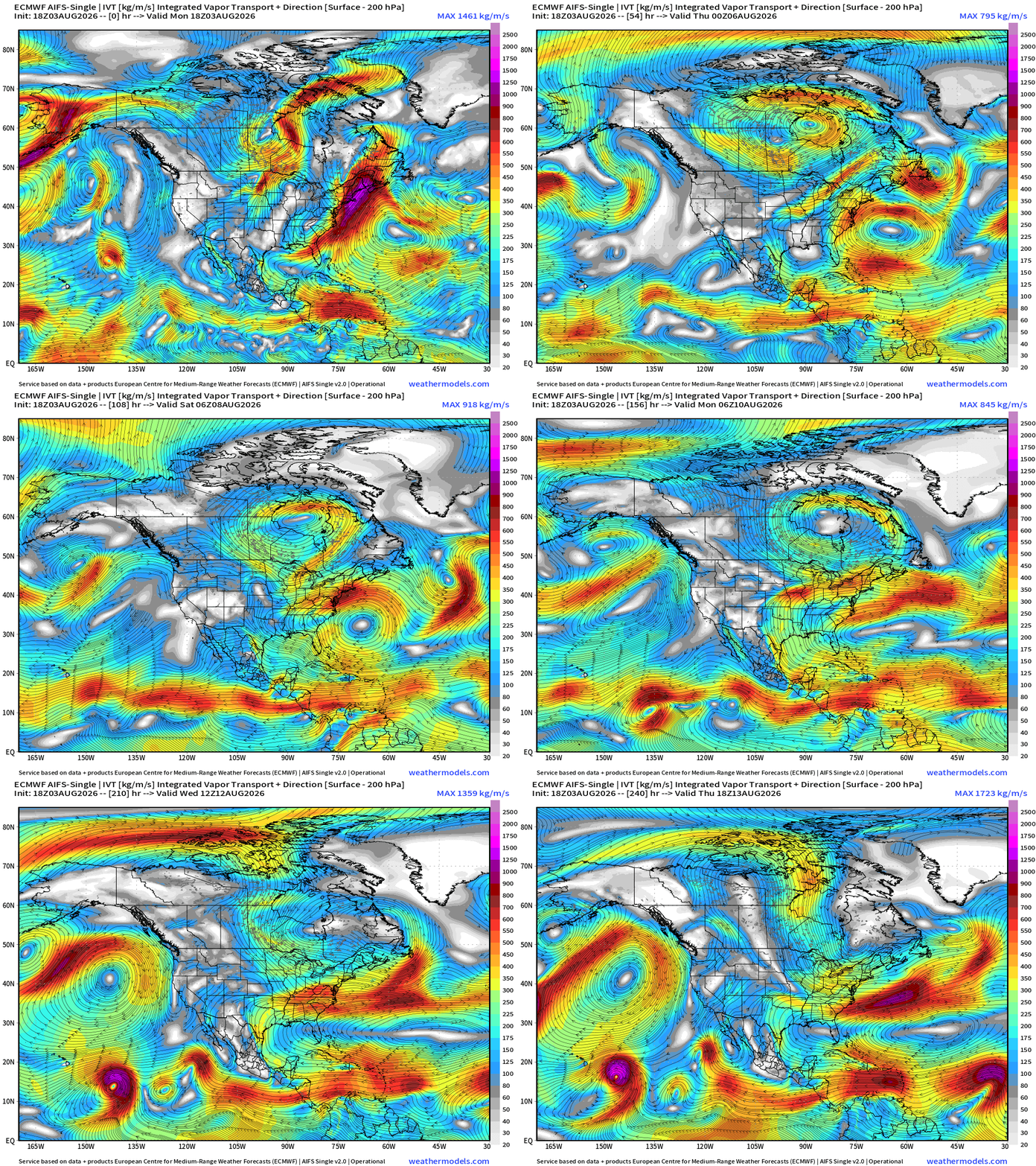
A hurricane could form out of the Eastern Pacific and head east of Hawaii in 7-10 days
More robust Atlantic tropical wave enters the frame into Day 10.
Mid-Level 500 mb Height Anomaly next 10-days
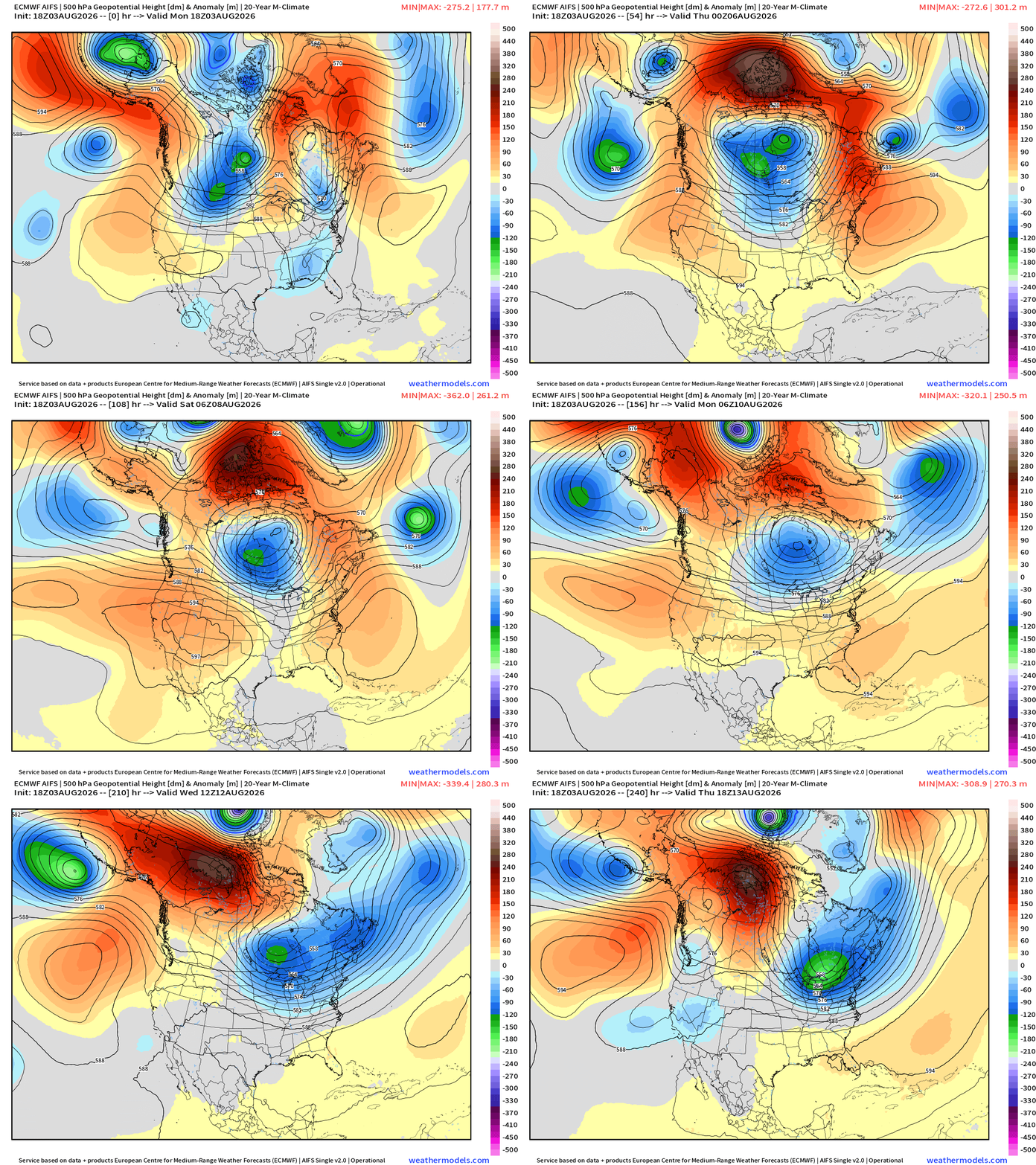
Mid-August still appears unsettled across the Great Lakes and Northeast with repeated troughs … and that means temperatures are knocked down from what could be the dog days of August with heat domes. Good news — as we are quickly running out of summer.
Current Temperatures — 8:30 PM ET
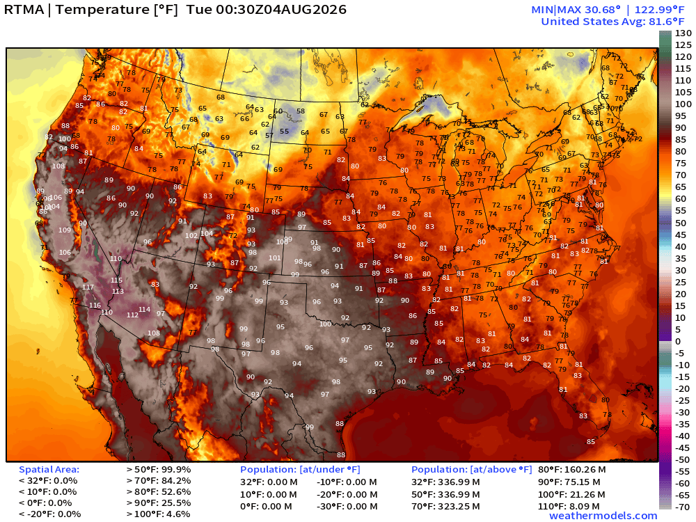
Only in the 50s and 60s across the Northern Rockies with comfortable 70s and 80s across the Great Lakes, Northeast, and Mid-Atlantic this evening. Perfect.
Current Temperature Anomaly — 8:30 PM ET
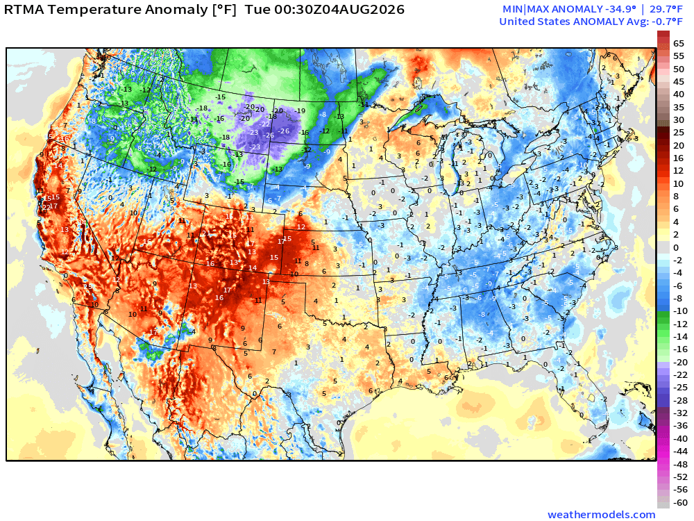
Lower 48 average temperatures were -0.7°F below normal!
High Temperatures next 9-days —> August 12th (Wednesday)
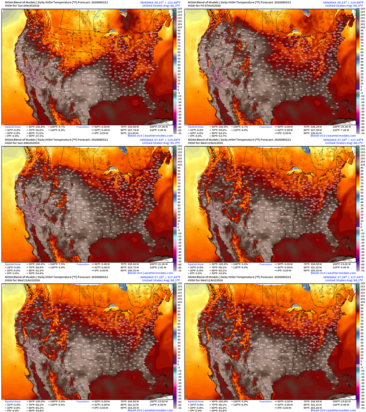
Heat remains across the Western U.S. and Texas, but not seeing any major heat wave for the Midwest, Great Lakes, Mid-Atlantic, or the Northeast through August 12th.
Low Temperatures Tuesday Morning
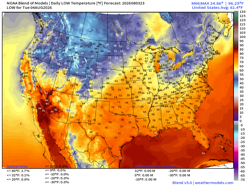
30s and 40s popping up in the norther Rockies, and only in the 40s and 50s across the Northeast, too!
High Temperatures on Tuesday
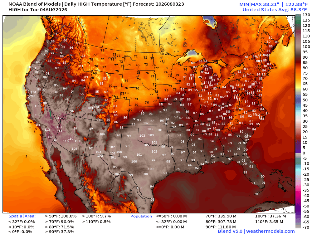
Perfect — only 70s for the central U.S. but 100s in the Plains heading into Texas and then across the West
Next 7-days | Week 1 Ensemble Mean Temperature Anomaly
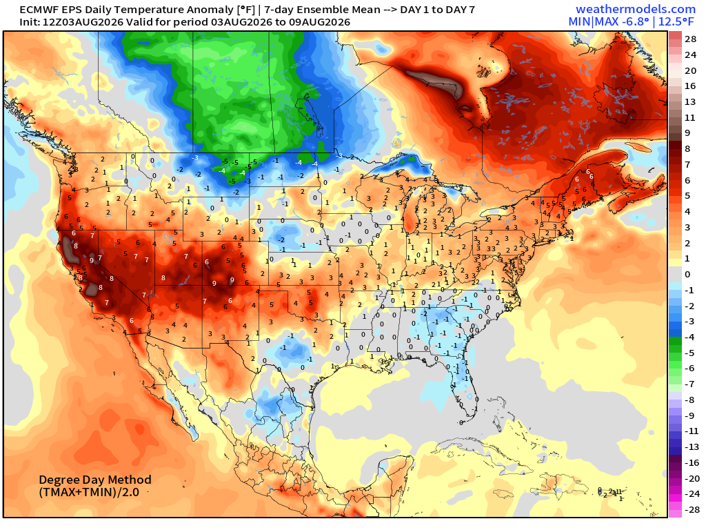
Week 2 Ensemble Mean Temperature Anomaly
Atlantic Tropics — not entirely dead but < 10% chance through 2-weeks
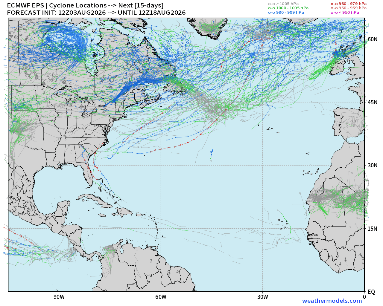
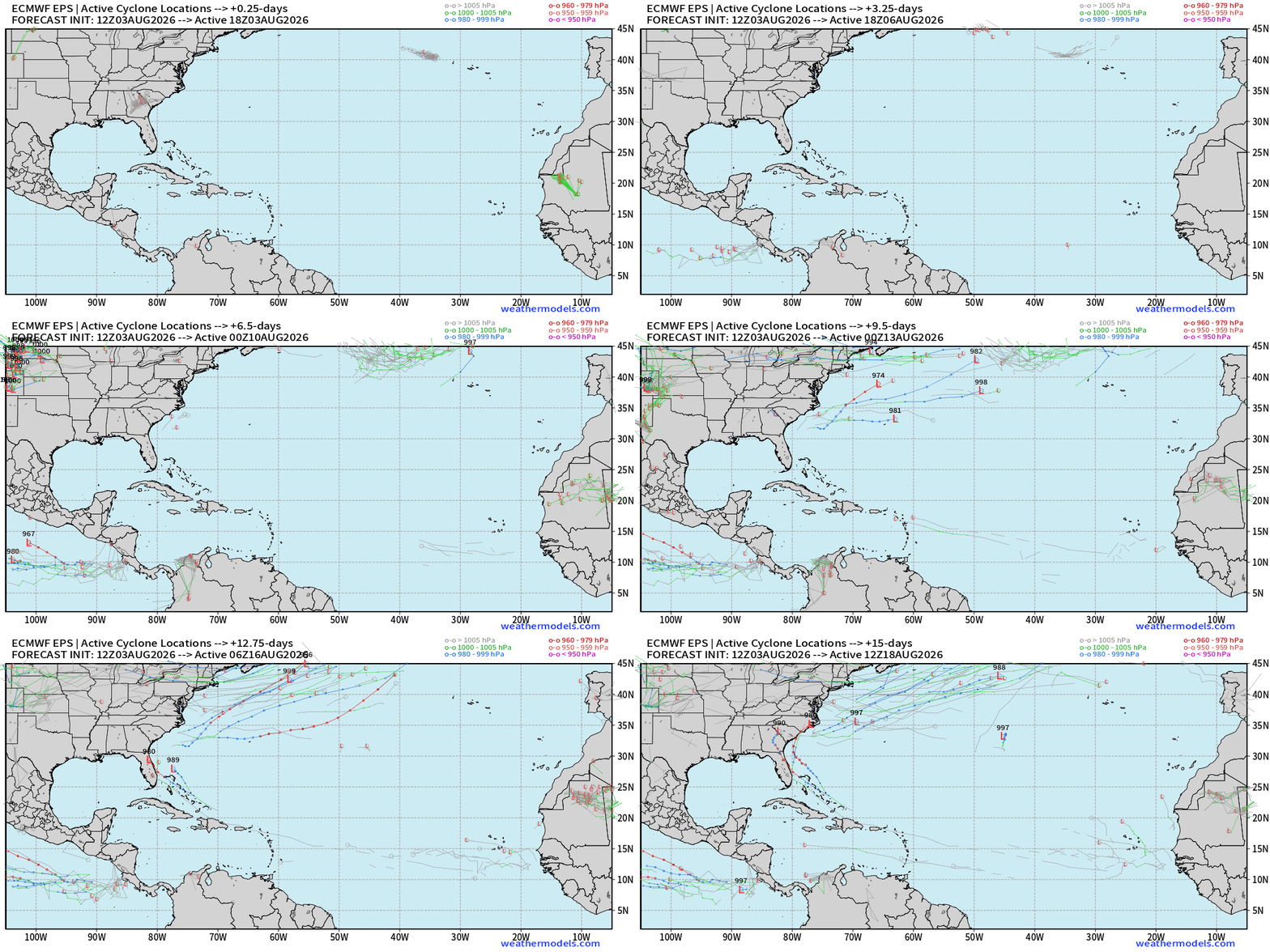
Dead quiet for next 7-days and ensembles show 15-days of “ghost town” through August 18th except for 5 members.
EPS Full Physics — Tracks next 15-days — way at the end, tropical waves develop in the Bahamas — a tiny signal, but it’s there!
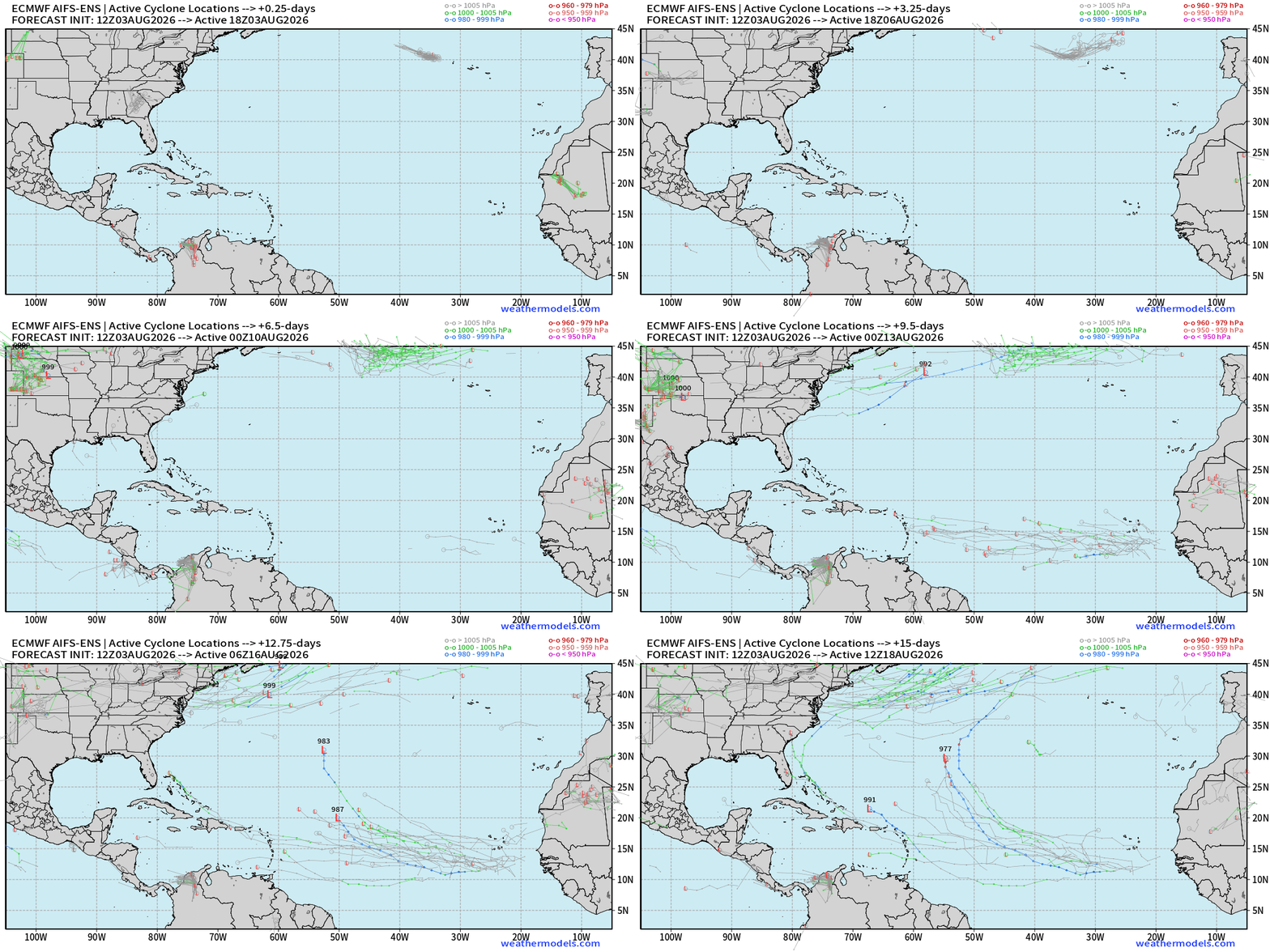
AIFS Machine Learning Next 15-days: more action out of the MDR with higher / moderate signal of something developing in mid-August
Tropical Waves — Lined up 5 deep from the Pacific to coast of Africa, but nothing is flagged as developing
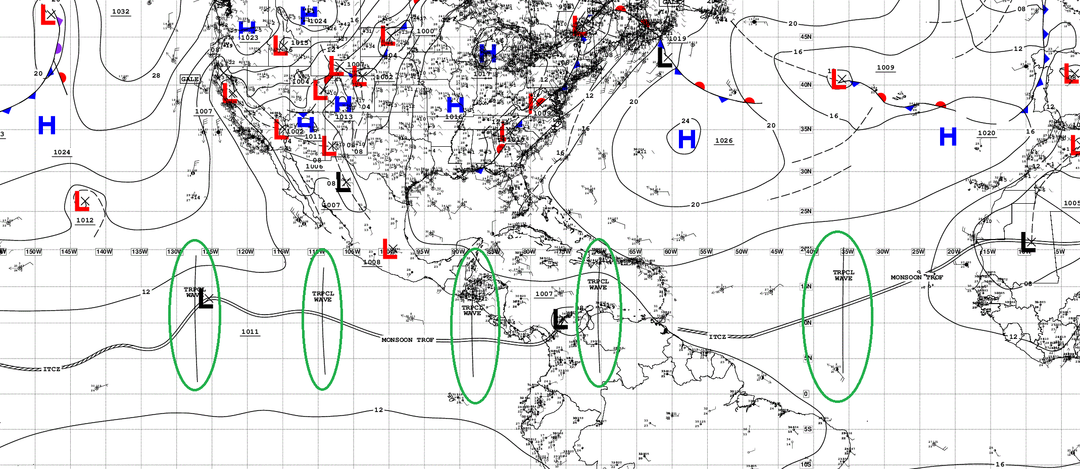
None of the waves in either Eastern Pacific or North Atlantic are marked through 7-days for development. 0%
A healthy tropical wave coming off African coast into the Atlantic tonight
Tropical Atlantic Convection from Squall Cloud
Not much to mention! The yellow/orange is dry and stable air at mid-levels.
SST and Anomaly
Sub-26°C = green still cutting into the MDR through the central Atlantic. That’s near the 30-year climatology so the “bare minimum”. Atlantic is not open for business until you get in to the Gulf and Caribbean, and there the wind shear is wiping everything out.
NASA Dust (GEOS-5) — Saharan Air Layers continue to cruise across the Atlantic doing damage to tropical waves and stabilizing the tropical environment with warmth at lower levels. Enormous SAL event happening now, and will continue for the next 5-days and not stopping after that!
AIFS Integrated Vapor Transport next 10-days —> tropical waves churn westward, and into second week of August, peeping twin waves in the MDR in 7-9 days that bear watching — especially with the AIFS-Ensemble latching on.
Western Pacific Typhoon Basin
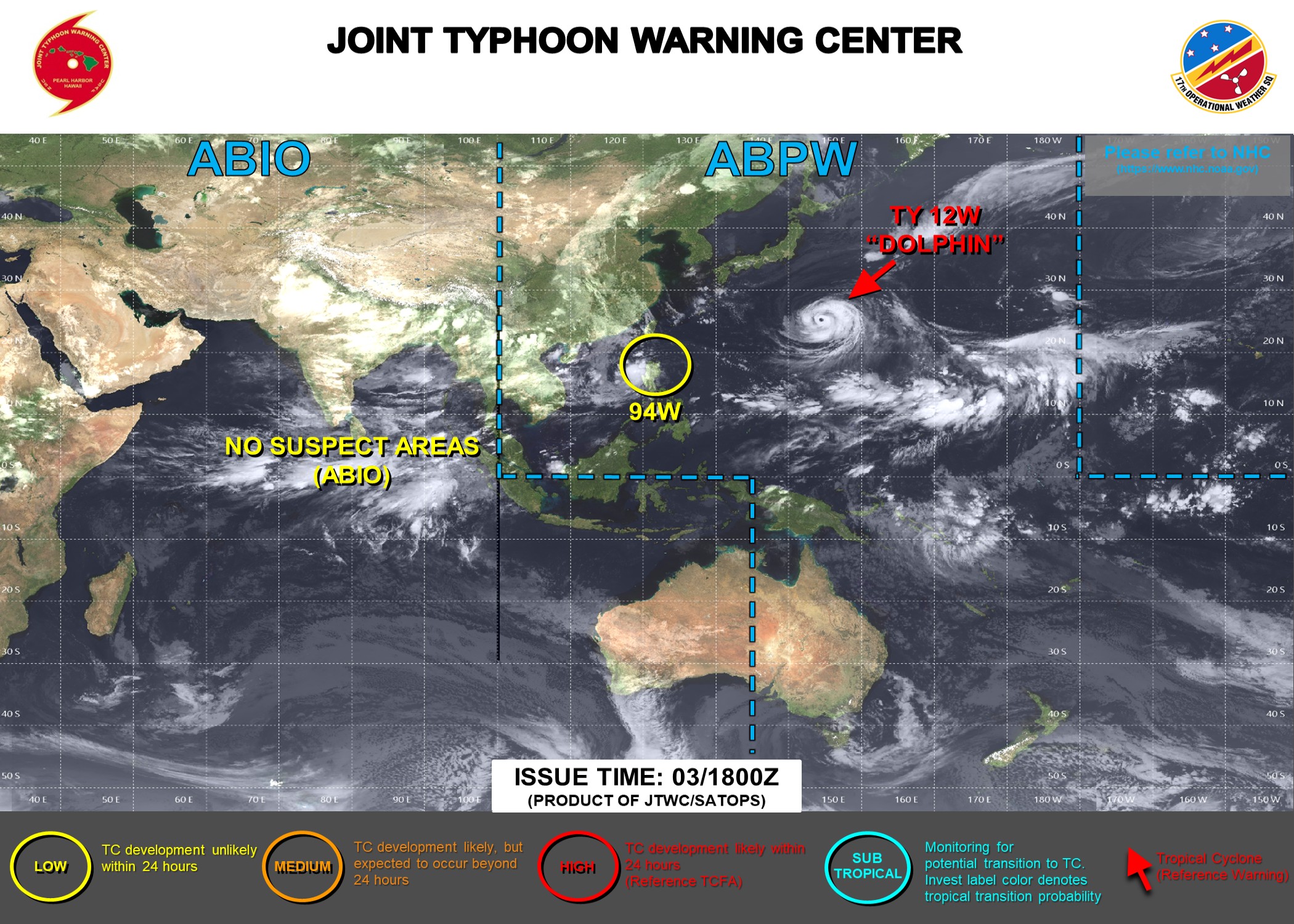
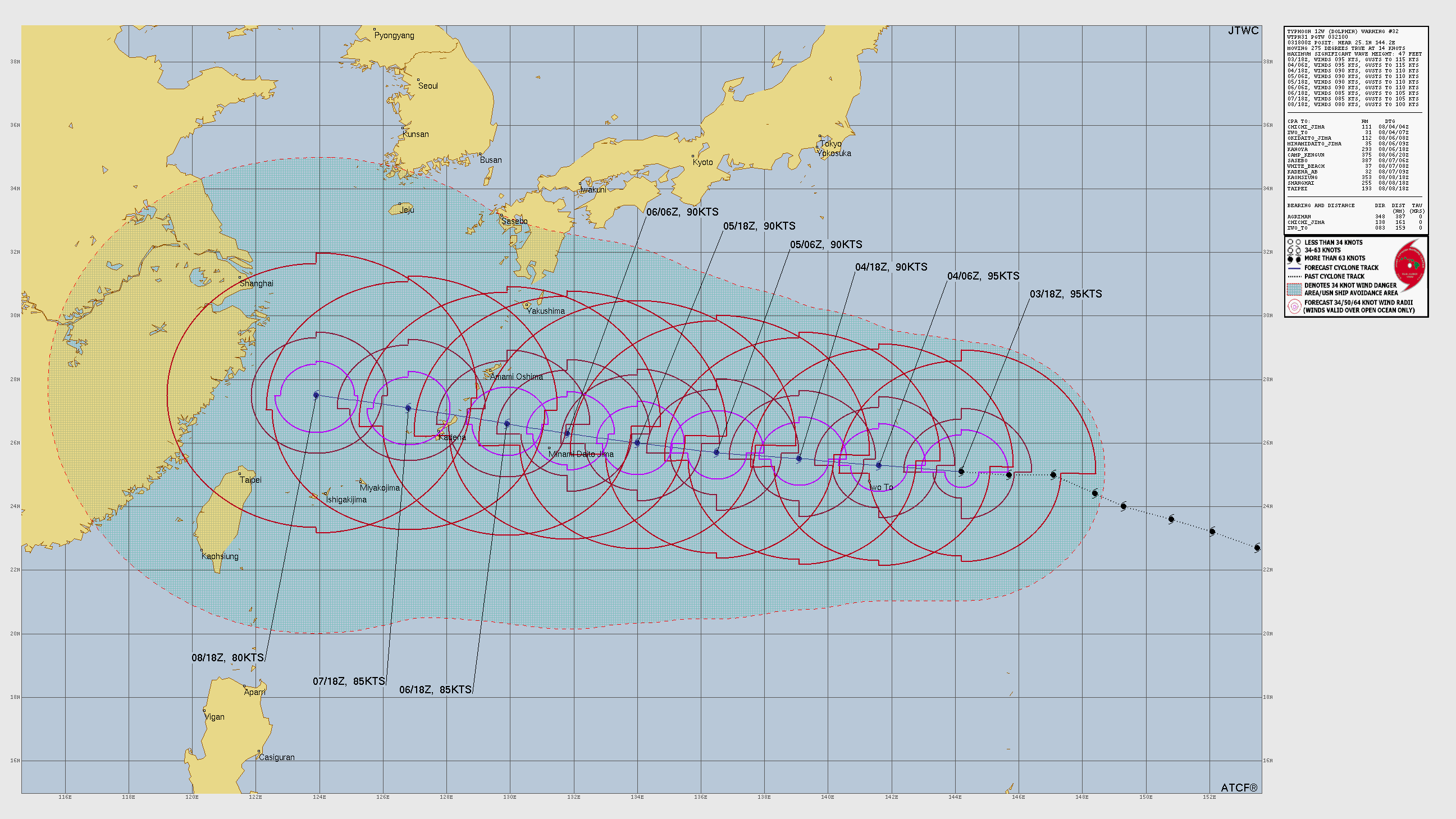
JTWC only at 95-knots with slow weakening into weekend, but not quite yet a landfall in China.
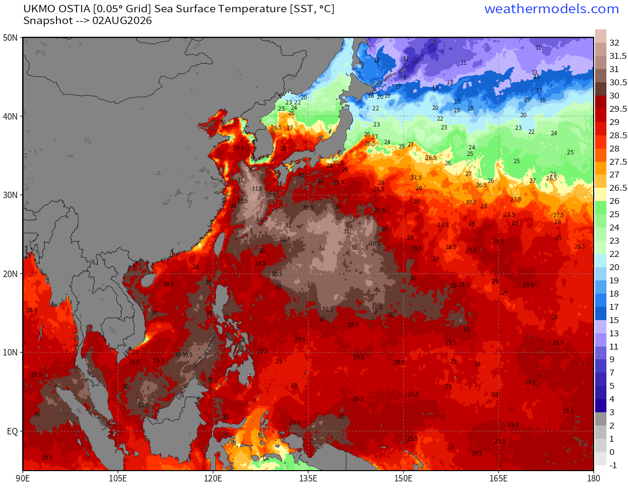
SSTs —> massive expanse of 30°C to over 31°C water in the path of Dolphin
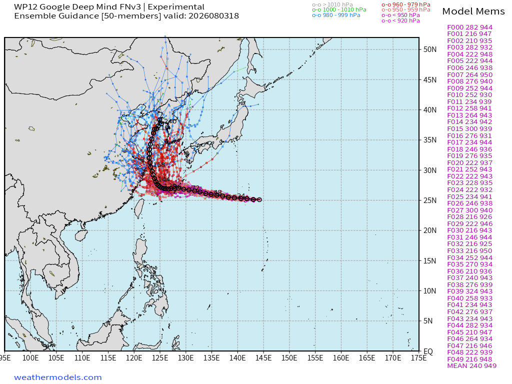
Ensemble Track into China from Google Deep Mind shows a northward bend in the mean as Dolphin approaches the coast in 5-6 days.
EPS 12z (full-physics) was WNW right along the coast.
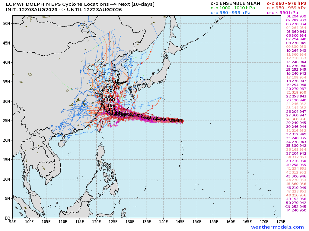
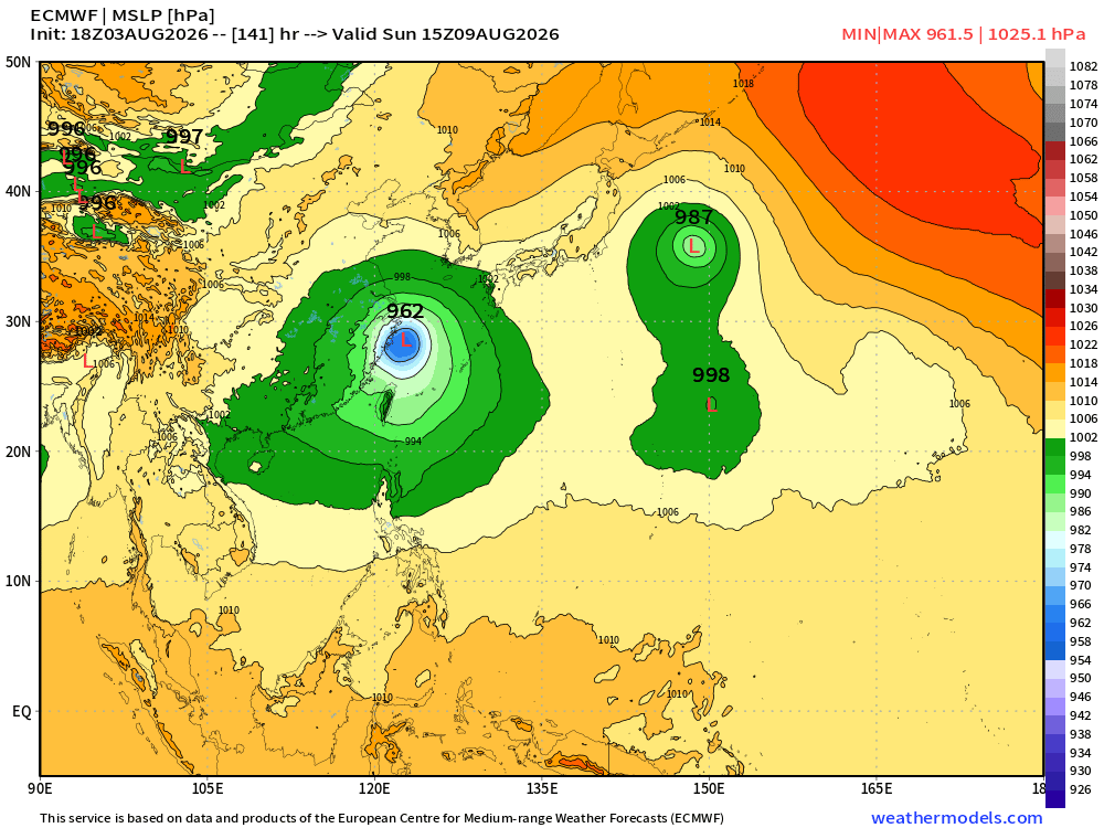
ECMWF 18z | Updated has a coastal impact but not quite a landfall
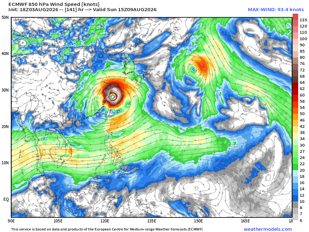
962 mb would be near major hurricane intensity with a MASSIVE wind field
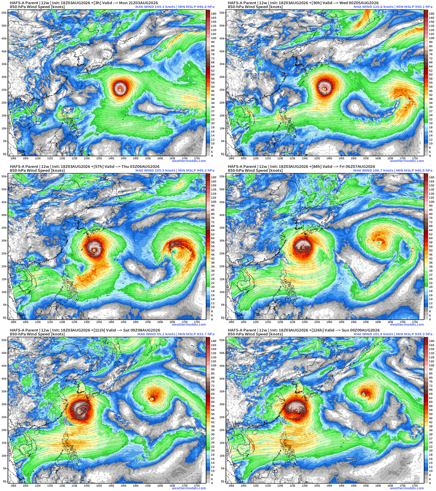
HAFS-A 850 mb Wind Nest —> Dolphin has a very large wind field & it is expanding even more in the days ahead
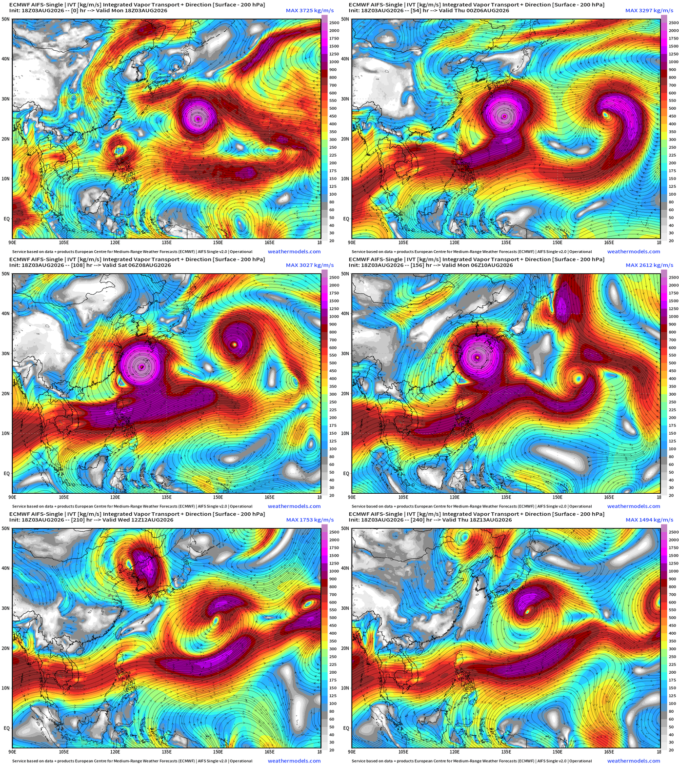
Integrated Vapor Transport from ECMWF AIFS 18z shows evolution of Dolphin near the coast of China, then an abrupt right turn to the north — so there is still uncertainty about an actual landfall in China, or instead into Korea — we’ll know more on Tuesday.
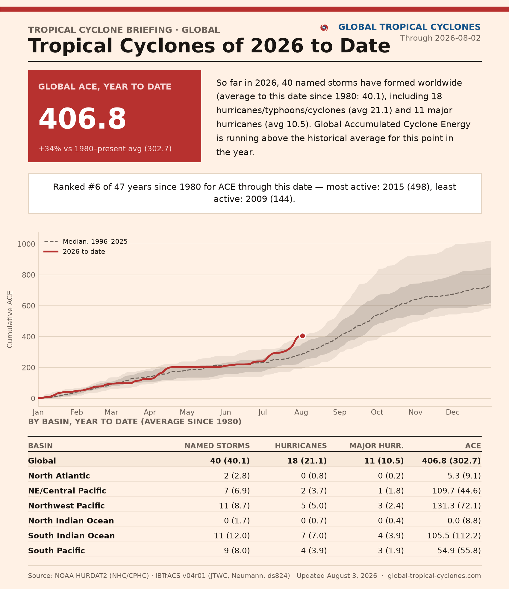
See Global Tropical Cyclones for more ACE information | 407 for Year-To-Date!
Maps sourced from weathermodels.com designed and innovated by yours truly! Please subscribe there for real-time access to the newest maps, charts from all of the weather models including ECMWF and AIFS, and NOAA GFS/GEFS, HRRR/RRFS and Blend of Models (NBM). NOAA WPC and SPC for fronts/convective outlooks. Our own content is now sourced from hottestsince.com and weather.city and celsius.earth, and squall.cloud and weather.football and global-tropical-cyclones.com
My Atlantic Hurricane Season Forecast (2026)
From April 7, 2026: Atlantic Seasonal Hurricane Forecast: (11/5/2)
9-13 Named Storms (11 most likely)
4-7 Hurricanes (5 or 6 most likely)
1-3 Major Hurricanes (2 most likely)
Accumulated Cyclone Energy: 75-85 (well below normal)
NOAA 2026 Atlantic Hurricane Season Forecast
- Milepost
- 998 · laid 2026-08-04T01:25:24.184000Z
- Source
- https://weather.substack.com/p/august-3-2026-monday-tropical-update
- Digest
- 4121391bf16abb43e20b260ee0394fc9b8f1e8ce001c38ce08b86f5b255b234e
- Machine
- JSON