September 7, 2023 Hurricane Season
Hurricane Lee forecast to become Category 5 on Friday
September 2023 was the 9th-warmest September in the 131-year national record (1895–2025), at 67.7°F against a 1991–2020 normal of 66.0°F (+1.8°F).
September 2023 was the 27th-driest September in the 131-year national record (1895–2025), at 2.1in against a 1991–2020 normal of 2.6in (-0.4in).
NOAA/NCEI Climate at a Glance, contiguous United States. This is the observed record for the month, not a score of anything said in this piece — the forecast ledger begins 2026-08-17 and cannot reach earlier posts.
Hurricane Lee undergoing rapid intensification
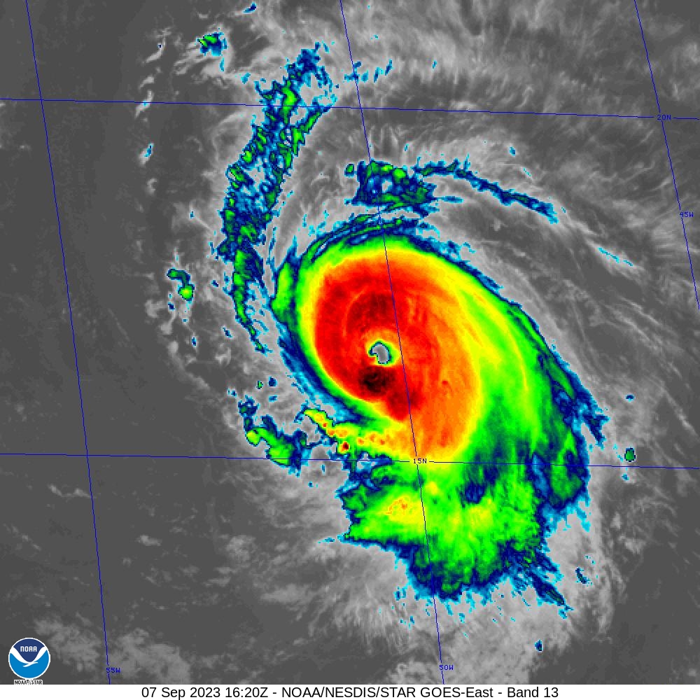
After battling wind shear, Lee has hit the gas pedal intensifying to nearly a Major Hurricane this morning (11 AM) with expectation of Category 4 later Thursday an Category 5 on Friday. The maximum intensity is forecast to 140-knots, but based upon what was just seen with Jova over slightly cooler waters in the Eastern Pacific, I’m going to go with 155-knots (T 7.5 Dvorak) for Lee. As of 12 PM ET, the satellite intensity algorithm has peaked at T 6.3. This will go up dramatically has darker black colored convection wraps around eye later today.
Lee will track WNW for the next 5-7 days but slow down east of the Bahamas. Thereafter, a due northward track is anticipated between 65°W and 70°W longitude.
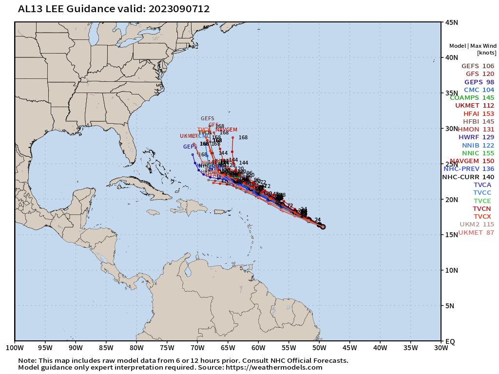
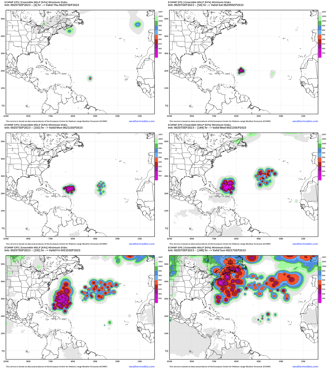
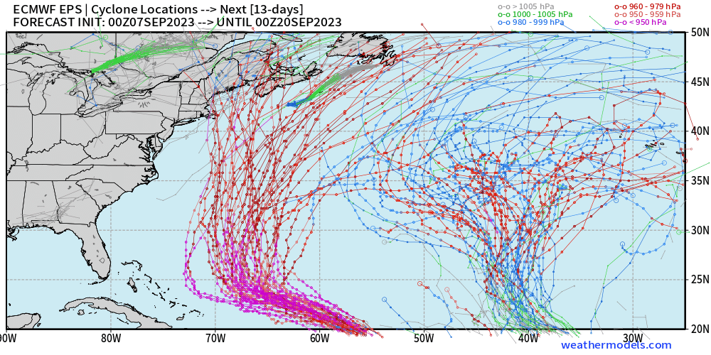
The best way to visualize the uncertainty of Lee’s track after about 5-7 days is to show the minimum SLP of each member plotted on a map and animated. Through 10-days, there is considerable along track variability (speed of movement) and expansion of the solution envelope (cone) encompassing New England and Atlantic Canada.
Why no “out to sea” solution like Franklin? TD 14L —> Margot has entered the chat. Since Margot will be powerful — perhaps a major hurricane — there will be a high pressure smooshed in between to block any eastward movement of Lee. Medium range forecasts have considerable errors even without 1 or 2 major hurricanes. This is surely a challenge.
Hurricane Lee (13L)
Hurricane Lee has reached 105-mph (90-knots) at 16.4°N and 50°W and is moving WNW at a brisk 15 mph. That track direction will continue for the next 5-days according to model guidance and NHC human forecasters, but will slow to a crawl by next Tuesday NHC has Lee reaching about 66°W, and we’ll keep an eye on the longitude for the turn north.
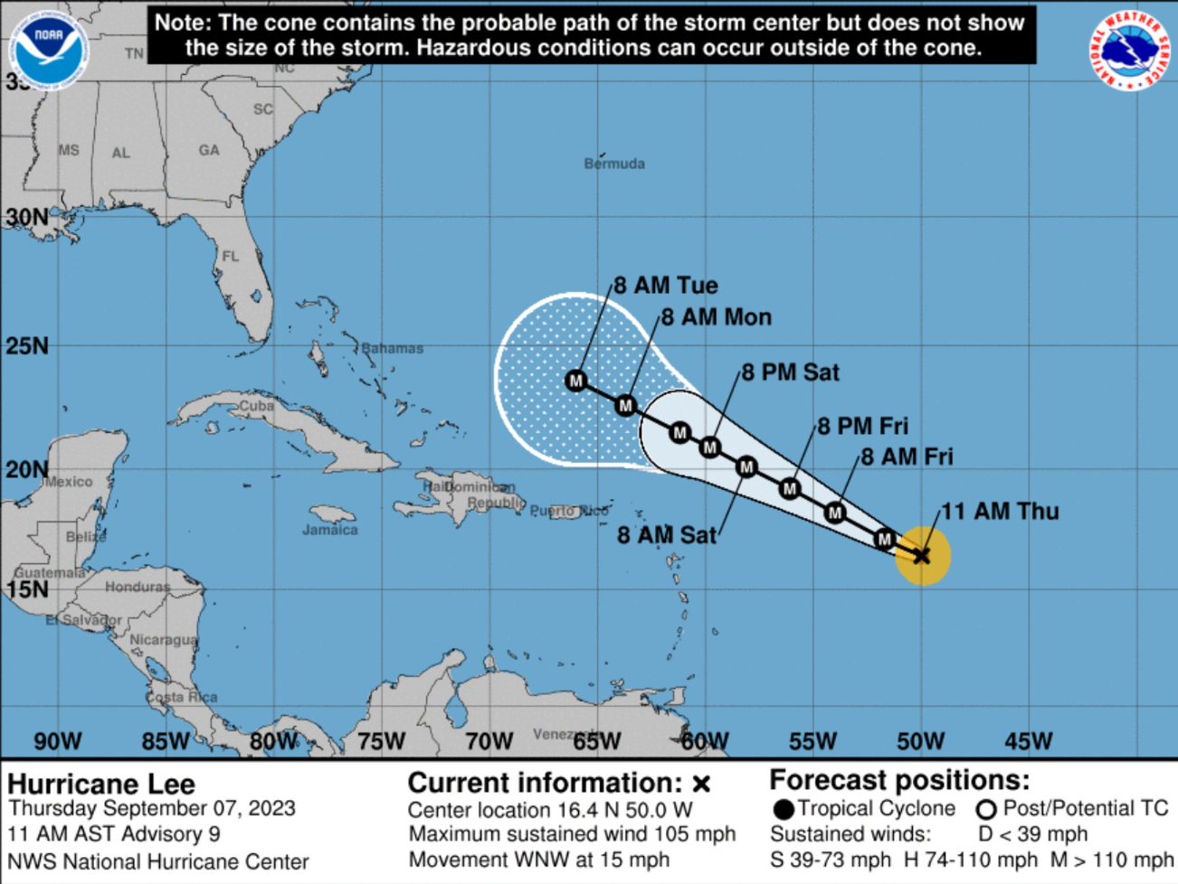
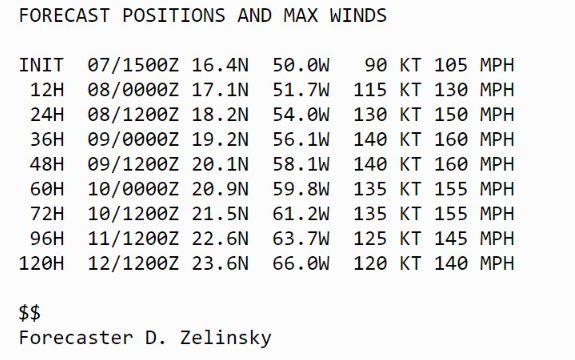
Hurricane Lee is forecast to reach major intensity to Category 4 in 12 hours, and continue up to Category 5 (140-knots) at least. Of course, there is no Category 6 hurricane officially, but it would probably be around 160-knots if the Saffir-Simpson scale extrapolated upward.
Model Guidance (EPS 00z)
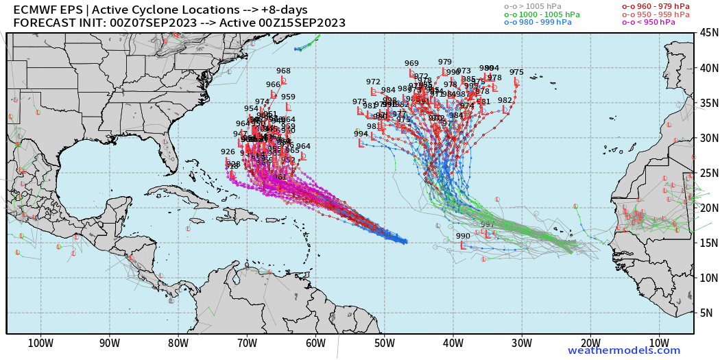
Complicate forecast in the medium-range with Lee and Margo co-existing. At Day 8, along-track spread for Lee is large, while cross-track spread for Margot dominates.
I haven’t sorted the individual members, but later at Day 13, we see that New England is within the large envelope of spaghetti solutions for Lee. I would assume there is some interplay between Lee and Margot to make this all work. We’ll be digging into that over the coming days for sure.
2023 Medium Range Atlantic Tropics
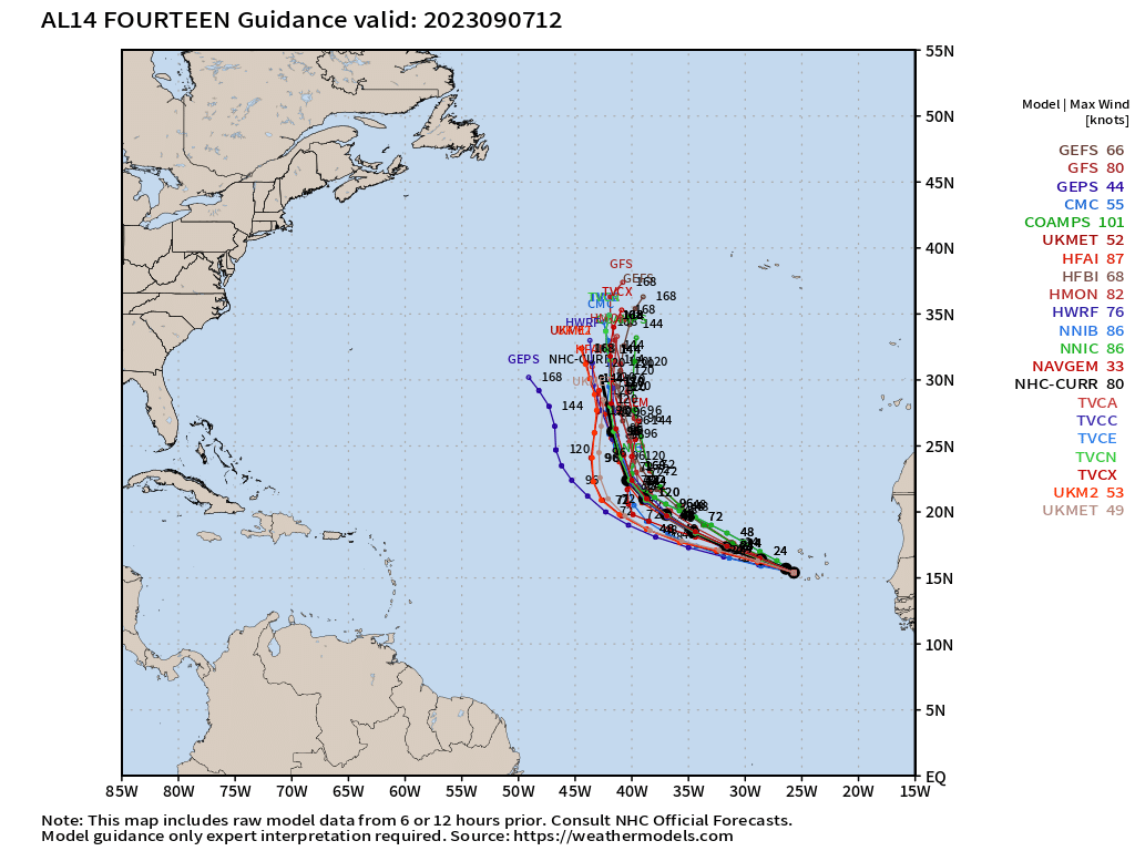
Tropical Depression 14L was designated and will become Margot. It will quickly head to the north but remain over warm waters. This should allow Margot to reach major hurricane status in 4-6 days.
Atlantic 2023 Year to Date | ACE: 61 (138% normal | 44)
Unnamed Subtropical Storm [January 2023]
Arlene 02L: 35 knots, Bret 03L: 60 knots, Cindy 04L: 50 knots
Don 05L: 65 knots, Emily 07L: 45 knots, Franklin 08L: 130 knots
Gert 06L: 40+ knots, Harold 09L: 45-knots, Idalia: 115-knots
Jose: 50-knots, Katia: 50-knots, Lee: Category 5 hurricane
Margot is next
2023 Eastern Pacific Hurricane Season
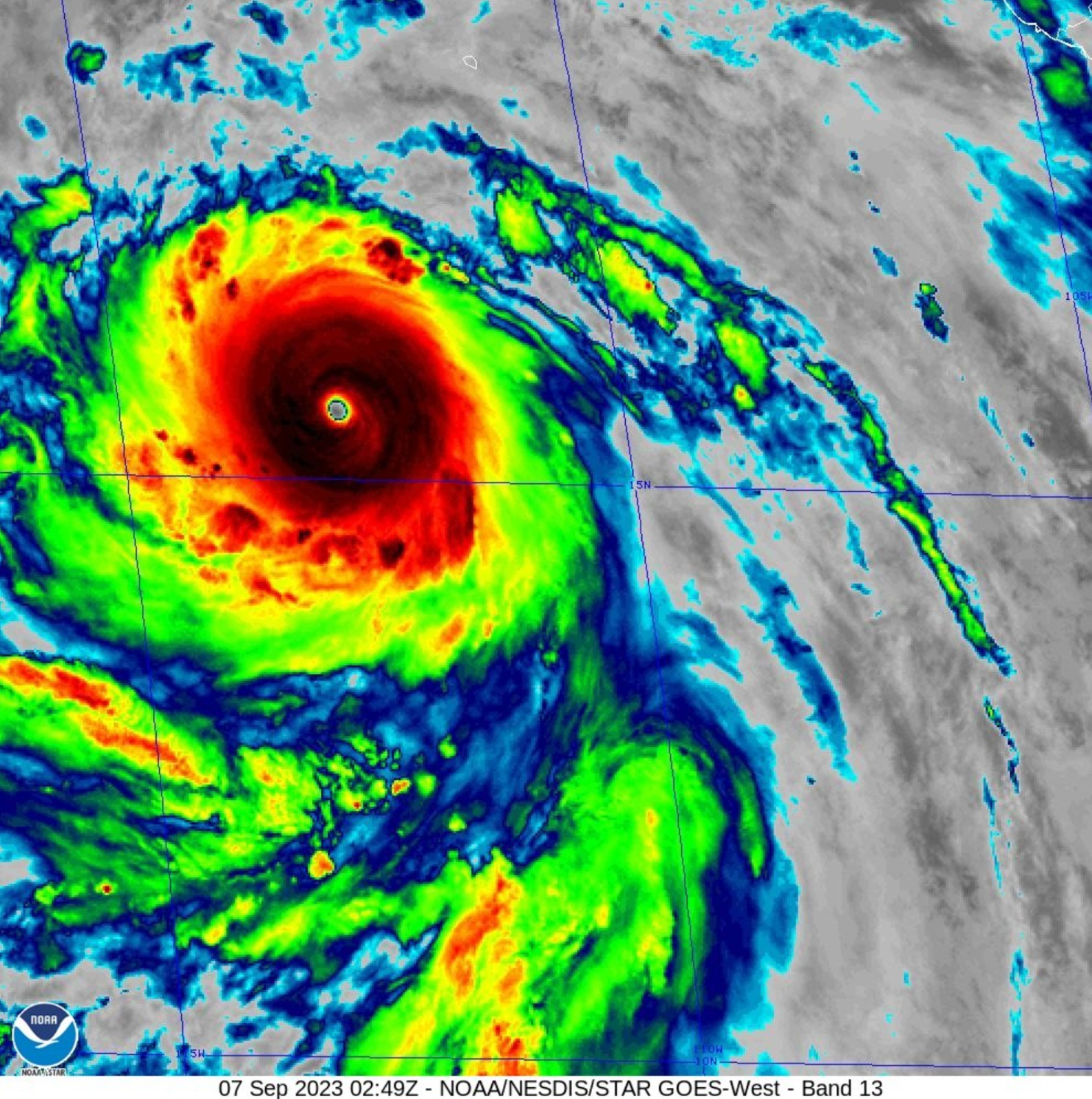
Hurricane Jova exploded overnight into a Category 5 monster. Satellite intensity algorithms went to T 7.8 consistent with a 155-160 knot storm. NHC went with 140-knots even with KNES at T 7.5. Maybe they’ll clean that up in the best track.
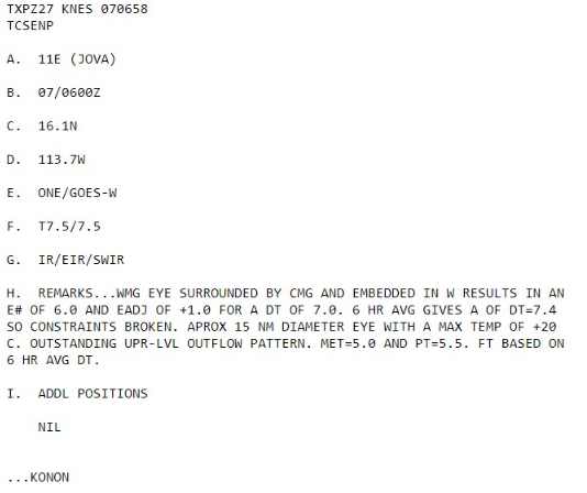
Interesting that Jova rapidly intensified over rather typical/normal waters of 29°C to 29.5°C over the Eastern Pacific. Thinking more about this to put into the context of climate change.
Eastern Pacific 2023 | Year to Date ACE 113 (131% of normal | 86)
Adrian 01E: 90 knots, Beatriz 02E: 75 knots, Calvin 03E: 110 knots
Four 04E: 30 knots, Dora 05E: 125 knots, Eugene 06E: 60 knots
Fernanda 07E: 115 knots, Greg 08E: 45 knots
Hilary 09E: 125 knots, Irwin 10E: 40 knots, Jova: 140 knots
2023 Western Pacific Typhoon Season
Tropical Storm 12W (Yun-yeung) is still heading toward Japan, but only minimal impacts.
Western Pacific Typhoon 2023 YTD ACE: 213 (146% normal | 145)
Sanvu 01W: 30 knots, Mawar 02W: 160 knots, Guchol 03W: 90 knots
Talim 04W: 85 knots, Doksuri 05W: 130 knots, Khanun 06W: 120 knots
Lan 07W: 115 knots, Damrey 08W: 65 knots, Saola 09W: 135 knots
Haikui 10W: typhoon, Kirogi 11W: tropical storm, Yun-Yeung 12W: tropical storm
Thank you for subscribing! Your support pays for my servers and product development. Feel free to say hello and follow on Twitter (@RyanMaue)
- Milepost
- 92 · laid 2023-09-07T16:27:11.030000Z
- Source
- https://weather.substack.com/p/september-7-2023-hurricane-season
- Digest
- 796605cf42c0862e3512be9a6f1c5bce523e02e24fa53a3e01ca298e4a729b81
- Machine
- JSON