November 15, 2025 Saturday Weather
NOAA launches new A.I. weather models: AI-GFS and AI-GEFS
November 2025 was the 4th-warmest November in the 131-year national record (1895–2025), at 46.7°F against a 1991–2020 normal of 43.0°F (+3.7°F).
November 2025 was the 29th-driest November in the 131-year national record (1895–2025), at 1.7in against a 1991–2020 normal of 2.3in (-0.6in).
NOAA/NCEI Climate at a Glance, contiguous United States. This is the observed record for the month, not a score of anything said in this piece — the forecast ledger begins 2026-08-17 and cannot reach earlier posts.

Starting with Lower 48 precipitation type + MSLP for the next 6-days!
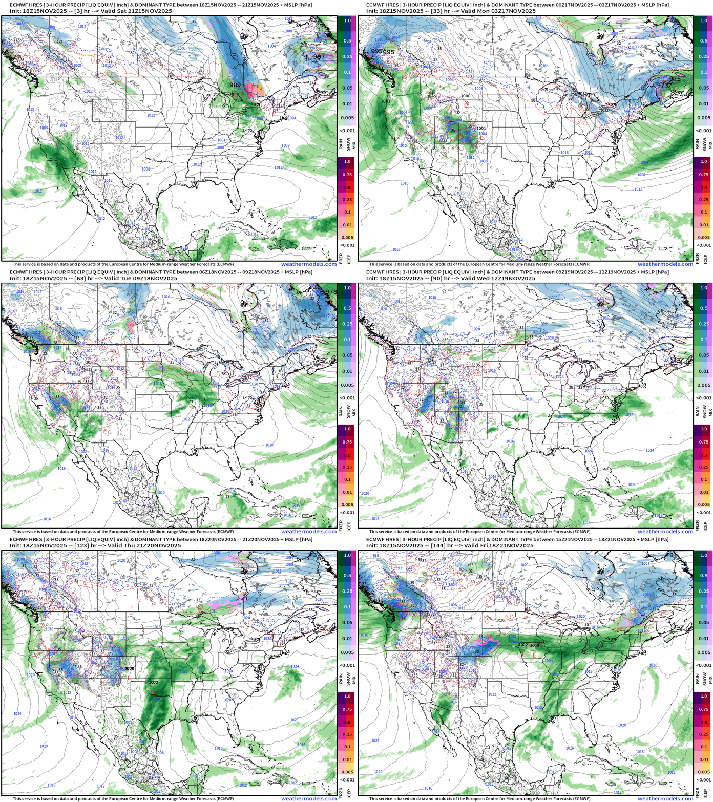
Headlines Saturday Evening
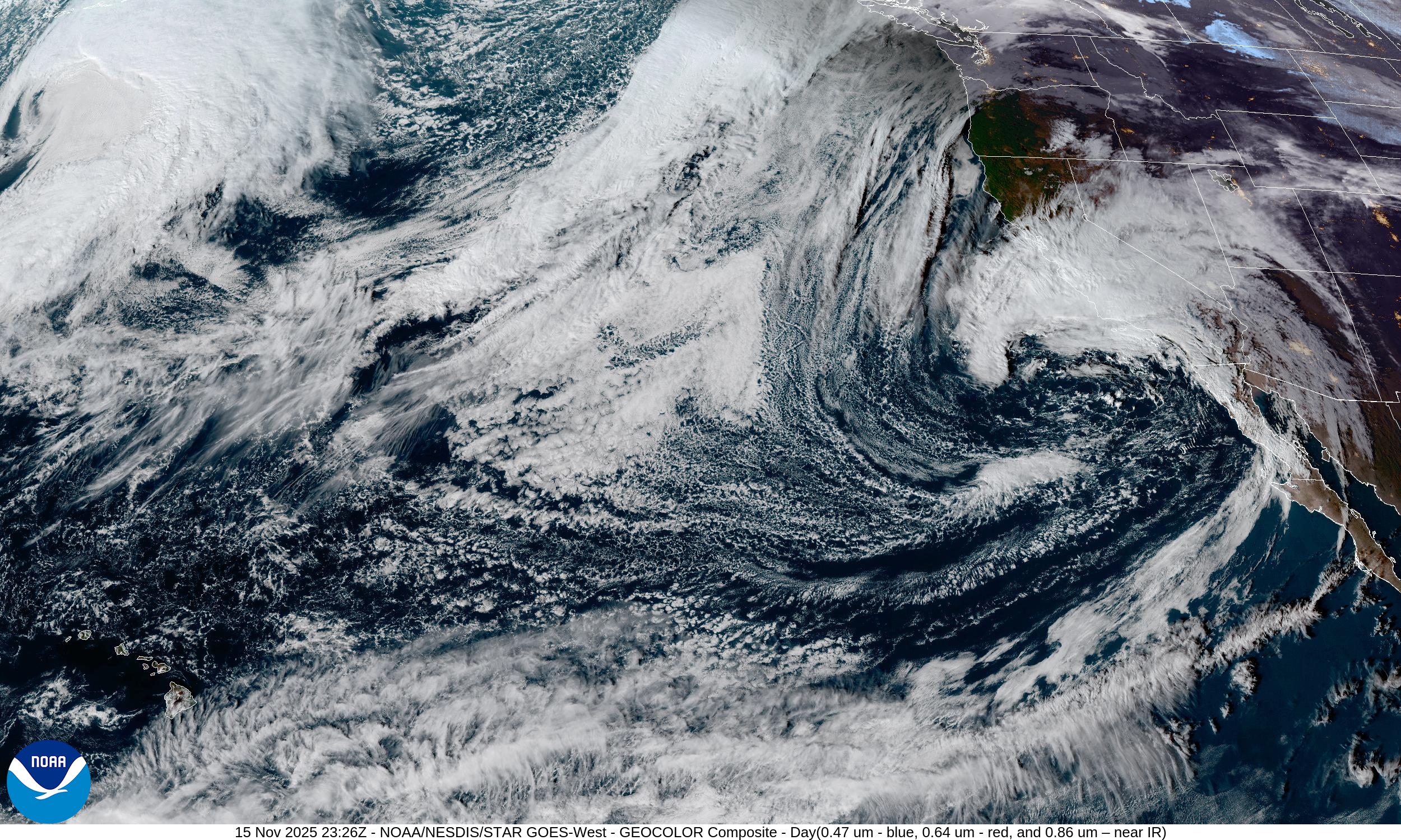
West Coast atmospheric rivers around complicated storm systems —> boatloads of rain for the state, especially in Southern California. HUGE rainfall totals into next week.
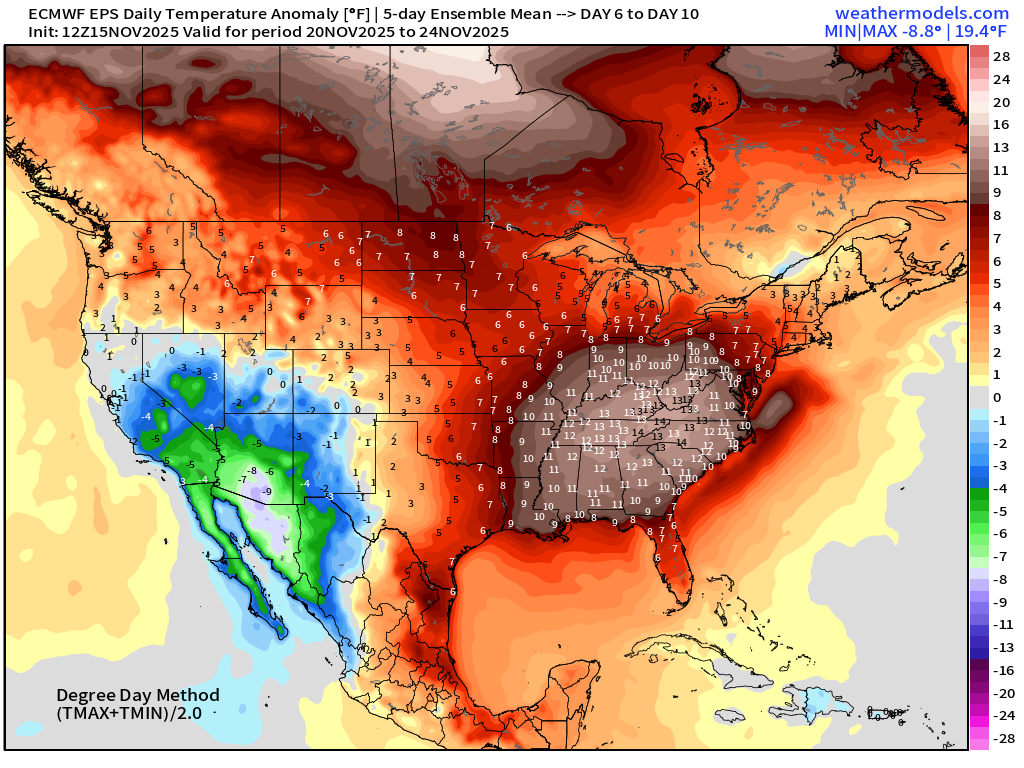
Central U.S remains warm — and that trend continues for next 10-days, at least. The Eastern U.S. is mild except for the Northeast, which warms up later next week after ditching yet another trough.
Central U.S. storm system with Gulf of Mexico moisture —> severe weather threat
Congratulations to the researchers at EPIC and the new management:
Friday, NOAA quietly launched two components of Project EAGLE into operations: AI-GFS and AI-GEFS based upon Google DeepMind GraphCast — and trained upon NOAA origin analysis (GDAS) — so we should expect different solutions than ECMWF AIFS and AIFS-ENS. The forecasts extend out 16-days and are spun up 4x per day.
AI-GFS data is operational (version 1.0) and managed 24/7 on the NOMADS data repository. The raw data files are completely available well prior to the full-physics GFS files e.g. 11:15 AM ET for the 12z suite. AI-GEFS follows up about 1-hour later with 31 members matching the initial perturbed conditions from the GEFSv12.
Yet more data for our global numerical weather prediction bucket — which requires significant post-processing in order to add value.
AI-GFS 18z | 500 mb Height Anomaly | Next 10-days
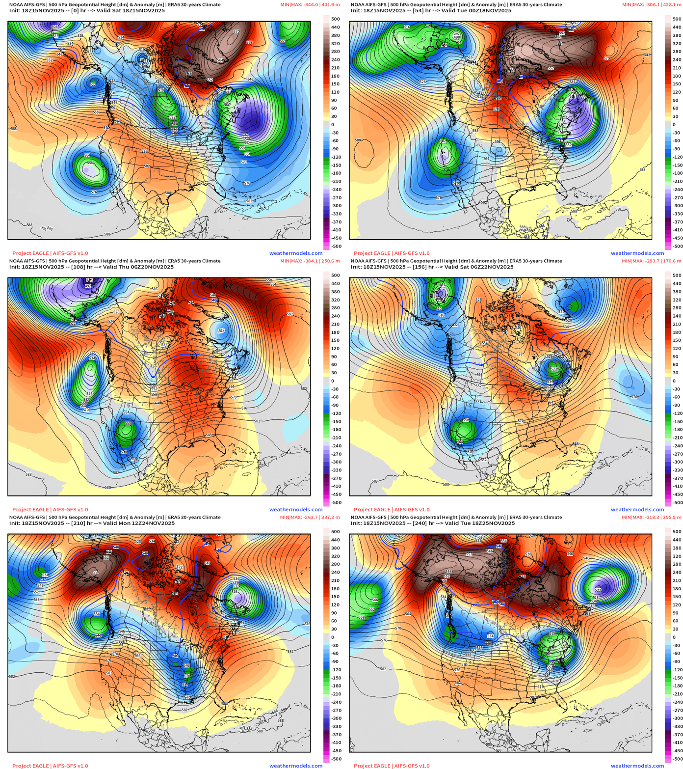
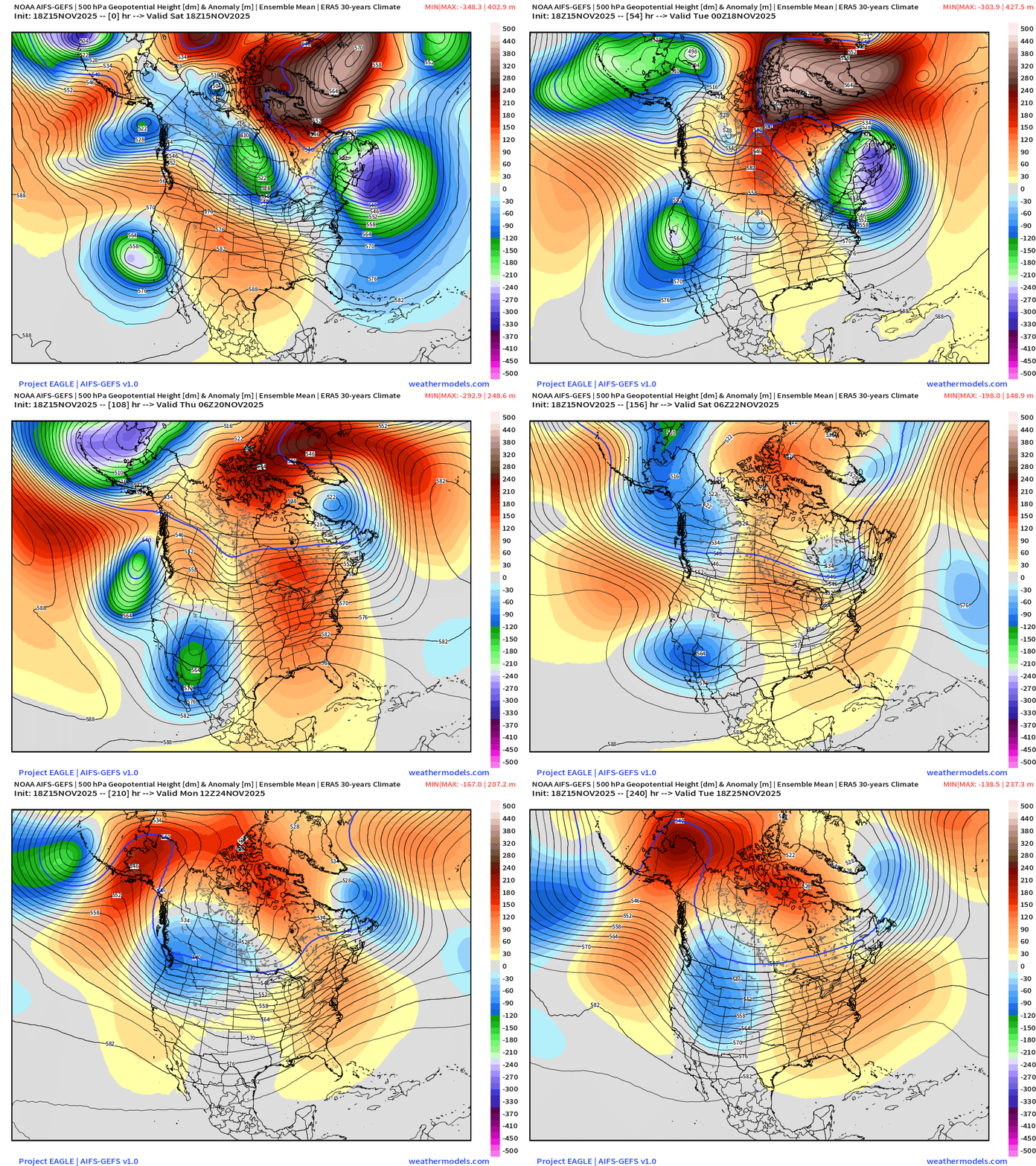
The AI-GFS will be sharper after ~Days 6-7 compared to the ensemble mean of the AI-GEFS output. The ensemble mean is a statistical field that averages the individual members. Reminder, it is not a member of the ensemble itself.
AI-GEFS 18z | 500 mb Height Anomaly Ensemble Mean | Next 10-days
In general, here on this platform, I’m going to defer to the ECMWF suite of guidance mainly because I do not know how skillful or added benefit/value of AI-GFS/AI-GEFS at this time. Efforting on that front. I was able to secure the valuable https://x.com/weathertrader account on X.
500 mb Temperature | Mapping the Tropospheric Polar Vortex
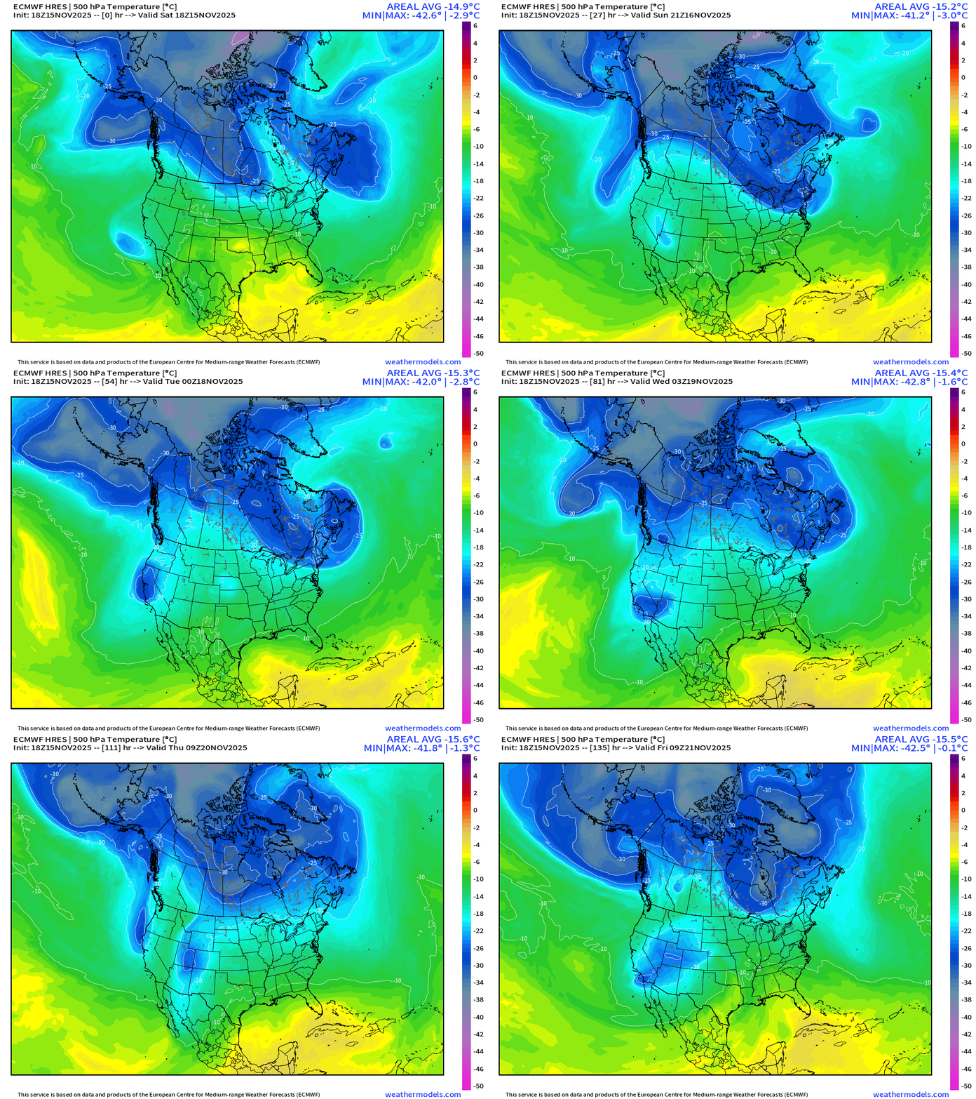
The 500 mb temperature field (middle troposphere) has become quite popular on my X feed as I’ve shared quite a few animations of both North America and Europe.
The dark blue is about -25°C and represents Arctic origin air — shows up nicely within the main blobs over Canada, and the pieces that break off with “lobes” as Rossby wave breaking or trough thinning sends little cut-off low circulations into the subtropics were they cause mischief! .
Europe —> Polar Vortex Event — Impressive!
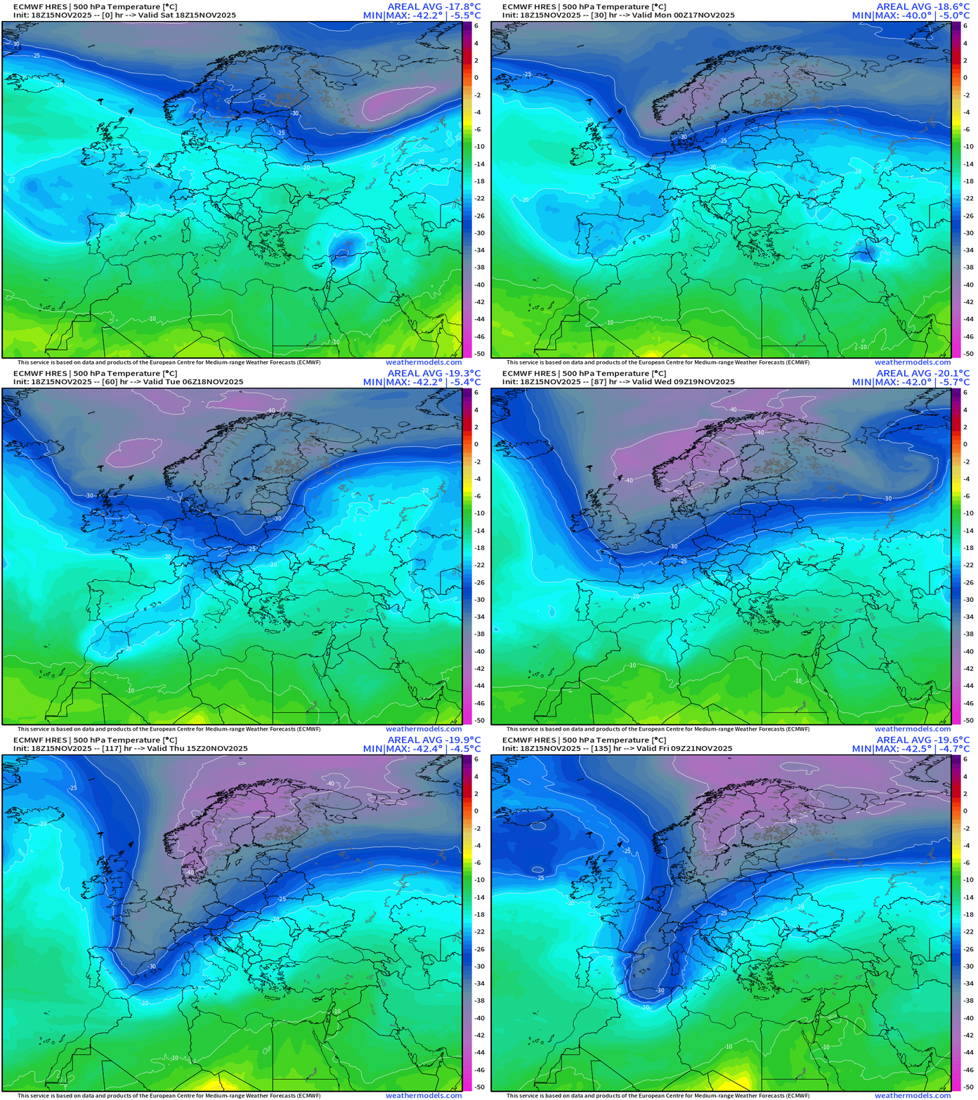
Seeing the -40°C temperatures enveloping Scandinavia but then a major Arctic blast sinks through Western Europe to North Africa with the -30°C contour scouring the western Mediterranean. Impressive for mid-November.
Coldest by Friday but not necessarily a lot of snowfall
I will do more European weather updates going forward.
Back to the Lower 48 | This Evening’s Frontal Boundaries
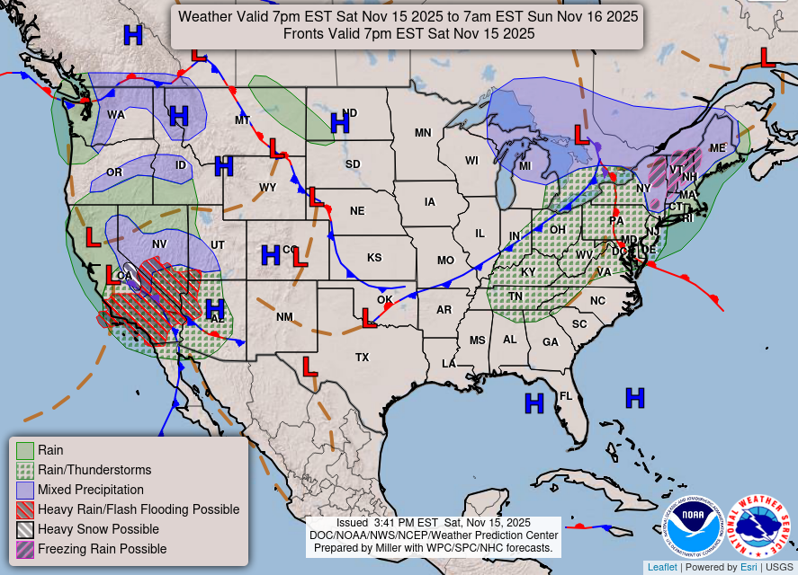
Storm system continues to spin across California — with yet another cut-off low ready to spin southward to take its place. Storm system across Northeast will spin through into Sunday morning, and leftover colder air = Lake Effect snow showers.
HRRR Simulated Radar | Next 48-hours | Through Monday Afternoon
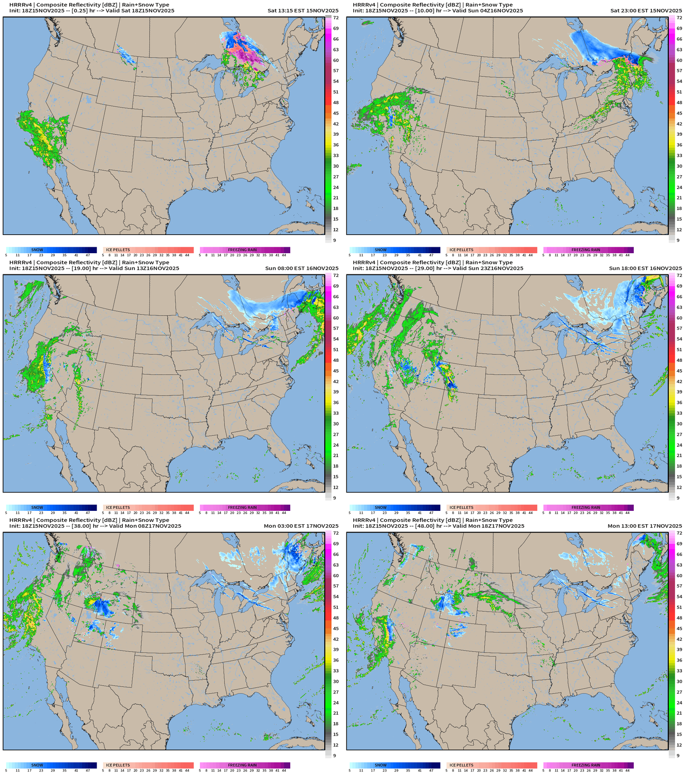
HRRR Snowfall | Next 48-hours | Through Monday Afternoon
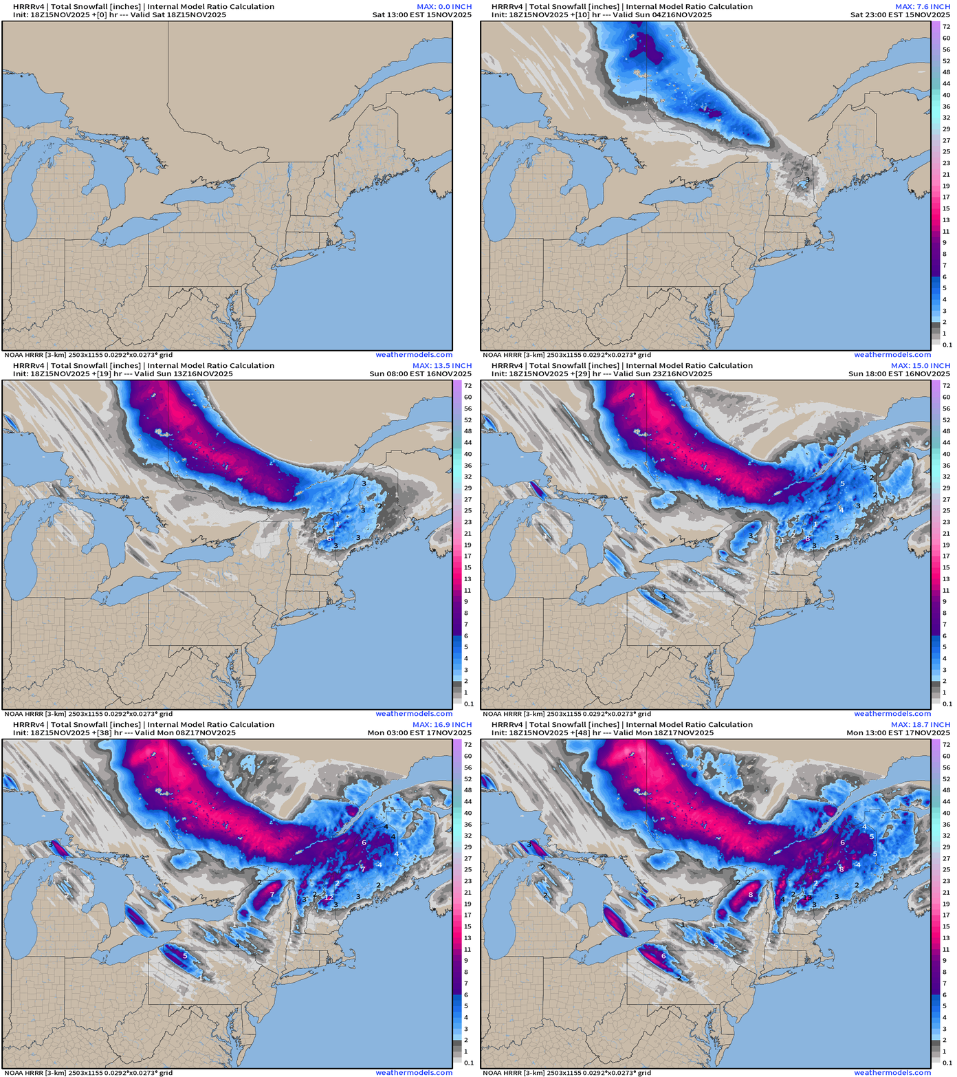
Quite the paint brush of snowfall across Quebec, but also coming off the Great Lakes — what a spectacle for Nov 16-17, already shoveling heavy, wet snow.
HRRR Precipitation | Next 48-hours | Through Monday Afternoon
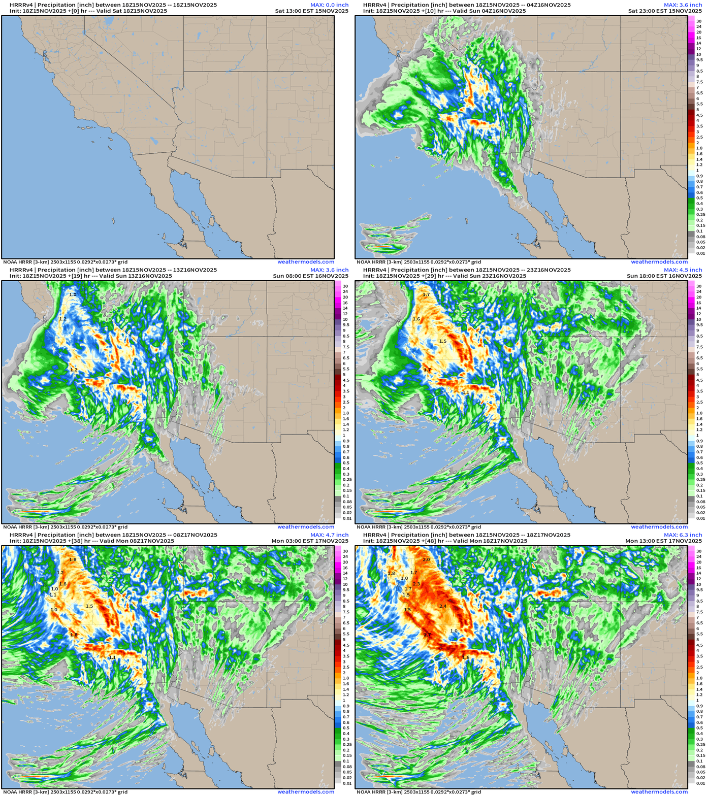
Amazing period of onshore flow + atmospheric rivers = boatloads of rainfall continuing into early week
Total Rainfall | NOAA WPC | Next 7-days
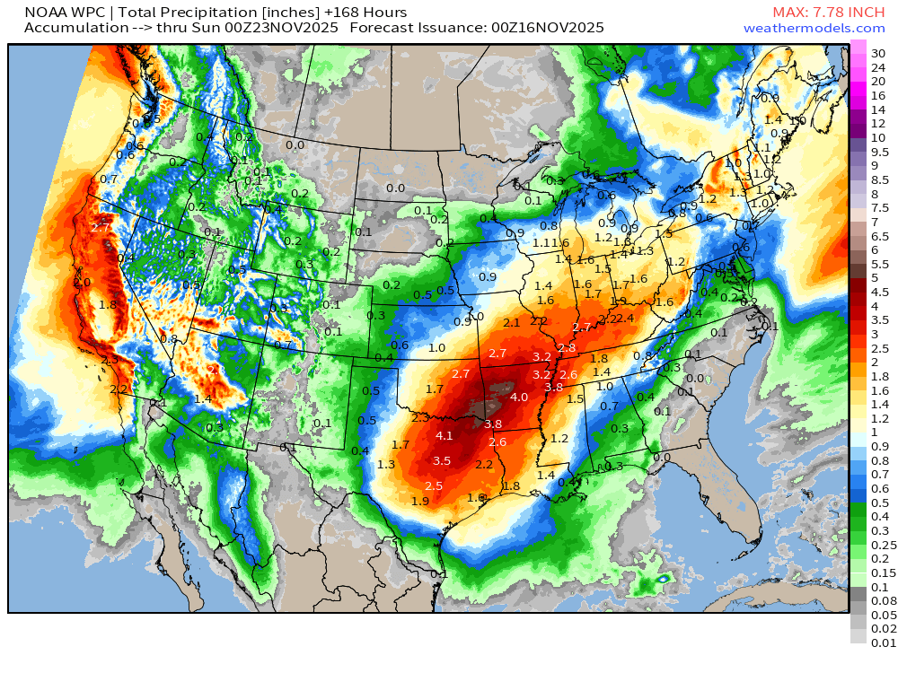
Texas: 7.2 Trillion gallons of rainfall in next 7-days. Arkansas: 3.6T. Florida: 0.03T
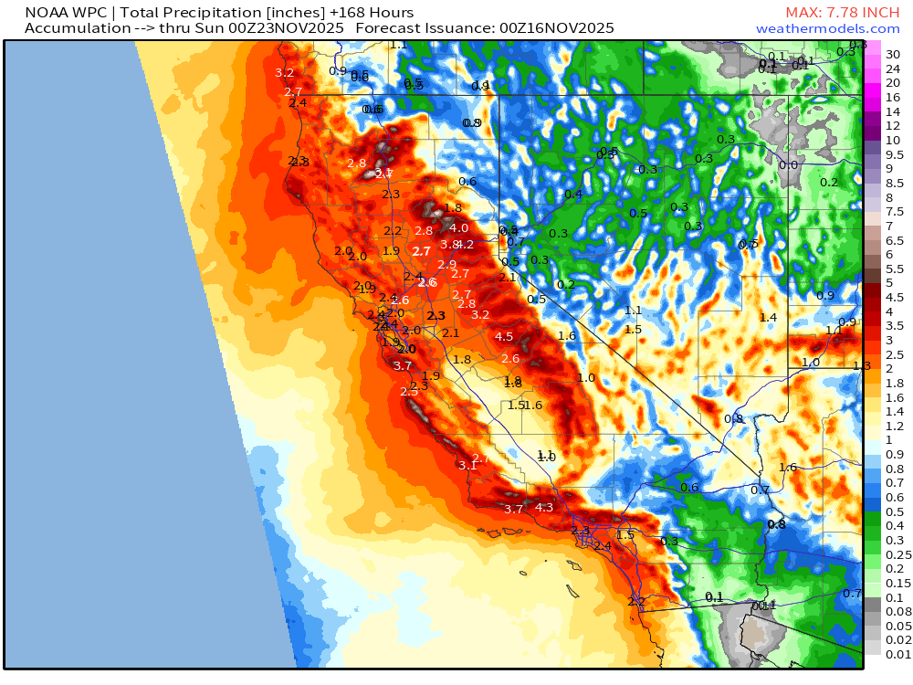
Widespread California rainfall — another 6.4 trillion gallons forecast during next 7-days out of a Lower 48 total of 51.5 trillion gallons.
Temperature Analysis | 6:00 PM ET
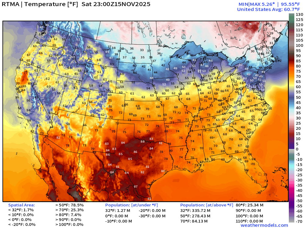
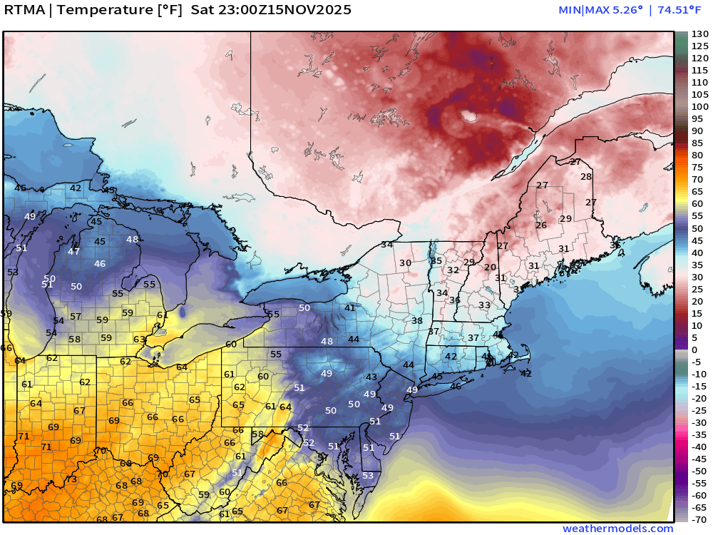
Chilly across New England … below freezing for 1.3 million population
Temperature Anomaly | 6:00 PM ET
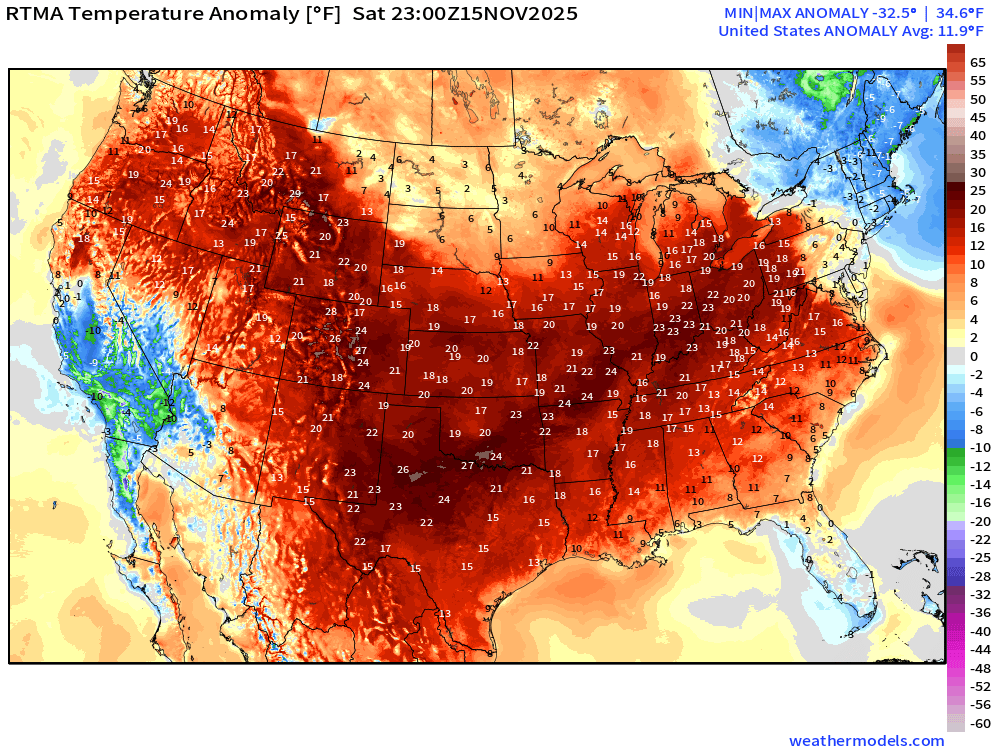
Lower 48 Temperature Anomaly was HUGE 11.9°F above normal
ECMWF Precipitable Water Next 6-days
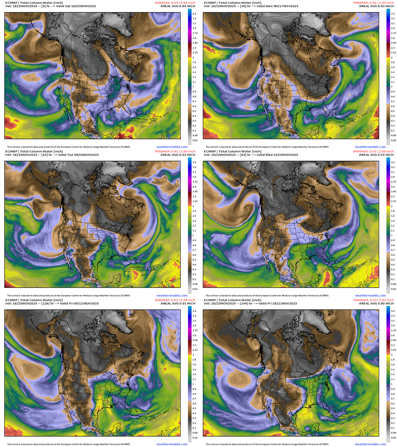
My favorite parameter! Complicated mess of circulations off U.S. West Coast will continue to send atmospheric rivers into California.
Gulf of Mexico moisture plume activated by approaching cut-off low and surface storm system developing in Texas and Central Plains —> Severe Weather Event Thursday-Friday.
Cold, dry air continues to sideswipe the Northeast with reinforced troughing.
Integrated Vapor Transport | Next 10-days ECMWF 12Z
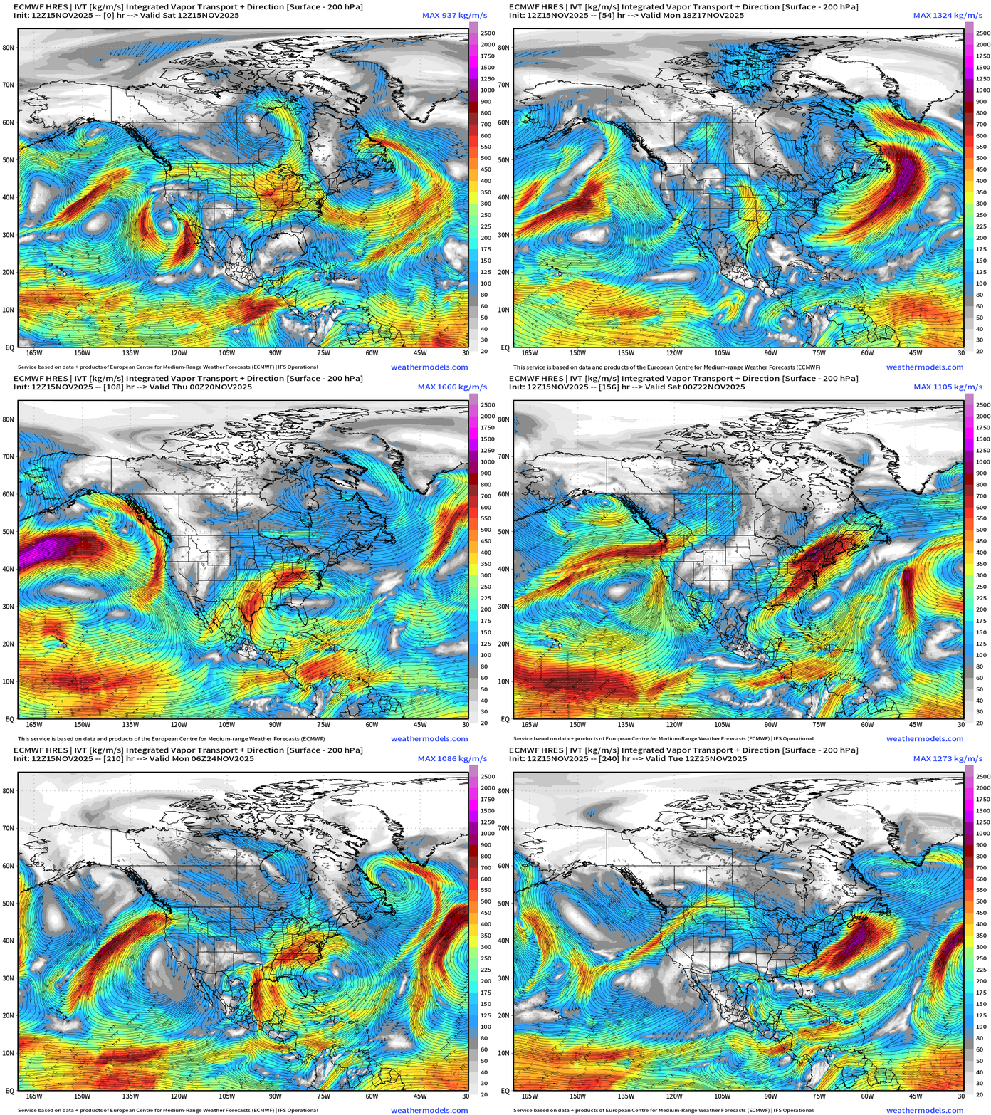
IVT highlights atmospheric rivers of moisture in the atmosphere — and we typically look at the U.S. West Coast … but also works elsewhere, including the East Coast.
Huge influx of moisture into Texas/South from the Gulf of Mexico into middle of next week — showing up on the precipitation total maps (earlier) — maybe setting the stage for a coastal storm off the Northeast in the Day 10 range …
ECMWF AIFS 12z | Height Anomaly (500 hPa) Next 10-days
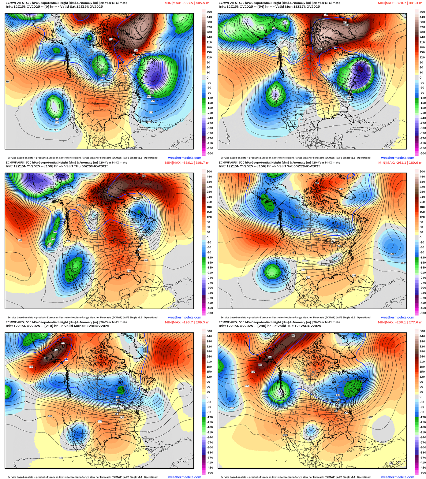
Quite the major trough intensifies over the Northeast into Mon/Tues before finally weakening and giving way to ridging from the west — warming temperatures.
The cut-offs along the West Coast are repetitive — and as they slide eastward through the Southwest into Texas — provide cyclonic flow to bring up warmer, moister air out of the Gulf of Mexico.
ECMWF 18z | Snowfall | Next 6-days
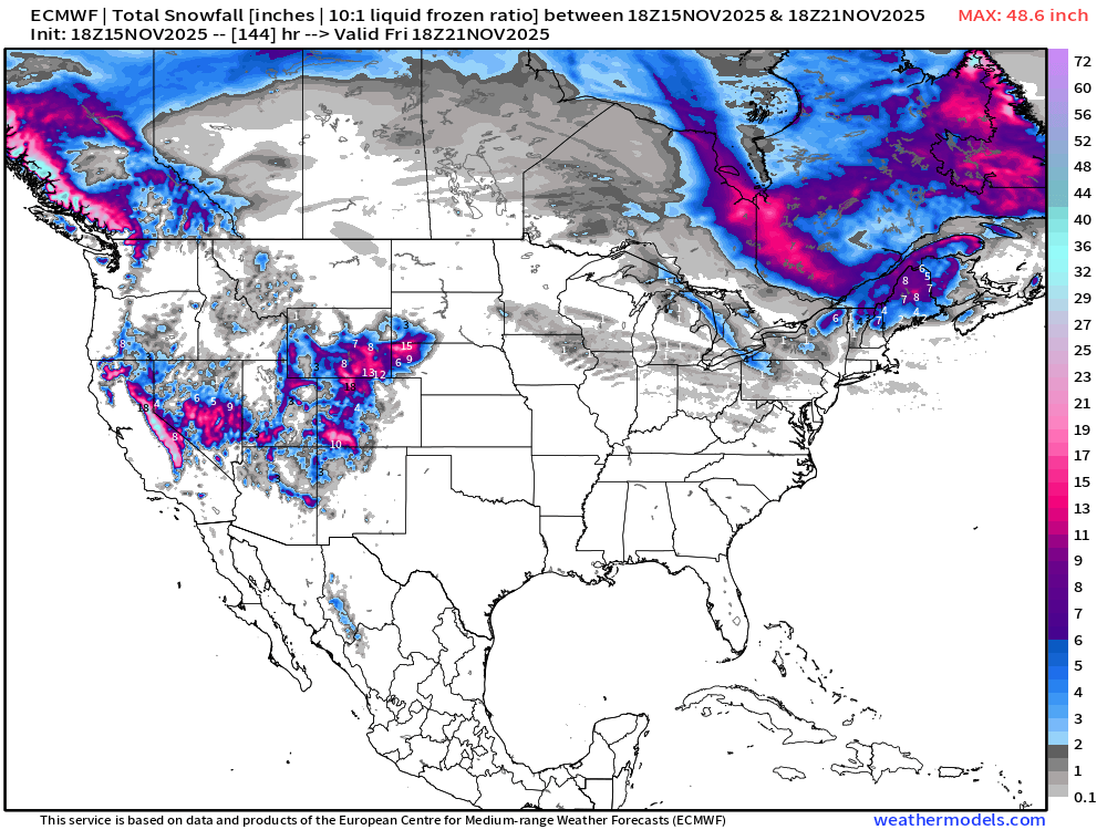
Nice to see healthy snowfall into the Rockies including Colorado and Wyoming for the skiers.
ECMWF EPS 12z | Ensemble Median Snowfall Next 15-days
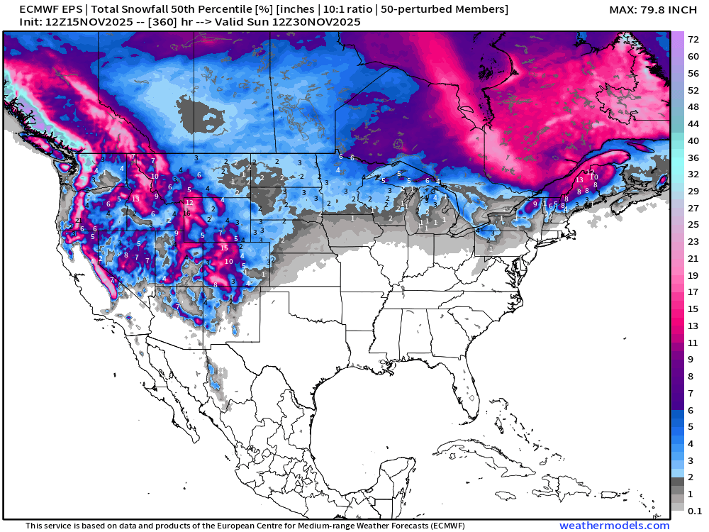
ECMWF EPS 12z | Ensemble Snowfall Probability > 3” | Next 15-days
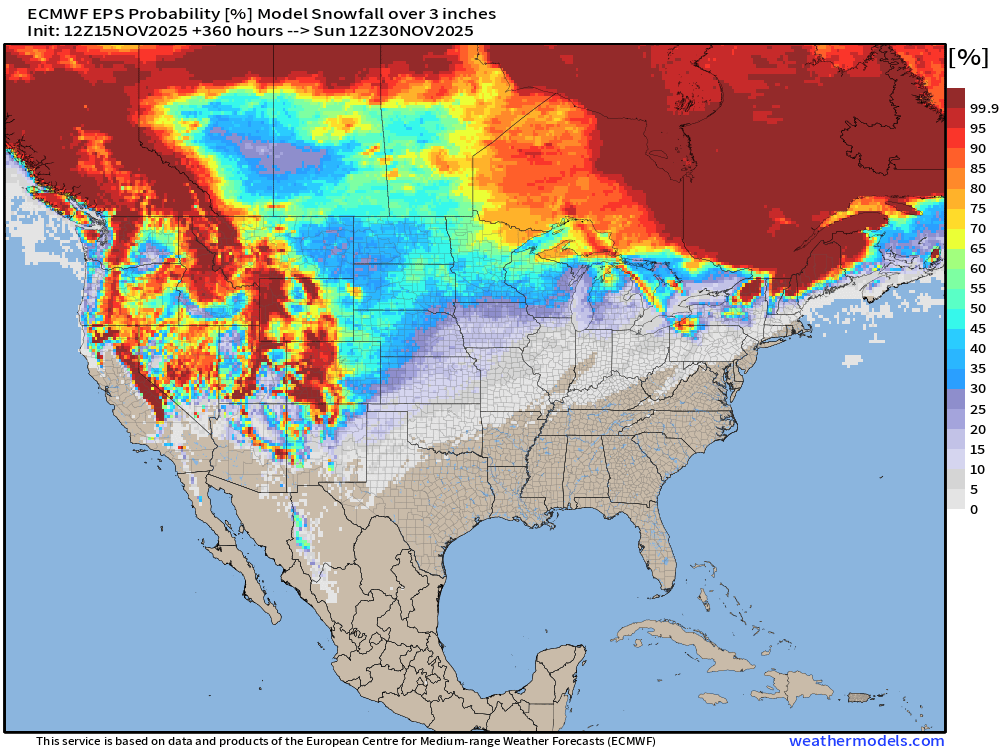
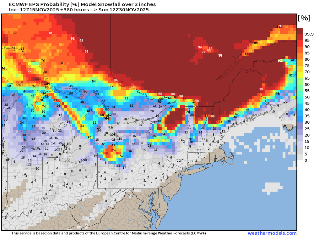
Total for the next 15-days from the flagship ECMWF ensemble model shows nationwide snowfall but still lacking a major East Coast Nor’easter
Total Precipitation | Median of Ensembles Next 15-days
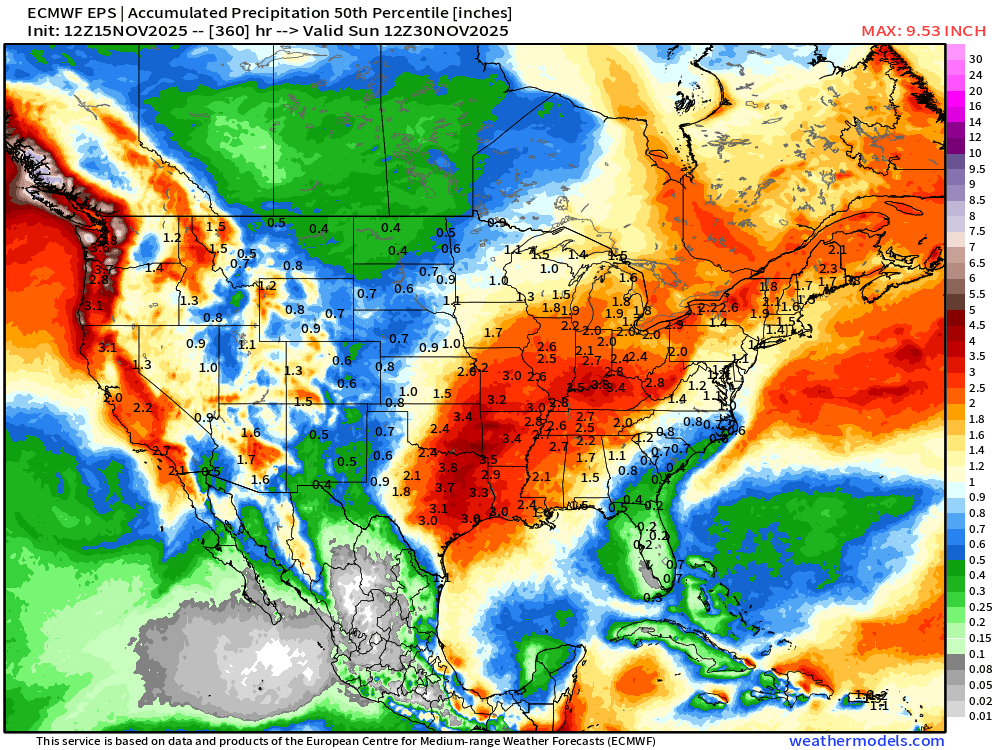
Florida = dry while the central U.S. from Texas into the Ohio Valley = wet pattern, but also warm
Sunday Morning Lows
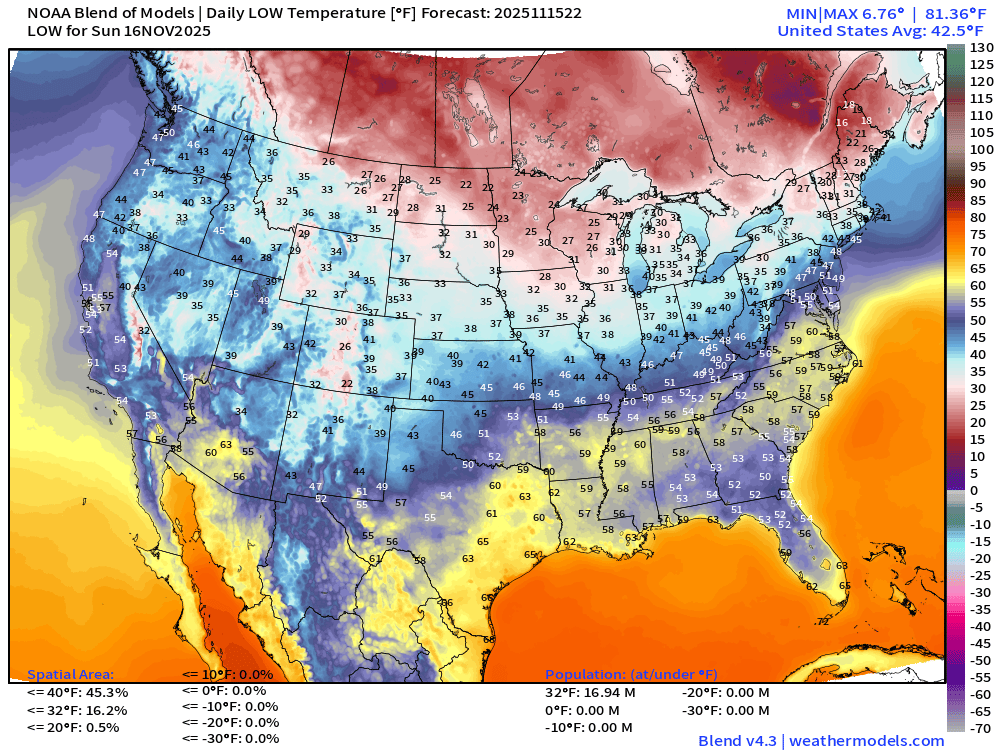
17million below freezing or about 10% of the U.S. population
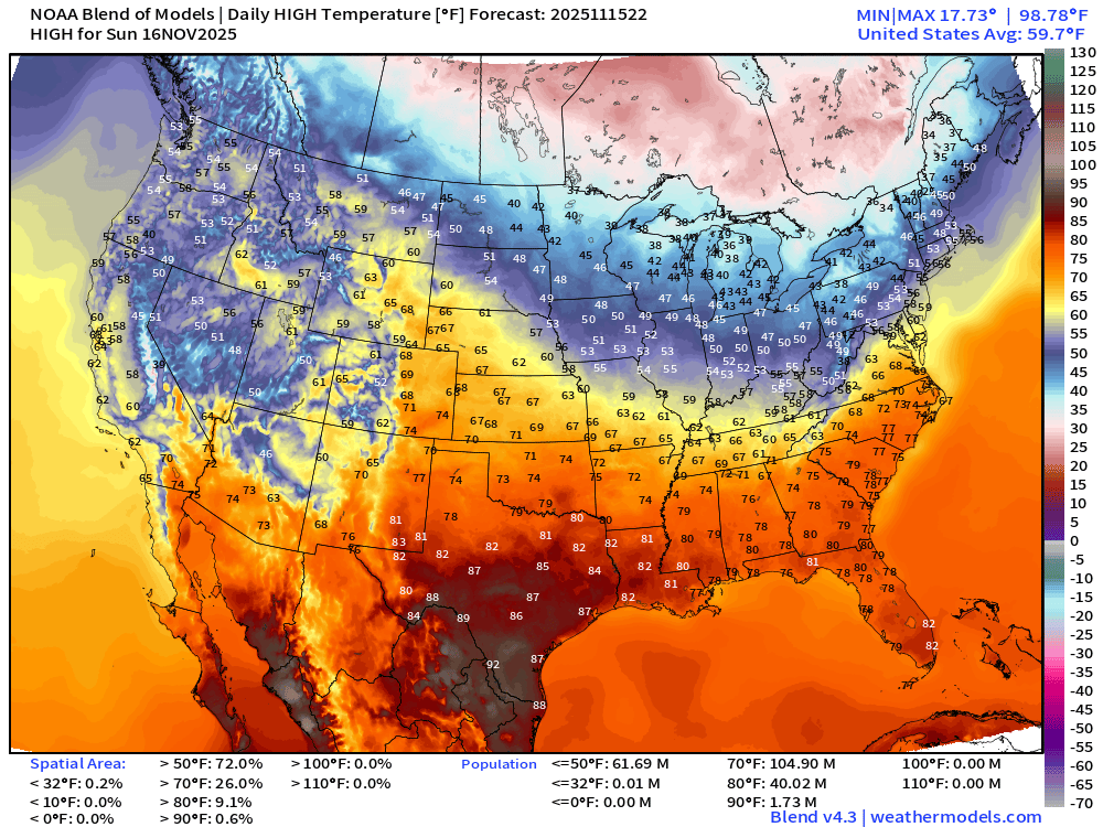
High Temperatures Sunday
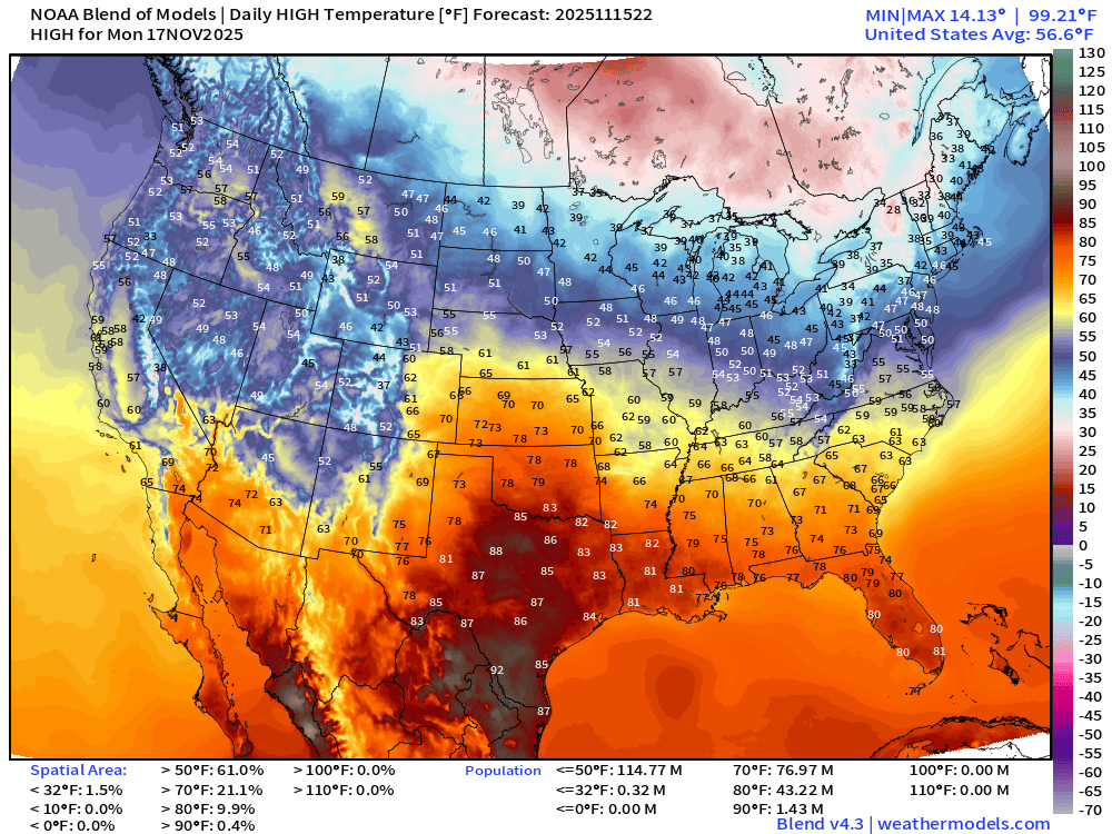
High Temperatures Monday
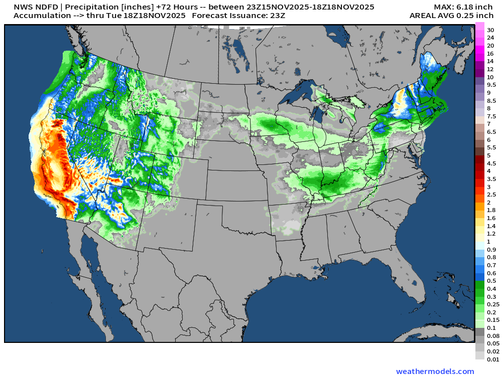
NWS Precipitation Next 72-hours
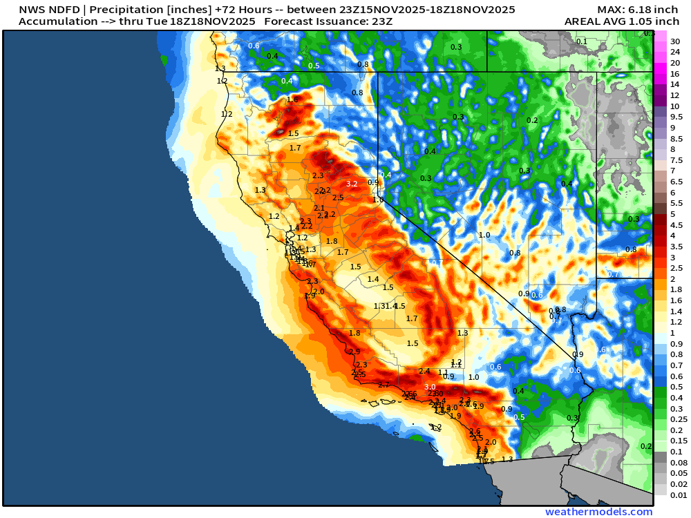
HUGE rainfall totals in California from atmospheric rivers
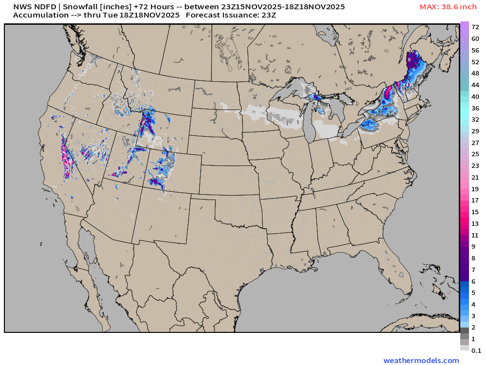
NWS Snowfall Next 72-hours
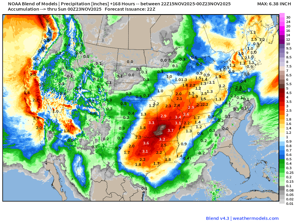
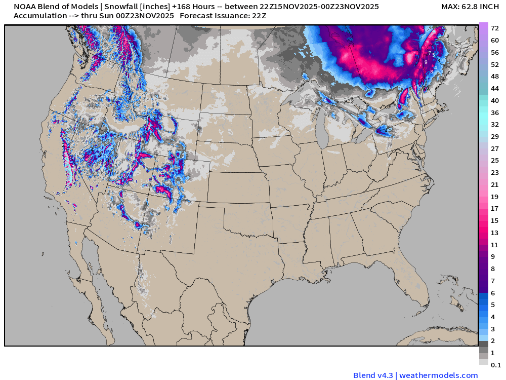
Blend of Models | 7 Days Precipitation and Snowfall Totals
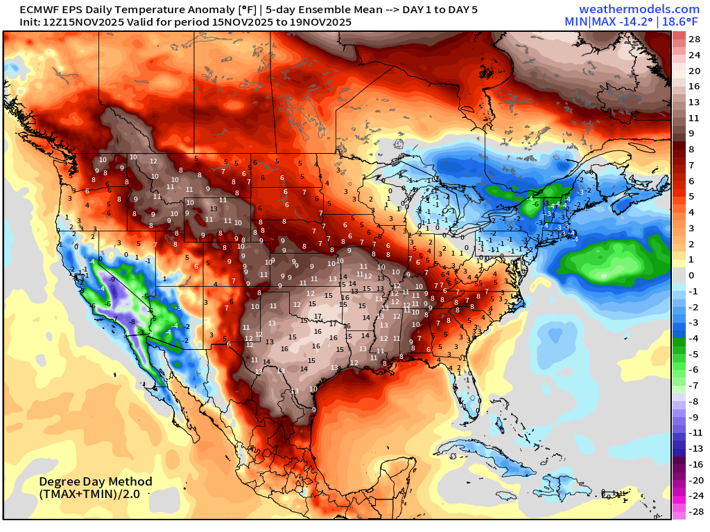
5-Day Chunk #1 | Temperature Anomaly | Nov 15 - Nov 19
5-Day Chunk #2 | Temperature Anomaly | Nov 20 - Nov 24
5-Day Chunk #3 | Temperature Anomaly | Nov 25 - Nov 29
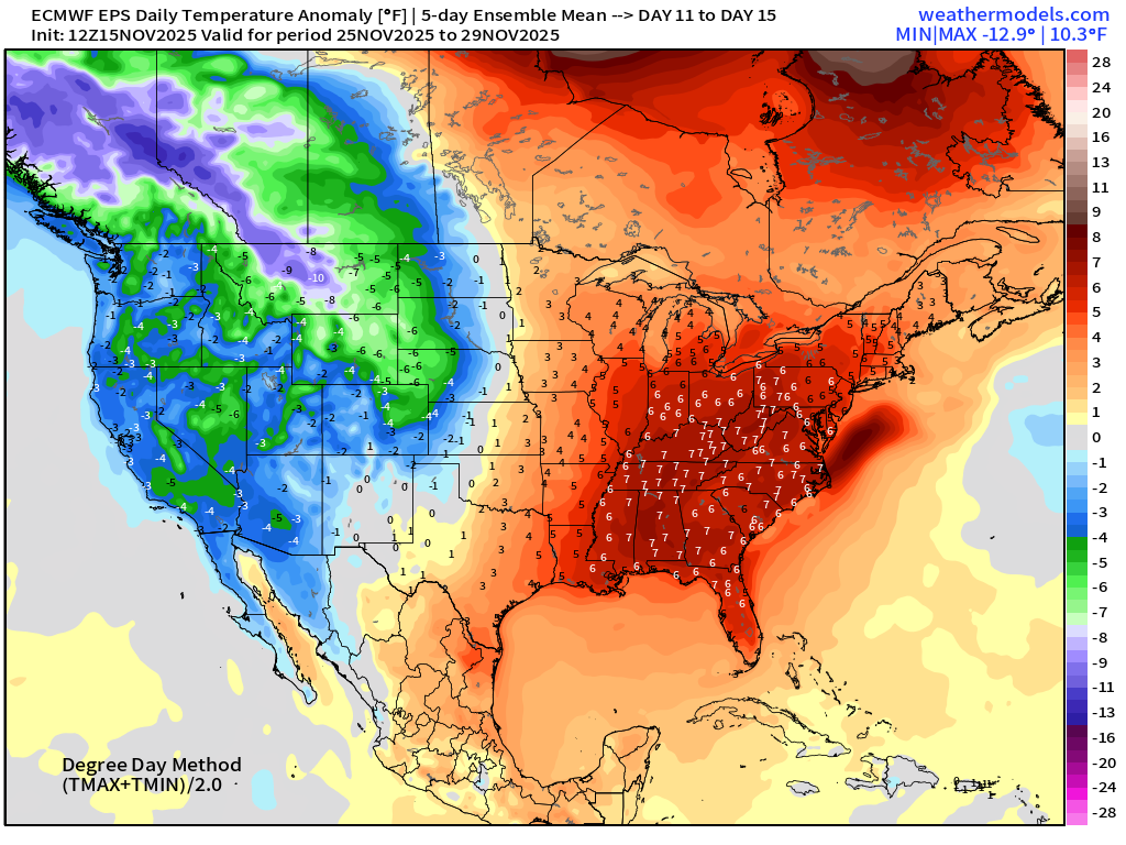
Widespread warmth overtakes the entire Eastern U.S. into Thanksgiving? Western U.S. goes cold — great new for the ski resorts — potential for extreme cold increasing.
Atlantic Hurricane Season Statistics | November 15, 2025
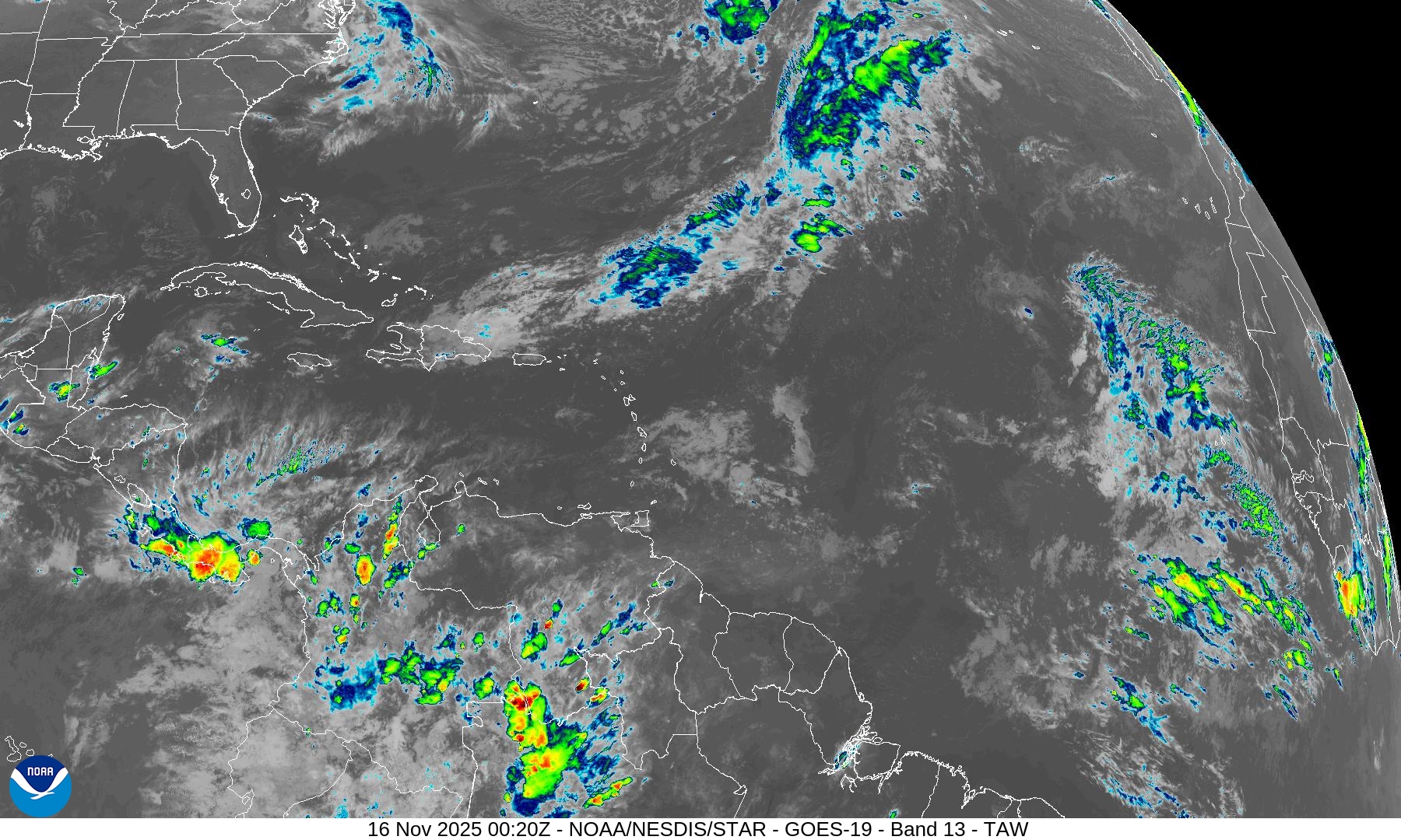
Nothing brewing in the next 7-days —> November 20th according to NHC. Not seeing anything in the ensembles through Nov 26th — high likelihood that the 2025 season is complete, ending with Melissa.
2025 Hurricane Season [Day 168]. My FORECAST for this year was 14 named storms, 7 hurricanes, and 3 major hurricanes (near average)
2025 Season to Date: 13 Named Storms, 5 Hurricanes, and 4 Majors, and 3 Category 5’s | Accumulated Cyclone Energy (ACE) = 135.5
Atlantic Basin | IR Satellite
8-Day Tropical Outlook —> ECMWF EPS 12z | Active Tracks
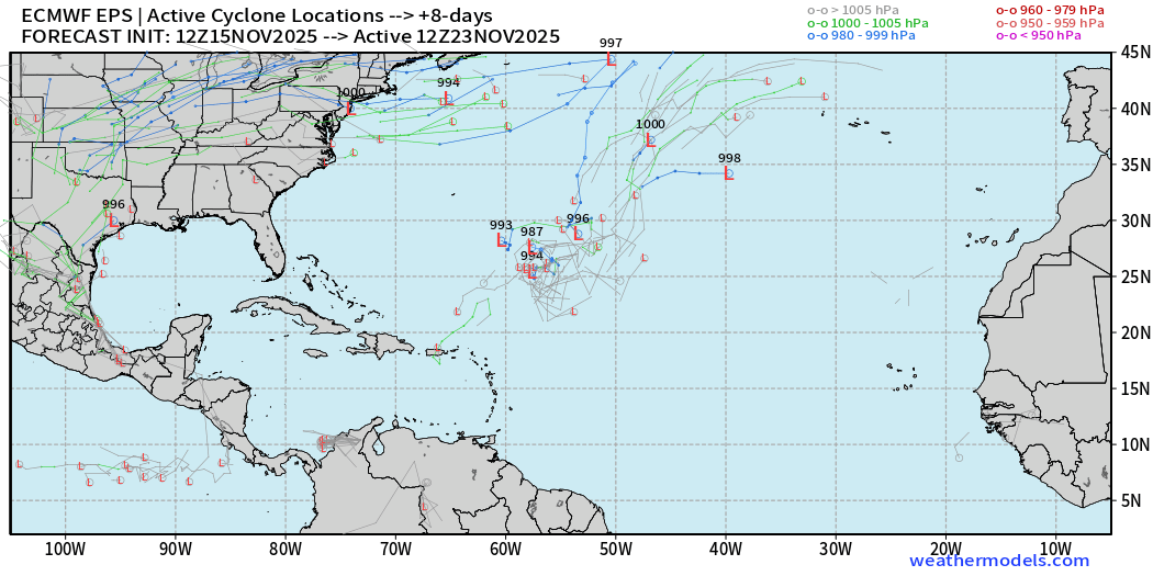
Interesting subtropical lows SE of Bermuda — worth watching as a piece of the Polar Vortex well to the north is pinched off as a cut-off low, and then circulates clockwise around the basin. Low, low chances, but not zero!
All tracks thru 15-days: November 30th — end of the road —> QUIET
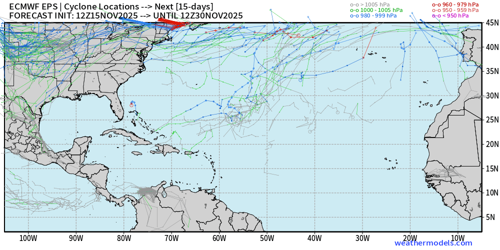
Nothing brewing in the 2-week ensemble tracking —> dead quiet. We’d look at the far southern Caribbean, but not seeing anything.
Maps sourced from weathermodels.com designed and innovated by yours truly! Please subscribe there for real-time access to the newest maps, charts from all of the weather models including ECMWF.
- Milepost
- 790 · laid 2025-11-16T00:37:43.074000Z
- Source
- https://weather.substack.com/p/november-15-2025-saturday-weather
- Digest
- d7ae74449ce3c05ea7a9ac8cad7f48cb614a36441385c7bc75be3b08650b6d72
- Machine
- JSON