April 2, 2026 Thursday Spring Weather
Two storm systems will have severe weather as well as heavy snow
April 2026 was the 3rd-warmest April in the 132-year national record (1895–2026), at 54.7°F against a 1991–2020 normal of 51.8°F (+2.9°F).
April 2026 was the 46th-wettest April in the 132-year national record (1895–2026), at 2.7in against a 1991–2020 normal of 2.7in (+0.0in).
NOAA/NCEI Climate at a Glance, contiguous United States. This is the observed record for the month, not a score of anything said in this piece — the forecast ledger begins 2026-08-17 and cannot reach earlier posts.

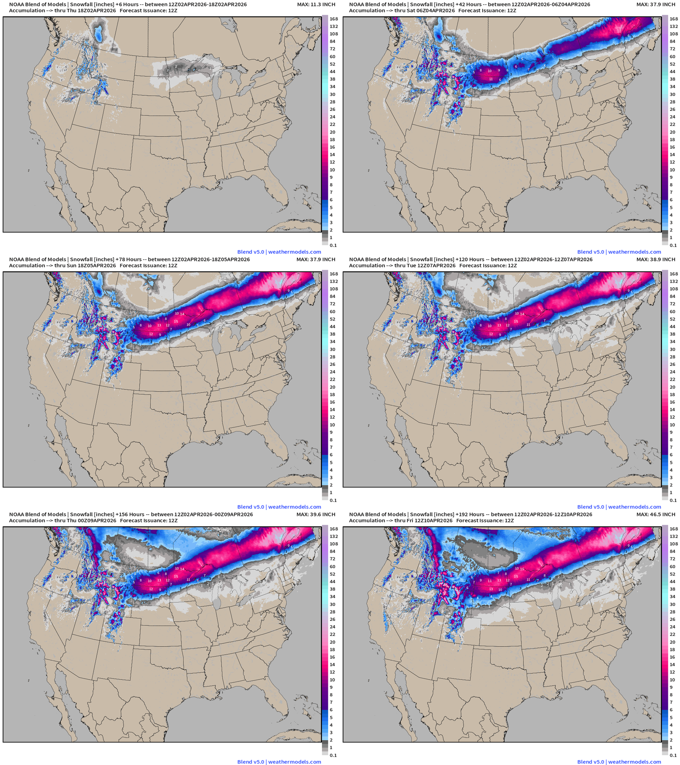
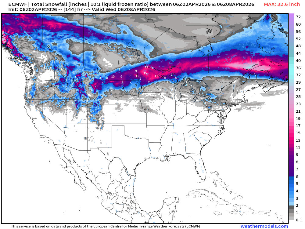
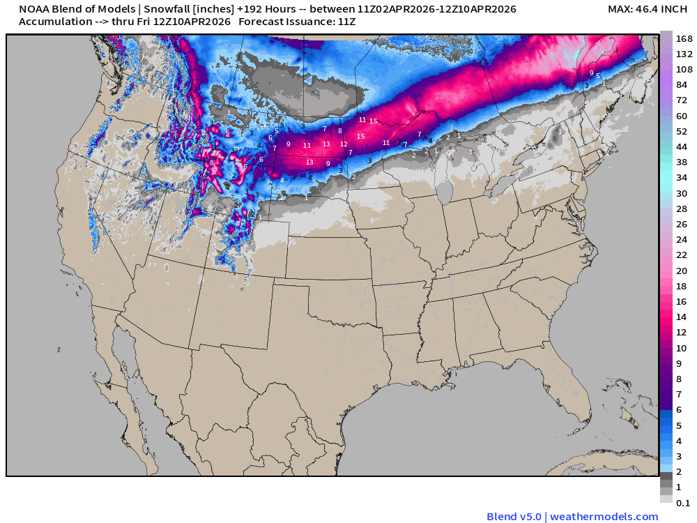
Two storms systems back-to-back will have plenty of cold air to work with on the backside of the low-pressure centers = heavy accumulating snowfall in a band from the Dakotas into Ontario and Quebec. Colder air with a trough in the Pacific Northwest moving through northern Rockies = plenty of very welcome mountain snow. Blend of Models (new Version 5.0) Snowfall next 8-days
Weather Trader is an entirely reader-supported publication. To receive all new posts [daily] via email or the Substack App, and support our work, consider becoming a paid subscriber (April Coupon) — ALL content is generated by Ryan (not A.I.) including the maps. Thank you to new (and renewing) subscribers in March (free and paid) who support this newsletter and development behind the scenes.
Weather/Fronts Today into Thursday morning
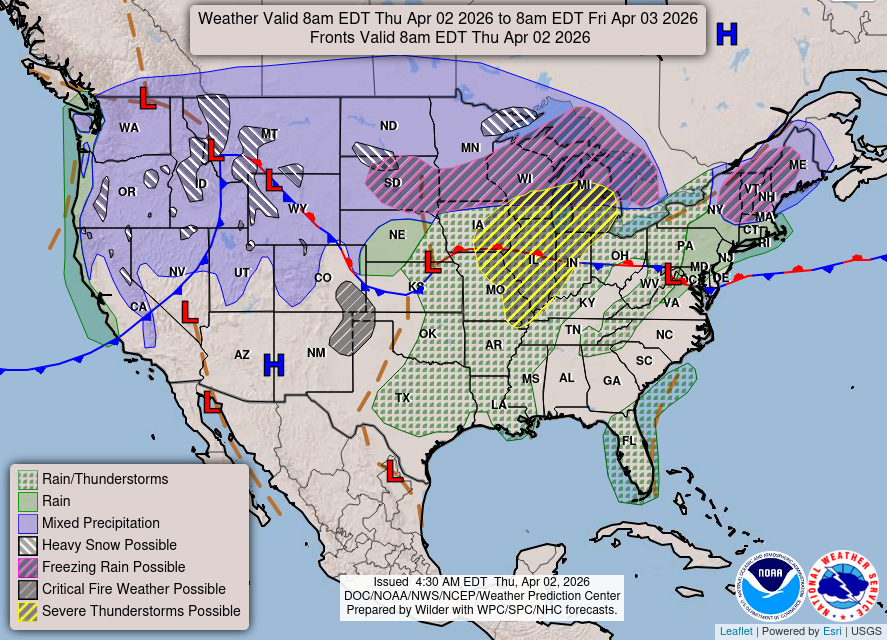
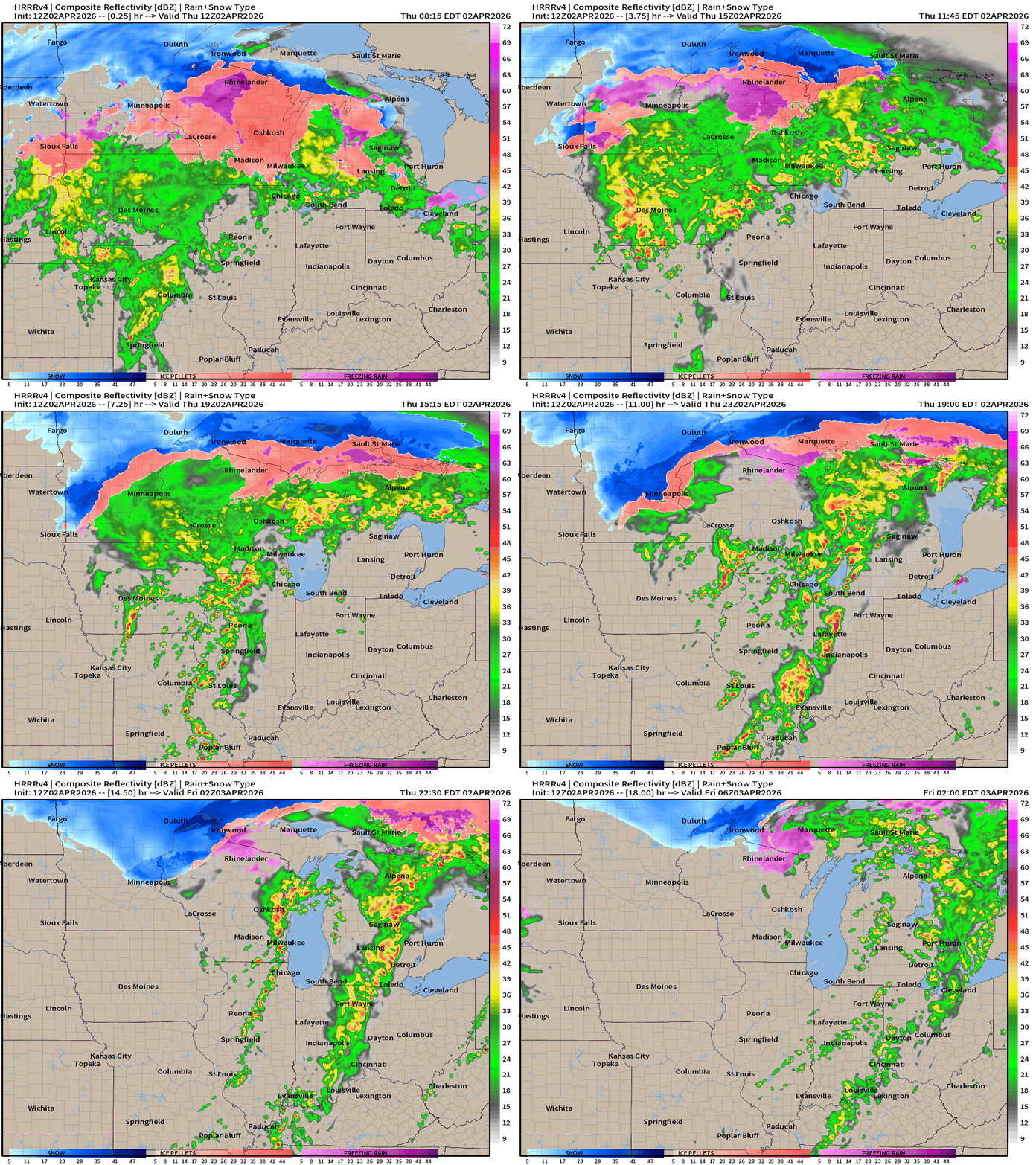
Today: Enhanced Risk of Severe Weather including Chicago (12.5 million pop)
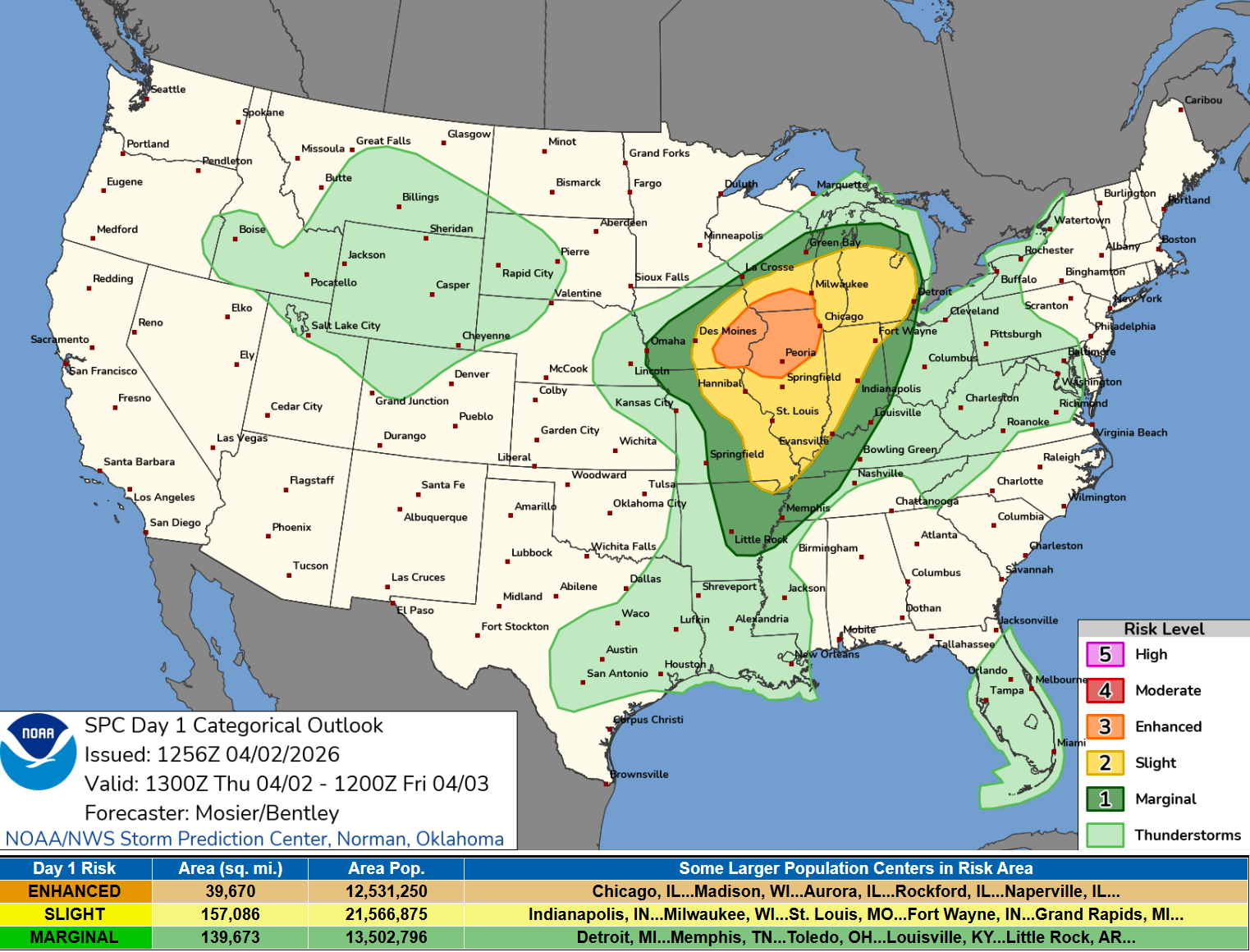
   From SPC Day 1 Convective Outlook
   Severe thunderstorms capable of producing a few tornadoes appear
   probable across parts of eastern Iowa, northern Illinois, and
   southern Wisconsin this afternoon. Additionally, damaging
   thunderstorm winds will be possible from eastern Iowa northeast into
   Michigan.
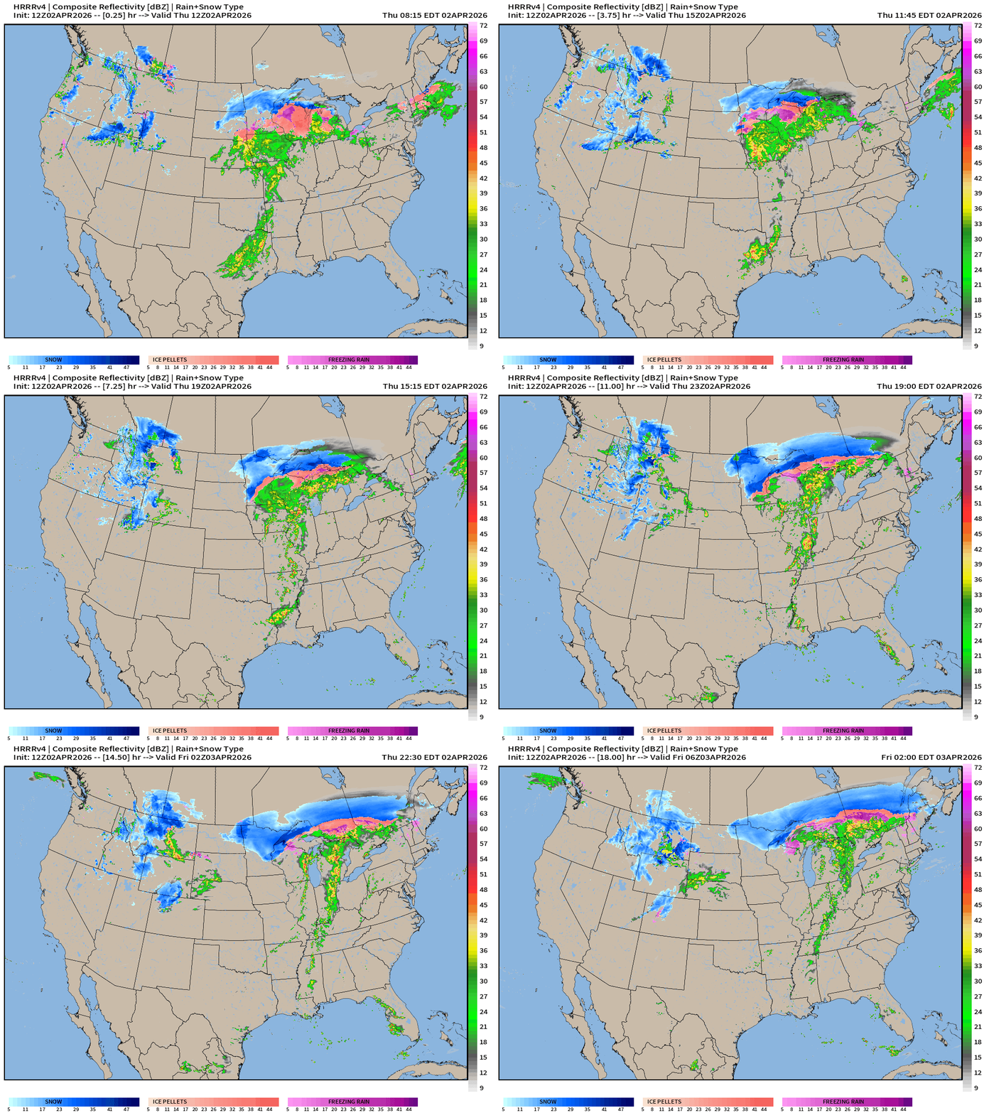
HRRR 12z Radar Simulation next 18-hours into Friday morning 2 AM ET
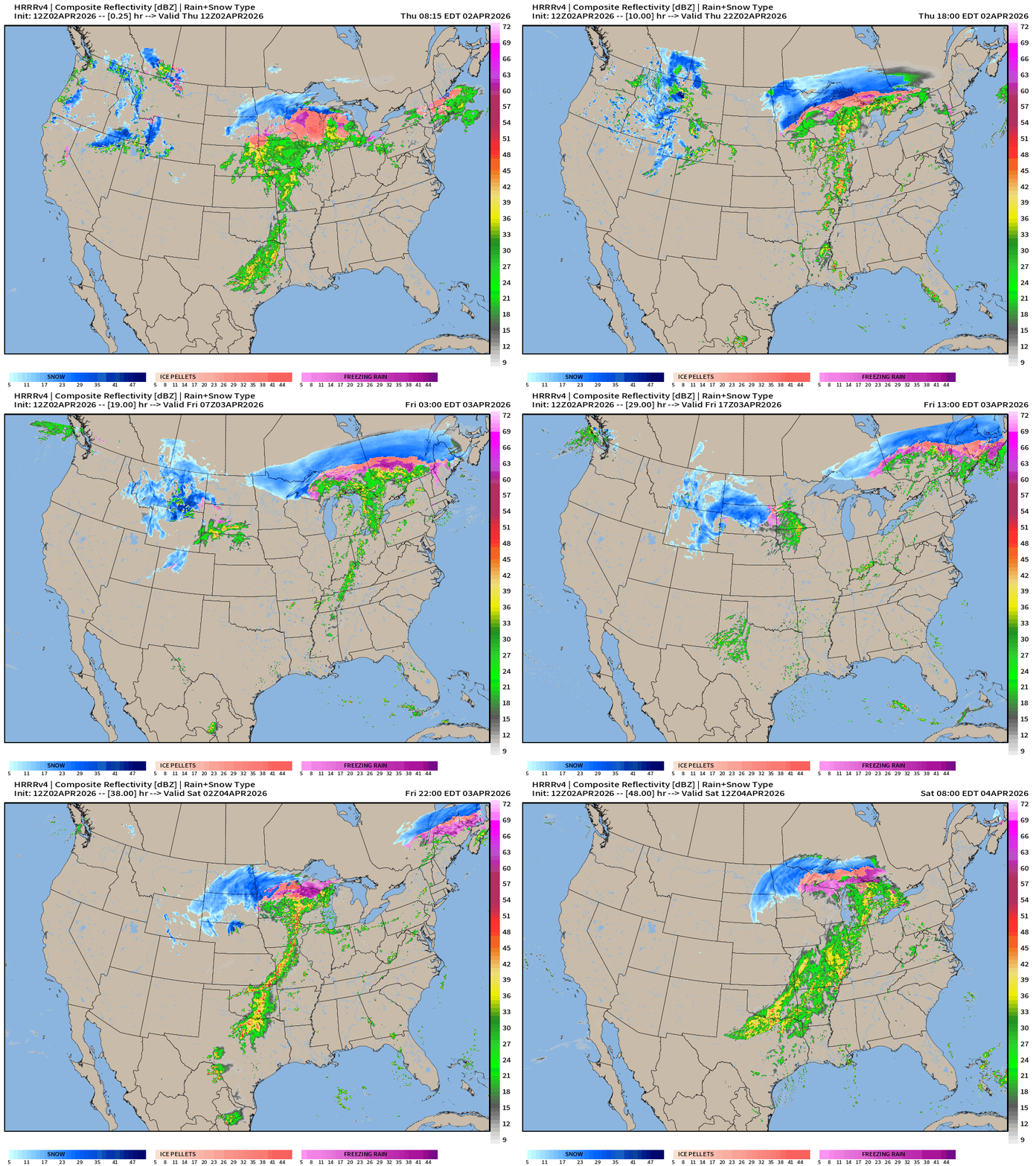
HRRR 12z — Radar Simulation Next 48-hours to Saturday 8 AM ET
Weather on Friday into Saturday Morning (Storm system #2)
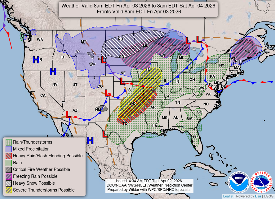
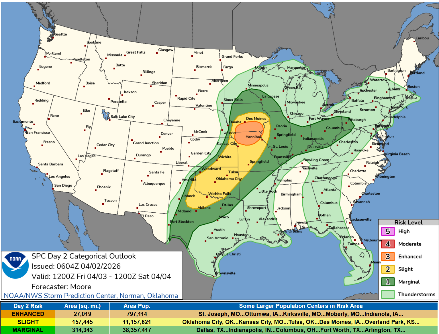
   From SPC Day 2 Convective Outlook
   An extensive squall line may develop across parts of the east
   central Great Plains late Friday afternoon, and perhaps become
   capable of producing widespread strong to severe wind gusts and a
   risk for tornadoes while advancing toward to the middle Mississippi
   Valley and southeastern Great Plains through Friday evening.
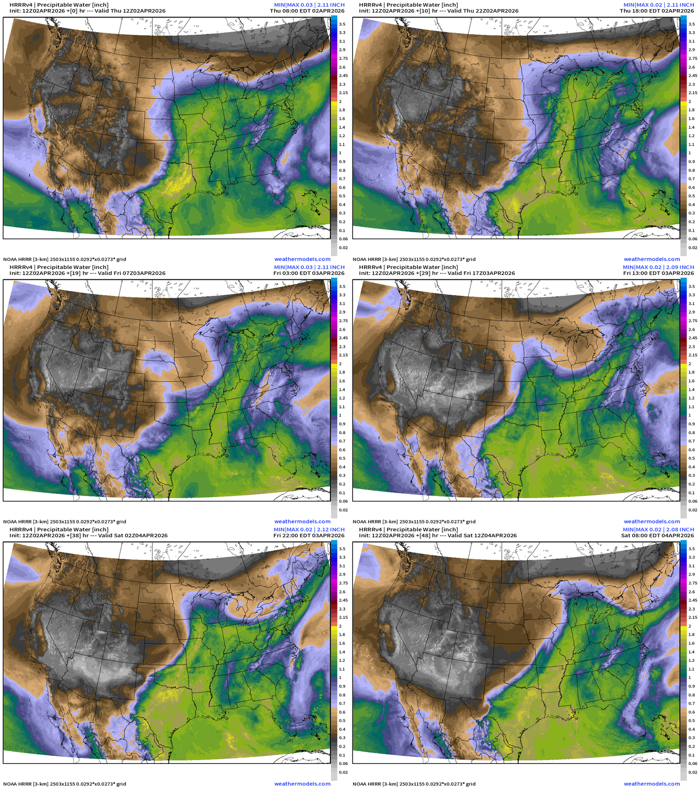
HRRR 12z Precipitable Water Next 48-hours (my favorite parameter)
ECMWF 06z | Forecast model 6-days of Precipitable Water (my favorite parameter)
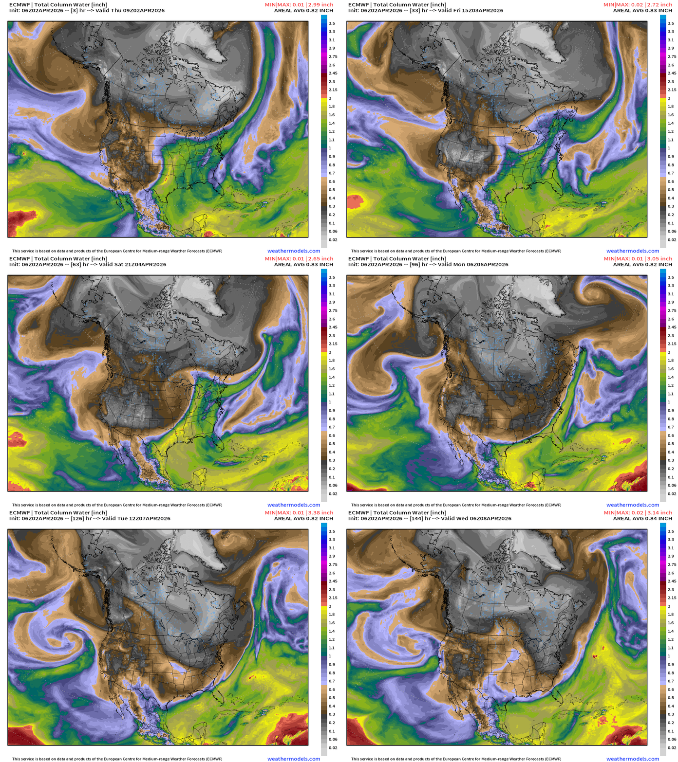
Two powerful storm systems (today and this weekend) … but the second one has a major cold front and mini-blast of Canadian Arctic air behind it — sweeps through the Southeast (not quite Florida)
ECMWF 06z Precipitation Type + Intensity | Next 6-days
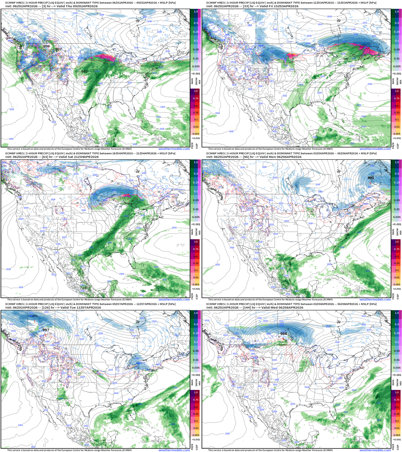
Two major storm systems typical of Spring severe weather season — but still exceptionally cold air from the “Polar Vortex” in Canada available heavy snowfall on backside of lows in Midwest and northern Great Lakes
Low pressure forms in next 24-hours in lee of Rockies in Colorado and tracks into the Great Lakes … pressure falls into the 990s. Wintry precipitation north of the warm front in the much colder Canadian air + rain and severe weather ahead of cold front in Warm sector
Second powerful low follows into the Great Lakes on Saturday and Sunday with severe weather along cold front and in the warm sector. However, the low does not look to organize until it reaches well into Canada, perhaps limiting the overall severe wx impacts.
RTMA Current Temperature Analysis | 9:00 AM ET
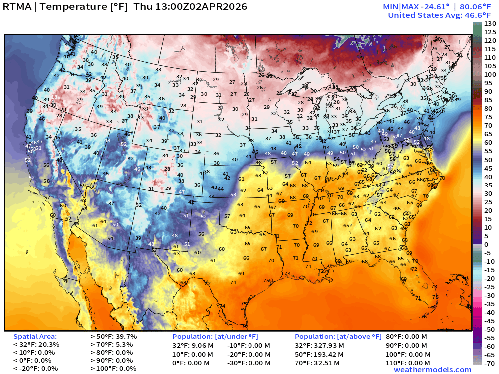
Lower 48 average was 46.6°F with only 9 million population below freezing
RTMA Current Temperature Anomaly Analysis | 9:00 AM ET
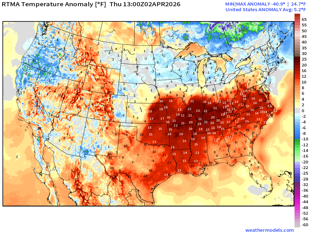
Lower 48 was 5.2°F ABOVE normal
Wednesday Analysis | NOAA GFS Model
A look “current analysis” or “monitoring the situation” from the same model output used to generate the forecast animations. Precipitable Water is my favorite parameter: measure of the total moisture in the atmospheric column and nicely highlights polar air, frontal boundaries, and tropical plumes or atmospheric rivers.
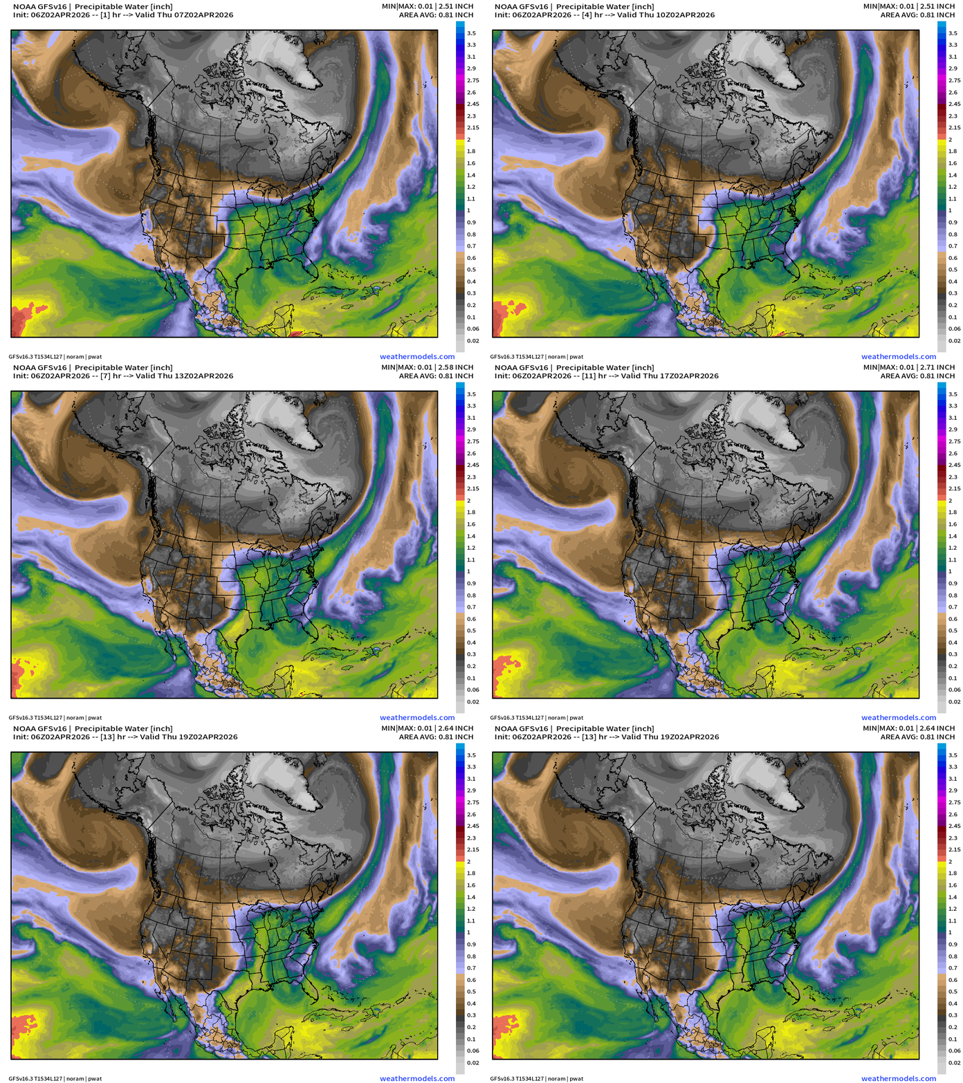
Major trough moving through the Pacific Northwest with cooler air … The eastern U.S. is under control of a large scale ridge bringing warm, moist air out of the Gulf of Mexico ahead of today’s storm system in the Plains and Midwest to Great Lakes.
Temperature Anomaly
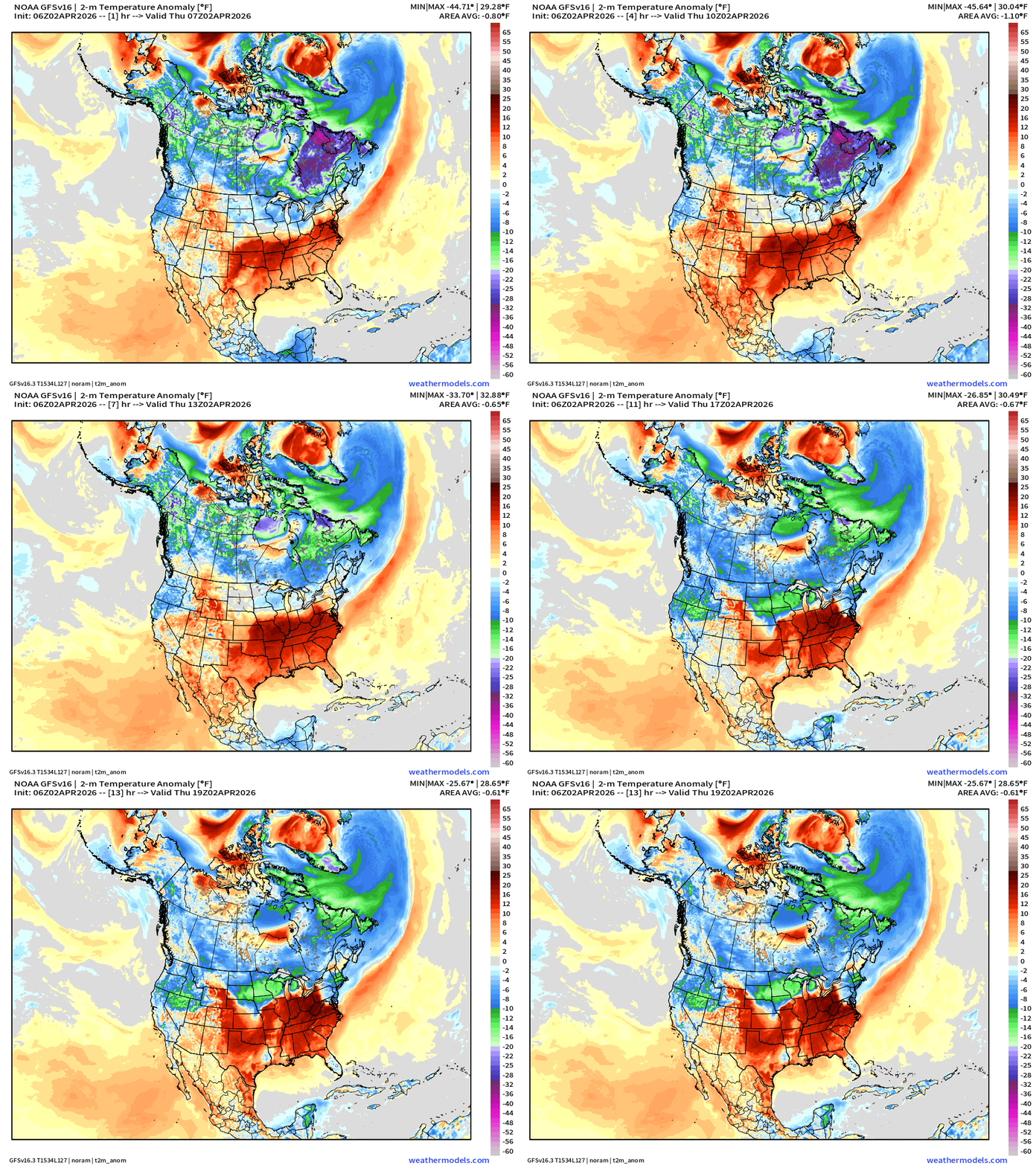
Dynamic Tropopause (my second favorite map) also highlights the air masses at upper-levels near the jet stream e.g. polar (purple + white fuzzball), and tropical (red and black) colors on the map. The super-intense PV anomaly (cyclonic/cold) has moved/stretched around Greenland forming a very powerful upper-level depression.
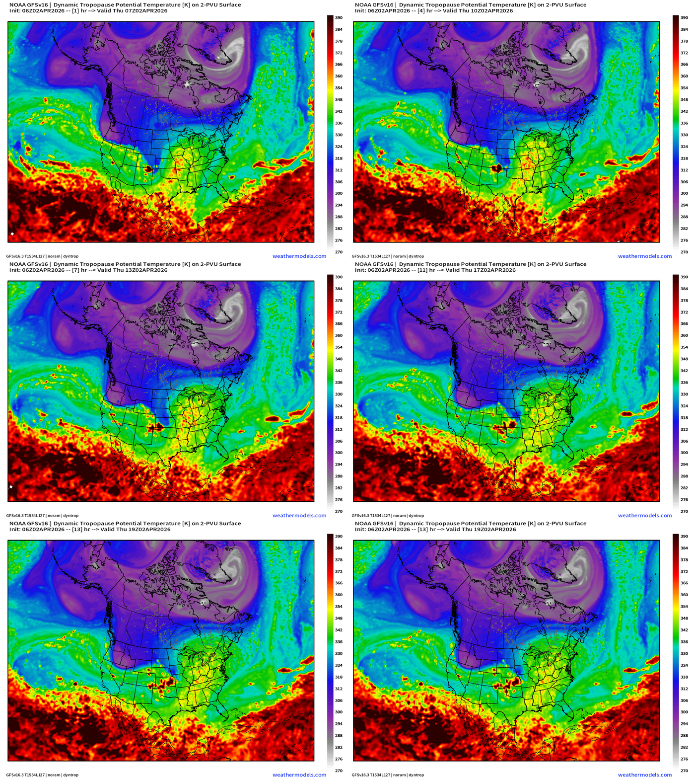
Two major PV anomalies in the pipeline (1) WA/OR into Idaho today and (2) in the Gulf of Alaska. These pockets of vorticity provide the upper-level potential energy for major storm systems across the Plains and Midwest into Spring time.
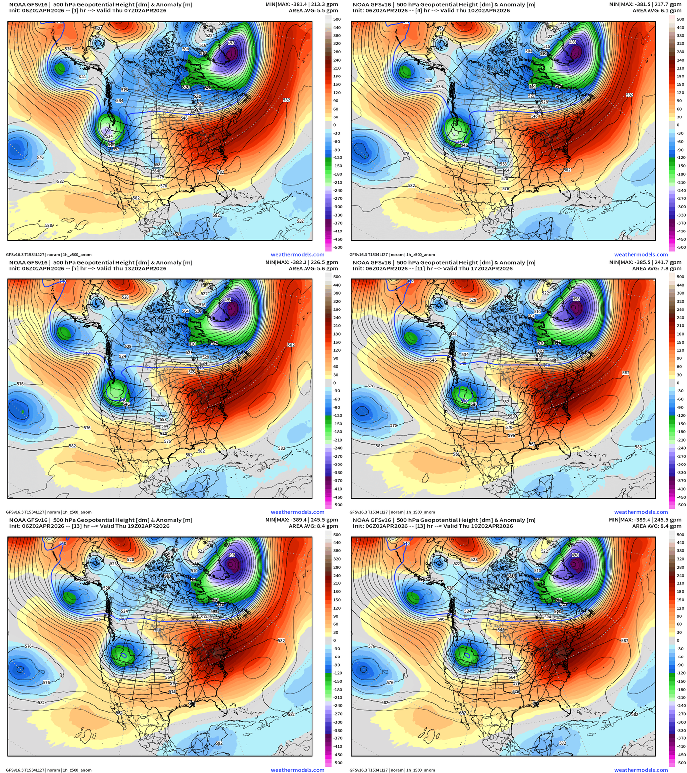
The coldest anomaly on the tropopause corresponds very strong / anomalous troughing east of Greenland. The 500 mb height anomaly shows the troughing across the Western U.S. — pattern shift (major) with ridging strongest centered over the Northeast even though temperatures will be cold in New England today.
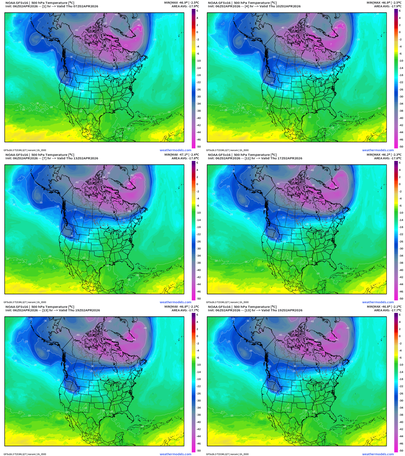
500 mb Temperature — coldest at mid-levels still blanketing much of Canada into April coldest into the -40s °C (still) but decreasing intensity. The two upper-level shortwave (PV anomaly) — one in the Gulf of Alaska and second into Idaho — are both colder than -30°C.
Finally, the Jet Stream (250 mb wind speed)
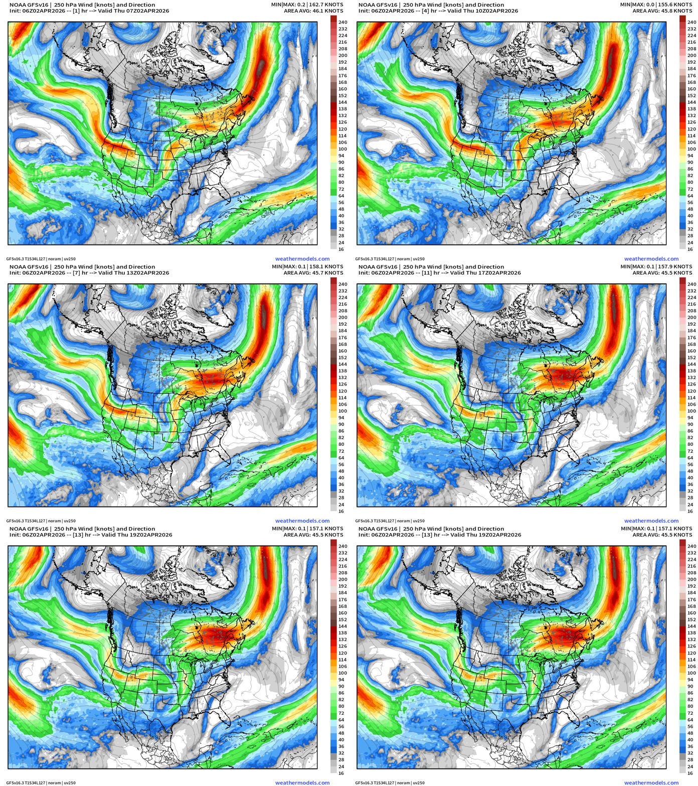
Main polar jet coming out of the Gulf of Alaska into the Pacific Northwest, then into storm system in the Midwest and Great Lakes.
Model Predictions | ECMWF AIFS 06z next 10-days of 500 mb Height Anomaly
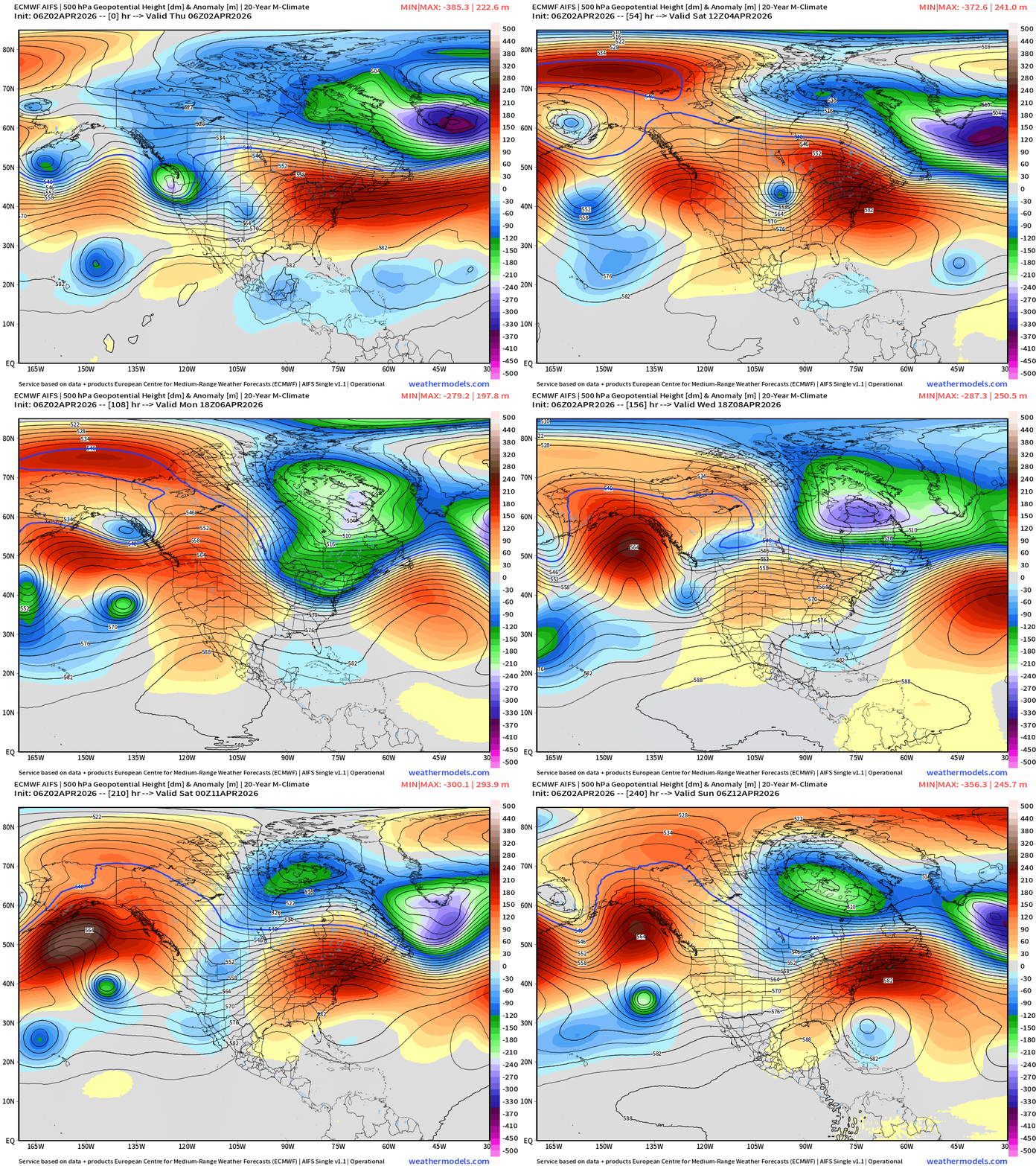
Next several days: trough in the Pacific Northwest moves eastward into the Rockies and provides the upper-level trigger for surface cyclone development into the Great Lakes. It then combines with the Canadian / Quebec main tropospheric polar vortex into a larger trough. That cold pool then dips into the Great Lakes and Northeast into middle of next week.
AIFS still shows a (blocking) ridge over the Gulf of Alaska at end of 10-day period (low predictability)
Europe’s Upper-Level Weather Pattern
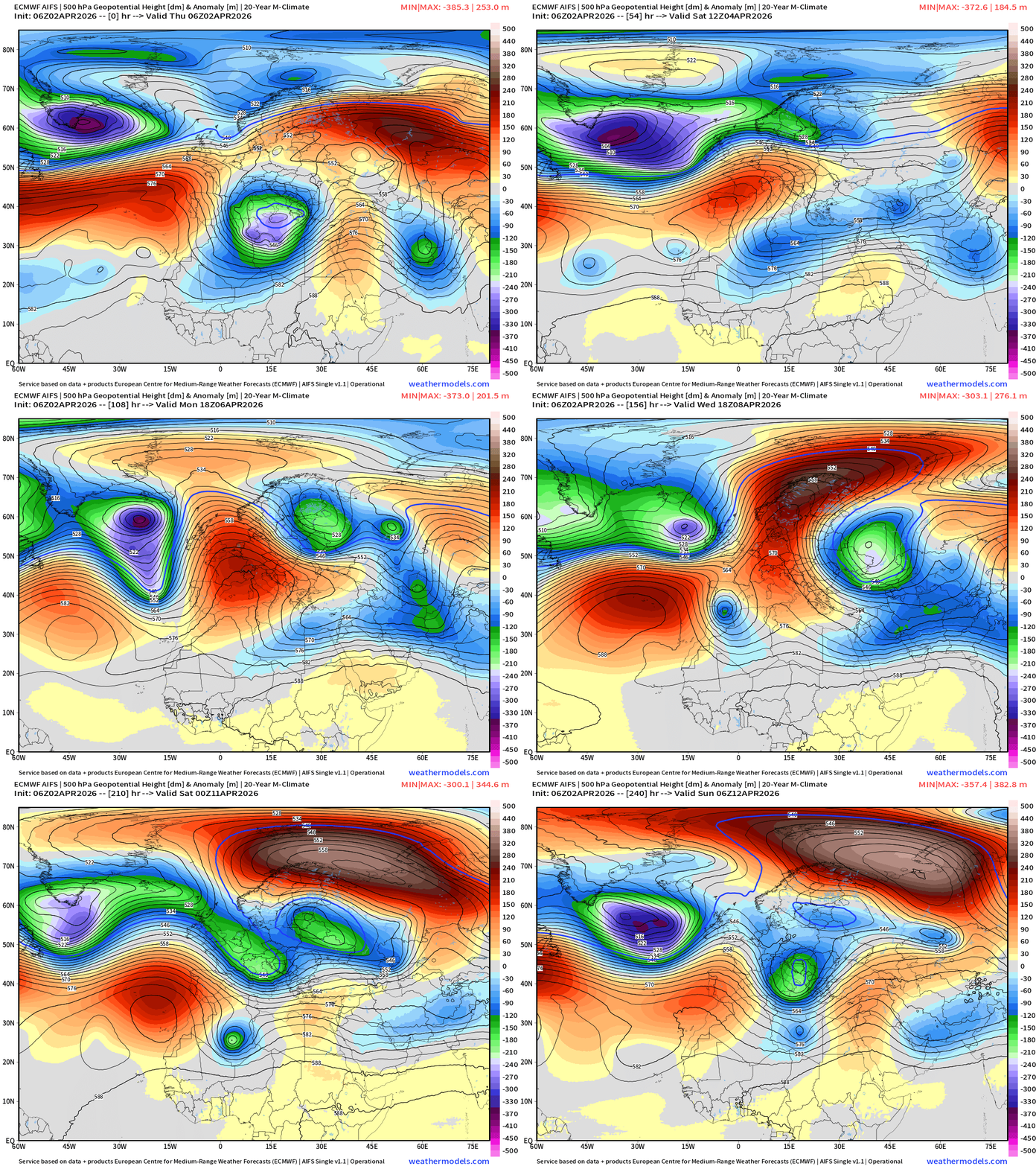
European Next 6-days | Precipitation Type and Intensity (ECMWF 06z)
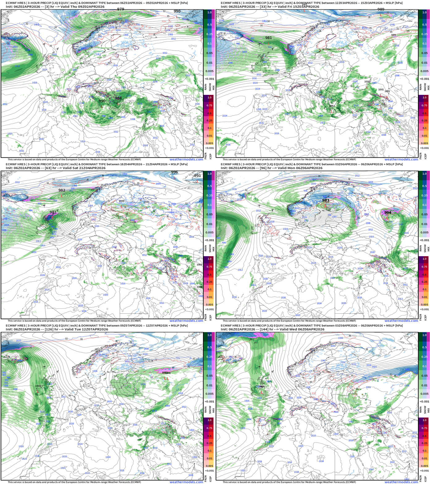
Unsettled weather across Italy and Greece — with two surface cyclones in the 990s mb tracking out of Africa northward. Snowfall next 6-days
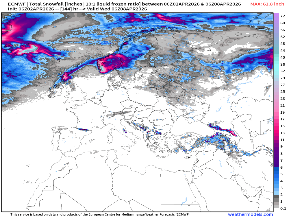
A bomb cyclone heads through the British Isles on Saturday with potential for heavy snowfall across Scotland then extending into Norway. Another 956 mb monster extratropical cyclone is upstream in the Atlantic. On Sunday, “bomb cyclone” over Atlantic well west of UK … downstream wave-breaking will fuel cut-off lows.
North America Temperature Anomaly Next 6-days
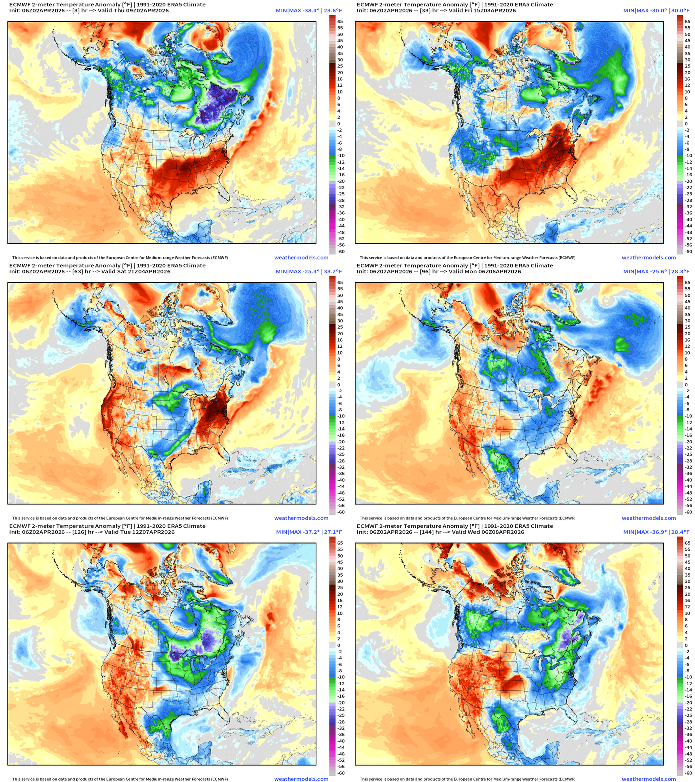
Warmth across the Eastern U.S. is wiped away by a powerful cold front attached to (2nd) storm system allowing Canadian Arctic cold pool to drop southward.
The Western U.S. warms up again this weekend after the first Pacific shortwave trough moves through.
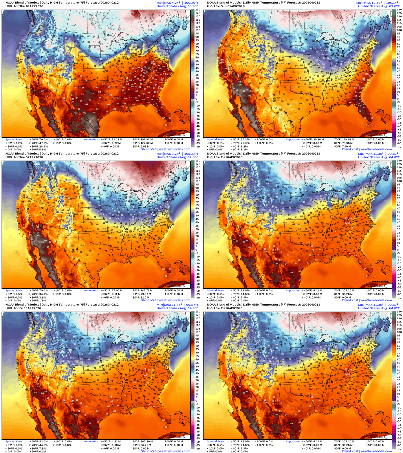
Blend of Models Temperatures | Highs through Friday, April 10
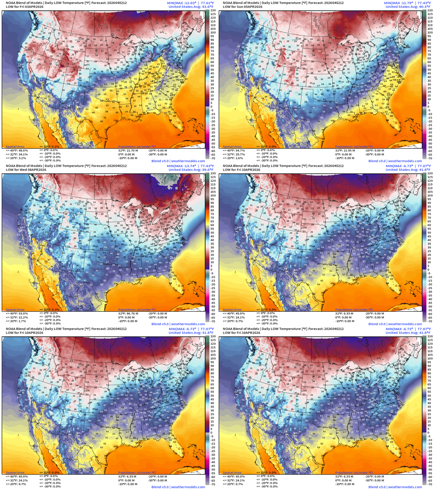
Blend of Models Temperatures | Lows through Friday, April 10
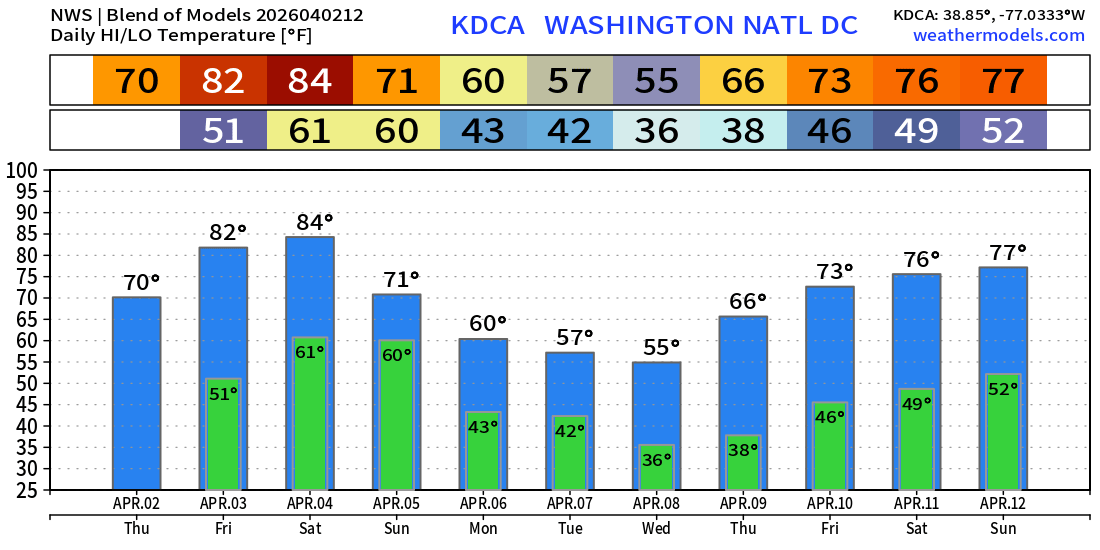
Washington D.C. next 10-days Temperatures (Blend of Models v5.0)
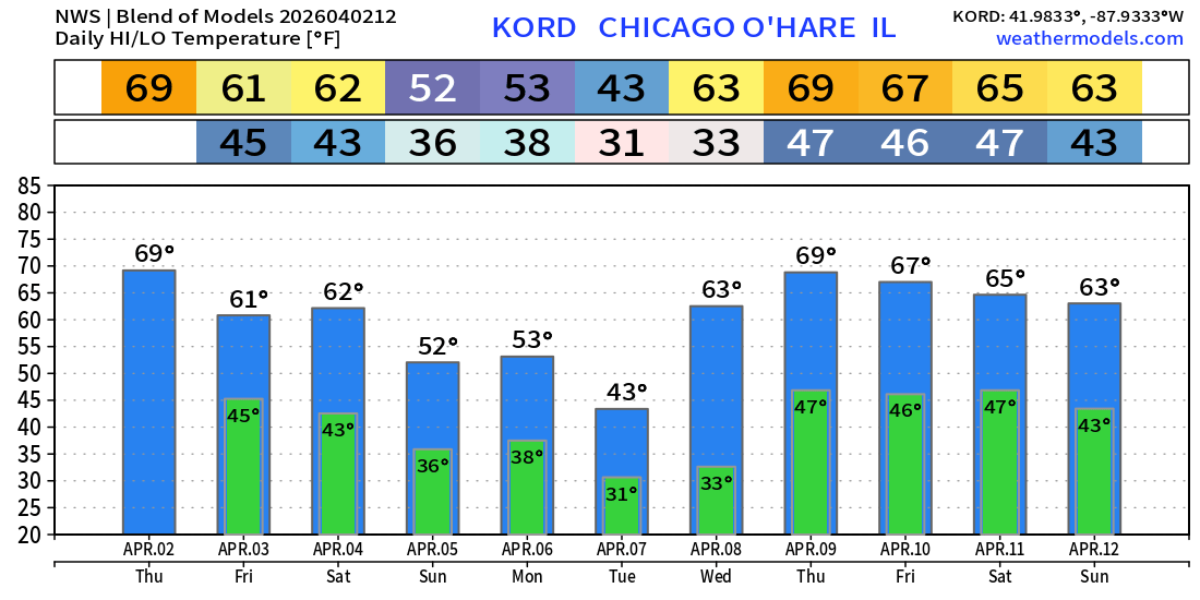
Chicago
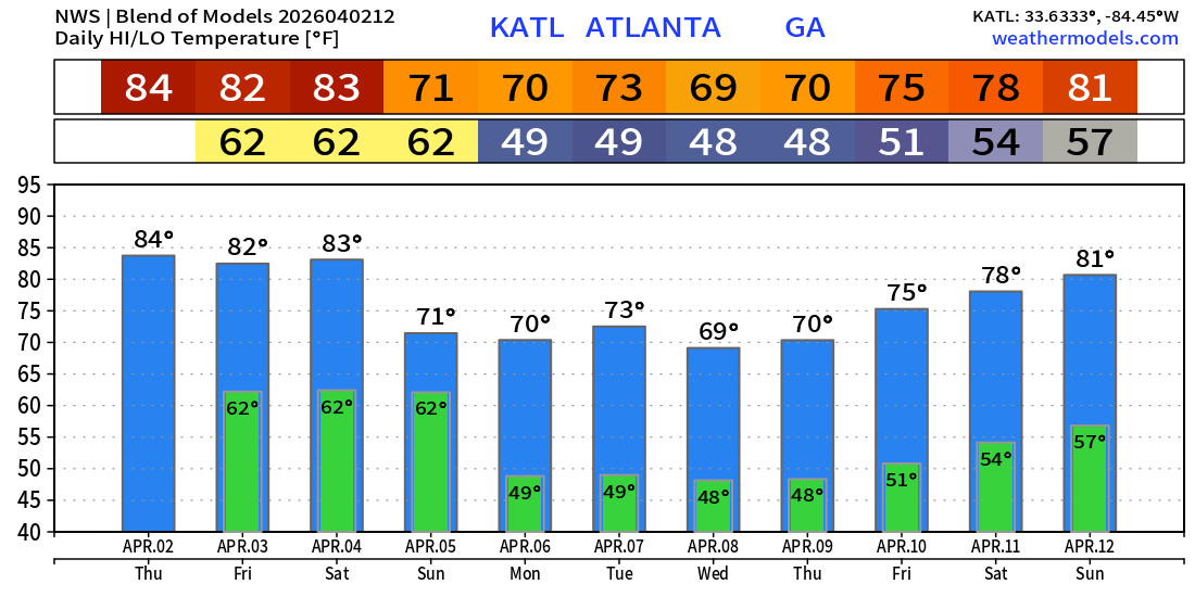
Atlanta
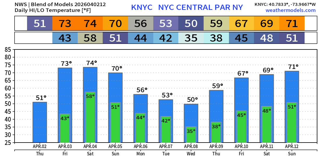
New York City
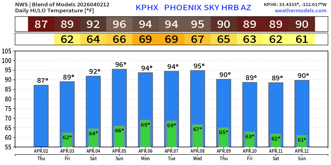
Phoenix
Blend of Models | Total Snowfall Next 8-Days
Blend of Models | 8-Days Precipitation Total
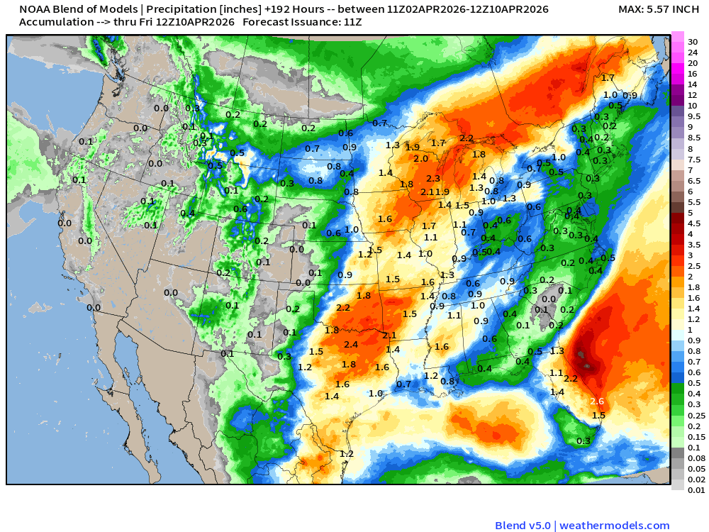
Axis of heaviest rain along the Mississippi River and into the Plains. 2” to 3” or more in thunderstorms
NDFD NWS Total Precipitation Next 72-hours through Sunday Morning
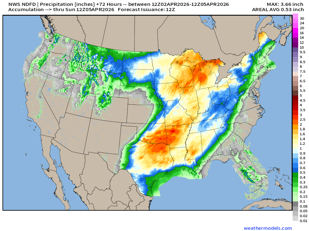
NWS Snowfall Next 72-hours — through Sunday Morning
High Temperatures Today | Thursday
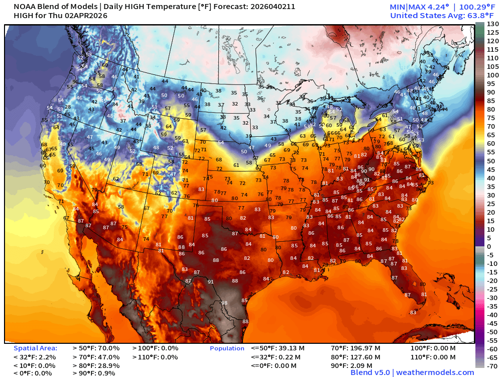
197 million at least 70°F — and 127 million at least 80°F
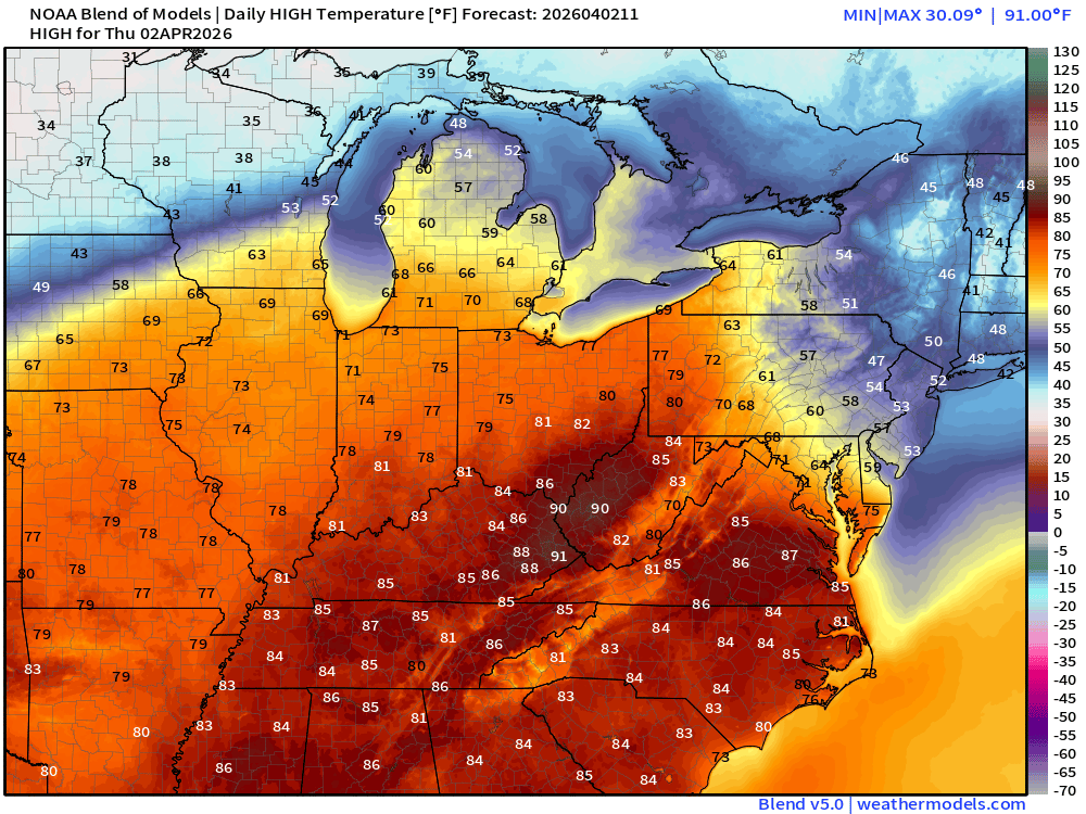
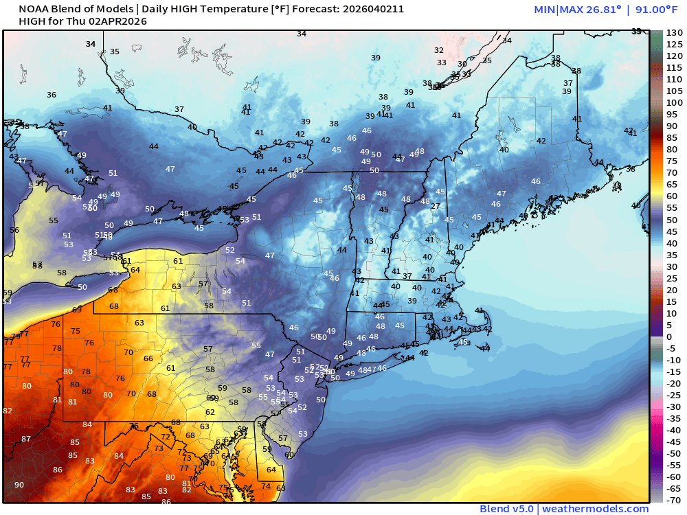
Unlucky backdoor / Northeasterly flow into New England and NYC with temperatures in the 40s and 50s.
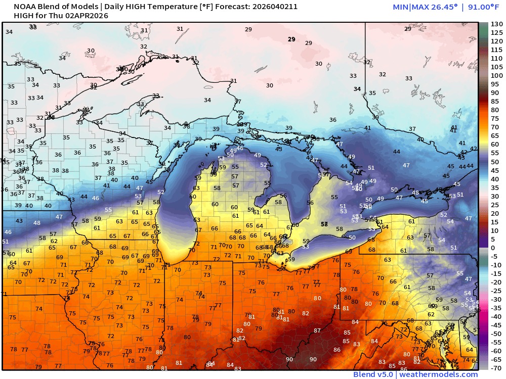
Only in the 30s across Minnesota including Minneapolis (37°F)
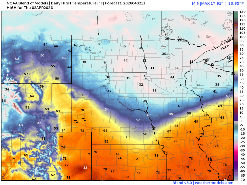
Temperature Anomaly | Highs on Thursday
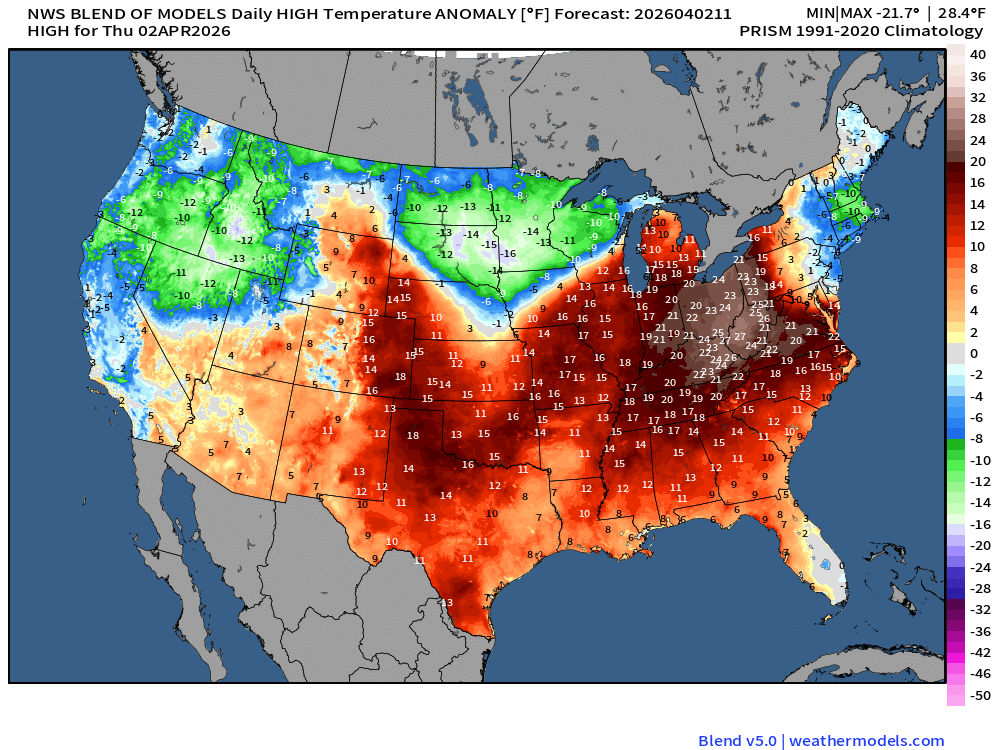
Cold across the Midwest behind the storm system … but in the warm sector, temperatures more than 25°F above normal centered on the Ohio River Valley.
Low Temperatures Friday
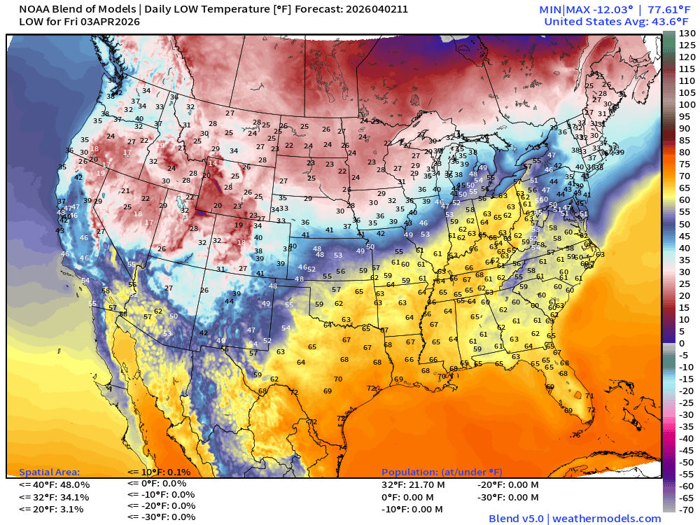
Only 22 million below freezing but 34% of real estate (across Rockies and Midwest)
High Temperatures on Friday
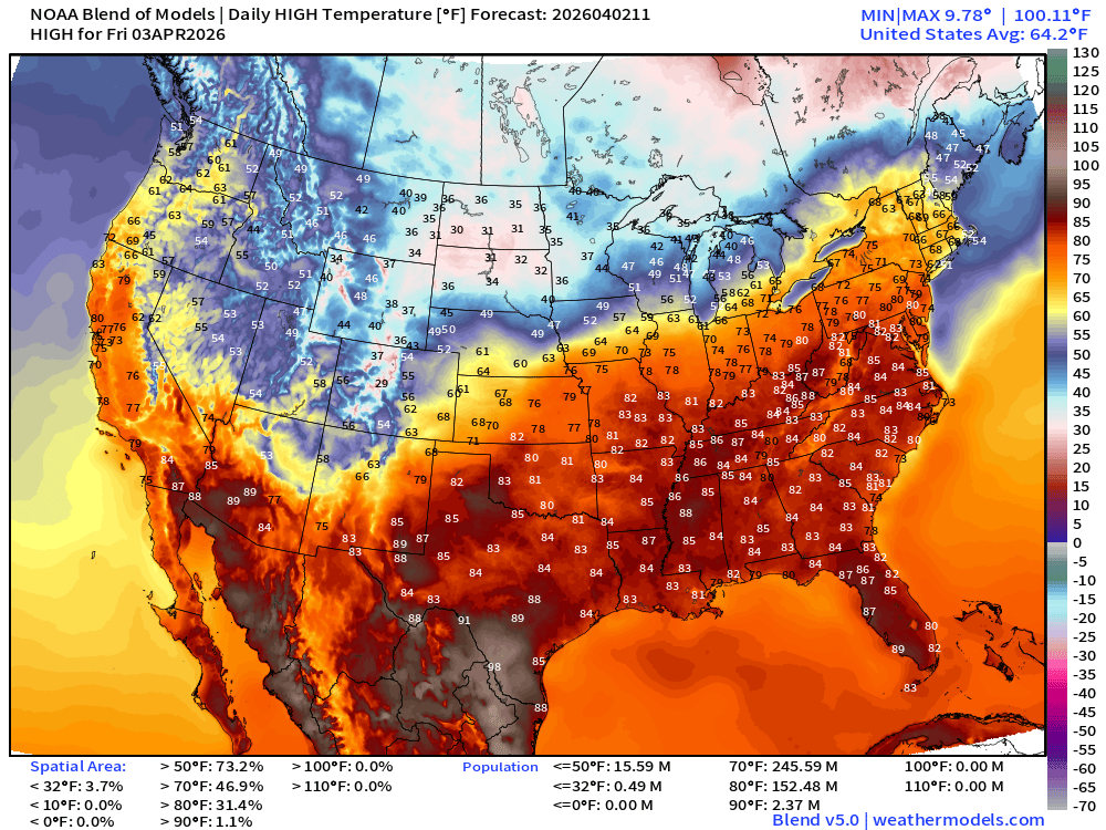
Very hot for April 3rd, well into the 80s for 152 million only 2.4 million hit 90°F
Moisture Transport | Next 12-days | ECMWF 00z
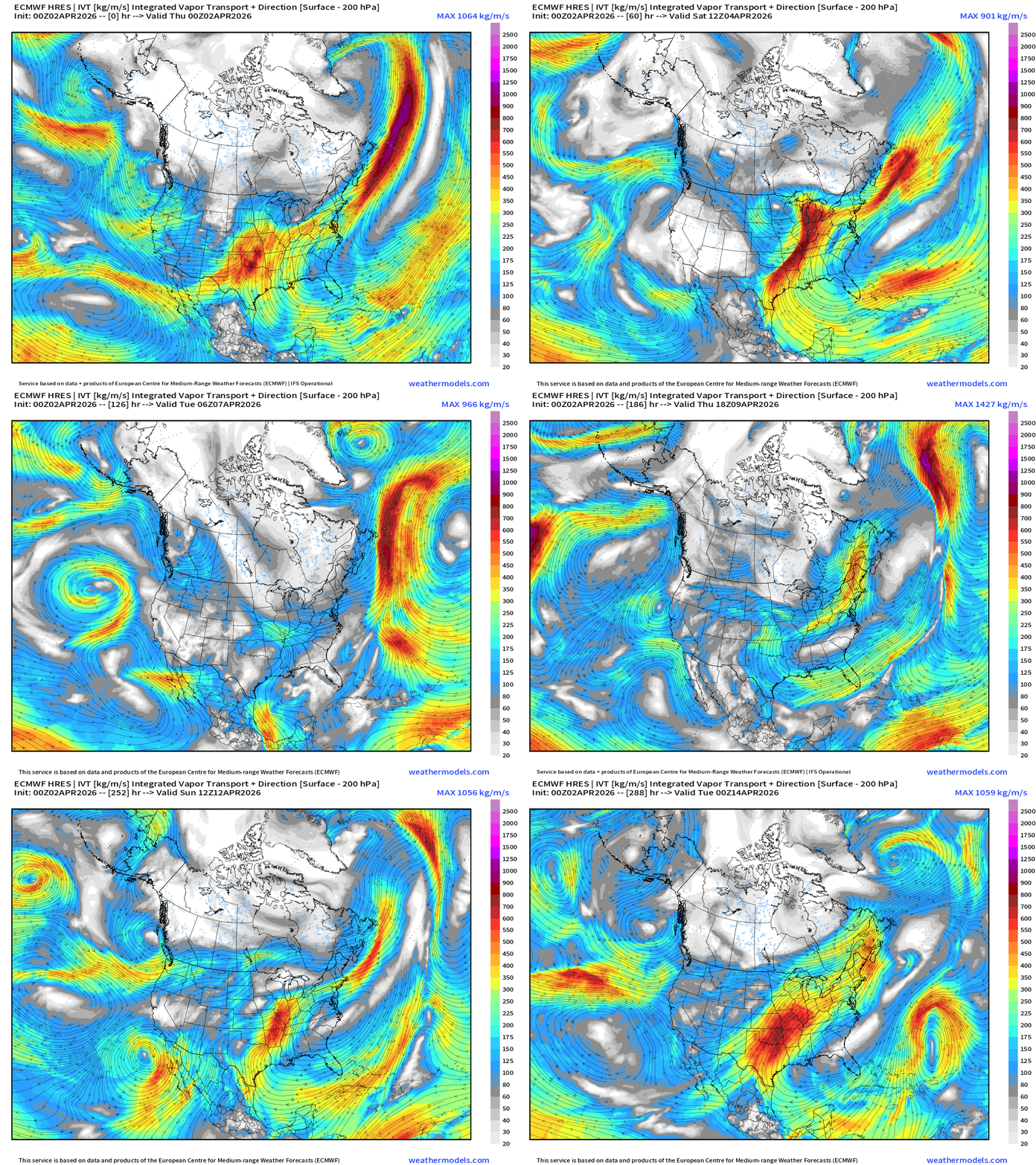
2 storm systems in the next few days with the Gulf moisture tap turned on — and then a more northerly flow out of Canada = much drier and cooler until the flow can again reverse out of the south.
ECMWF AIFS 06z | Temperature at 500 mb | Next 10-days
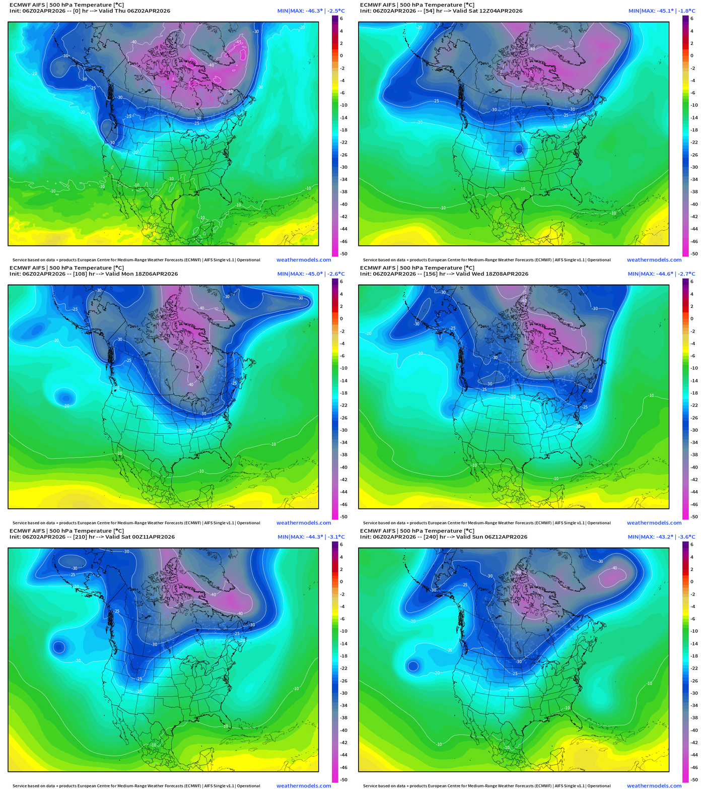
Next Wed-Thurs, the polar front dips through the Great Lakes and Northeast with a strong trough = colder but a brief spell into next weekend. Note, we are seeing the area of -40°C shrinking dramatically heading into mid-April signaling the end of Northern Hemisphere “winter” and intensity of the tropospheric polar vortex.
Snowfall from ECMWF HRES (10-days)
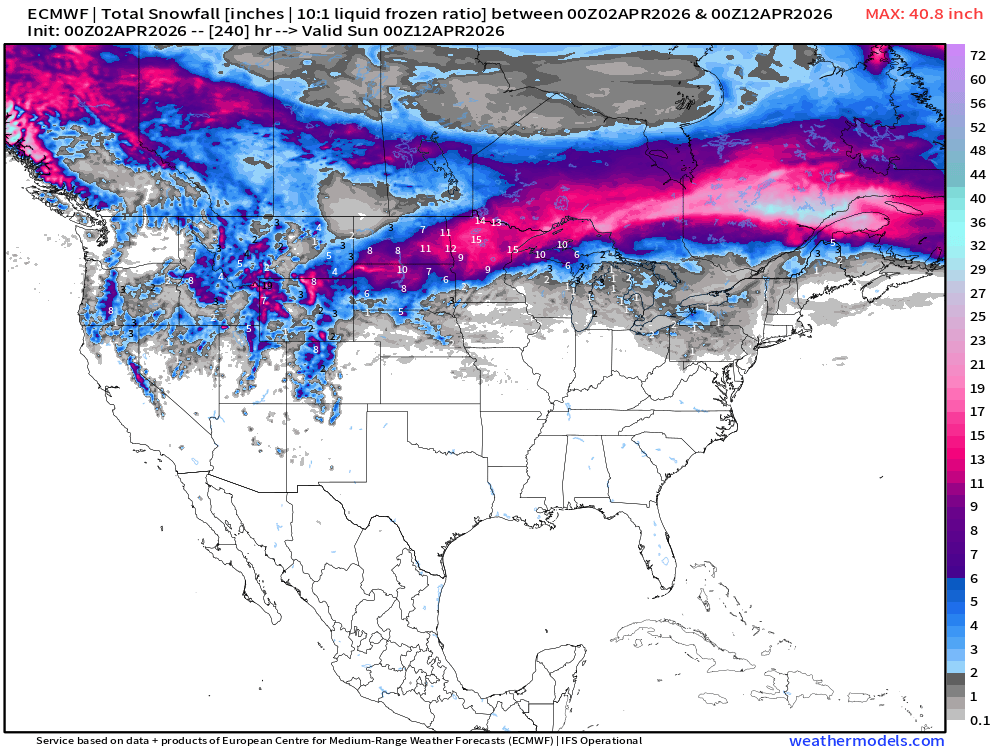
Snowfall from ECMWF AIFS-Single (06z) next 10-days
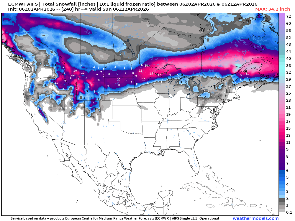
Note the close correspondence between the “data-driven” modeling from AIFS and the full resolution ECMWF HRES.
Temperature Anomaly | Next 15-days | ECMWF EPS 00z Ensemble Mean
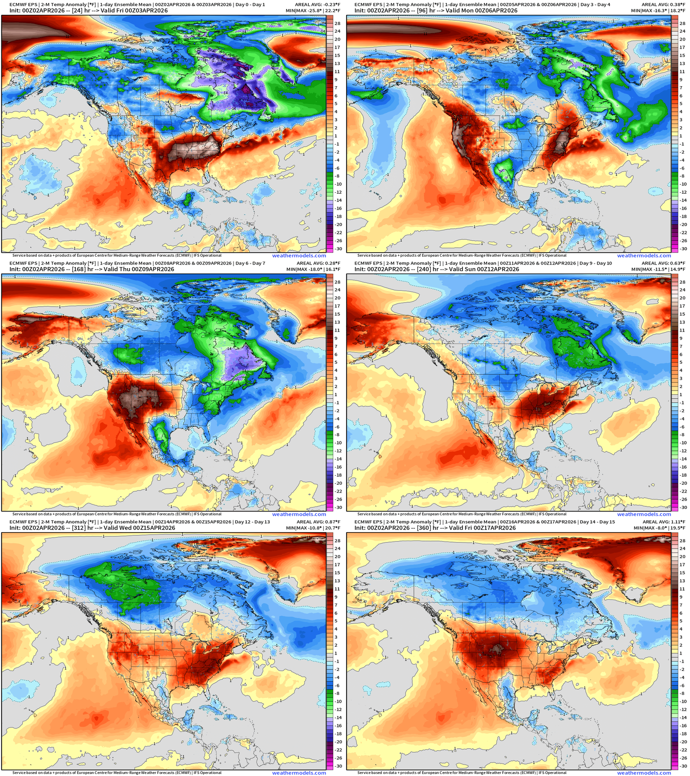
A strong Canadian Arctic cold front will blast into the Great Lakes and Northeast late next week. Then a significant warmup to more mild Spring time weather
Europe temperature anomaly next 10-days
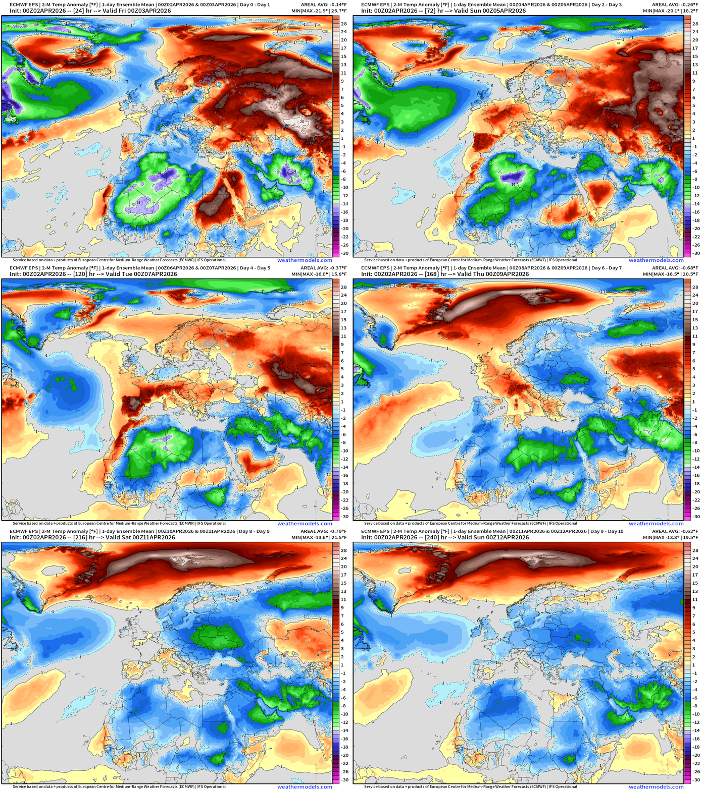
Configuration of blocks and cut-off troughs continues to funnel Arctic and midlatitude cooler air into North Africa and the Middle East.
Week #1 | Temperature Anomaly | April 2 - April 8
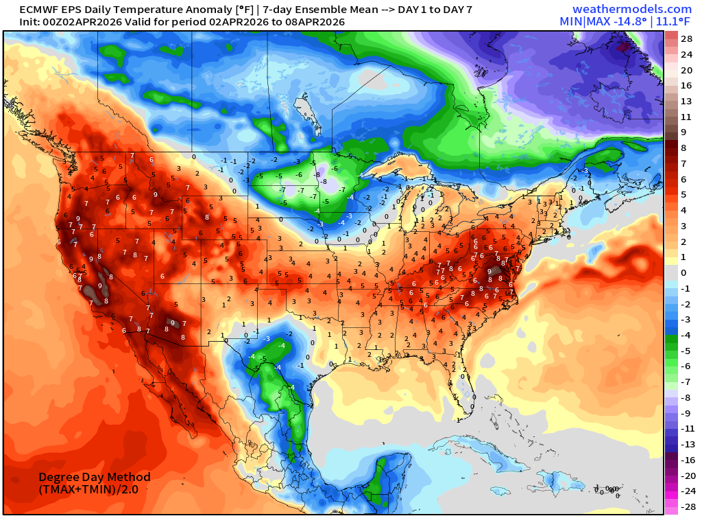
Colder than normal air when averaged across the entire week wins out in the Midwest
Week #2 | Temperature Anomaly | April 9 - April 15
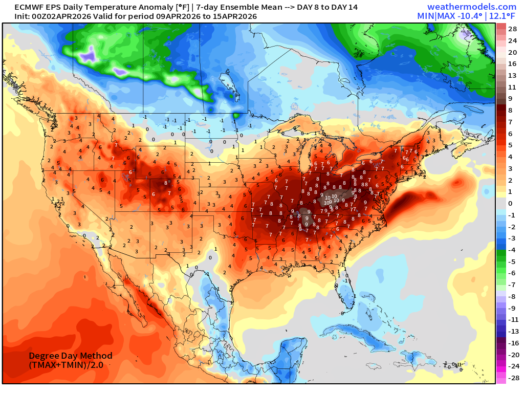
Much of the Lower 48 is above normal for Week 2 (into mid-April)
Maps sourced from weathermodels.com designed and innovated by yours truly! Please subscribe there for real-time access to the newest maps, charts from all of the weather models including ECMWF and AIFS, and NOAA GFS/GEFS. NOAA WPC and SPC for fronts/convective outlooks.
- Milepost
- 910 · laid 2026-04-02T14:44:19.683000Z
- Source
- https://weather.substack.com/p/april-2-2026-thursday-spring-weather
- Digest
- 23a71a6ae1b8430c5009f2ddfa2aace882b20abb975a5a276637d73bc91de0be
- Machine
- JSON