September 4, 2023 Hurricane Season
Watching Invest 95L for Tropical Depression by Wednesday
September 2023 was the 9th-warmest September in the 131-year national record (1895–2025), at 67.7°F against a 1991–2020 normal of 66.0°F (+1.8°F).
September 2023 was the 27th-driest September in the 131-year national record (1895–2025), at 2.1in against a 1991–2020 normal of 2.6in (-0.4in).
NOAA/NCEI Climate at a Glance, contiguous United States. This is the observed record for the month, not a score of anything said in this piece — the forecast ledger begins 2026-08-17 and cannot reach earlier posts.
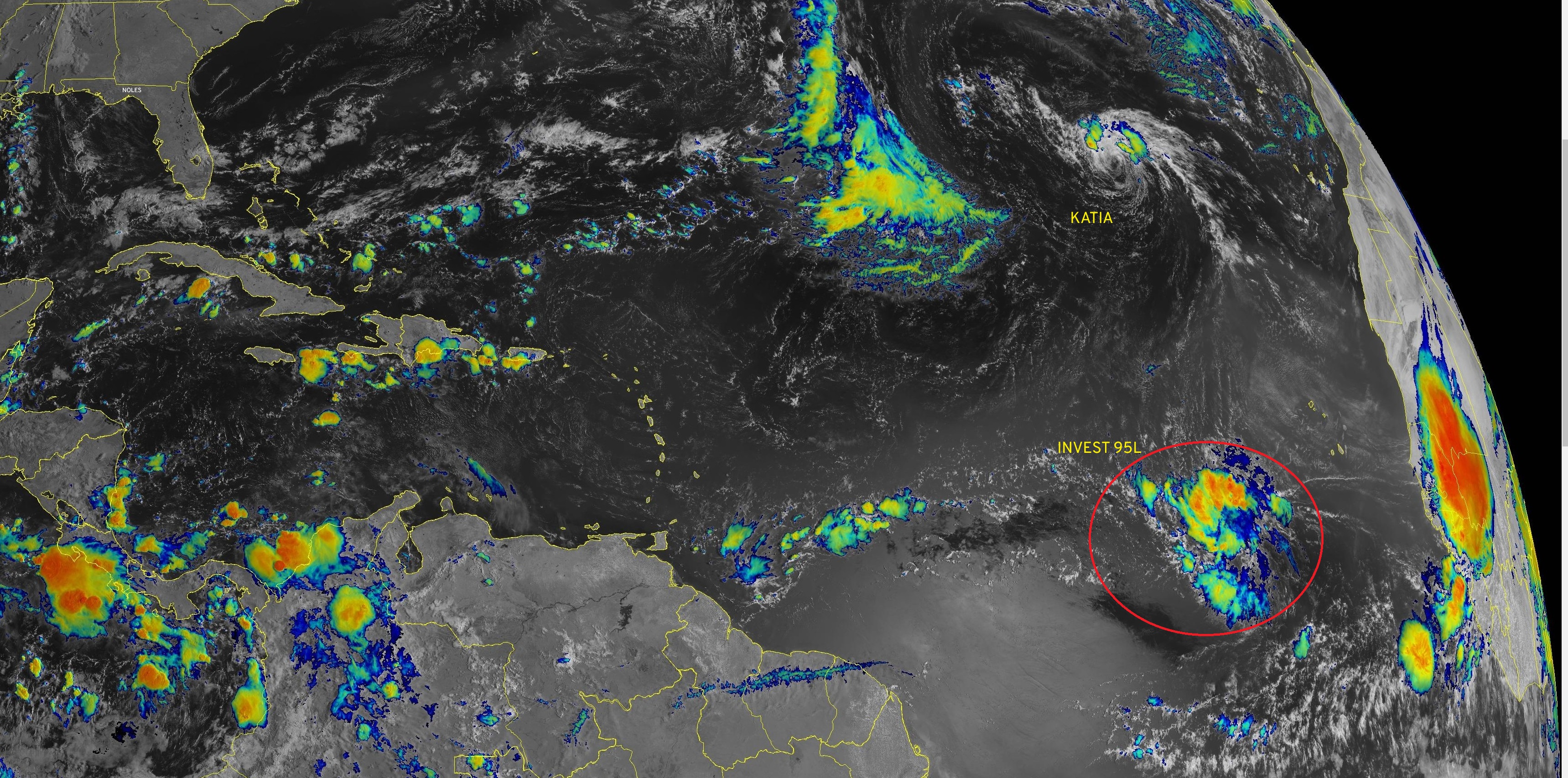
Invest 95L is expected to develop [70% next 2-days] into a tropical depression by Wednesday and then intensify into a major hurricane by end of coming week, possibly a Category 5. The next name is Lee. The powerful hurricane is most likely to track well north of the Leeward Islands and Puerto Rico.
2023 Medium Range Atlantic Tropics
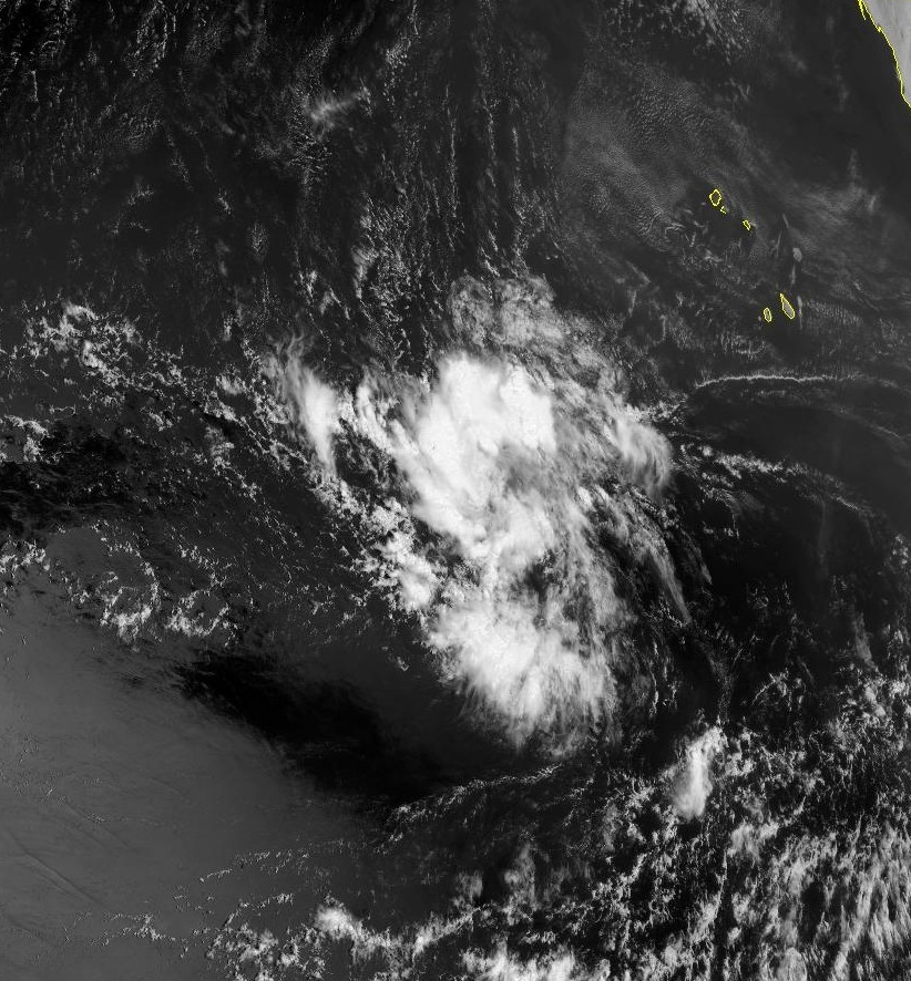
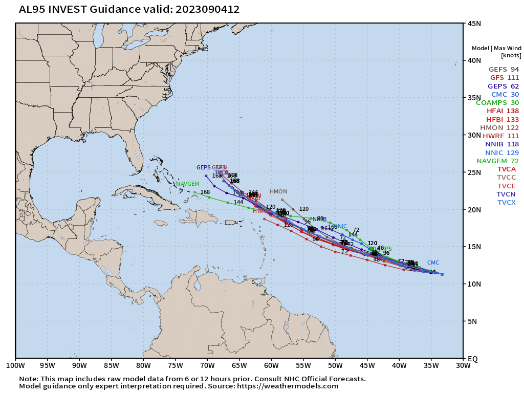
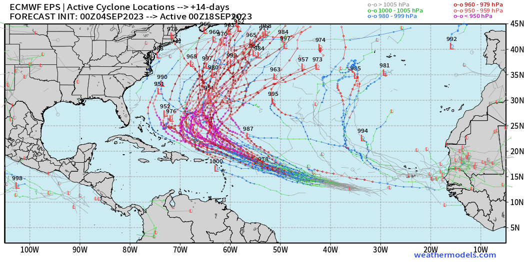
Invest 95L is slowly organizing, and should reach Tropical Depression status sometime on Tuesday. Global and mesoscale model tracks are tightly clustered through the next 7-days on a WNW course to east of the Bahamas by early next week.
HAFS-A and HAFS-B intensity forecasts are now in the 920s and 930s with maximum sustained winds consistent with Category 4+ hurricane. I usually post 850-hPa winds and do a quick 10% reduction to get the near-surface intensity since 10-meter winds are often undercooked in weather models.
ECMWF 00z takes Invest 95L (Hurricane Lee) on an abrupt right turn as a strong trough digs off the East Coast of the U.S.
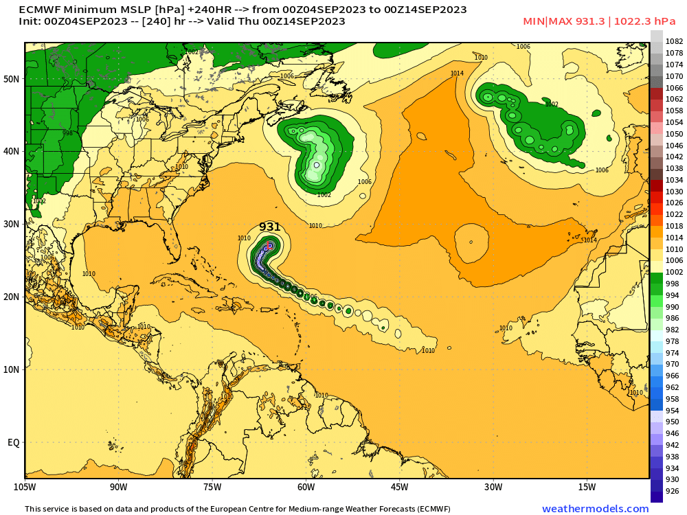
All tracks are abruptly turned out to sea, except for 1 that randomly targets New England. That leaves 98% missing the East Coast of the U.S.
Atlantic 2023 Year to Date | ACE: 58 (149% normal | 39)
Unnamed Subtropical Storm [January 2023]
Arlene 02L: 35 knots, Bret 03L: 60 knots, Cindy 04L: 50 knots
Don 05L: 65 knots, Emily 07L: 45 knots, Franklin 08L: 130 knots
Gert 06L: 40+ knots, Harold 09L: 45-knots, Idalia: 115-knots
Jose: 50-knots, Katia: tropical storm, Lee and Margot are next
2023 Eastern Pacific Hurricane Season
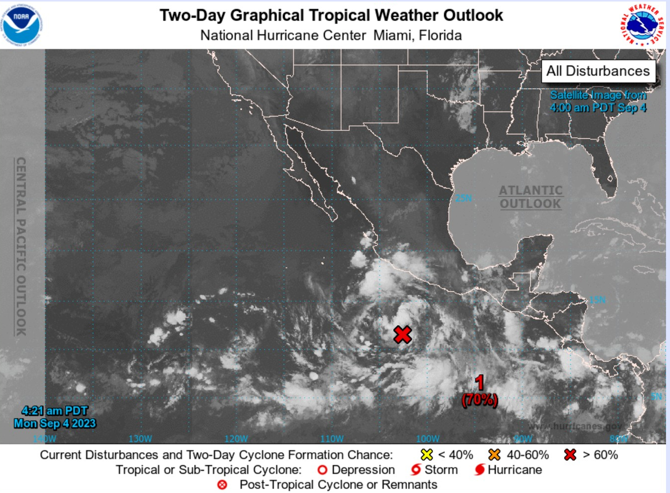
Invest 93E is expected to develop soon. Still a very high chance, however no impacts to land.
Formation chance through 7 days...high...90 percent.
Eastern Pacific 2023 | Year to Date ACE 106 (127% of normal | 83)
Adrian 01E: 90 knots, Beatriz 02E: 75 knots, Calvin 03E: 110 knots
Four 04E: 30 knots, Dora 05E: 125 knots, Eugene 06E: 60 knots
Fernanda 07E: 115 knots, Greg 08E: 45 knots
Hilary 09E: 125 knots, Irwin 10E: 40 knots
2023 Western Pacific Typhoon Season
The Western Pacific is taking a break after TS Haikui (10W) makes landfall in China at 45-50 knots.
Western Pacific Typhoon 2023 YTD ACE: 212 (152% normal | 139)
Sanvu 01W: 30 knots, Mawar 02W: 160 knots, Guchol 03W: 90 knots
Talim 04W: 85 knots, Doksuri 05W: 130 knots, Khanun 06W: 120 knots
Lan 07W: 115 knots, Damrey 08W: 65 knots, Saola 09W: 135 knots
Haikui 10W: typhoon, Kirogi 11W: tropical storm
- Milepost
- 89 · laid 2023-09-04T13:32:58.482000Z
- Source
- https://weather.substack.com/p/september-4-2023-hurricane-season
- Digest
- 35612666029d147ff223837e1f6074b52f0110f2a18e6797d1e0f7d0d354cf54
- Machine
- JSON