January 27, 2026 Tuesday Frigid Winter Weather
Blockbuster blizzard on tap for this weekend with extremely cold air into Florida
January 2026 was the 25th-warmest January in the 132-year national record (1895–2026), at 33.1°F against a 1991–2020 normal of 32.3°F (+0.8°F).
January 2026 was the 12th-driest January in the 132-year national record (1895–2026), at 1.6in against a 1991–2020 normal of 2.3in (-0.8in).
NOAA/NCEI Climate at a Glance, contiguous United States. This is the observed record for the month, not a score of anything said in this piece — the forecast ledger begins 2026-08-17 and cannot reach earlier posts.

Heat Dome Down Under! Temperatures pushing 120°F western New South Wales and Queensland on Wednesday. This is top / hot news in Australia, but it’s summer, so “seasonable” heat.
If you are a first time visitor but not signed up to receive my daily update emails — please do!
Headlines
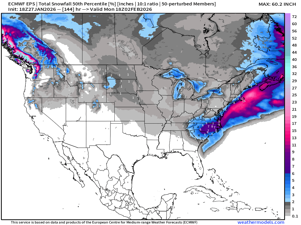
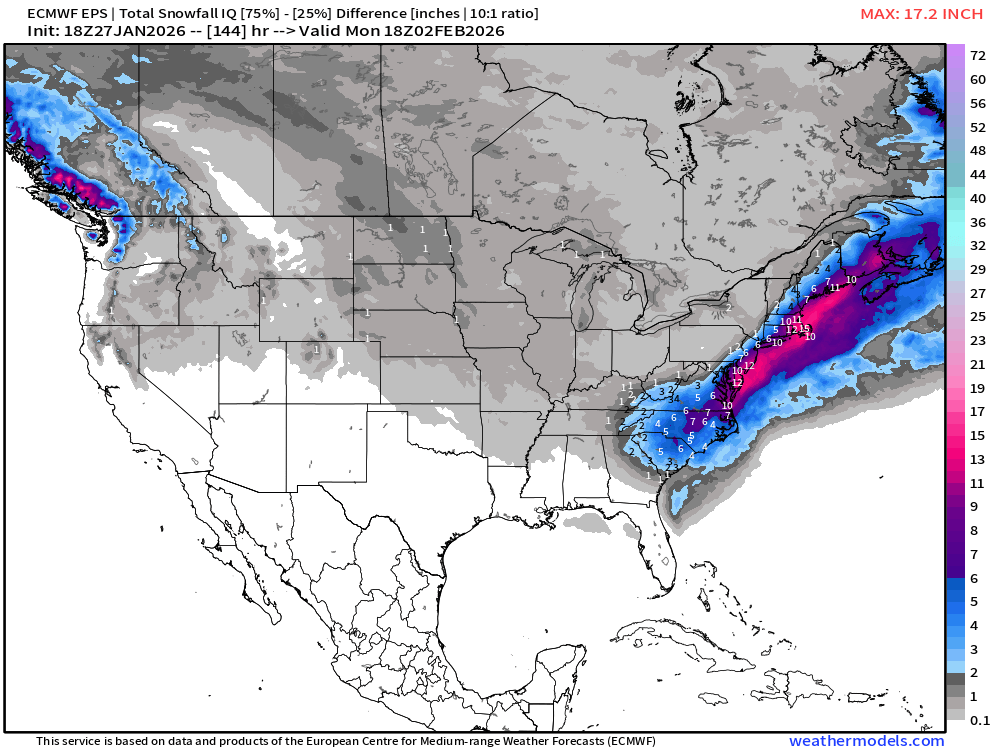
Development of a massive coastal storm —> major impacts for Mid-Atlantic and Northeast. The recent model guidance for 18z from ECMWF (EPS and AIFS) has edged westward more in line with the GFS model trends — which is a bit ahead of the pack — with major snowfall to North Carolina and Virginia, then up the coast clipping Delaware, Long Island, and Cape Cod Boston.
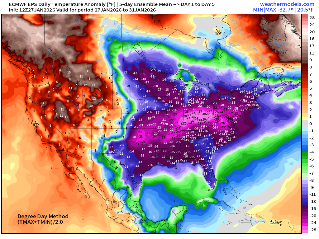
Frigid cold air remain in place across the Eastern 1/3 of the Lower 48 with a freeze threat to South Florida this Sunday and Monday. We may need to wait until February 6th time frame for a sustained thaw across the Great Lakes and Mid-Atlantic and Northeast.
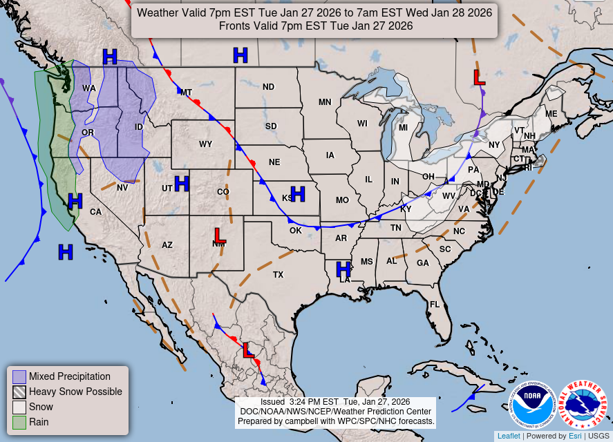
Current Weather: Quiet across much of the Lower 48. Lake Effect Snowfall continues to pile up especially downwind of Ontario in New York. Moisture returns to the West Coast — woohoo!
RTMA | Temperature Analysis | Last 24-hours
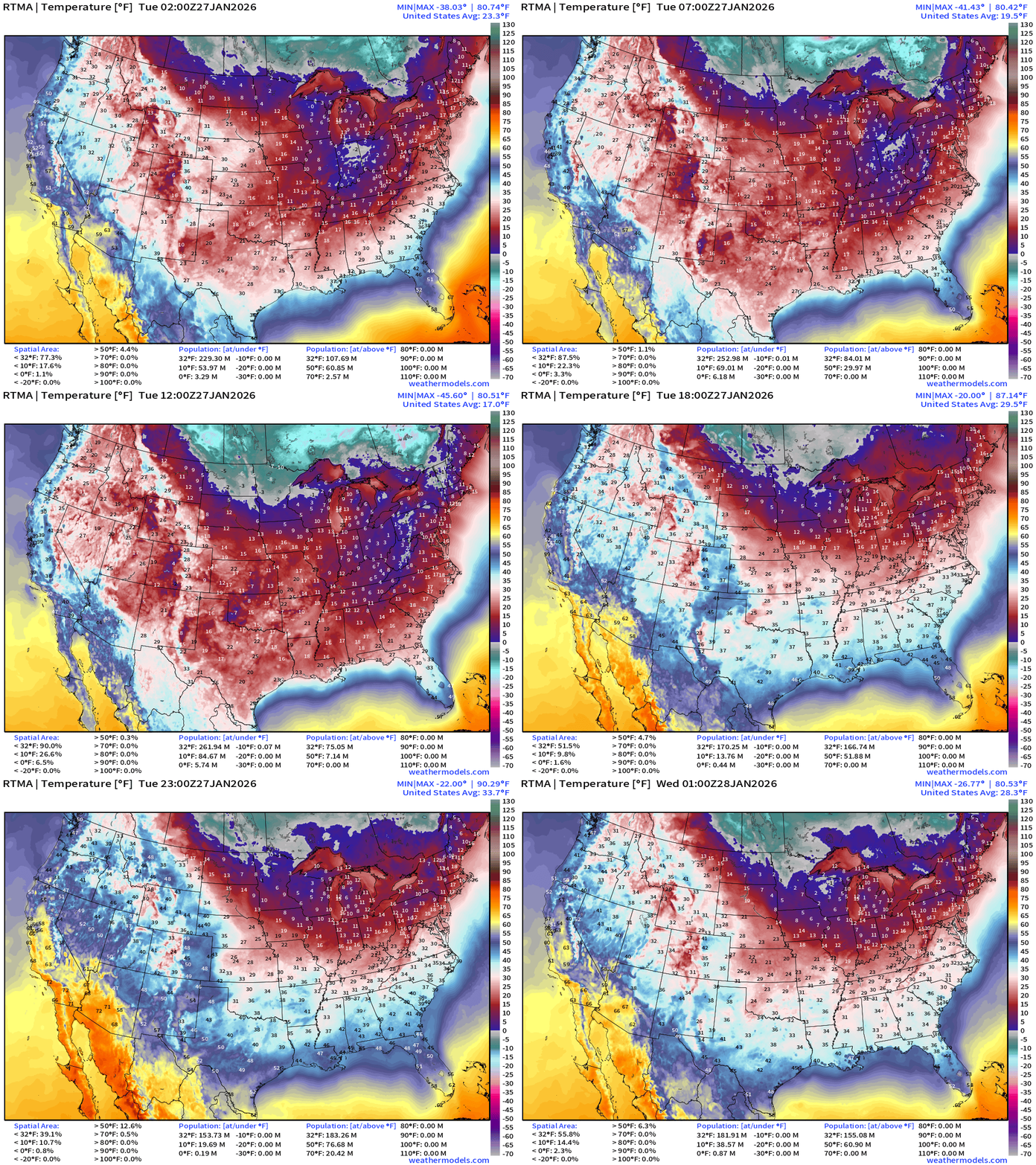
8 PM ET: Average Lower 48 temperature was 28.3°F —182 million below freezing.
Temperature Anomaly | Last 24-hours
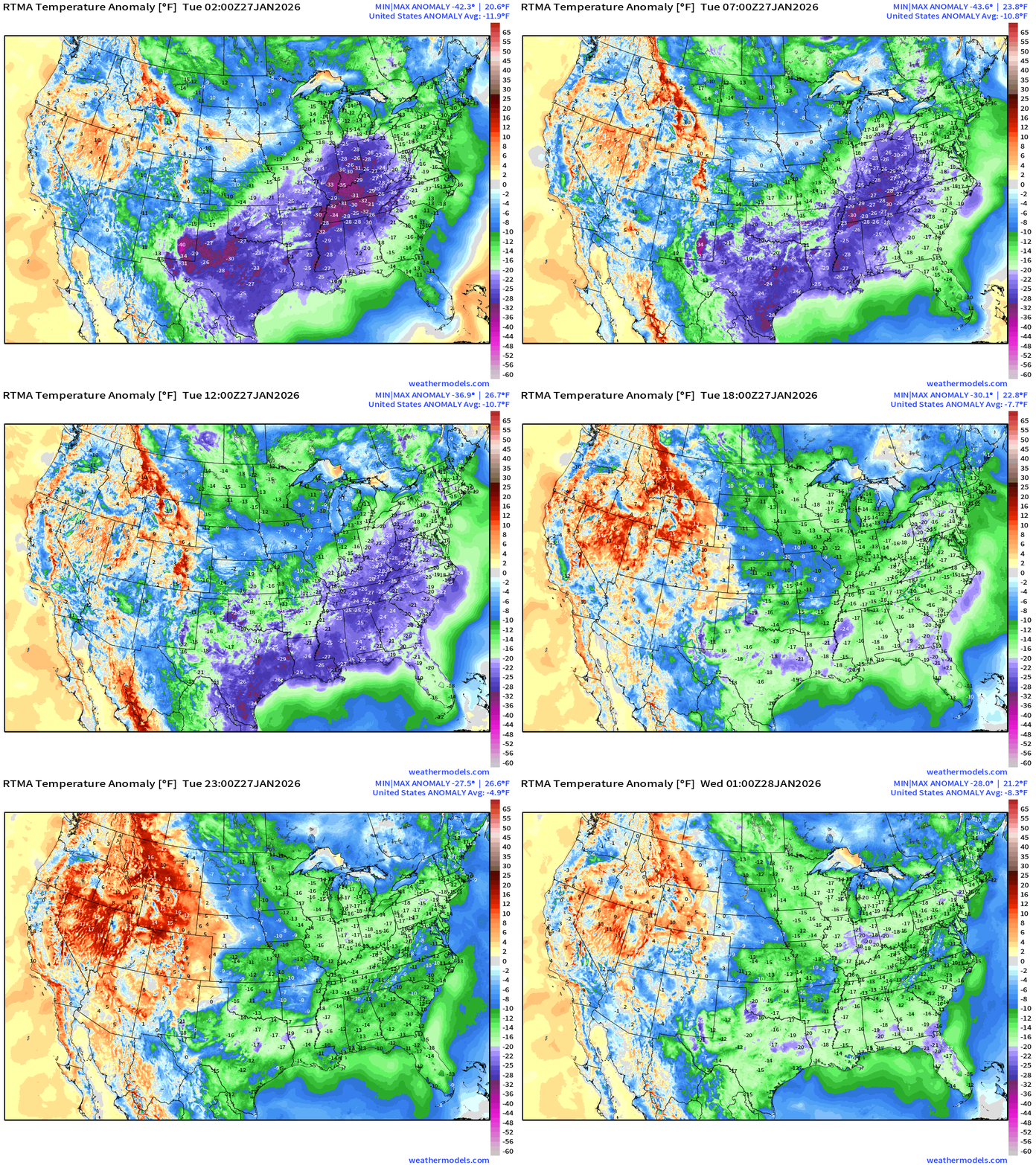
8 PM ET: Lower 48 Temperature Anomaly below normal by -8.3°F
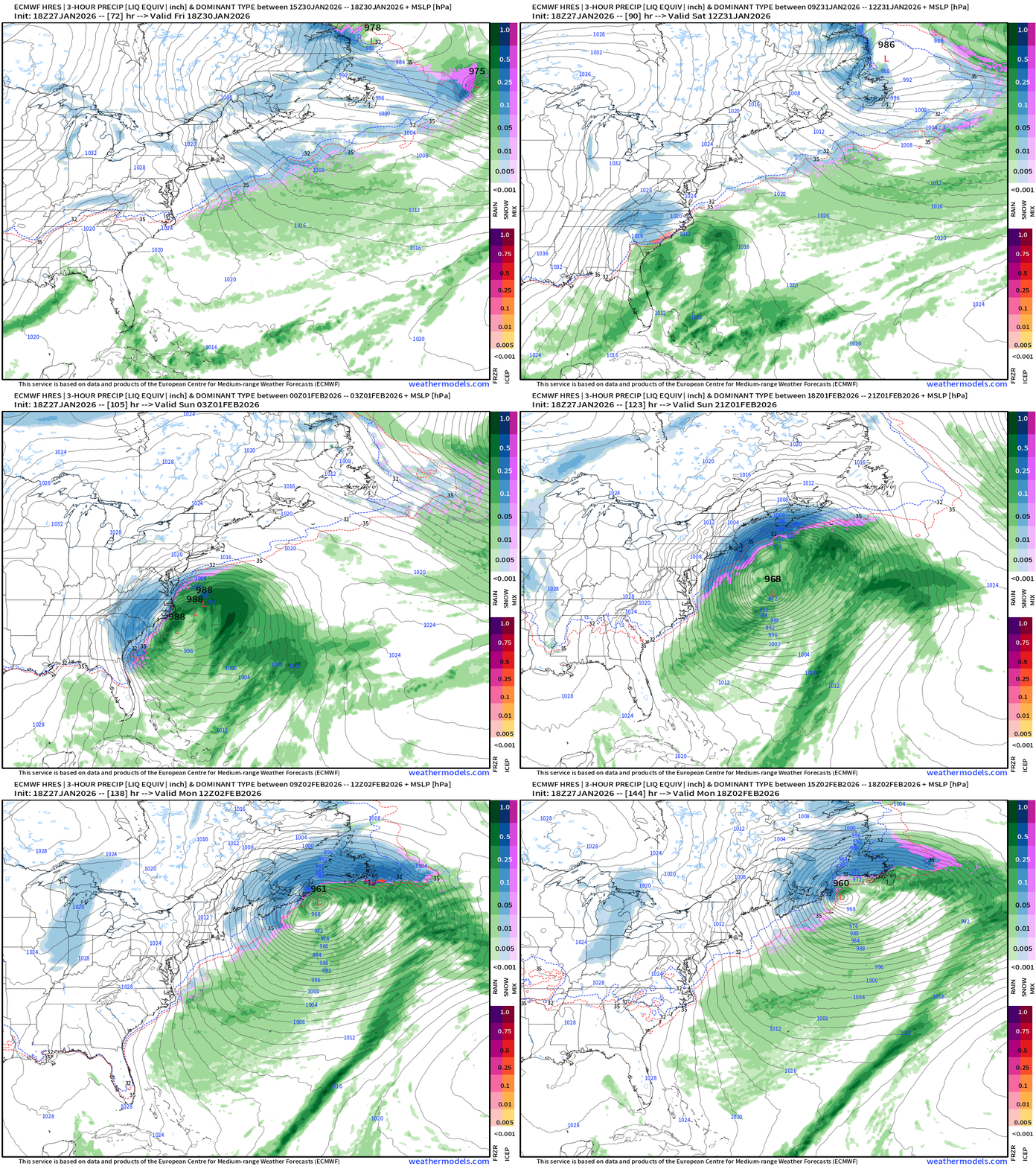
Precipitation Type and Intensity Next 6-days (ECMWF 18z)
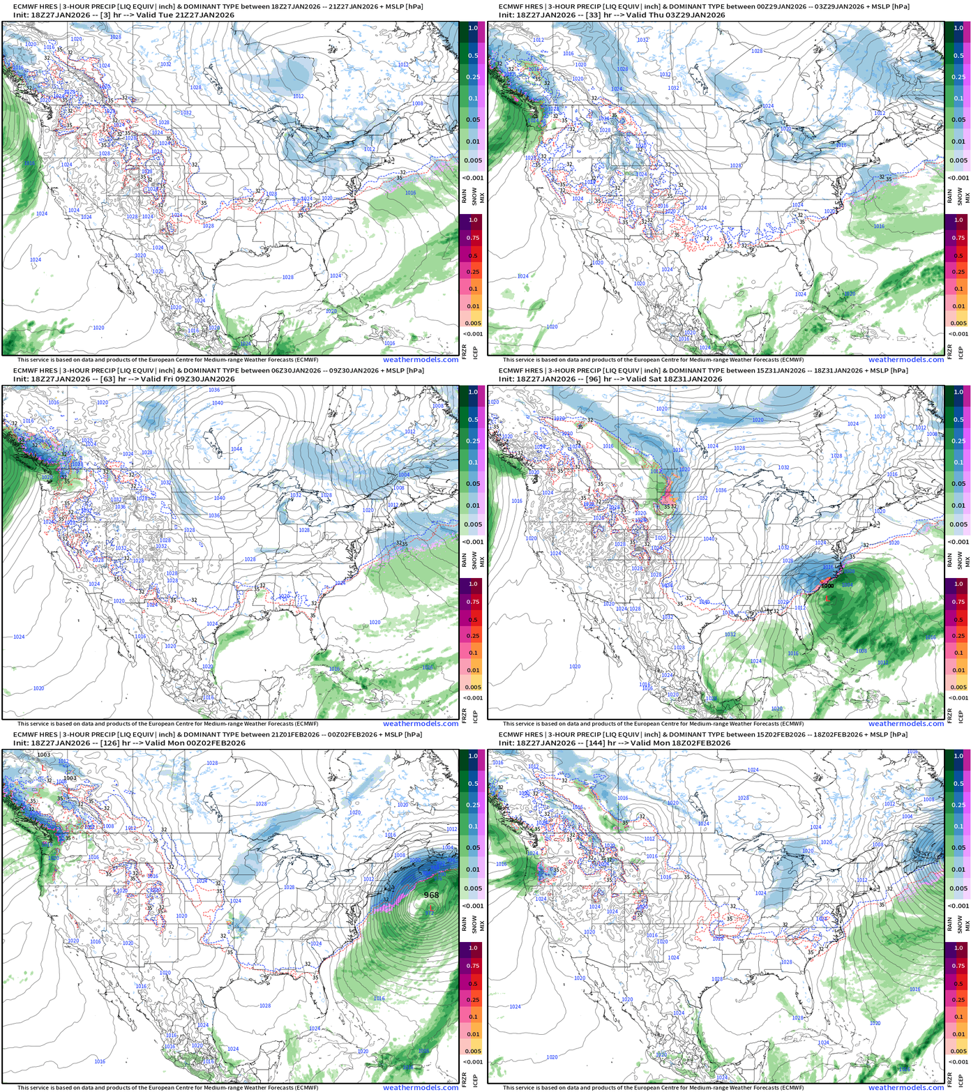
Some rainfall and mountain snow finally returning to the Pacific Northwest.
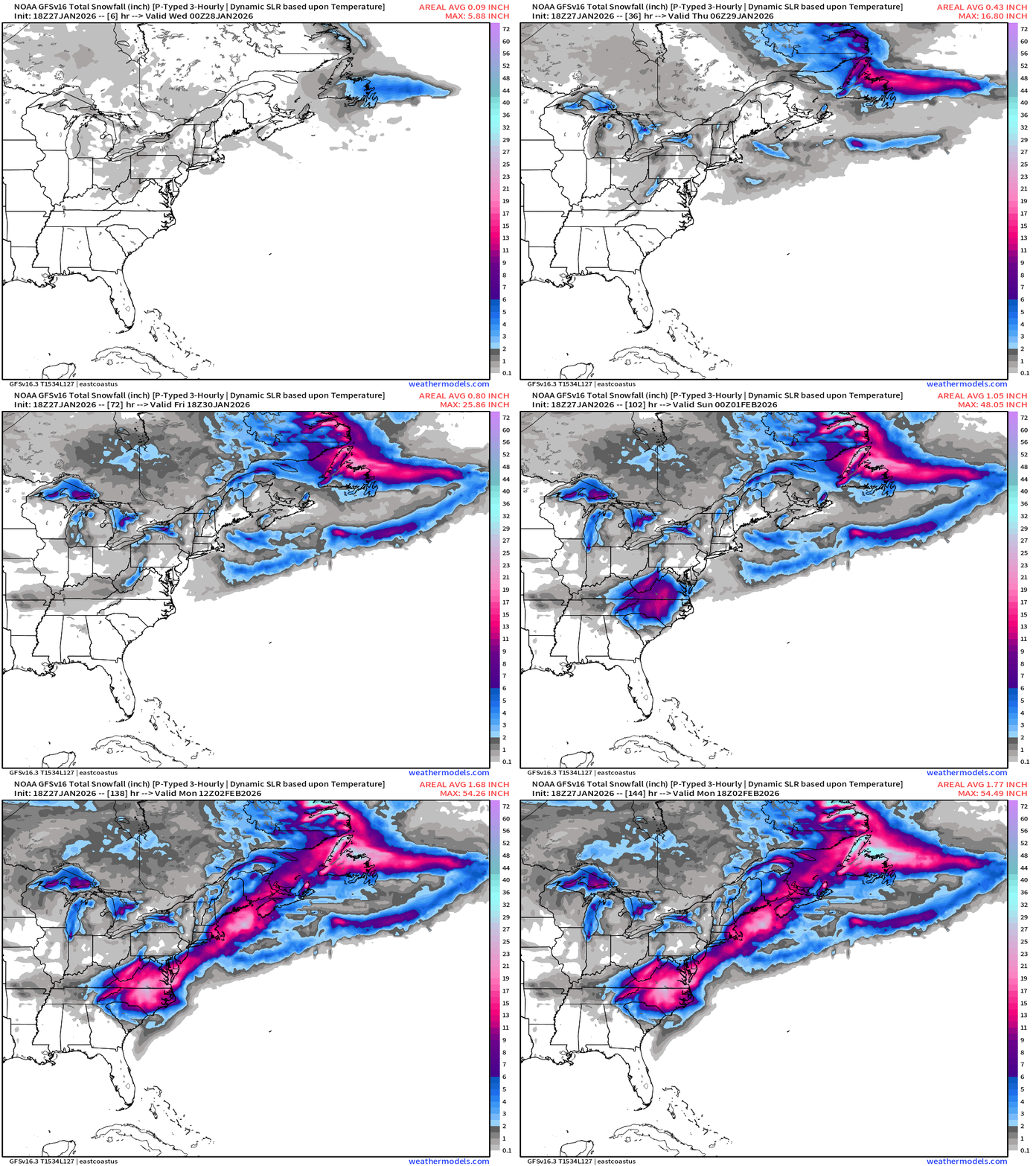
Otherwise, the rest of the U.S. to the East Coast will be under the firm grip of Arctic high pressure. The storm system develops on the periphery of a “polar vortex” lobe trough moving through the Southeast. The surface low phases with the jet stream over the warm Gulf Stream and “bombs out”. The storm shifted westward with the 18z cycle, along with the ensembles, increasing confidence in heavy snowfall at least for NC/VA but also maybe northward — but too soon to bury D.C. in another foot of snowfall. However, Boston looks rather likely to get backside snowfall from this “blockbuster blizzard”
From IFS or the HRES 18z component of the ECMWF ensembles: QPF as snowfall includes snowfall off the Florida coastline including Jax down to Daytona.
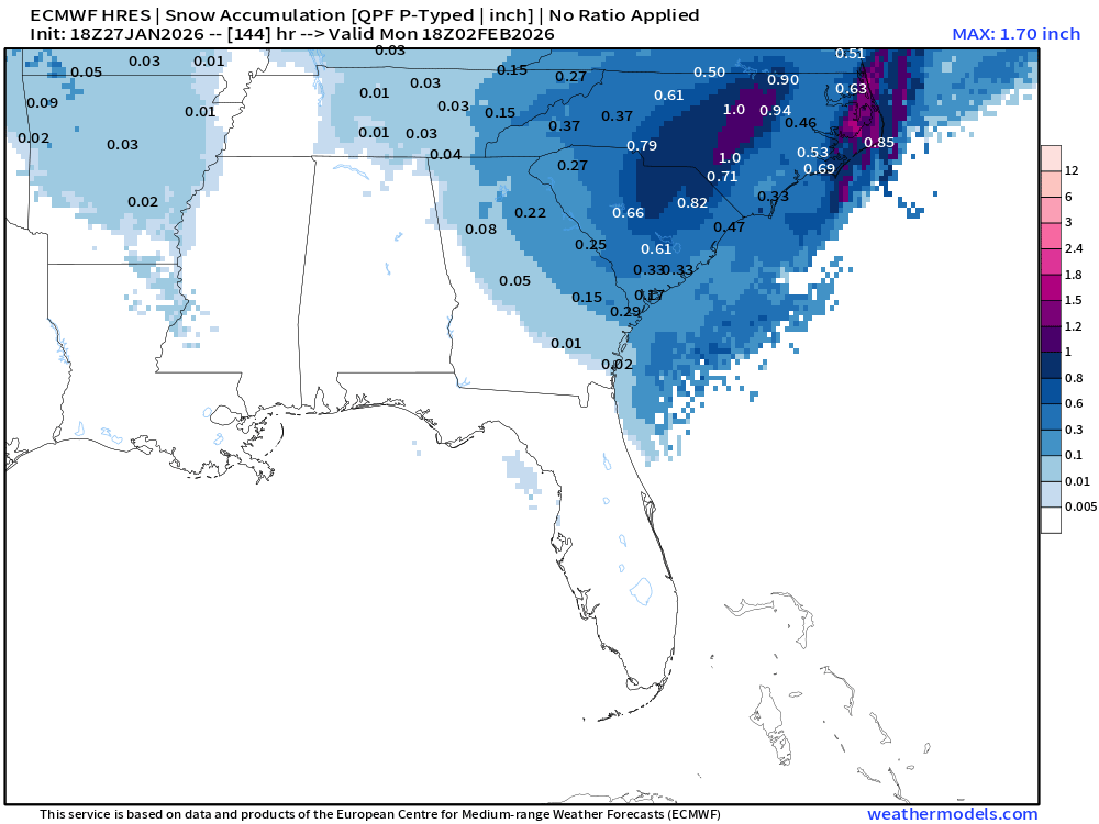
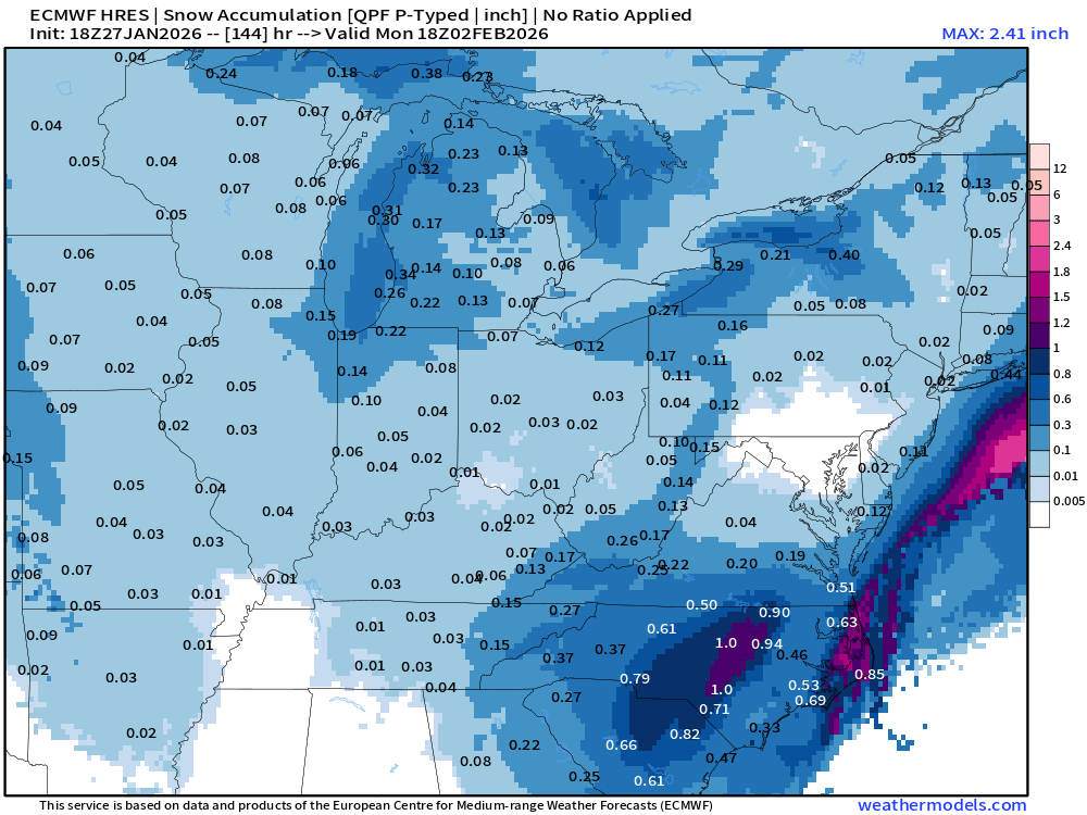
Heavy Snow Amounts in NC and VA and along the Outer Banks but the “DC snow hole” remains intact with this 18z iteration
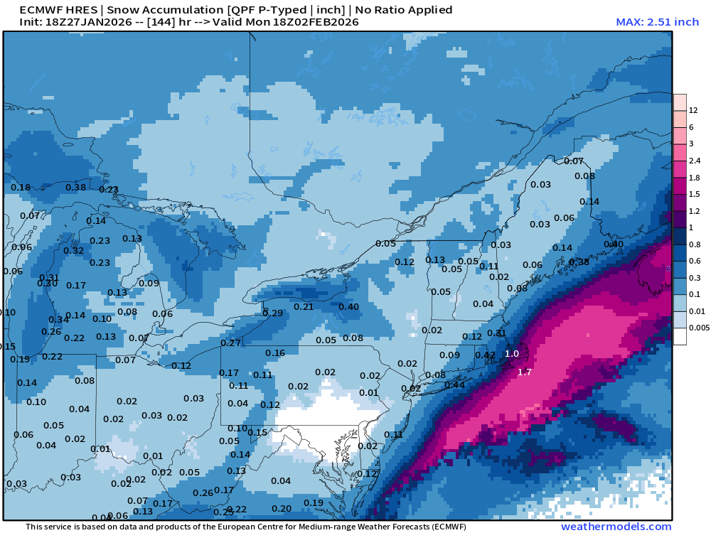
1.0” of snowfall as QPF in Boston would likely to be another 18” of snowfall as measured by a yard stick — which you may need a longer one.
ECMWF 18z EPS Median Snowfall — edging westward ever so slightly!
ECMWF 18z EPS Snowfall | 75th minus 25th Percentile to show “spread” or range of outcomes on the table.
NOAA GFS 18z
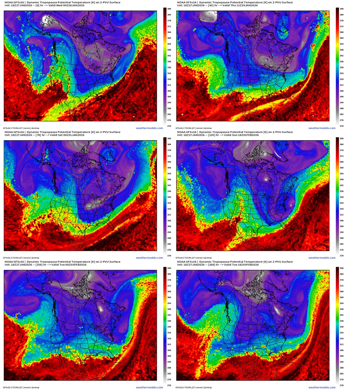
A look at NOAA GFS 18z — which may have had the best handle on this system considering it started out with the most “westward” track. So, I will certainly give it credit. The dynamic tropopause shows the disturbance aloft that will trigger the rapid cyclogenesis off the coast. It originates from Hudson Bay and whips like a pendulum through the southeast.
A more westward track by 50-100 miles has been indicated by GFS for the last 2-days, and continues into 18z this evening.
Forecast Snowfall From GFS 18z is “boom” over North Carolina and Virginia — not worrying about freezing rain or sleet anymore, this is heavy snowfall into cold, Arctic air.
NWS NDFD Snowfall next 3-days | Lake Effect until they freeze over
ECMWF AIFS Sunday +5 days | Monster Blizzard at 976 mb
AIFS Snowfall Next 7-days
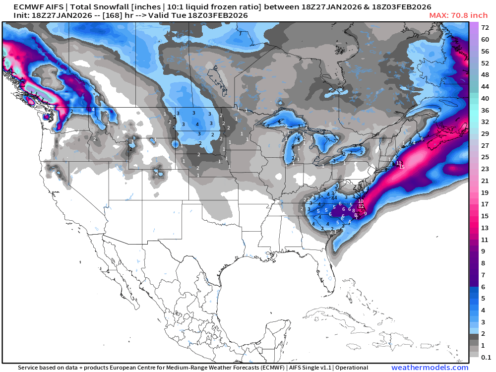
Snow to liquid ratios would be well in excess of 10:1 to these totals would be underestimates.
Another Blizzard at Day 10 to Monitor — these usually come in 2’s
Continuing Brutal Cold
ECMWF Temperature Anomaly Next 6-days
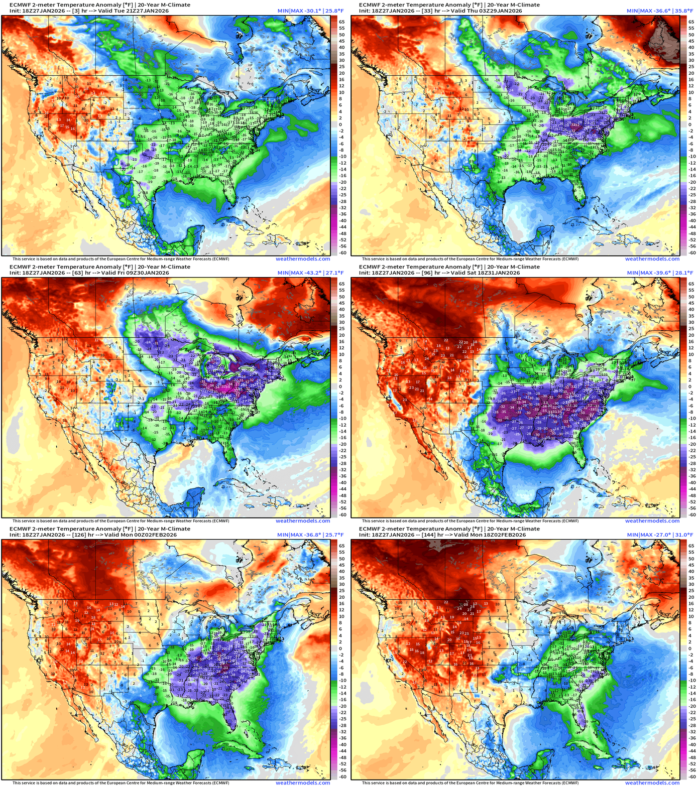
Bottom drops out again this weekend with Florida under threat of a devastating freeze with teens and 20s to Interstate 4 and potential for Miami to see low-30s.
The cold drains down the peninsula behind the powerful blizzard cyclone.
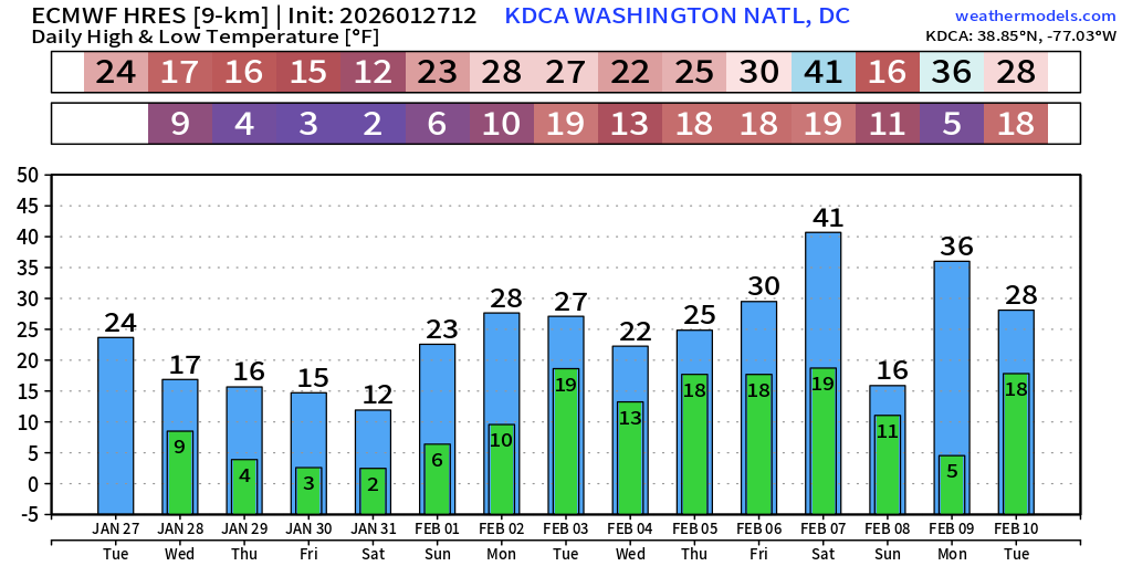
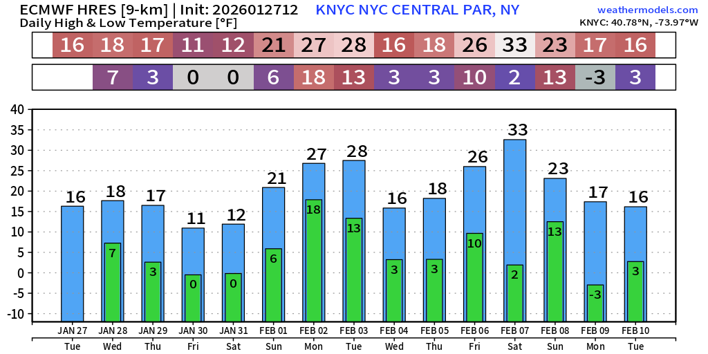
Temperatures Next 15-days in Washington DC and NYC: not much relief in sight
Low Temperatures Wednesday | 258 million freezing | Lower 48 avg: 16.3°F
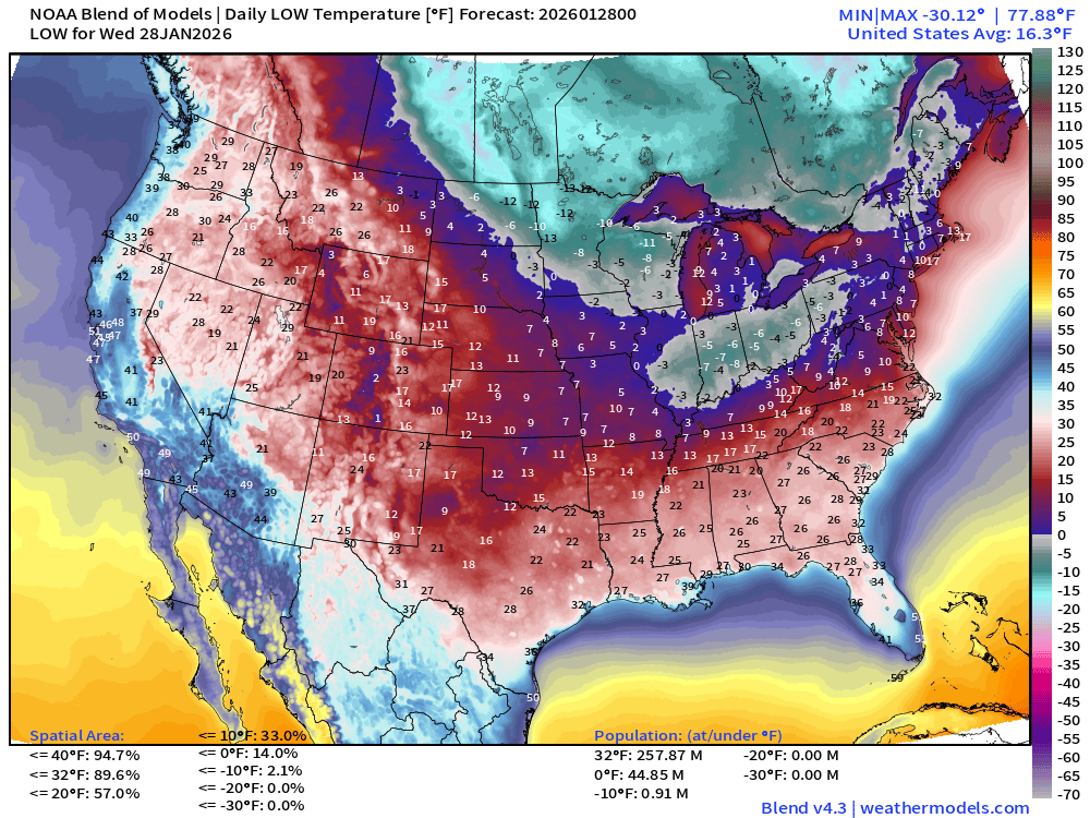
Very cold with 90% of the Lower 48 below freezing. 45 million population below zero.
High Temperatures Wednesday
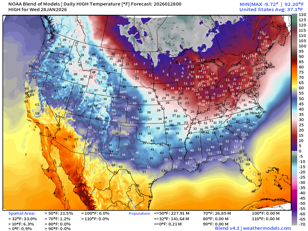
Still 142 million freezing during day, but warming underway across Texas and the South into the 40s and even 50s with sunshine. Only 27 million above 70°F
Low Temperatures Thursday
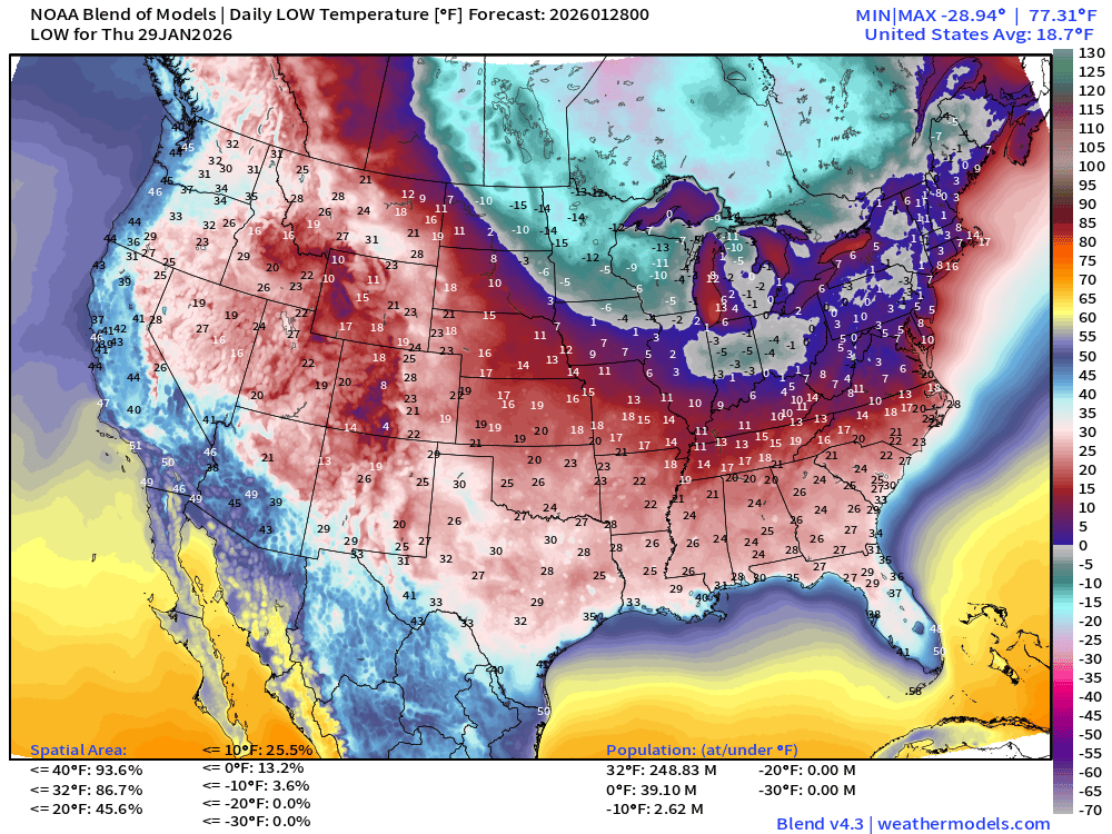
Another cold pool dips into the Midwest and Great Lakes with subzero temperatures along I-80 from central Illinois to western PA.
High Temperatures Thursday
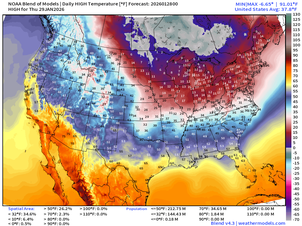
Midwest and Great Lakes remain frigid
Record Lows for Entire State of Florida on Sunday | Hard Freeze | Pipe Busting Cold
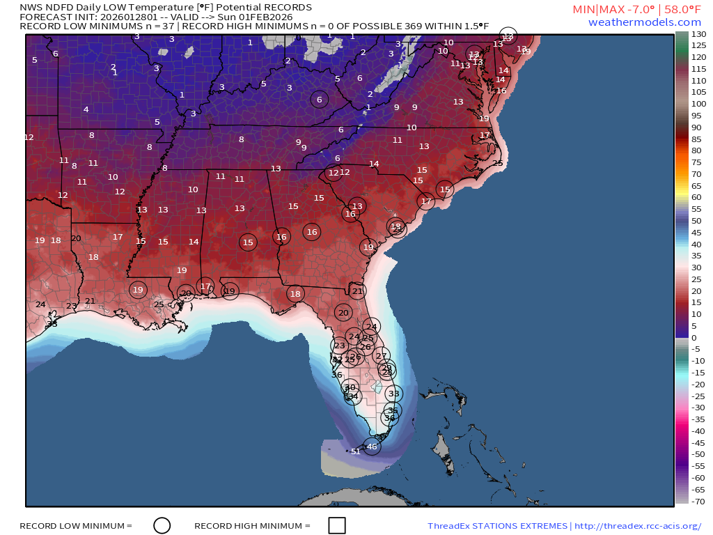
mid-20s in Orlando and low to mid 30s in South Florida.
ECMWF AIFS 18z | Precipitable Water Next 6-days
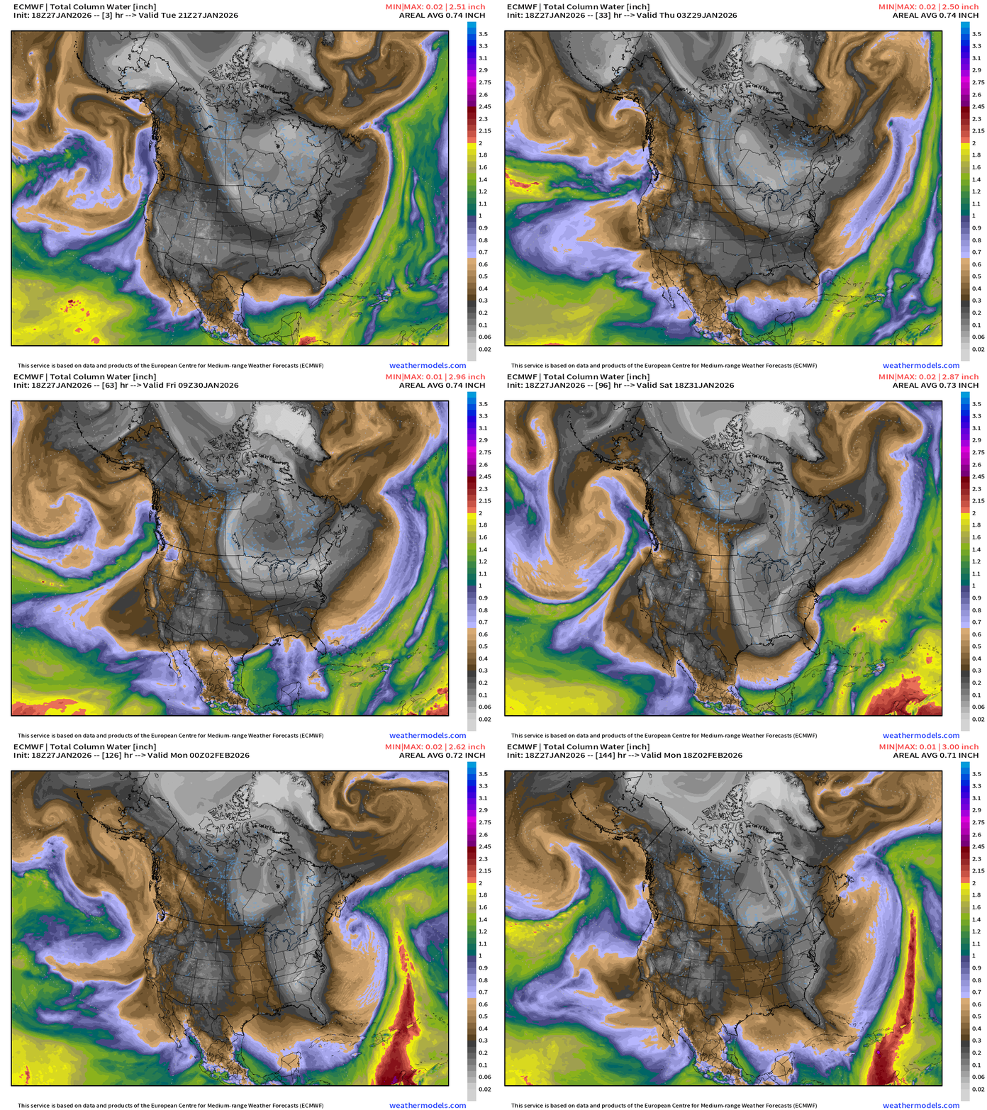
Cold front clears south Florida but then moisture returns to fuel our “bomb cyclone” Friday into Saturday. Bone dry Arctic air mass “flushes” right through South Florida into Sunday with perhaps the perfect angle to bring a freeze to the Everglades.
Flagship ECMWF 12z EPS | Temperature Anomaly | Next 15-days
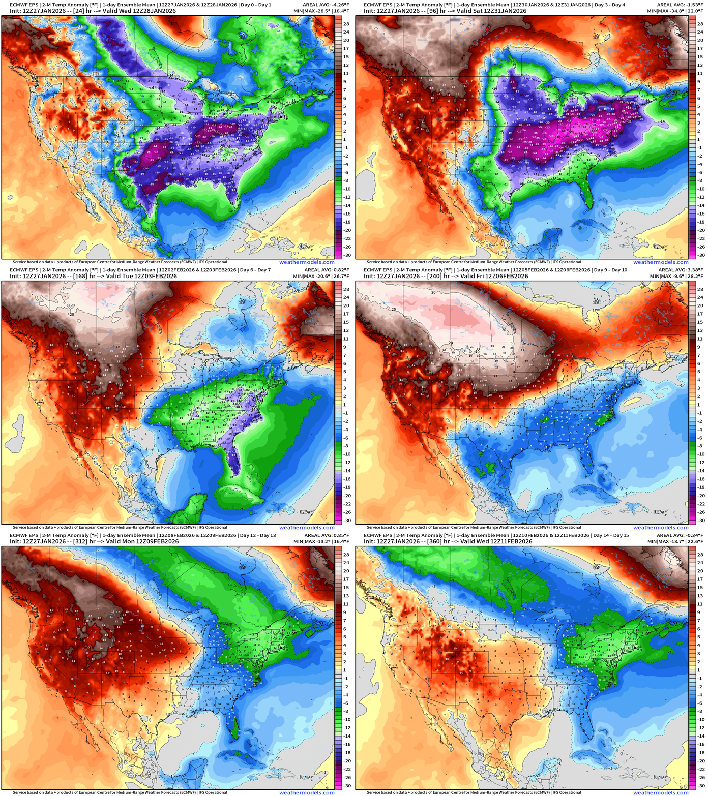
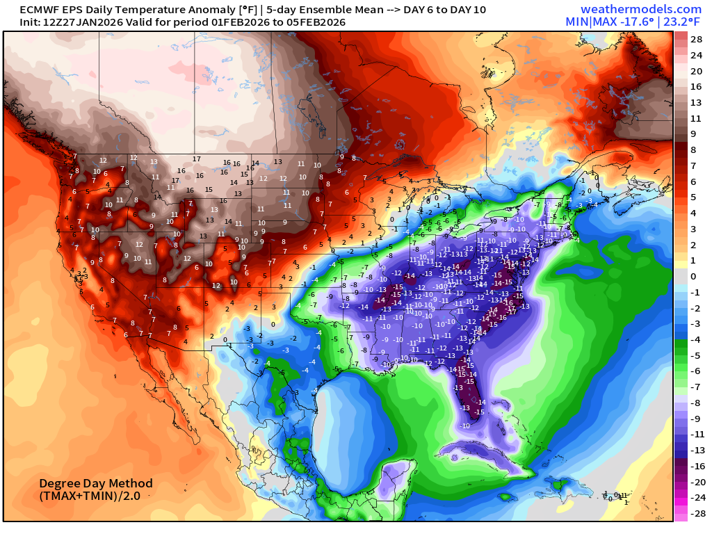
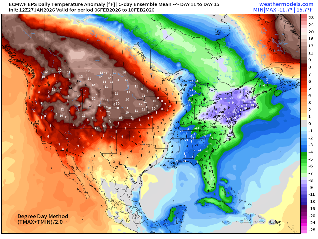
Looking into Days 11-15, there is an attempt to bring the westward warmth across the Rockies, but not so much … we may be seeing the opening up of the entire Arctic “ridge bridge” and Polar Vortex cold southward yet again for second 10-days of February.
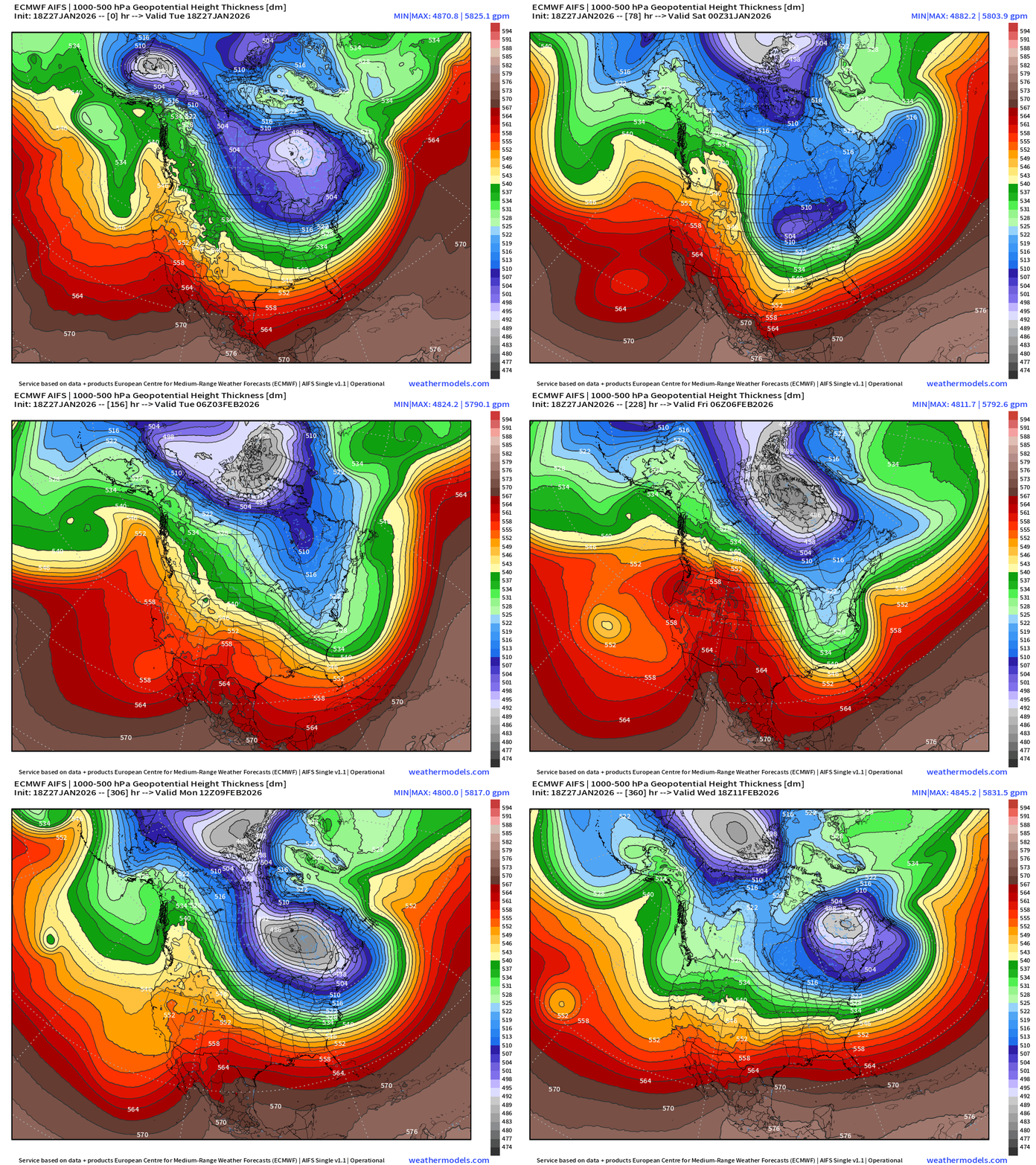
ECMWF AIFS-Single 18z | Height Anomaly (500 hPa) Next 15-days
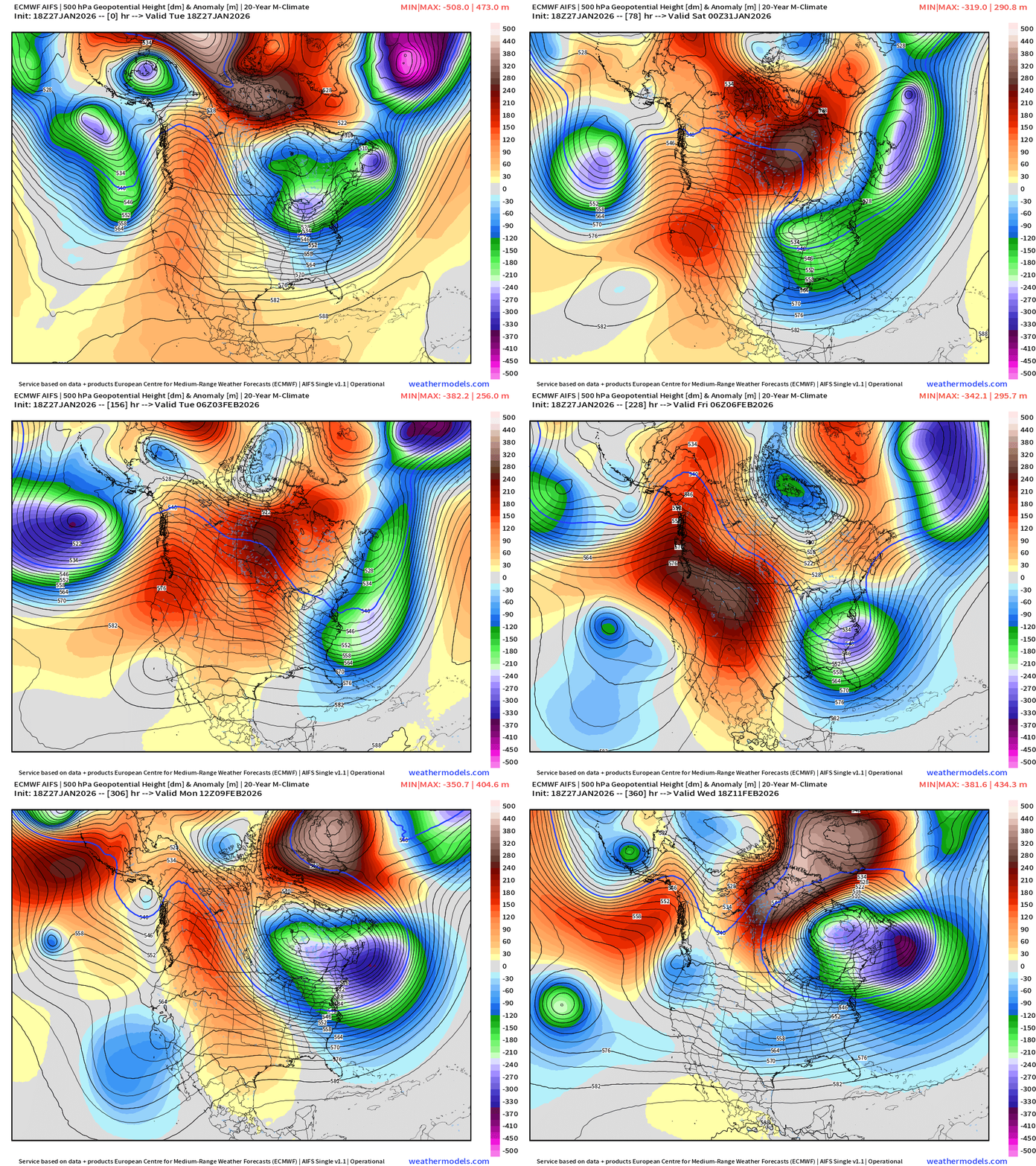
Incredible height anomaly associated with the first blizzard AND then a second one plausible off the Northeast at Day 10 with that PV anomaly remaining in NE Canada.
Thickness shows the “full load” polar vortex (gray) arriving to Hudson Bay into Days 10-12 and then spinning over Quebec.
ECMWF AIFS-Single 18z | Temperature (500 hPa) Next 15-days
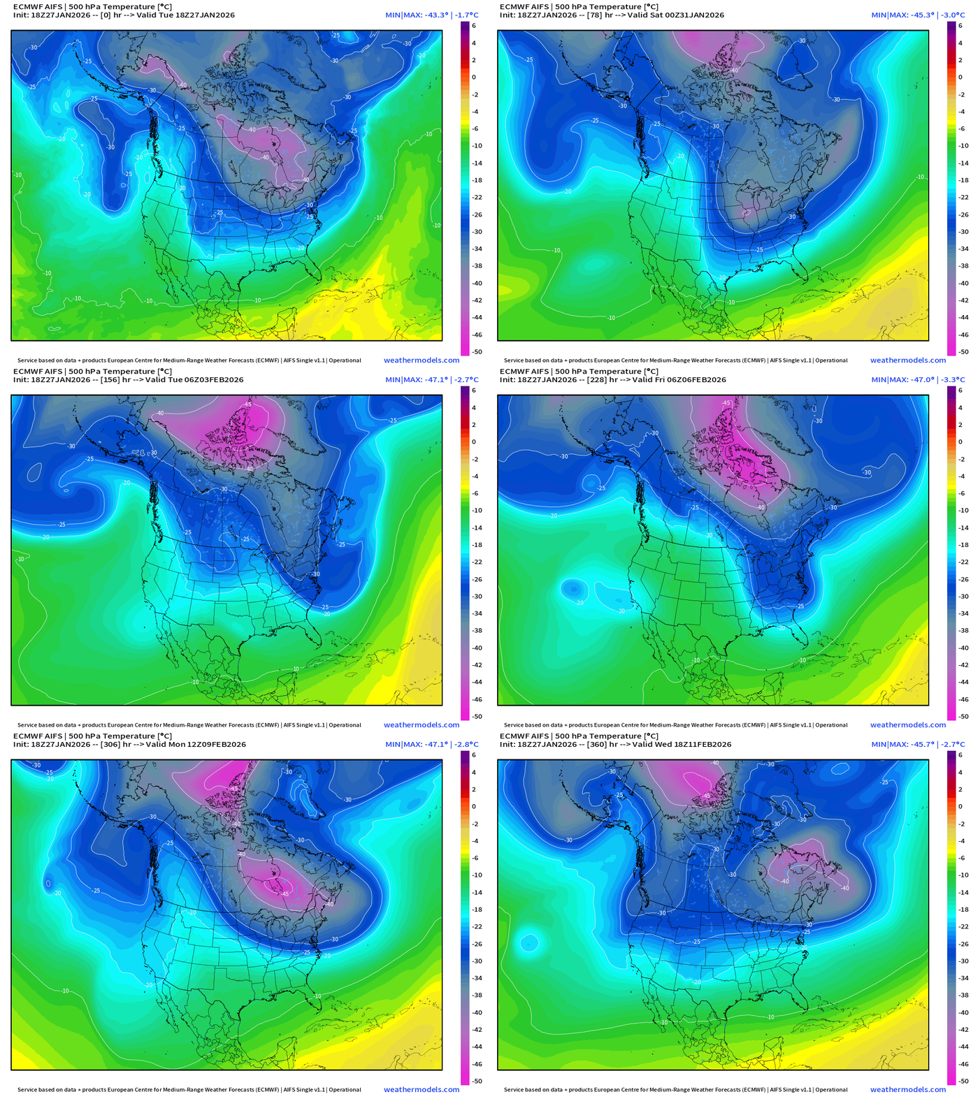
The temperature at 500 mb is the easiest way to highlight the “polar vortex” across North America with the coldest pool at -40°C (pink) with the -25°C contour usually associated with below freezing temperatures at 2-meters (surface).
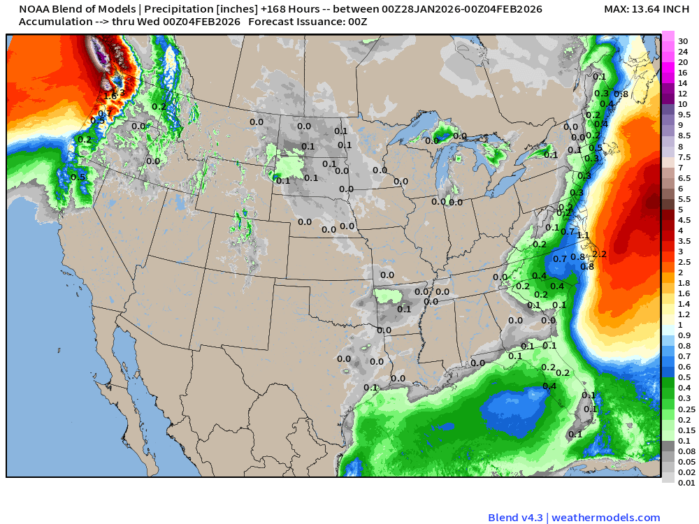
Blend of Models | 7 Days Precipitation Total
Blend of Models | Total Snowfall Next 7-Days
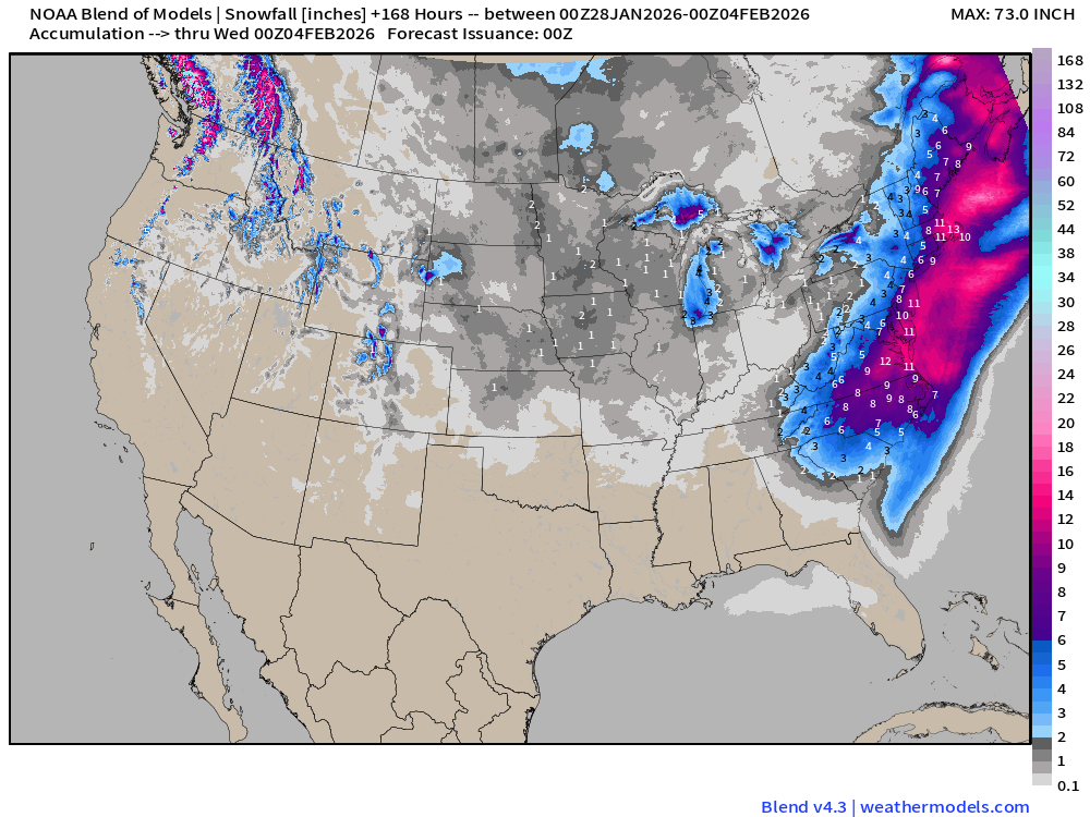
Blend of Models is on board with coastal snow — but since it’s an averaging of multiple models, it is likely way too wide/large with the snow swath. The EPS 18z median and IQ range are better in my opinion at this juncture.
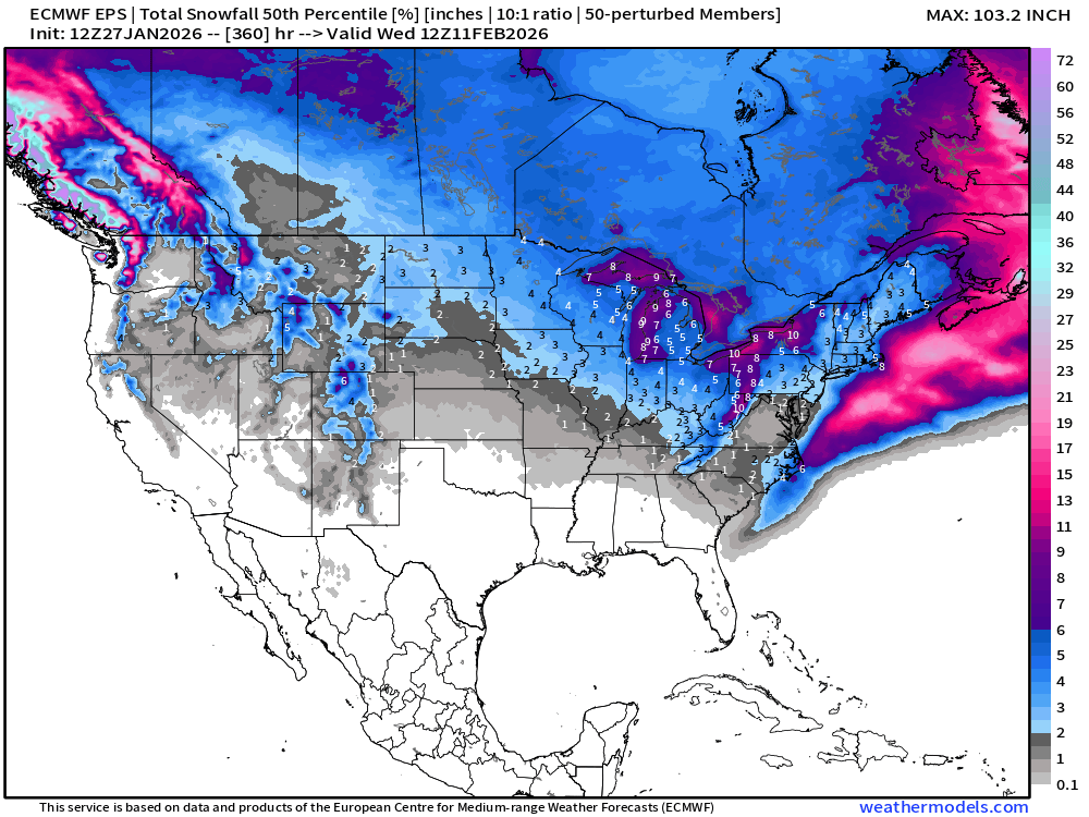
ECMWF EPS 12z | Ensemble Median Snowfall Next 15-days
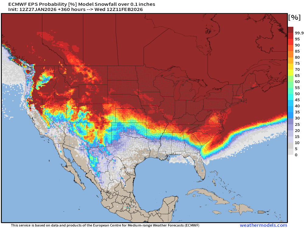
Probability of some Snowfall (0.1”) in next 15-days
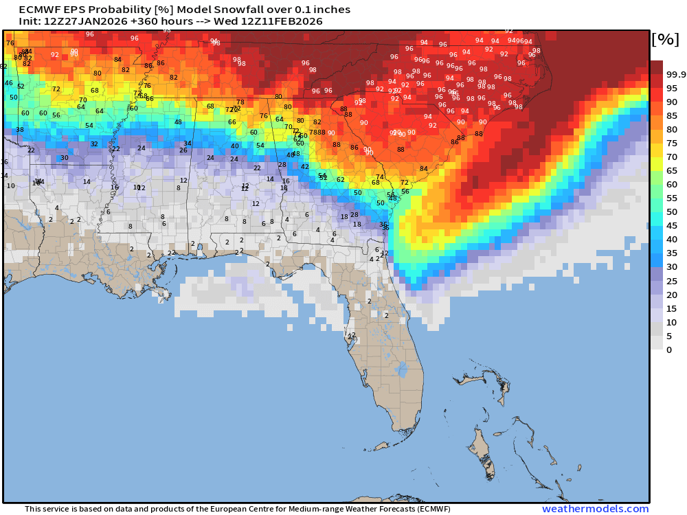
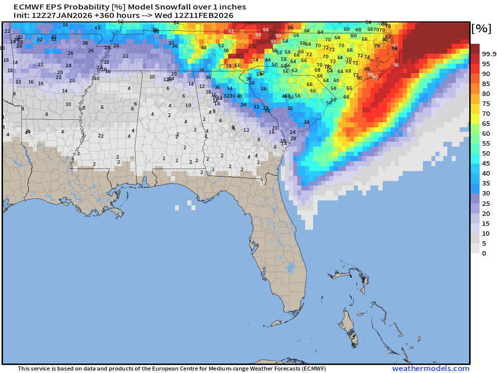
Florida snowfall chances are small, but creeping upward to ~10% to 20% over the panhandle, and maybe 10% around Tampa Bay
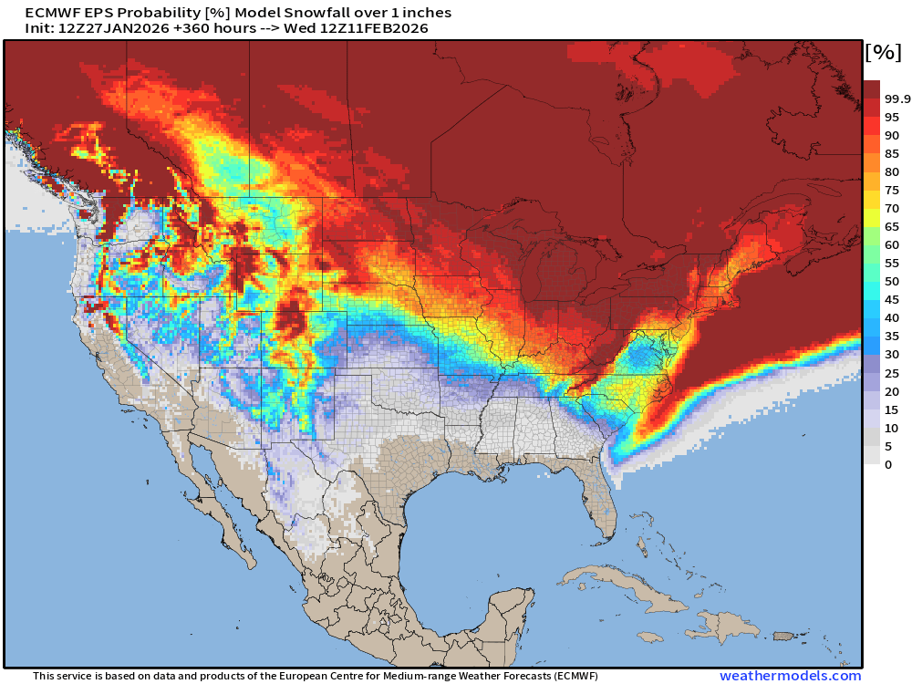
Probability of 1-inch Snowfall in next 15-days
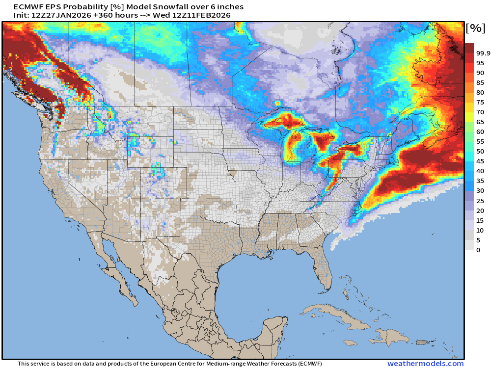
Probability of 6” of Snowfall next 15-days
Temperature Anomaly | Next 15-days | ECMWF EPS 12z
5-Day Chunk #1 | Temperature Anomaly | Jan 27 - Jan 31
5-Day Chunk #2 | Temperature Anomaly | Feb 1 - Feb 5
5-Day Chunk #3 | Temperature Anomaly | Feb 6 - Feb 10
Maps sourced from weathermodels.com designed and innovated by yours truly! Please subscribe there for real-time access to the newest maps, charts from all of the weather models including ECMWF and AIFS, NOAA AI-GFS/AI-GEFS
- Milepost
- 851 · laid 2026-01-28T02:49:31.051000Z
- Source
- https://weather.substack.com/p/january-27-2026-tuesday-frigid-winter
- Digest
- 29e8ab351ed9ba55a8d59eec4421811c7c8019d53c2e705d7d923313ce189912
- Machine
- JSON