December 14, 2025 Sunday Evening Winter Weather
Warming trend this week with main storm track staying in Canada
December 2025 was the 5th-warmest December in the 131-year national record (1895–2025), at 37.8°F against a 1991–2020 normal of 34.3°F (+3.5°F).
December 2025 was the 37th-driest December in the 131-year national record (1895–2025), at 2.0in against a 1991–2020 normal of 2.5in (-0.5in).
NOAA/NCEI Climate at a Glance, contiguous United States. This is the observed record for the month, not a score of anything said in this piece — the forecast ledger begins 2026-08-17 and cannot reach earlier posts.

Observed Snowfall Last 7-Days
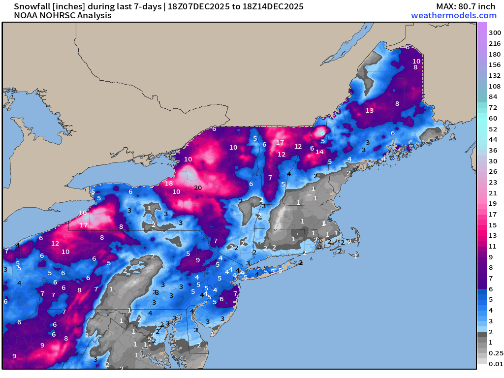
As snowfall reports come in — model data and radar indicated precipitation is merged together into the optimal estimate of “snowfall” — which is somewhat different than what may be measured on the ground 6-12 hours later due to compaction. I saw 0.5” of QPF at NYC but only 2.7” of snowfall recorded in Central Park. Regardless, in meteorology, when you take an observation at a point, you cannot say much else about neighboring locations due to representativeness in time and space. When a weather balloon is launched, it is measuring the atmosphere at that time and along the trajectory of the balloon, not 3-hours later.
In general, our QPF forecasts are pretty good — but snowfall error creeps in with the snow-to-liquid ratios (SLR) or the fluff factor dependent upon the temperature of the lowest layers of the column above the surface. I think we did pretty well with the “jackpots” in central coastal New Jersey.
Still the entire “winter” lies ahead — so don’t be too concerned about the warm-up on the way into Christmas. We actually need to thaw out a little bit for the economy —> shopping and travel.
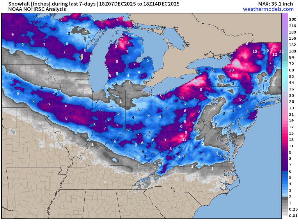
HRRR 18z | Next 48-Hours through Tuesday 7 AM ET
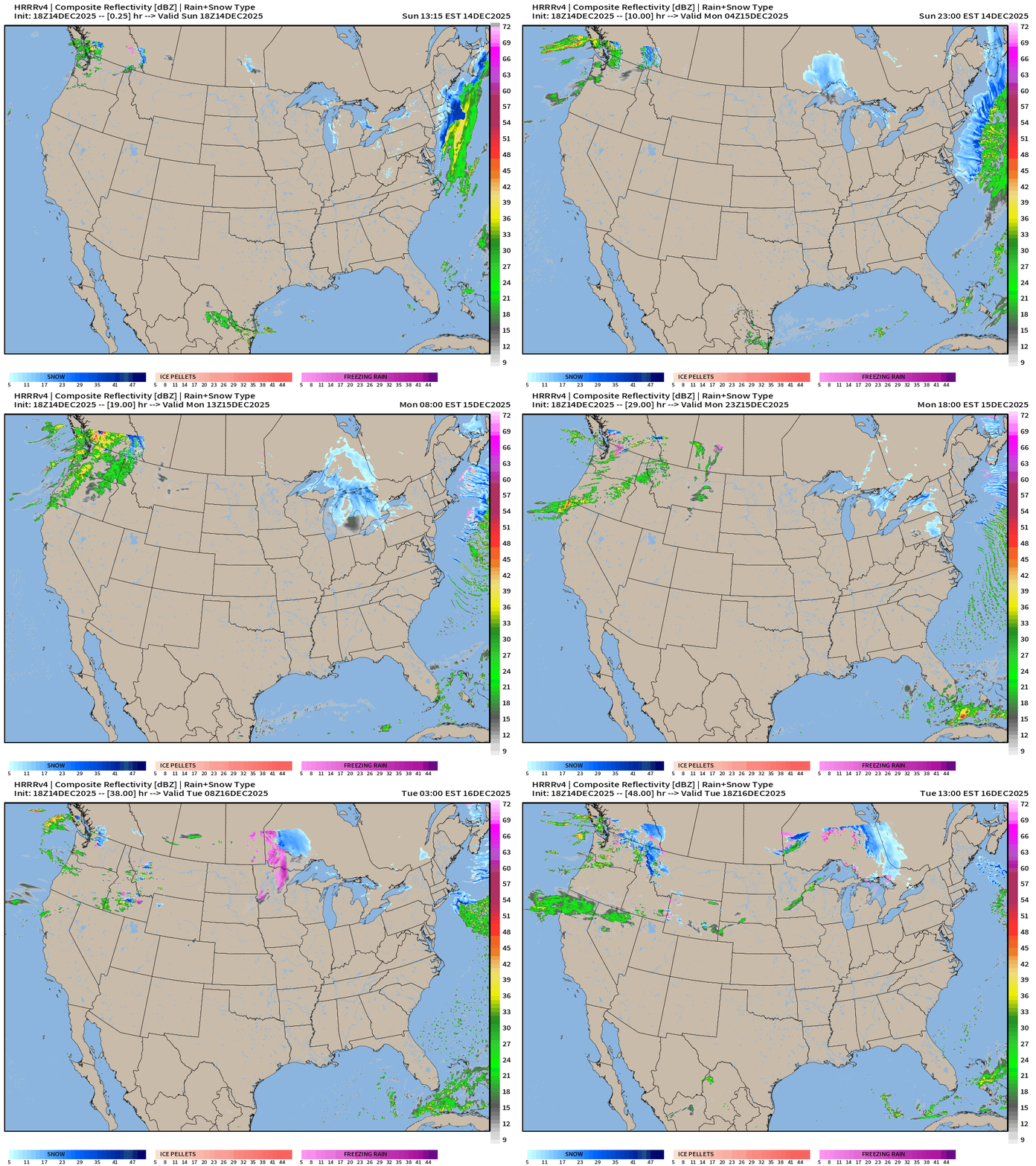
Once the Nor’easter moves away, all that remains is brutally cold air for another morning or two across the Great Lakes and Northeast —> Lake Effect snow machine.
Another storm system (atmospheric river) crashes into the Pacific Northwest — just the next one in a long parade of storm systems that cruise across southern Canada
Storm System Parade Across Canada | Next 6-days
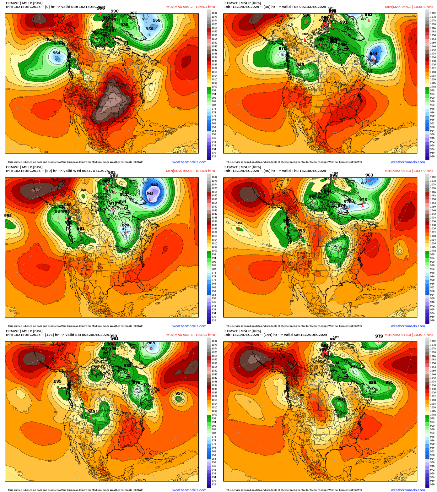
Multiple impressive storms cross Canada — with pressure in the 970s or 980s but remain north of the U.S. border and work with a much warmer air mass to the south — within the growing mid-level ridge. The main “Polar Vortex” retracts into Canada and only minor excursions or lobes will be affecting the Lower 48 for the coming 10-14 days. However, even with the PV locked up (mostly) there is still opportunity for brief mini-Arctic blasts for a day or two as part of these powerful storm systems.
Precipitation Type | Weather Next 6-days | ECMWF 18z
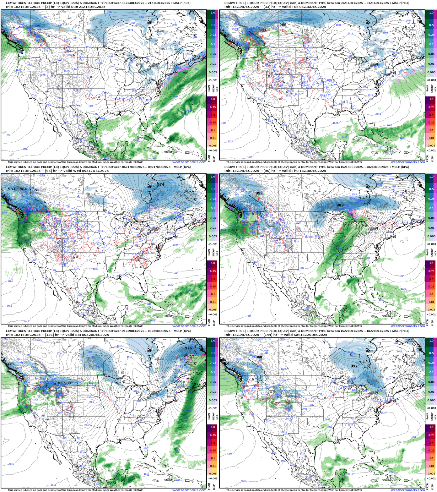
Headlines Sunday Evening
Storm system moves away from Northeast — cold air behind it.
Significant warming trend into upcoming week — finally. It can’t stay cold forever.
However, as the ridge builds across the Lower 48 from coast-to-coast into Christmas, we still will need to deal with a few bouts of Arctic air in the Great Lakes and Northeast — so not exactly “shorts and t-shirt” for Santa Claus, just not brutally cold — like this weekend.
Warm Up on the Way — Briefly Interrupted Friday
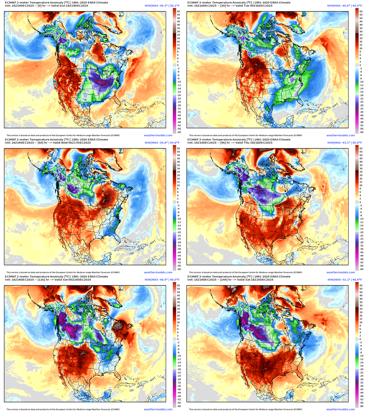
There is a MASSIVE Alaska / West Canada cold pool that is continually replenishing due to offshore flow from interior Arctic environs … circulation around a strong Aleutian Low spinning in the Gulf of Alaska. Typically this air can flood southward down the U.S. West Coast with troughs, but that avenue is foreclosed due to the honking ridge blocking its escape. So, the cold air looks for opportunity with passing storm systems to hitch a ride across the continent.
Storms Will Have a LOT of Wind Energy | Friday Morning
Will talk more about these powerful storms on Monday … but we’re in for some huge wind makers in the Northeast … example here is a 975 mb low pressure over Quebec ahead of a Polar Vortex lobe —> which has access to some of that Canadian Arctic cold pool.
High Temperatures Next 8-days | Until Tuesday, Dec 23rd
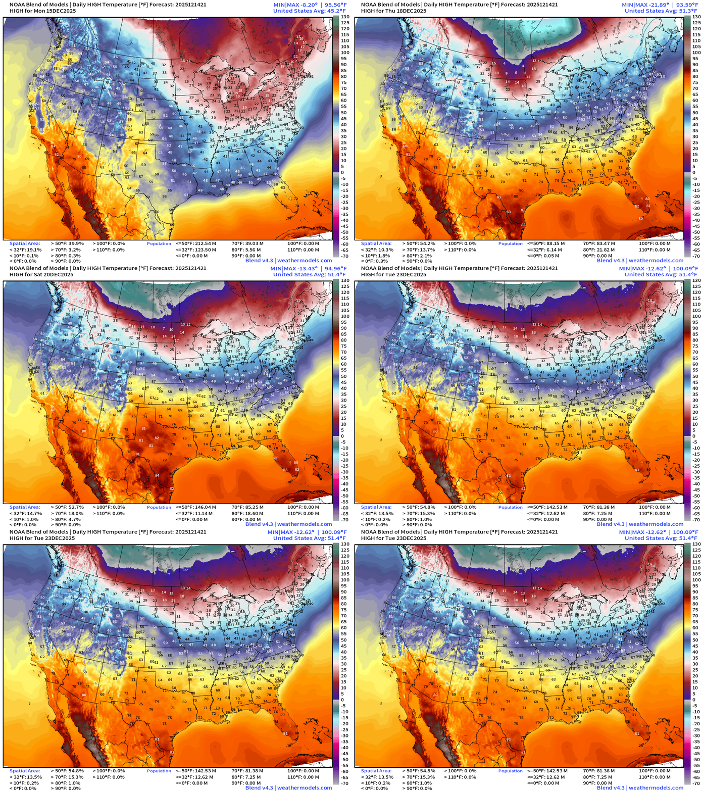
Warming trend after Monday — well deserved after an abnormally very cold start to December.
Holiday Coupon code 50% off Annual Upgrade 🎅
ECMWF 18z Precipitable Water Next 6-days | My favorite parameter
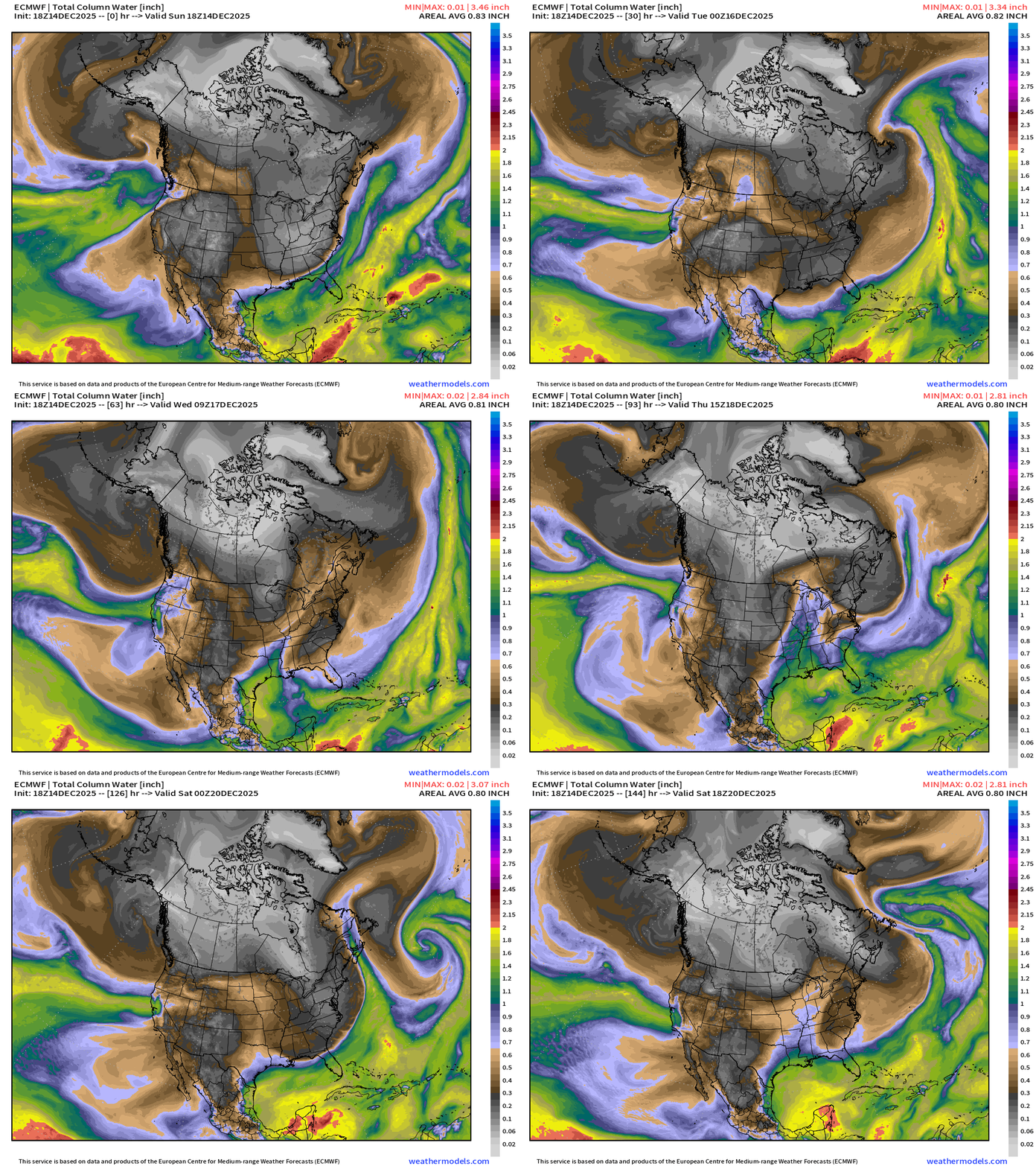
White colored precipitable water = absence of moisture = cold/polar air mass spills into the Southeast by Monday morning, but relief — warmer/moist air from Pacific Northwest races across the Lower 48.
Parade of “atmospheric rivers” continue for the West Coast — and sink a bit further south across Oregon into even Central California by next weekend
Another “Arctic blast” scheduled for Friday — but hopefully not as a severe — and certainly very brief as the warmer westerly flow from the Pacific wins the battle.
ECMWF 12z | Temperature Anomaly | Next 15-days
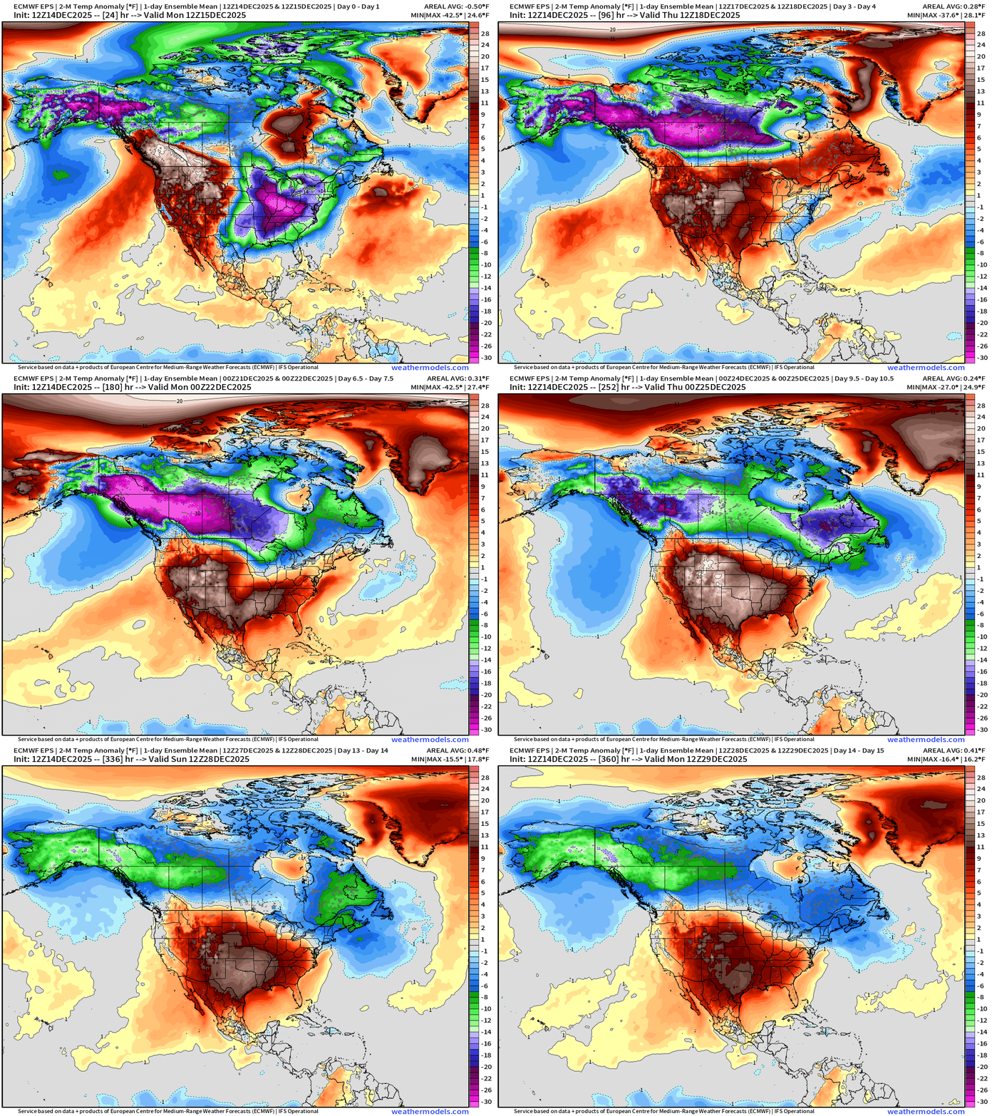
Flagship European model ensemble solution for temperature anomaly next 15-days
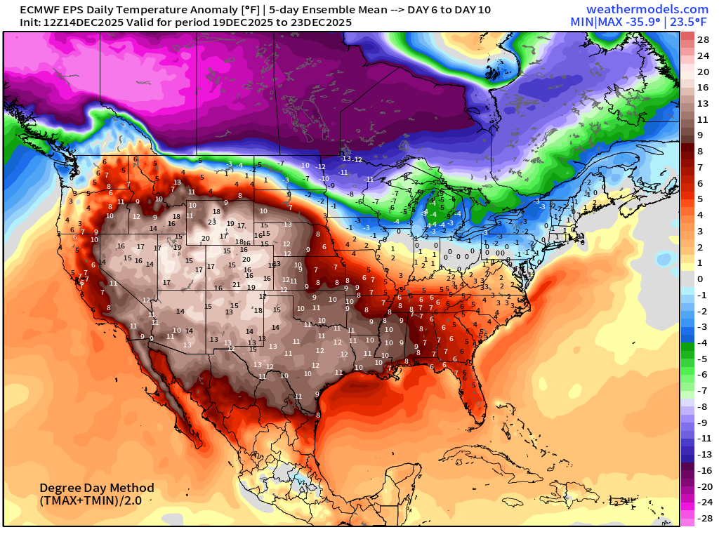
The Lower 48 settles into a “Blow Torch” much above normal temperature pattern — eventually — once we can finally block off the “polar vortex” by this next weekend.
Temperatures surge to well above normal for much/all of the Lower by Christmas — BUT still some uncertainty about the Great Lakes and Northeast — especially with proximity to the “Polar Vortex” and any lobes that may be dragged south by passing storm systems.
RTMA | 24 Hour Temperature Change | 7:45 PM ET
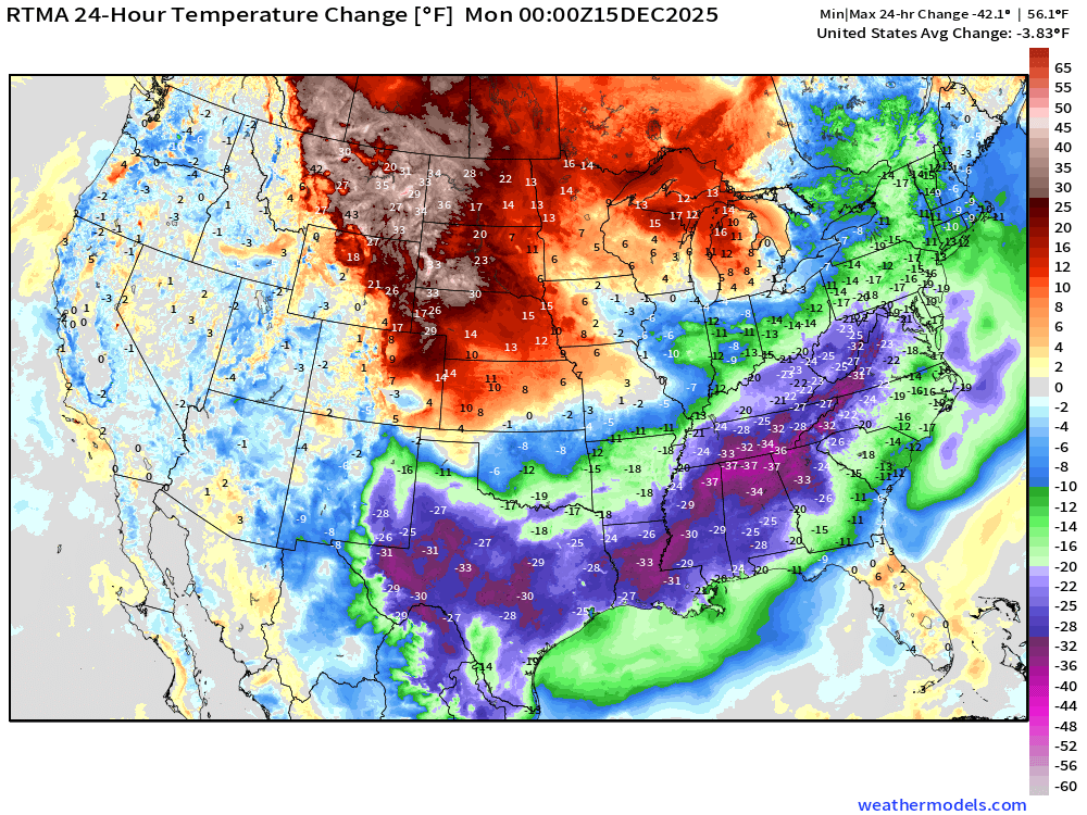
Temperatures upwards of 37°F colder from Texas to Mid-Atlantic, including Atlanta.
RTMA | Current Temperature Analysis | 7:45 PM ET
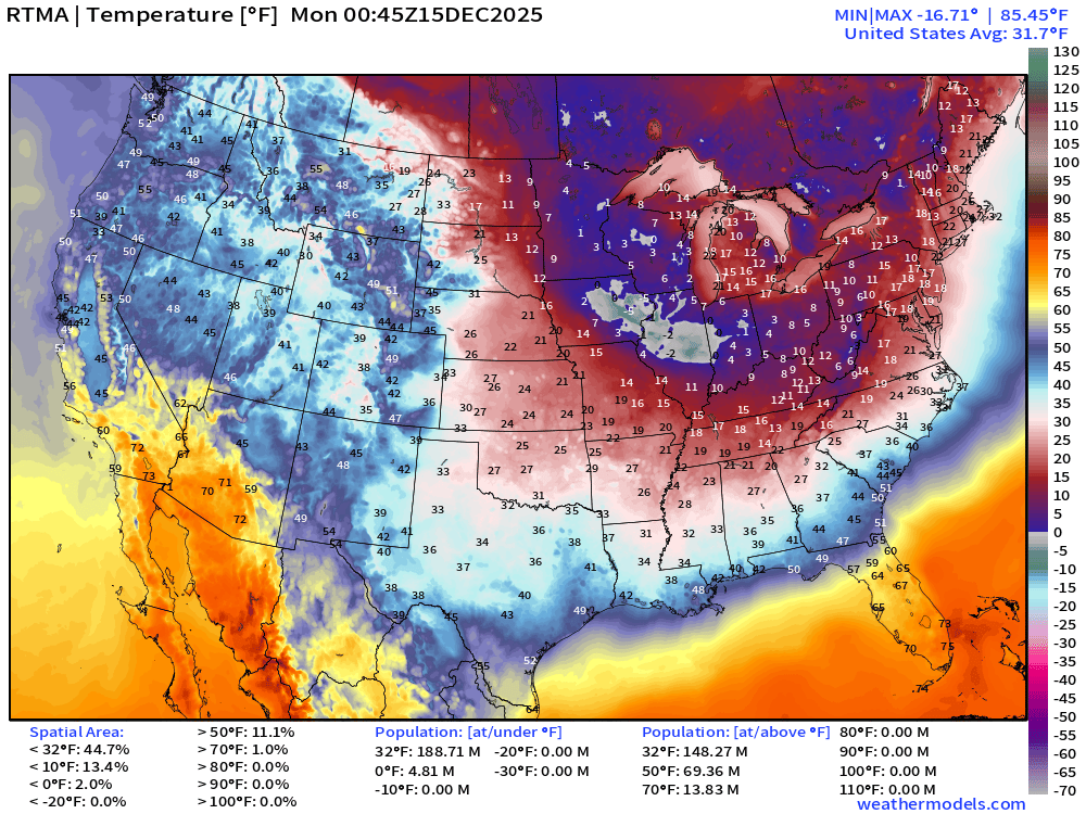
Average Lower 48 temperature was 31.7°F with about 189 million below freezing.
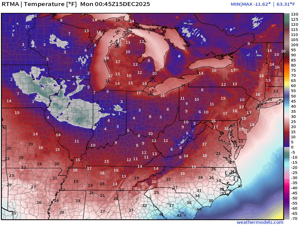
About 5 million population below 0°F
Temperature Anomaly | 7:45 PM ET
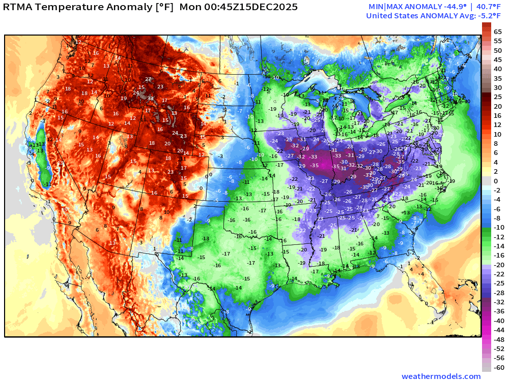
Lower 48 Temperature Anomaly was -5.2°F BELOW normal
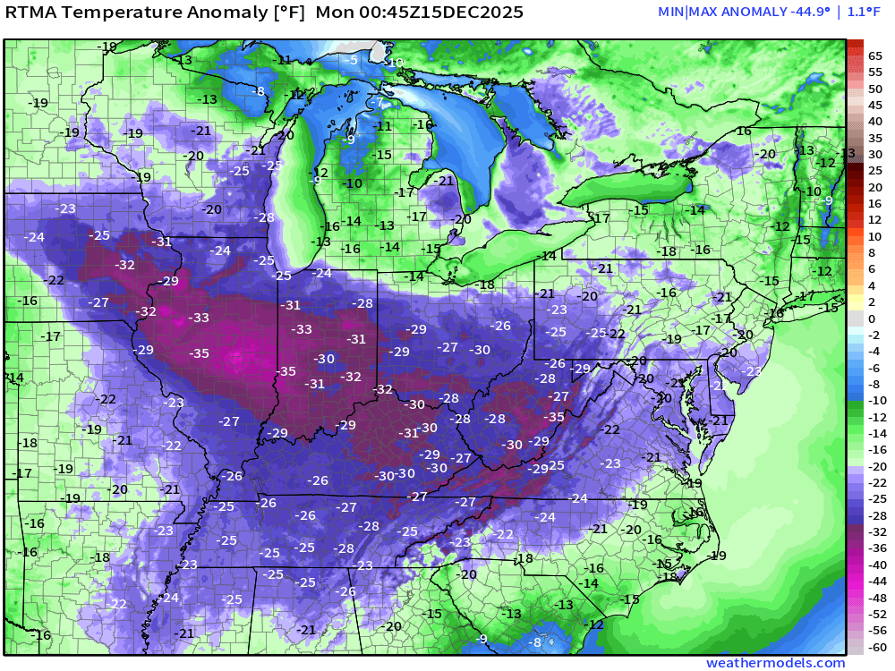
Coldest temperatures in the 35°F to 45°F below normal range in central Illinois
Monday Low Temperatures
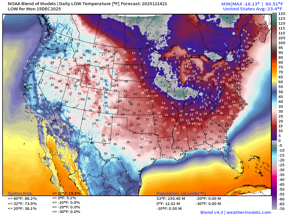
More than 230 million below freezing but only 13 million subzero — so “could be a lot worse” for sure — but it’s only Mid-December.
Teens into Alabama, Mississippi, and North Georgia. Atlanta may only escape in the low-20s at the airport. 20s into North Florida = frigid.
Monday High Temperatures
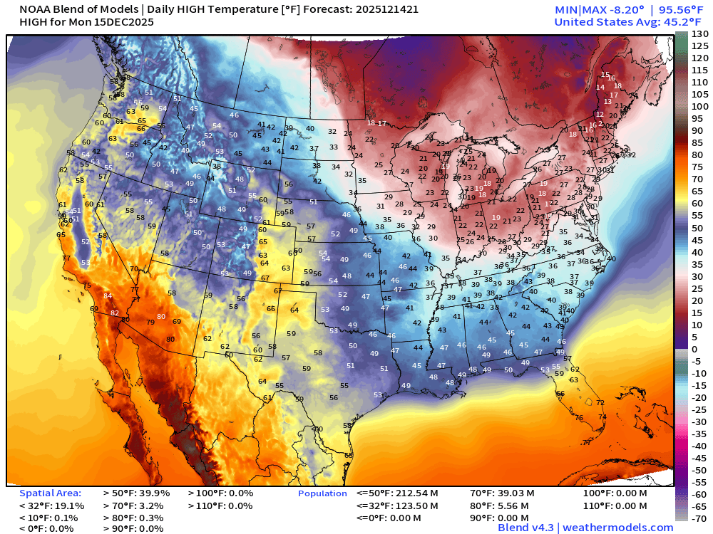
Improvement — slightly. We’ll start the warmup from a chilly baseline in the Great Lakes only in the 20s.
Tuesday High Temperatures
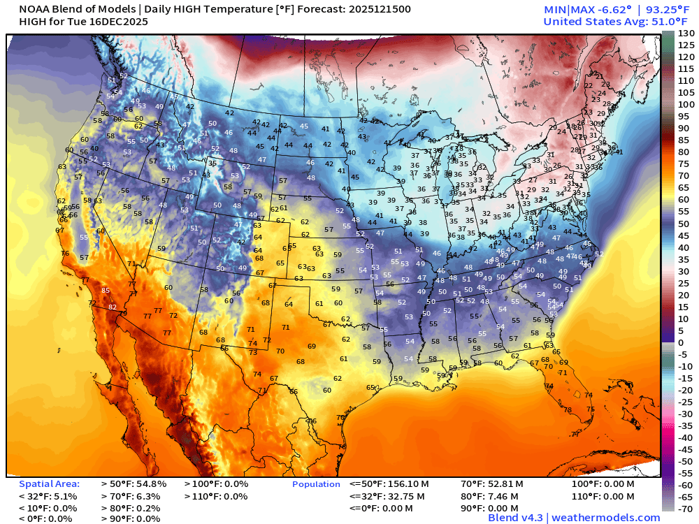
Much warmer — add another 10°F across the board east of the Rockies
NWS Precipitation Next 72-hours
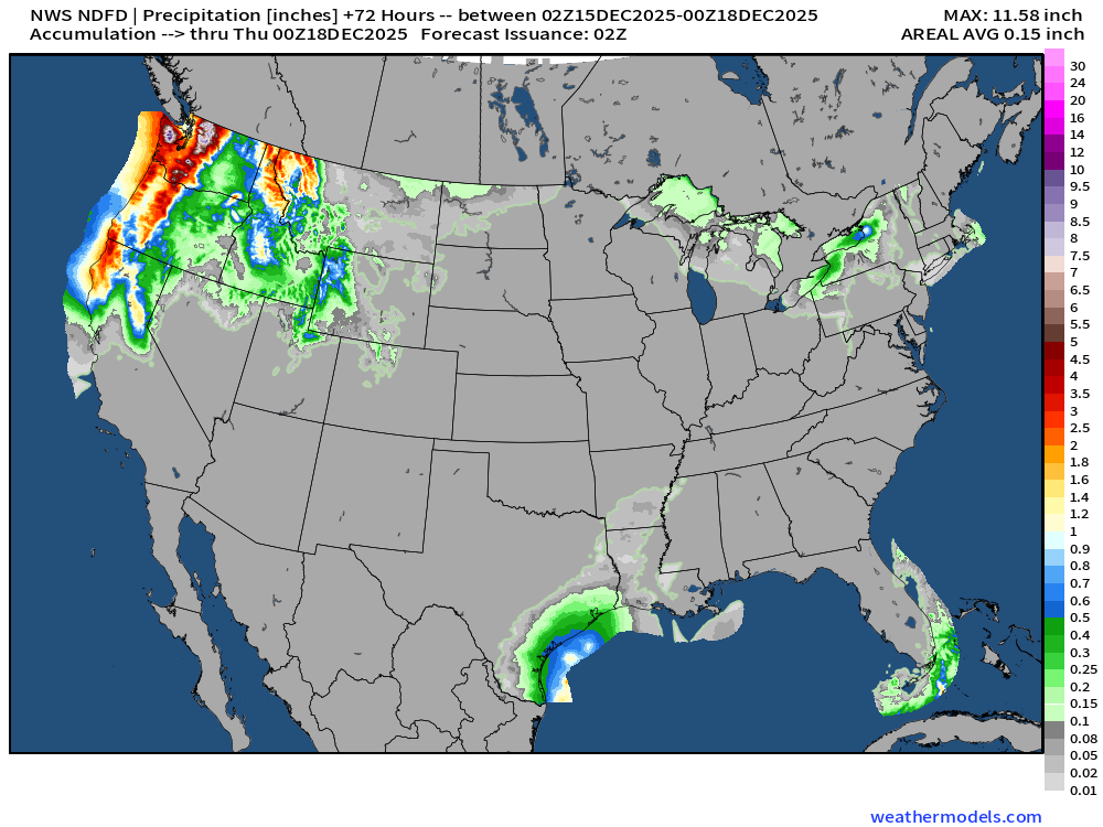
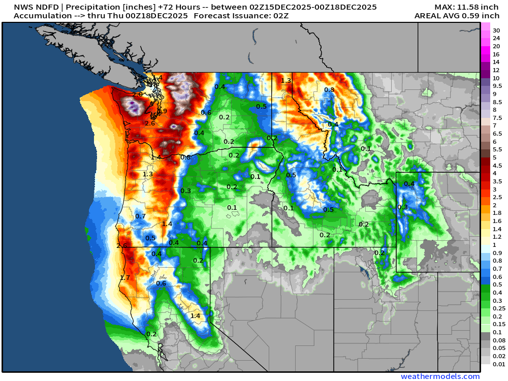
NWS Snowfall Next 72-hours
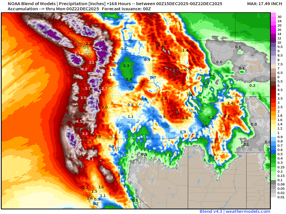
Blend of Models | 7 Days Precipitation Total
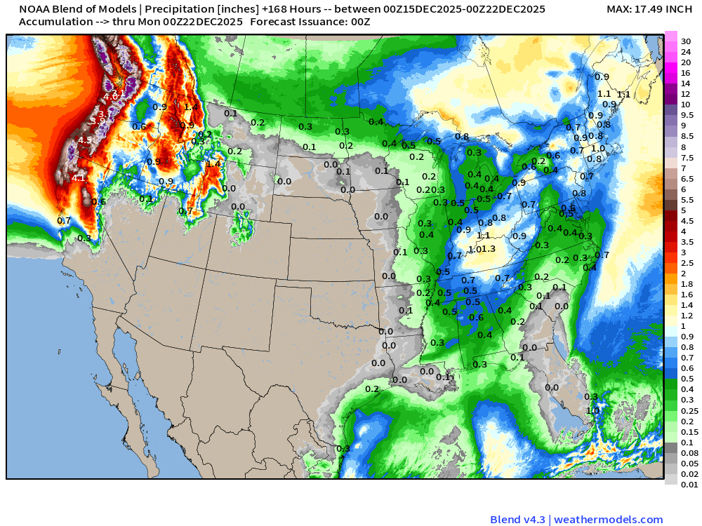
Enormous rainfall totals across the Pacific Northwest continue for next 7-days at least.
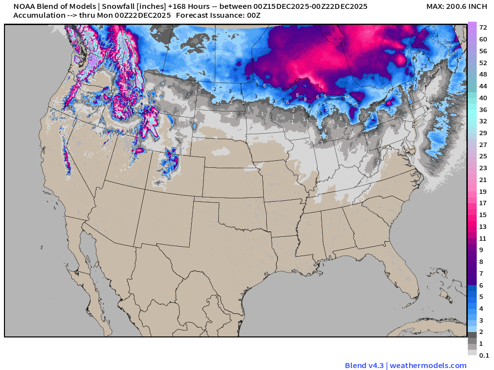
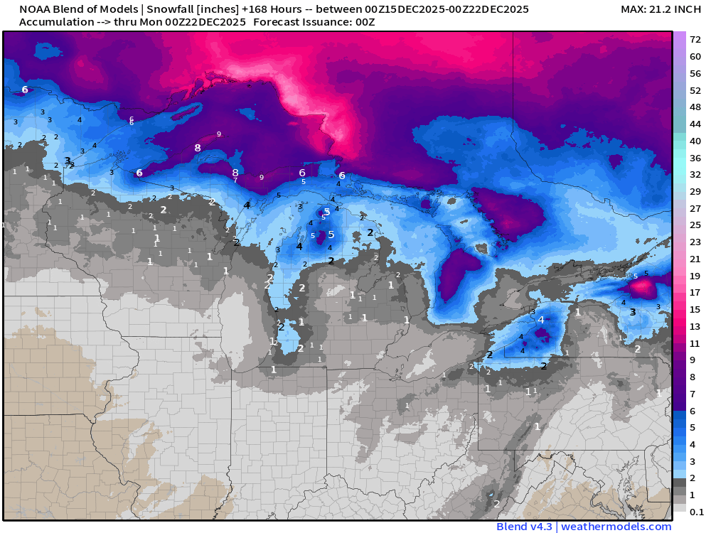
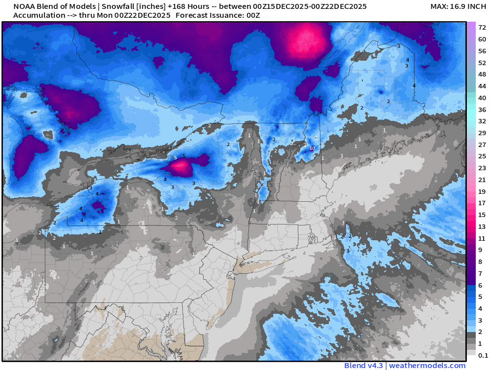
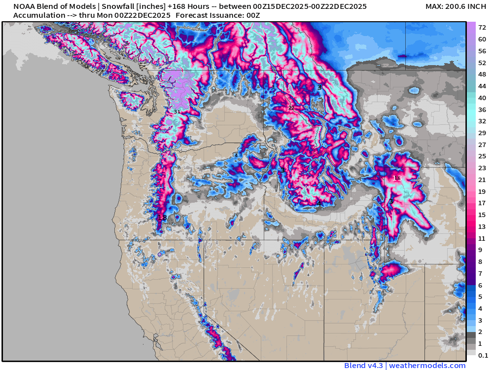
Blend of Models | Total Snowfall Next 7-Days
ECMWF AIFS-Single 18z | Height Anomaly (500 hPa) Next 10-days
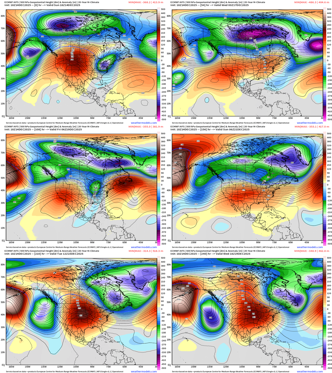
One more “polar vortex” trough into this upcoming weekend — Days 6-8 … and then the ridge builds across the Rocky Mountains and forms a long-lasting block.
No doubt about the intensity of this Lower 48 Blocking Ridge — so we next must determine when this pattern “breaks down” and we shake the bag, spin the wheel, or whatever to determine where the overall upper-level patterns goes into the weekend after Christmas
Day 10 EPS Full Physics ECMWF 12z | EPS Ensemble Mean and Control
Day 10 AIFS Ensemble Mean + AIFS Single
ECMWF 12z | Integrated Vapor Transport Next 10-days
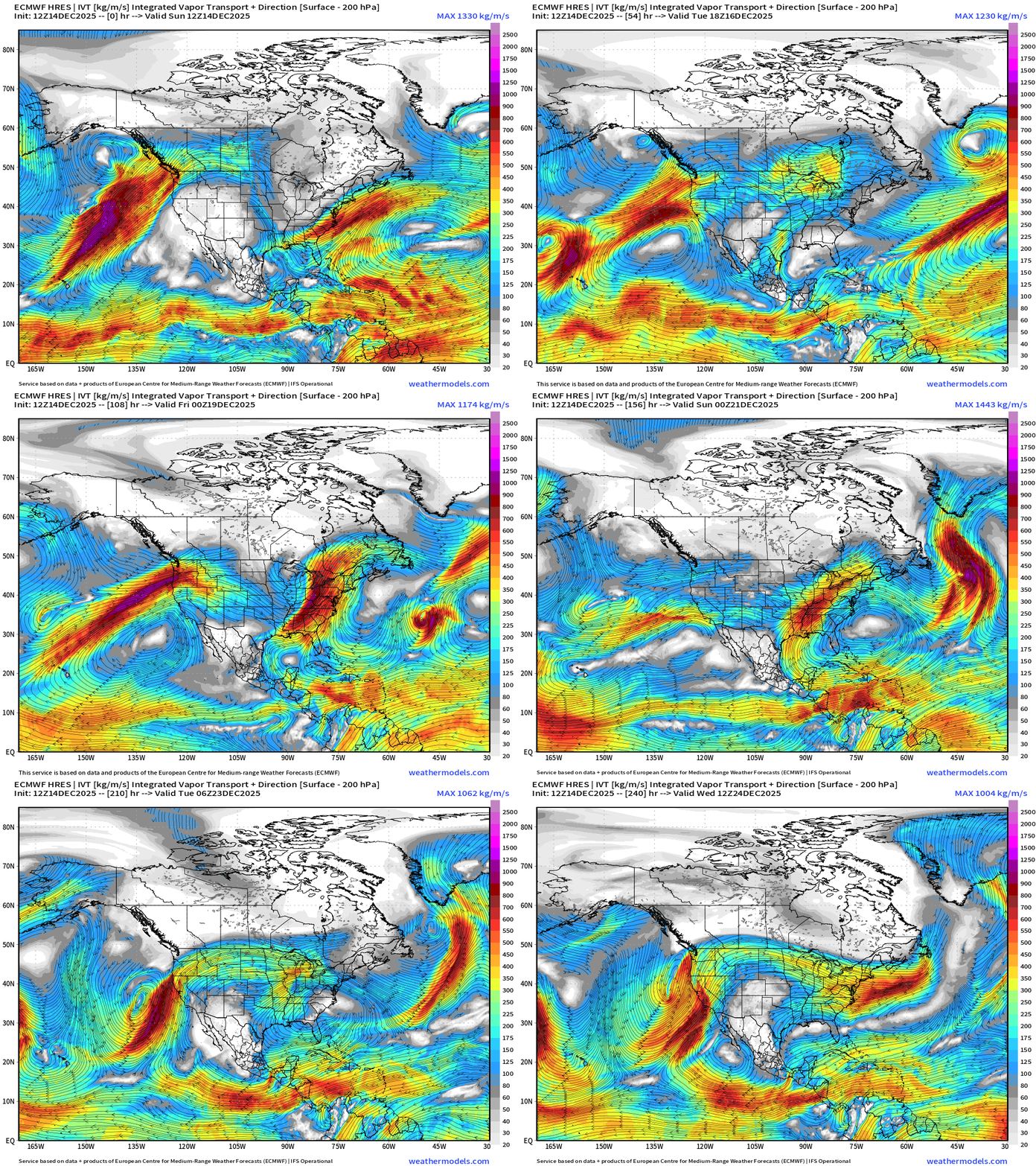
Parameter used for monitoring “atmospheric rivers” usually along the U.S. west coast, but the idea works well for many other areas — highlighting midlatitude storm systems with warm conveyor belts (moisture plumes)
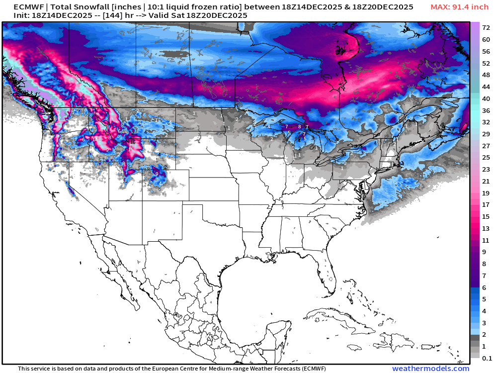
ECMWF 18z | Snowfall | Next 6-days
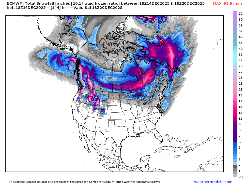
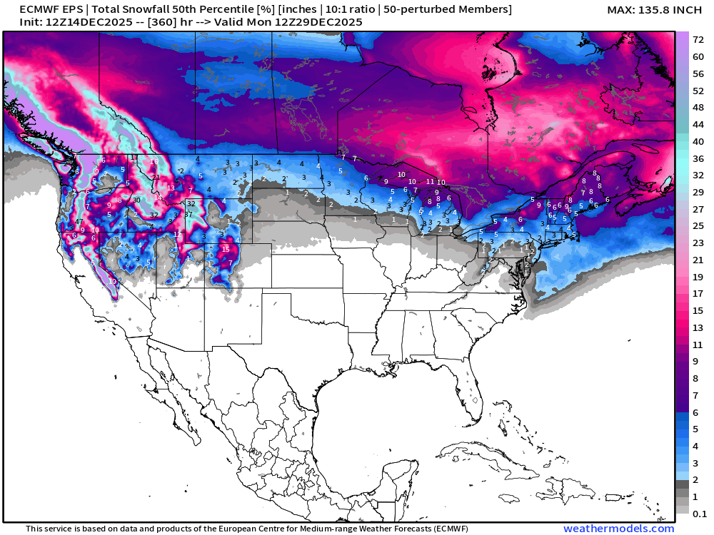
ECMWF EPS 12z | Ensemble Median Snowfall Next 15-days
Next 15-days Temperature Anomaly | Ensemble Mean to December 28
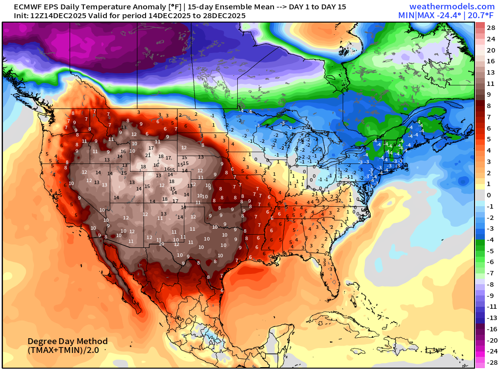
Temperature Anomaly | Next 15-days | ECMWF EPS 12z
5-Day Chunk #1 | Temperature Anomaly | Dec 14 - Dec 18
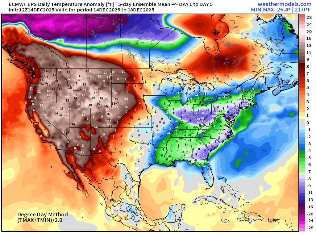
5-Day Chunk #2 | Temperature Anomaly | Dec 19 - Dec 23
5-Day Chunk #3 | Temperature Anomaly | Dec 24 - Dec 28
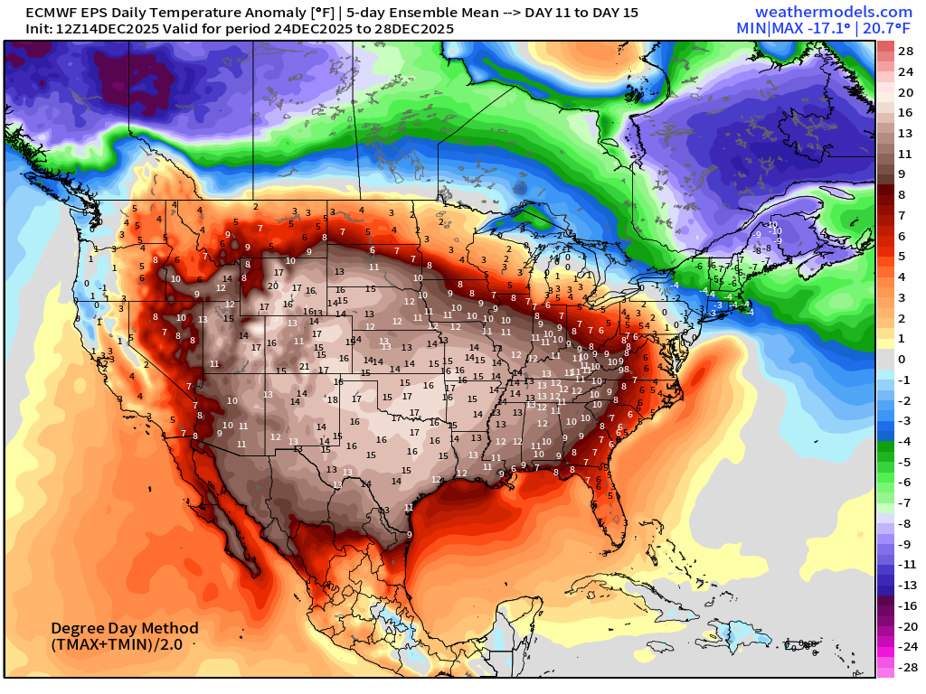
The Northeast well below normal (?)
Maps sourced from weathermodels.com designed and innovated by yours truly! Please subscribe there for real-time access to the newest maps, charts from all of the weather models including ECMWF and AIFS, NOAA AI-GFS/AI-GEFS
Active coupon codes:
- Milepost
- 815 · laid 2025-12-15T02:29:07.841000Z
- Source
- https://weather.substack.com/p/december-14-2025-sunday-evening-winter
- Digest
- 7876700cac50866d934ca0e0b6813b28792e135d356094829aae60cb2a75de59
- Machine
- JSON