December 10, 2025 Wednesday Evening Winter Weather
Extreme cold this weekend across Midwest will flood off East Coast
December 2025 was the 5th-warmest December in the 131-year national record (1895–2025), at 37.8°F against a 1991–2020 normal of 34.3°F (+3.5°F).
December 2025 was the 37th-driest December in the 131-year national record (1895–2025), at 2.0in against a 1991–2020 normal of 2.5in (-0.5in).
NOAA/NCEI Climate at a Glance, contiguous United States. This is the observed record for the month, not a score of anything said in this piece — the forecast ledger begins 2026-08-17 and cannot reach earlier posts.

Headlines Wednesday Evening
AP News Coverage of Atmospheric River —> Blend of unusual weather conditions brings trillions of gallons in persistent rain to the Northwest
These storms “have been supercharged by the chain of events that began two weeks ago” much farther west than Hawaii, Maue said. —> MJO
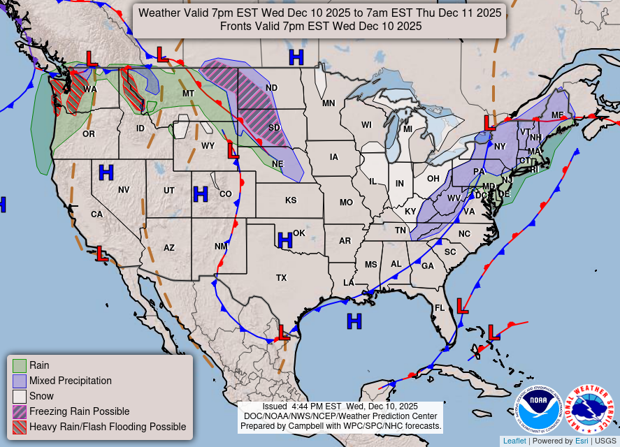
Still watching an Alberta Clipper as it scoots off New England will develop into a stronger storm system that could have enough moisture and proximity to the coast to drop a significant band of snowfall Sunday — Monday.
Atmospheric river events into the Pacific Northwest —> boatloads of precipitation
Strong Western U.S. ridge remains anchored — and firmly in charge for the next 10-14 days (at least) — and this ridging will expand eastward to block off the Arctic air in Canada likely into Christmas — but there is plenty of time for this plan to fall apart. Indeed, the ridge would be weakest in the Great Lakes and Northeast allowing for the polar vortex lobes to sideswipe a huge population.
VERY COLD — this weekend across the Midwest/Great Lakes peaking this Sunday.
California Central Valley STILL socked in with low clouds and fog/mist with very cool temperatures (40s) due to high pressure induced inversion layer — similar to the “wedge” that we see in Atlanta from easterly flow across the Appalachians
Current Frontal Boundaries and Weather into Thursday morning
HRRR 18z | Next 48-Hours through Thursday 1 PM ET
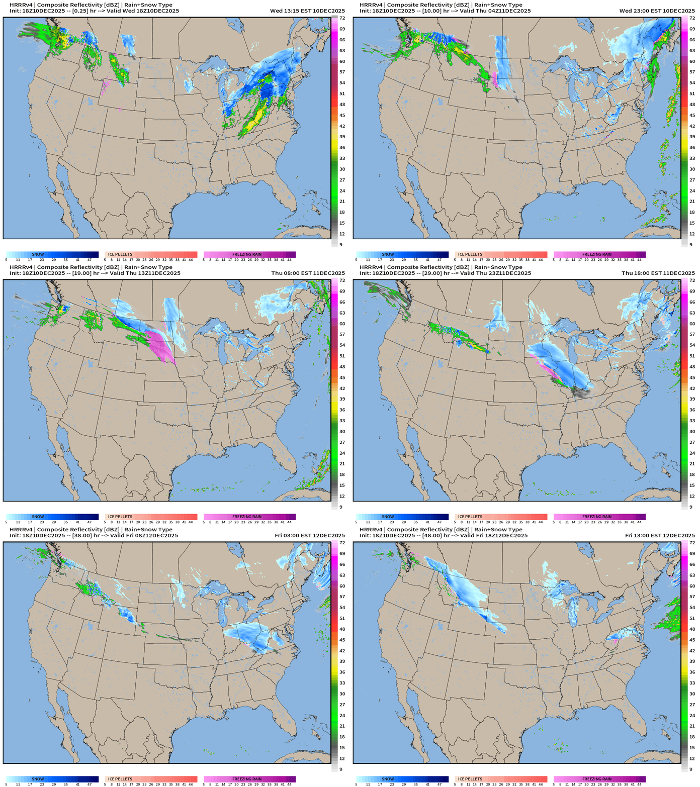
Alberta Clipper heading through the Northeast
Another one on its heels for Thurs-Friday
Major Atmospheric river crashes into Washington: 5 trillion gallons of precipitation just in WA —> Experiment with Grok to format an atmospheric river explainer in HTML in 5-minutes, rather than 1-hour+
Precipitation Type | Weather Next 10-days | ECMWF 12z
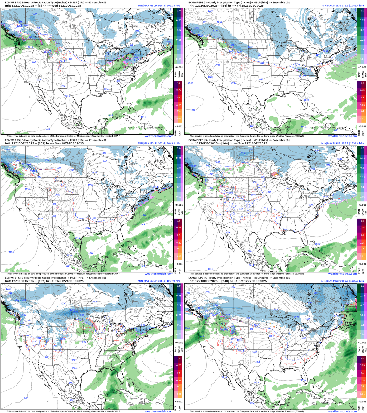
Storm track is up and over the western ridge —> so anything that develops has difficulty tapping into Gulf of Mexico or Subtropical Pacific moisture feeds
Low Temperatures Next 9-days | Until Friday, Dec 19th
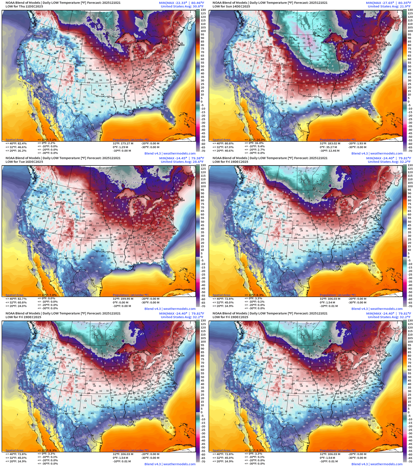
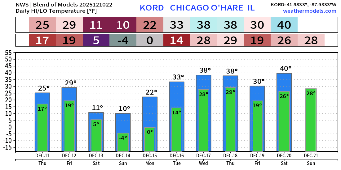
Coldest mornings will be Sat/Sun/Mon across the Midwest and Great Lakes including Chicago at -4°F
ECMWF 18z Precipitable Water Next 6-days | My favorite parameter
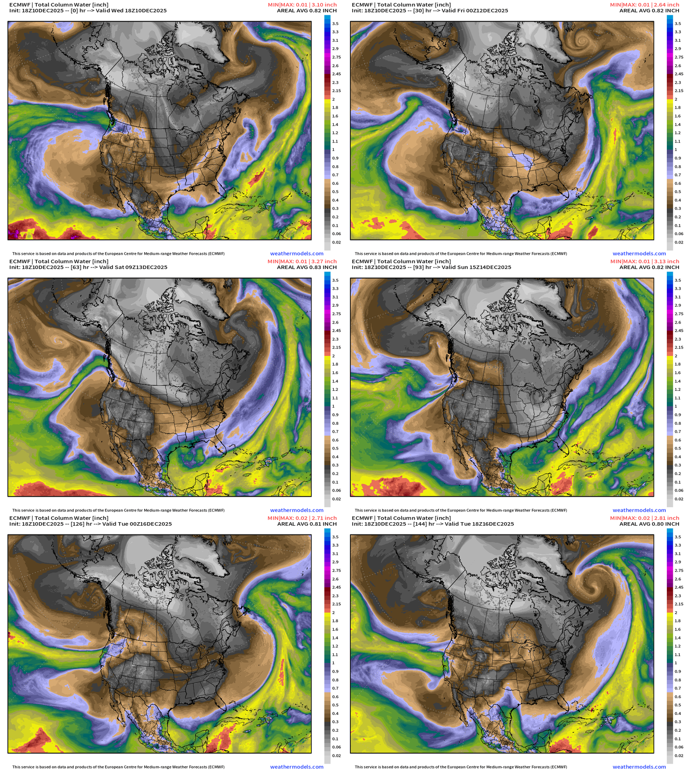
A zonally oriented atmospheric river system will pour huge plume of moisture into the Pacific Northwest. The Cascades and Rocky Mountains extract most of the moisture but some does cross into the Midwest to feed the parade of Alberta Clippers.
Another powerful storm system centered in the Gulf of Alaska by early next week yields another perhaps Category 5 atmospheric river.
White colored precipitable water = absence of moisture = cold/polar air mass surges southeast out of Western Canada into the Midwest into this weekend.
Watching a potential Winter Storm Sun-Mon from an Alberta Clipper vorticity max reaching offshore New England
Temperatures | Current to Next 15-days
Temperature Anomaly | Next 15-days
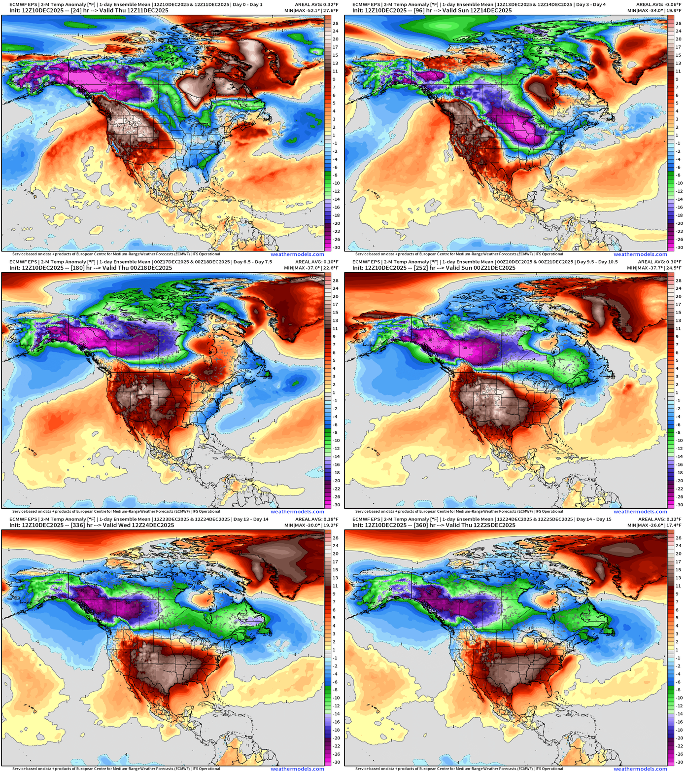
Flagship European model ensemble solution for temperature anomaly next 15-days
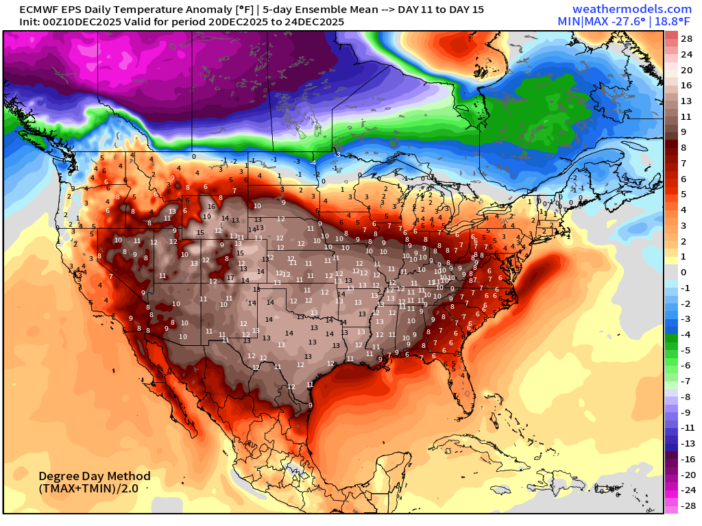
Into Days 10-15, the cold pool retracts into Alaska as the number of members with strong Lower 48 ridging increases — completely wiping out the Arctic cold influence. But we’ll need to watch the advance/retreat along the Canadian Border to see if this ridge can hold firm.
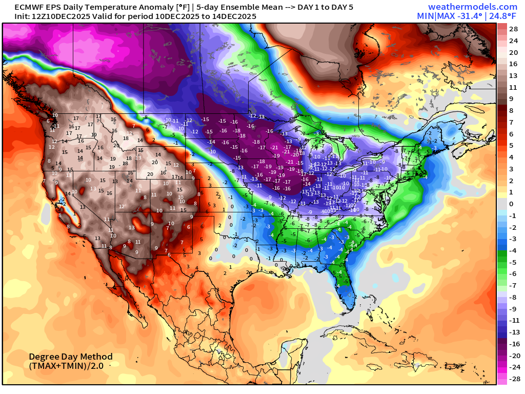
Temperature Anomaly Next 6-days | Into Saturday afternoon
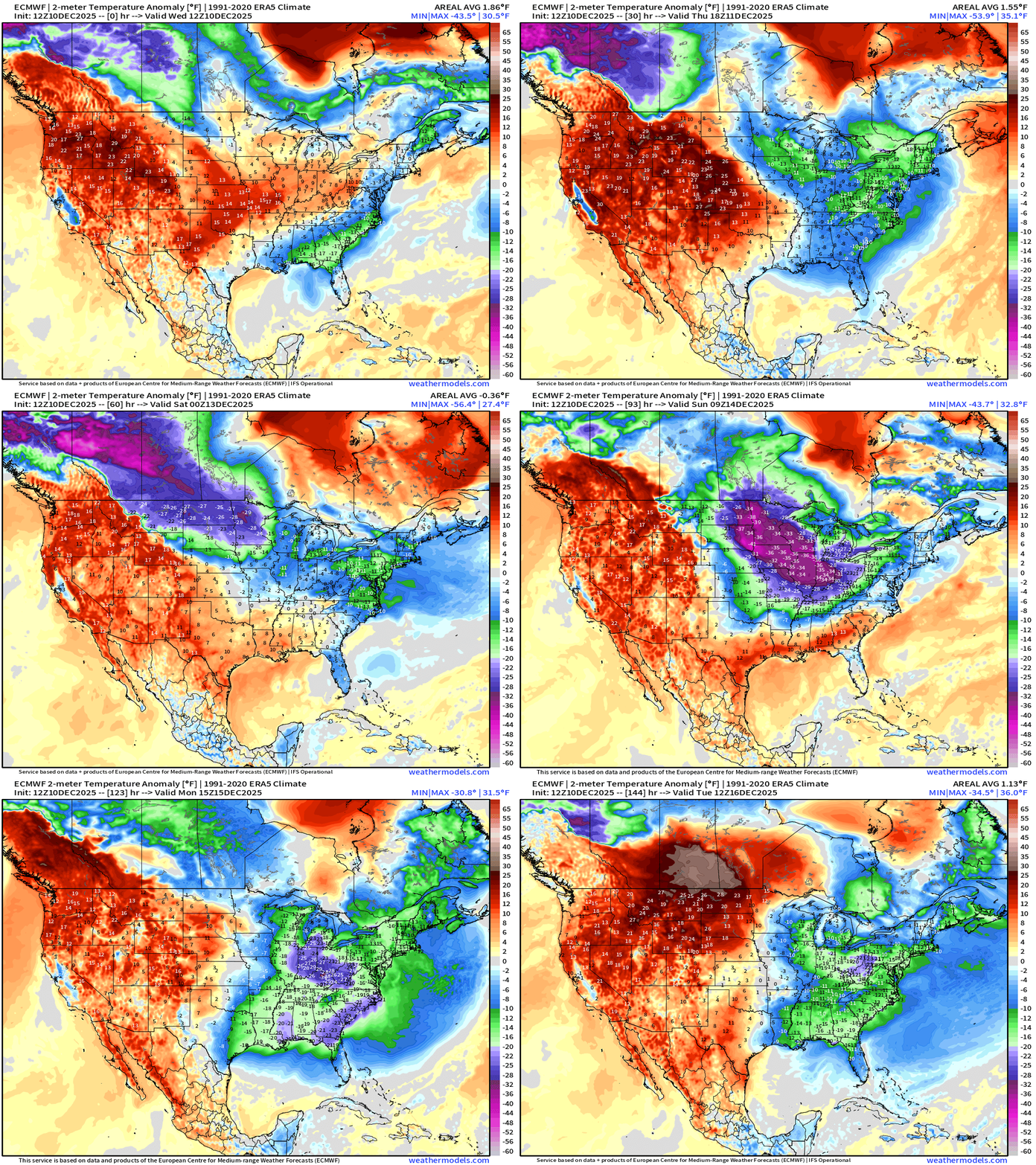
Exceptionally cold air spills into the Midwest and Great Lakes into this weekend, but warmer air from the Southwest and Gulf of Mexico battles back —> Light at the end of the tunnel
RTMA | Current Temperature Analysis | 5:45 PM ET
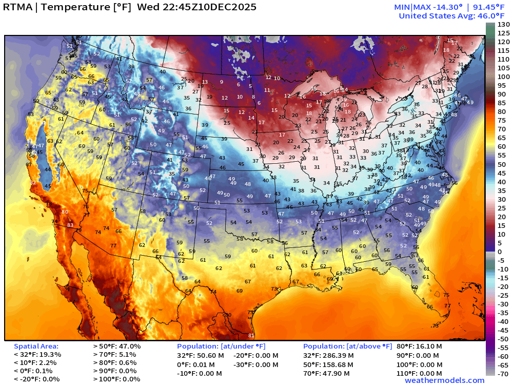
Average Lower 48 temperature was 46.0°F
Temperature Anomaly | 5:45 PM ET
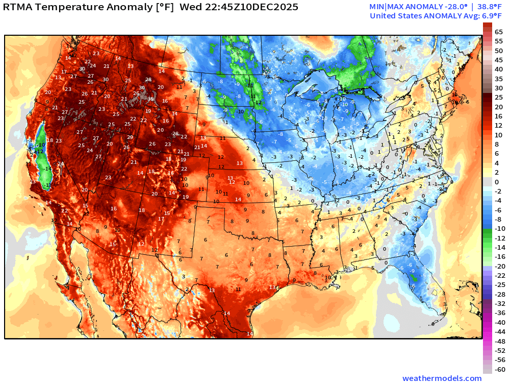
Lower 48 Temperature Anomaly was 6.9°F ABOVE normal
Thursday Morning Low Temperatures
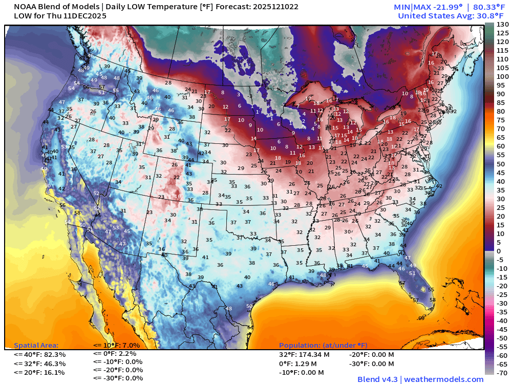
174 million below freezing (Lower 48 average low is 30.8°F)
Thursday High Temperatures
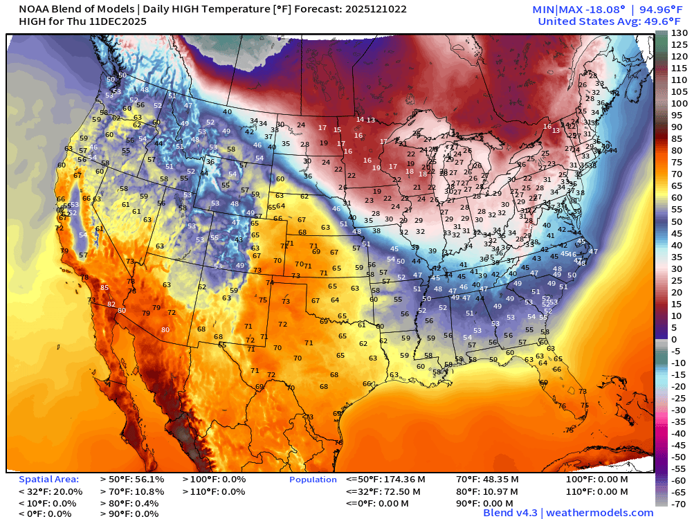
Warming trend continues as 56% of the Lower 48 by area > 50°F and we do have almost 50 million population at least 70°F
Sunday Low Temperatures | Arctic Blast Peak in Midwest + Great Lakes
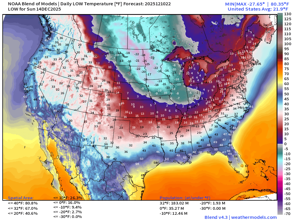
Frigid across the Midwest —> colder than -20°F over Iowa, Minnesota, and the Dakotas
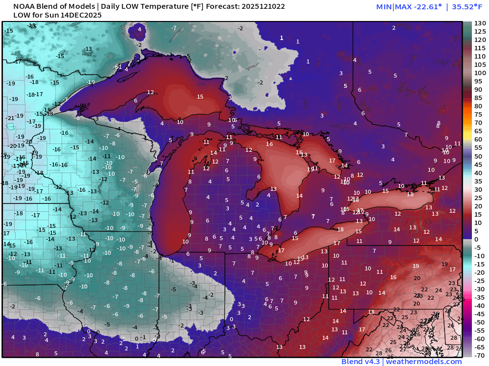
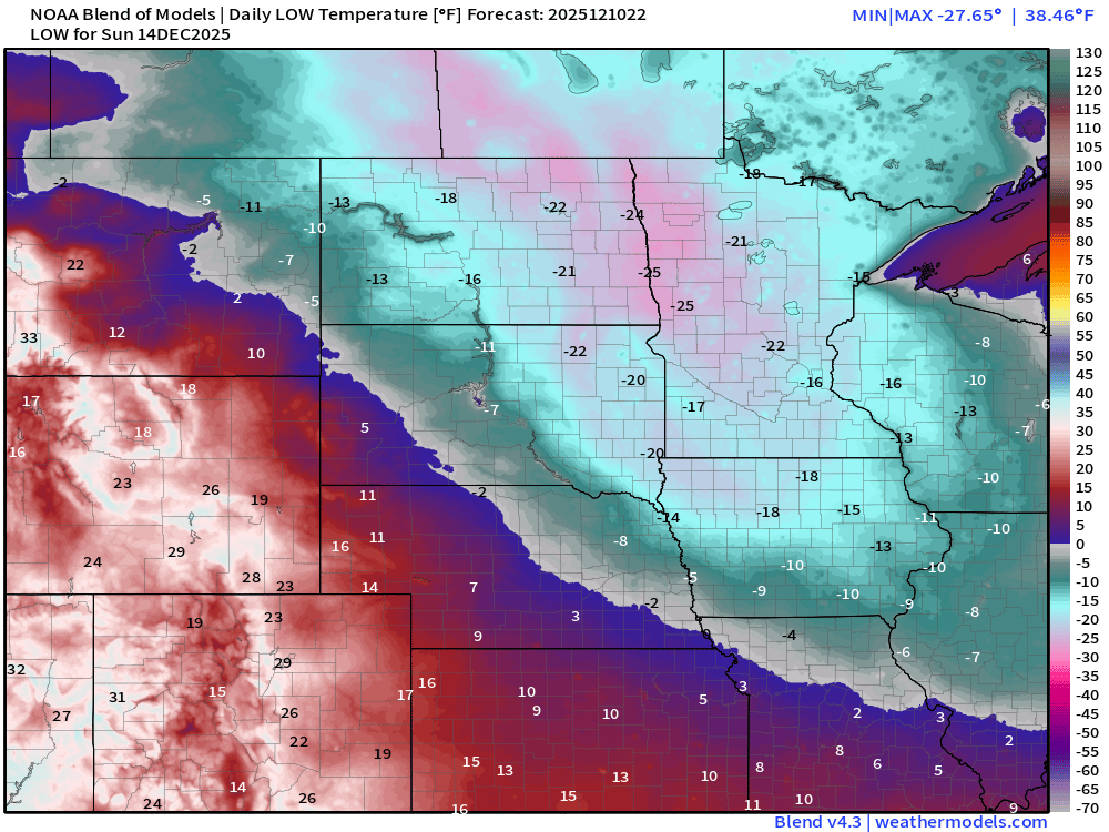
Chicago potential for two subzero mornings (Sunday -4°F and Monday 0°F)
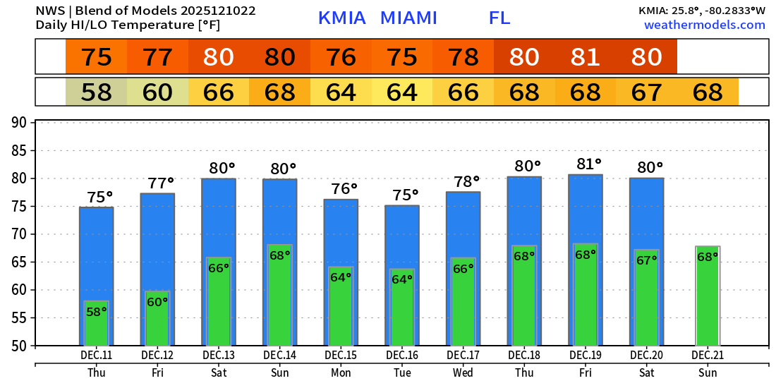
Upper 70s to lower 80s in Miami through next 10-days
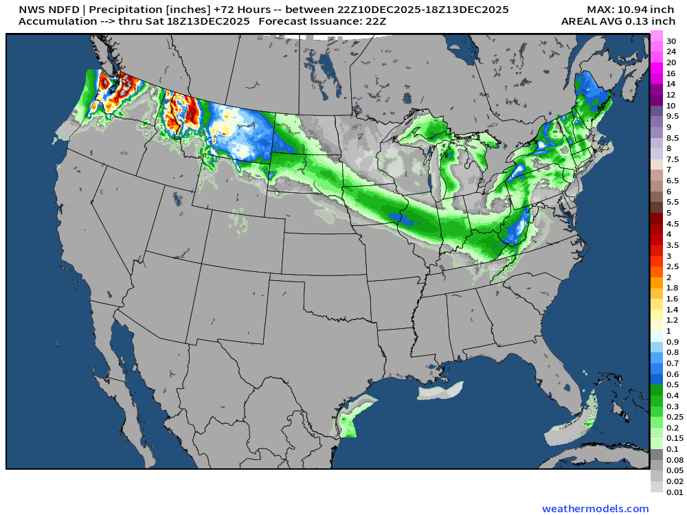
NWS Precipitation Next 72-hours
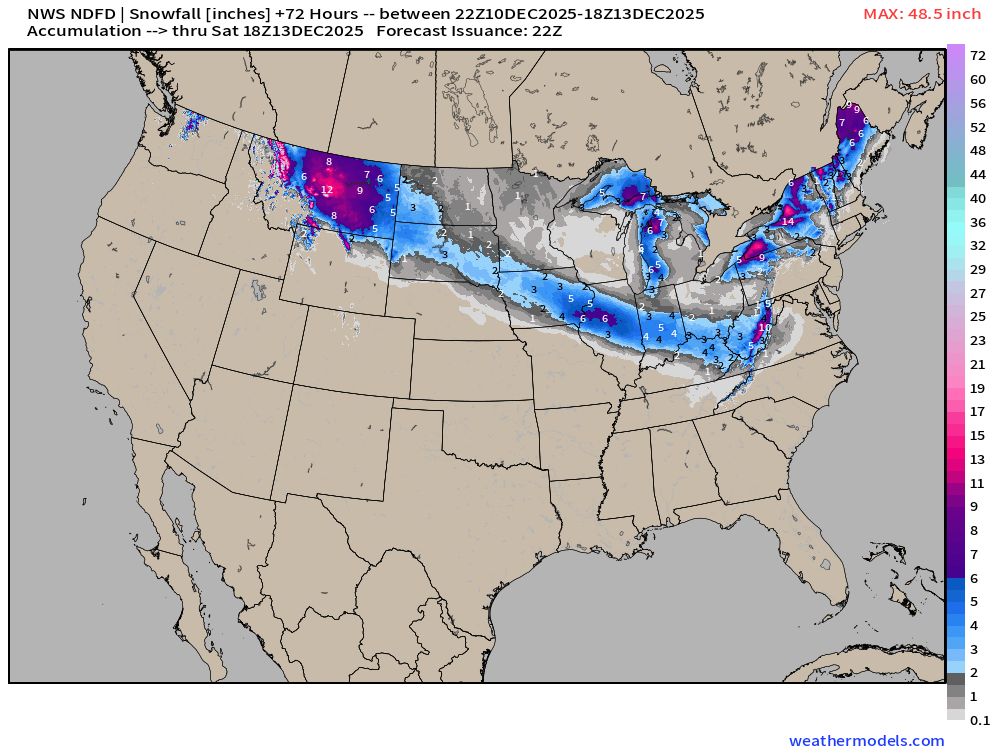
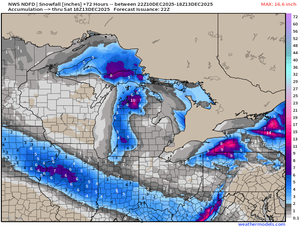
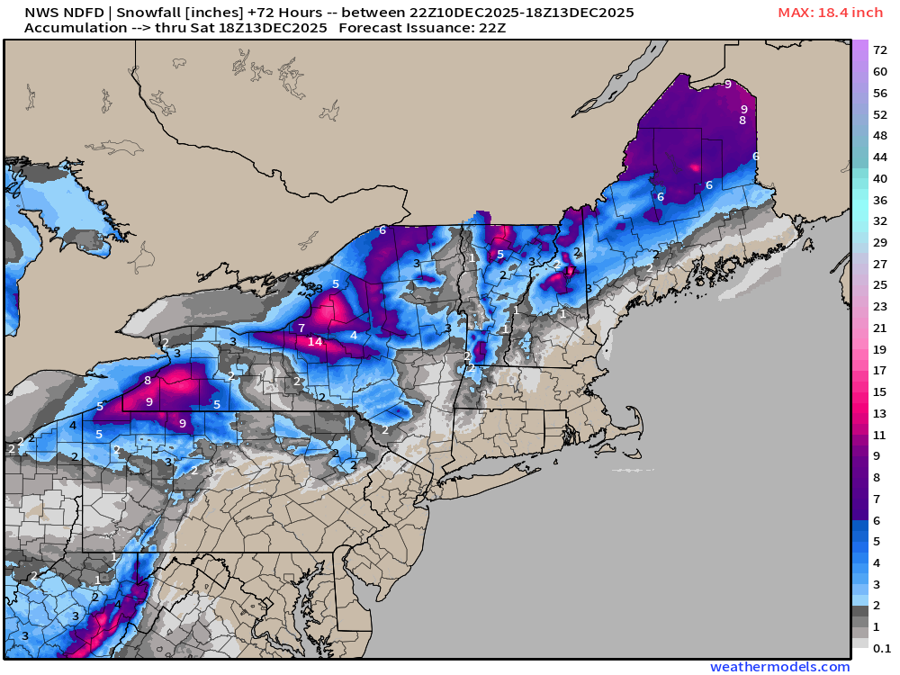
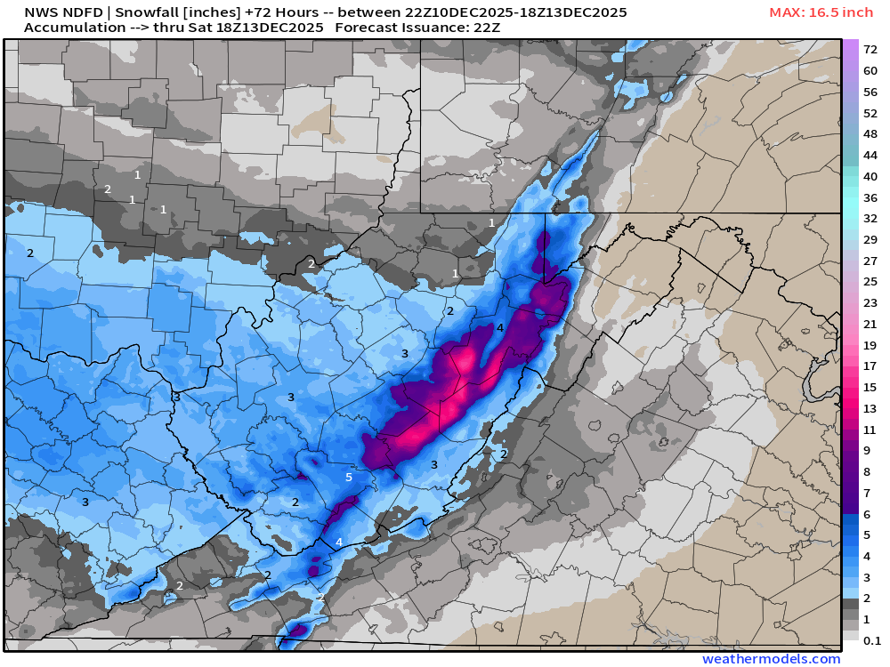
NWS Snowfall Next 72-hours
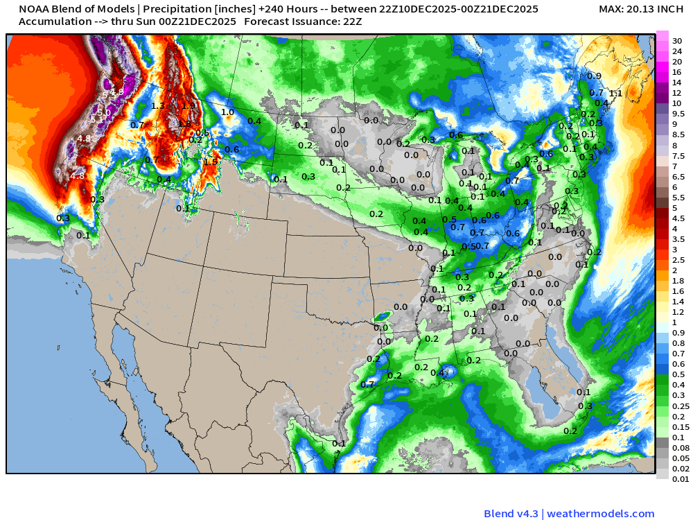
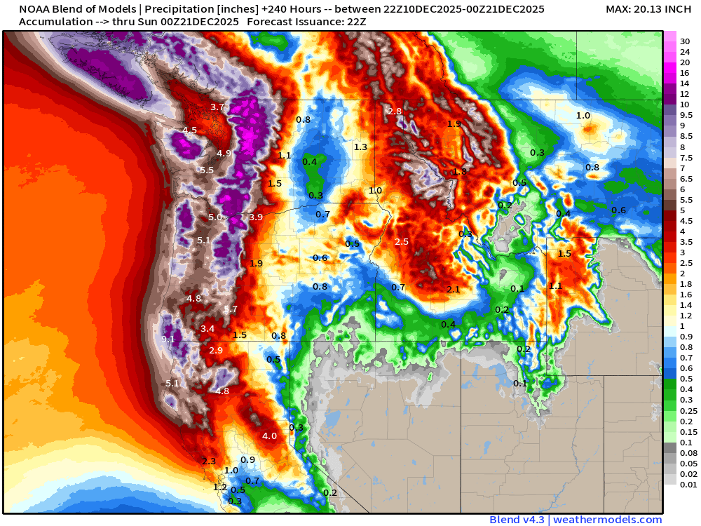
Blend of Models | 10 Days Precipitation Total
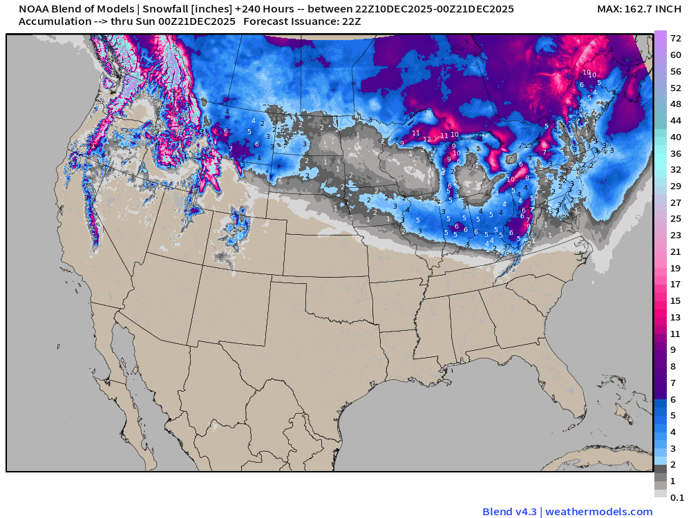
Blend of Models | Total Snowfall Next 10-Days
ECMWF AIFS-Single 12z | Height Anomaly (500 hPa) Next 10-days
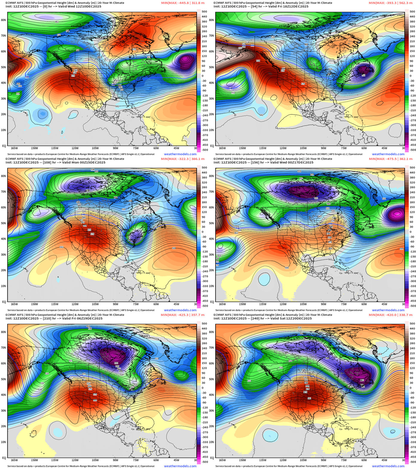
Even with the strong ridging across the Western U.S. the Northeast sees enough of a weakness to let “Polar Vortex” origin troughs to reach the Lower 48 — with cold air — so this “Blow Torch” pattern has the potential to be eroded at the margins —> but since that’s where so many people live in New England, surprise heating degree days could show up out of the blue (or the ensemble mean)
Day 10 —> see the potential for a Northeast major trough (!)
NOAA AI-GFS 18z | 500 mb Temperature | Next 10-days
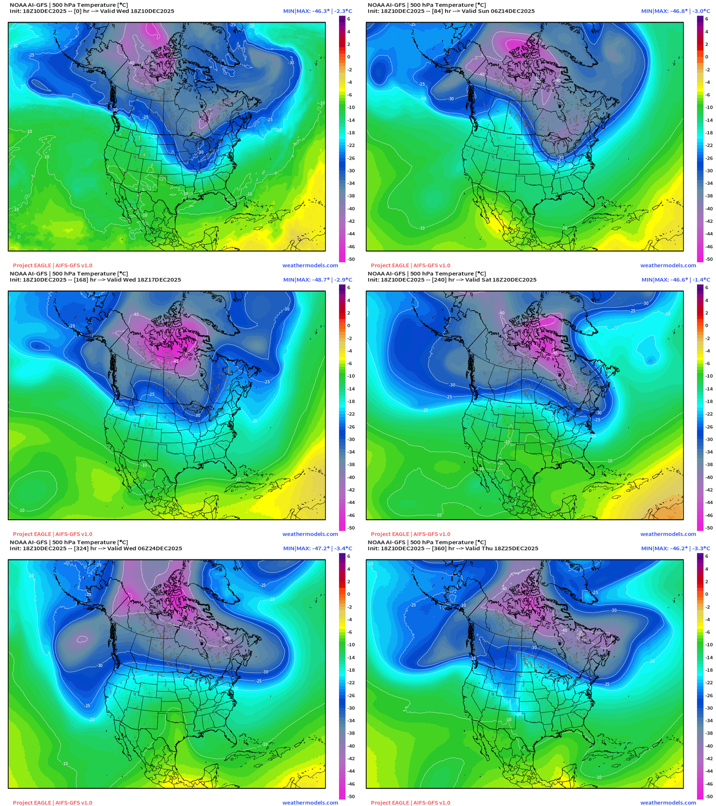
The main “polar vortex” centroid is anchored over Hudson Bay —> 50°C intensity at 500 mb
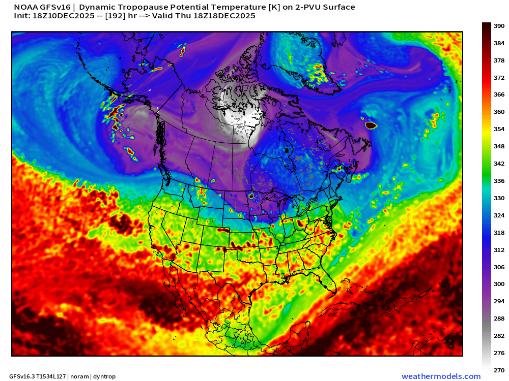
Dynamic Tropopause Day 8 Little White Fuzzball
Day 10 | 500 mb Height Anomaly from ECMWF AI/Full Physics Products
ECMWF 12z | Integrated Vapor Transport Next 10-days | North America
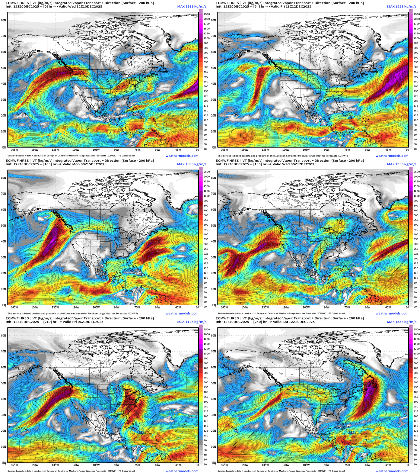
Parameter used for monitoring “atmospheric rivers” usually along the U.S. west coast, but the idea works well for many other areas — highlighting midlatitude storm systems with warm conveyor belts (moisture plumes)
ECMWF 18z | Snowfall | Next 6-days
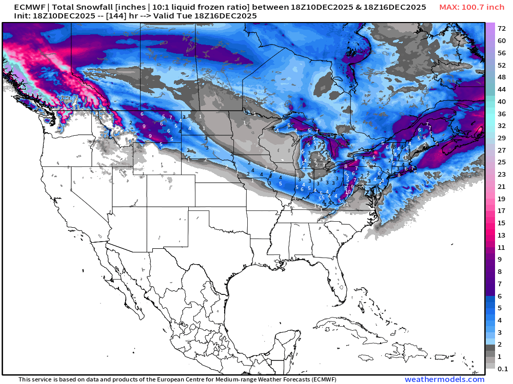
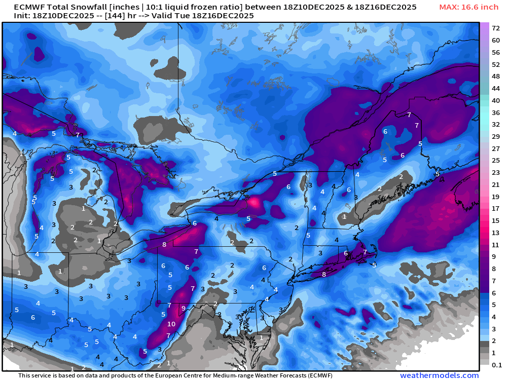
Watching with significant interest —> 4”-8” in NYC to Boston from sneaky coastal storm!
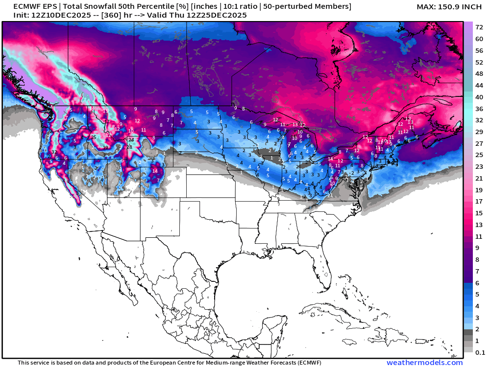
ECMWF EPS 12z | Ensemble Median Snowfall Next 15-days
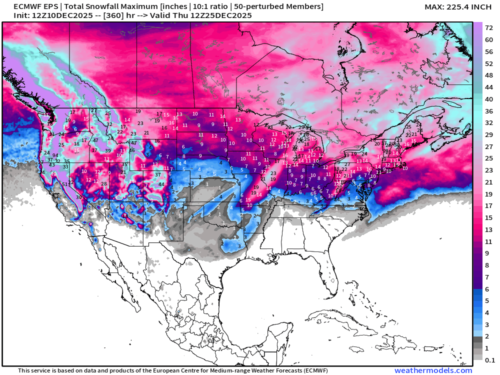
ECMWF EPS 12z | Ensemble Maximum Snowfall Next 15-days
Worst possible case for entire 51-member ensembles.
ECMWF EPS 12z | Ensemble Snowfall Probability > 1” | Next 15-days
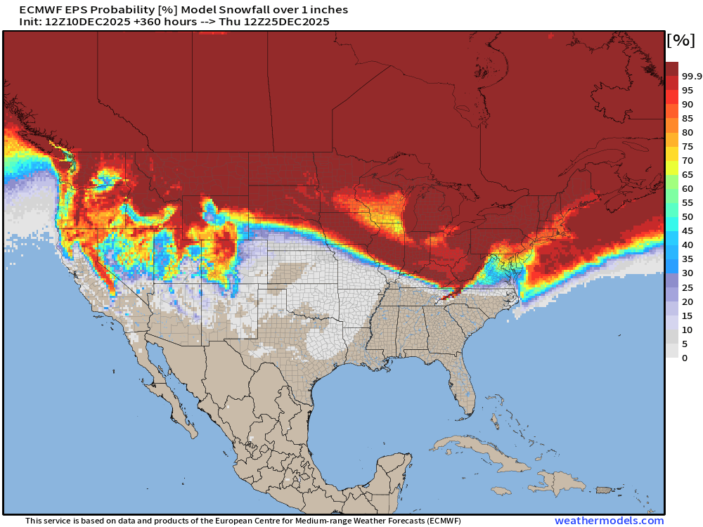
We’ll be monitoring the 1” chance of snowfall for a “White Christmas” in the coming weeks. This map is morning December 25th.
ECMWF EPS 12z | Ensemble Snowfall Probability > 6” | Next 15-days
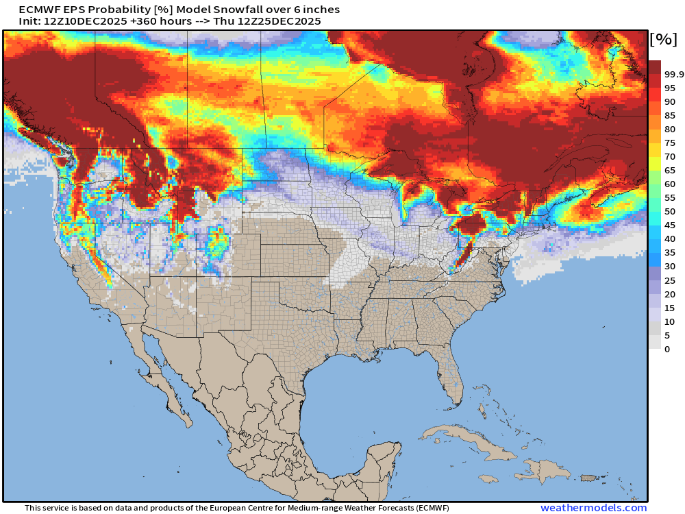
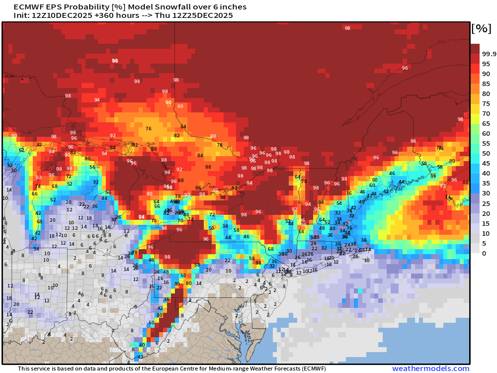
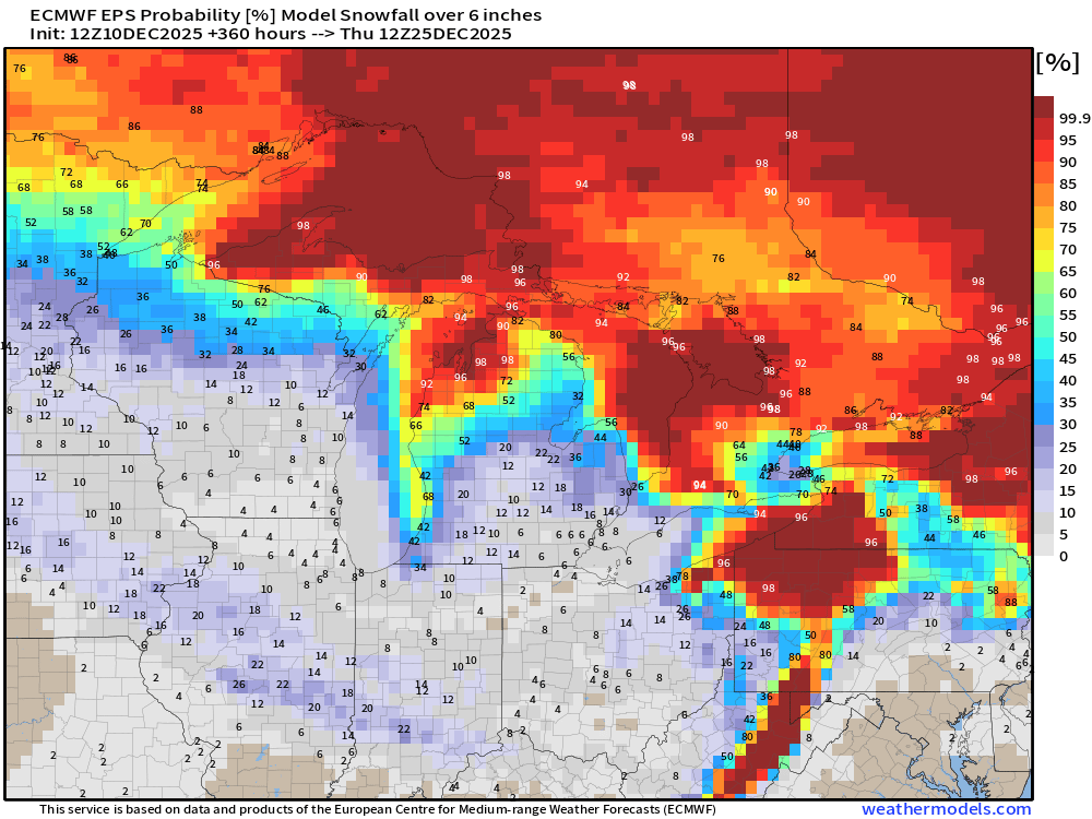
6-inches is sufficient for a “big storm” and Lake Effect machine diagnostic
Next 15-days Temperature Anomaly | Ensemble Mean to December 24
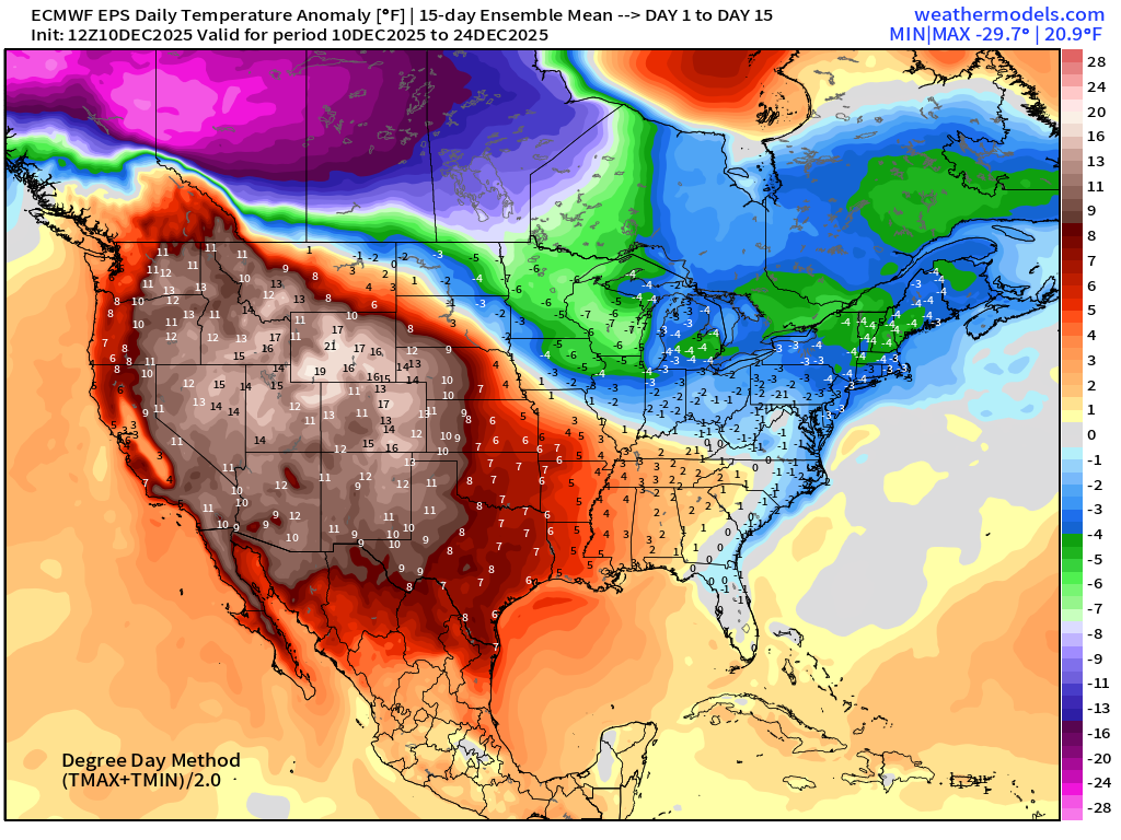
The western ridge is STRONG … and should provide enough Pacific moisture and moderating mild air to temper the longevity and intensity of any Arctic blasts that sink from the massive cold pool over Western Canada.
Temperature Anomaly | Next 15-days | ECMWF EPS 12z
5-Day Chunk #1 | Temperature Anomaly | Dec 10 - Dec 14
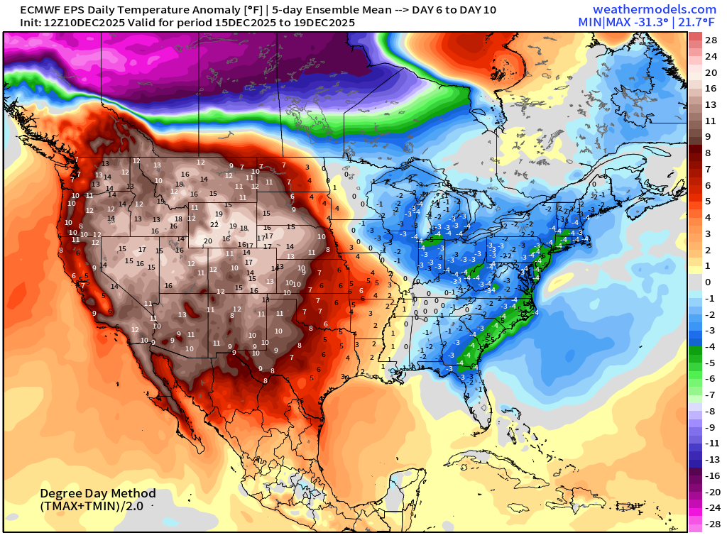
5-Day Chunk #2 | Temperature Anomaly | Dec 15 - Dec 19
5-Day Chunk #3 | Temperature Anomaly | Dec 20 - Dec 24
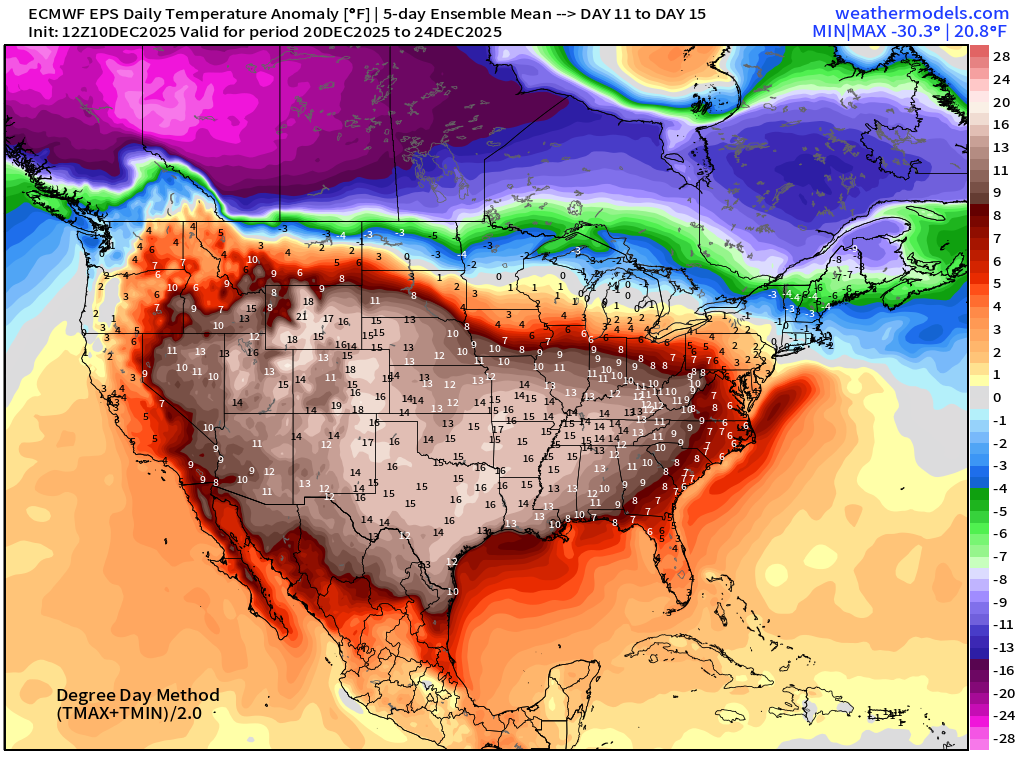
Way, way below normal cold-pool lurks in Western Canada and Alaska.
Comparison with 5-Day Chunk #3 from the 00z EPS cycle
5-day Difference between the previous cycle
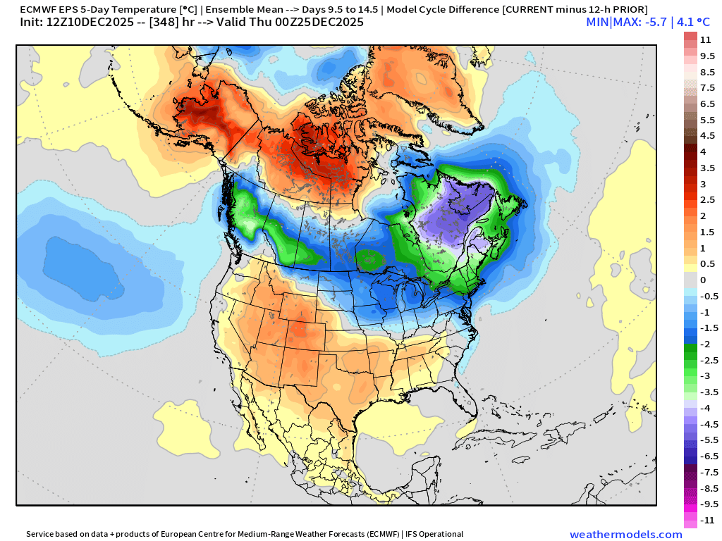
Note, we’ll be watching the Canadian border in the coming days.
Maps sourced from weathermodels.com designed and innovated by yours truly! Please subscribe there for real-time access to the newest maps, charts from all of the weather models including ECMWF and AIFS, NOAA AI-GFS/AI-GEFS
Active coupon codes:
- Milepost
- 812 · laid 2025-12-11T00:17:33.745000Z
- Source
- https://weather.substack.com/p/december-10-2025-wednesday-evening
- Digest
- d3be3e9f7b4c3828155738bc1dcb06535b289a4a5ca1fd66401b92cf91b09b3e
- Machine
- JSON