December 4, 2025 Thursday Evening Weather
Huge cold pool forms in western Canada and Alaska into mid-December
December 2025 was the 5th-warmest December in the 131-year national record (1895–2025), at 37.8°F against a 1991–2020 normal of 34.3°F (+3.5°F).
December 2025 was the 37th-driest December in the 131-year national record (1895–2025), at 2.0in against a 1991–2020 normal of 2.5in (-0.5in).
NOAA/NCEI Climate at a Glance, contiguous United States. This is the observed record for the month, not a score of anything said in this piece — the forecast ledger begins 2026-08-17 and cannot reach earlier posts.

Temperature Anomaly | Next 15-days
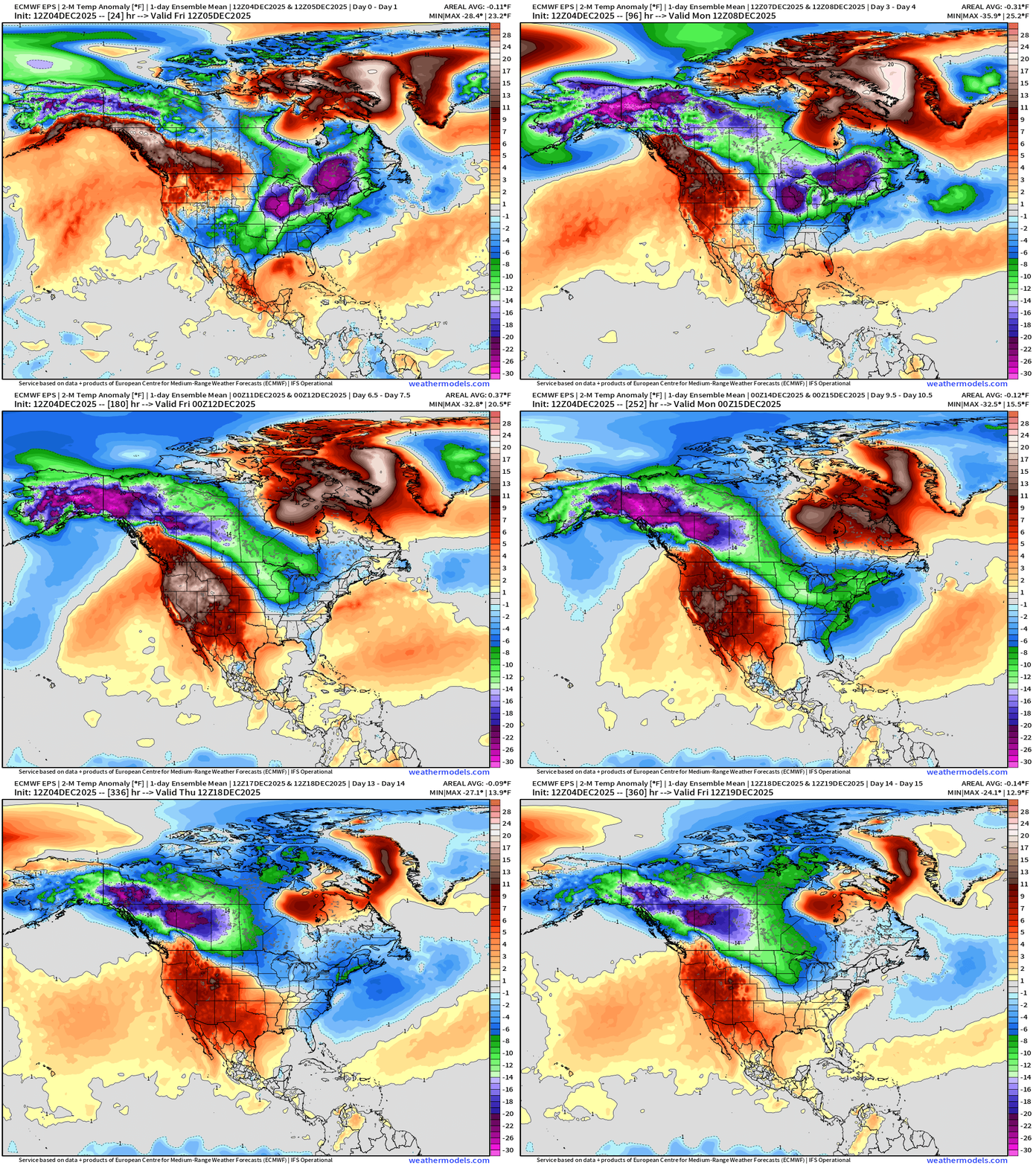
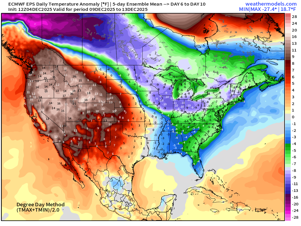
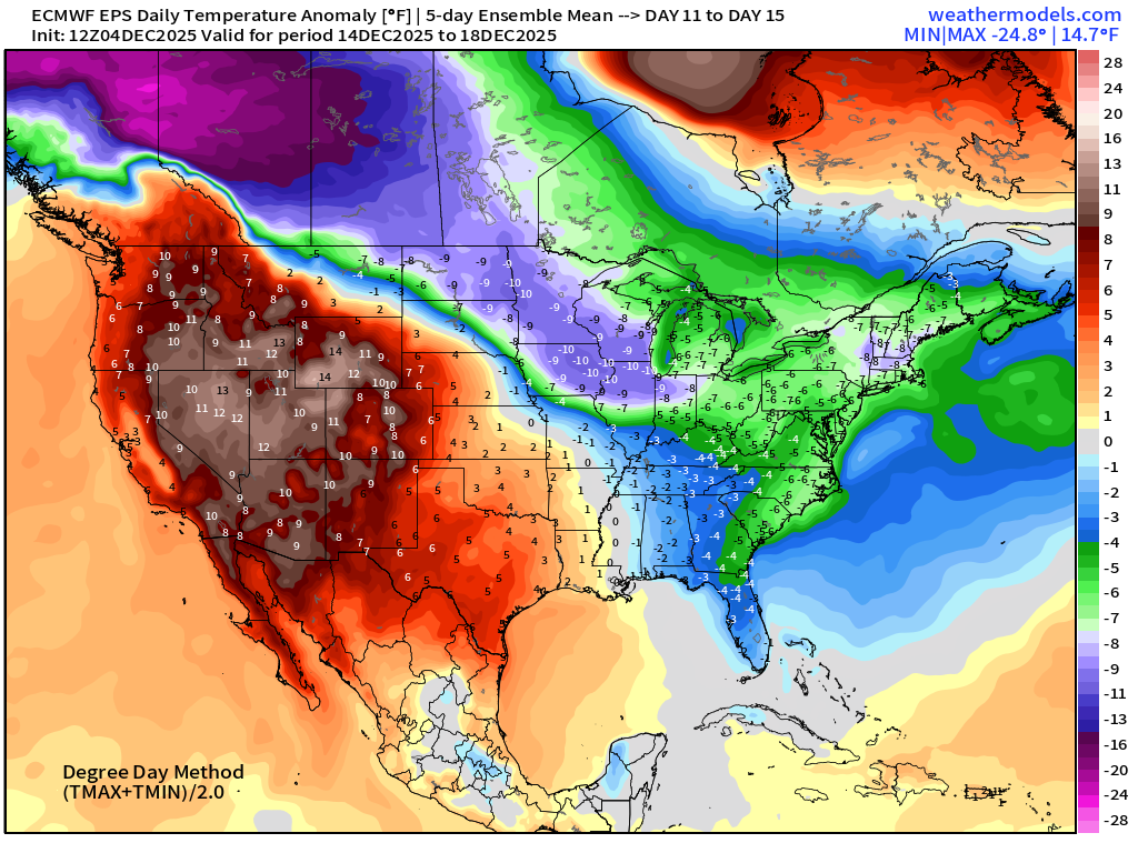
Flagship European model ensemble solution for temperature anomaly next 15-days shows the cold pool formation and intensification over Alaska and Western Canada — a more typical Polar Vortex dump with strong surface high pressure blasting southward along and east of the Rockies into the central U.S. in the 2-week time frame —> remnants of our recent/ongoing stratospheric warming event —> and then another one in the coming 10-12 days!
Note, there are fast moving disturbances or short-waves riding along the polar front from the Gulf of Alaska through the Pacific Northwest and then in the Midwest and Great Lakes. These features are spaced out in time — so the ensemble mean blends or smooths out 51 solutions that ALL have cold blasts but intermixed with warm periods. The end result is a rather smoothed continuous blob of cold connecting Alaska with the Northeast U.S.
This has potential for VERY cold Arctic blast outbreaks!
Weather into Friday morning | Fronts this evening
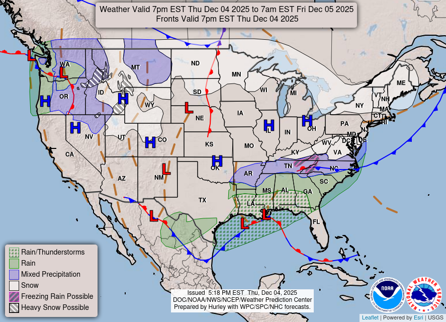
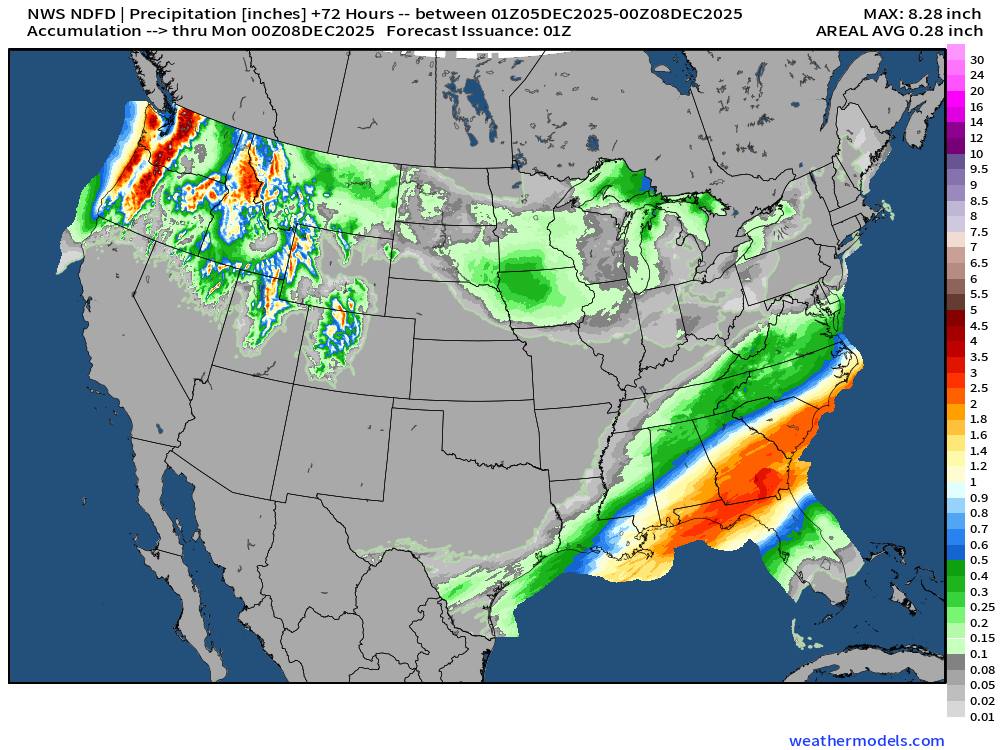
Southeast Storm System —> Heavy Rain for Gulf Coast + Mix/Snow into TN/VA this evening — as the moisture rides northward into much colder Arctic air — thankfully not a big ice or freezing rain ordeal
HRRR 23z | Next 18-Hours into Friday Noon
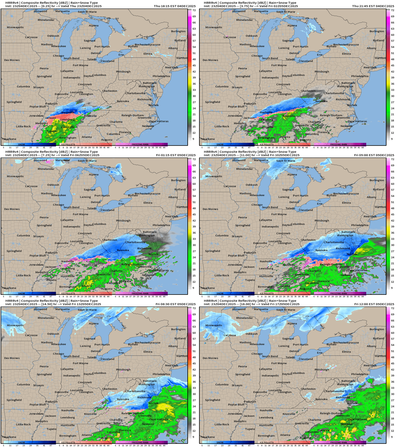
NWS has ticked up snowfall amounts in western VA into the more impactful range > 3” but still minor dusting or light snow in Washington D.C. for the 5th of December.
Precipitation Type | Weather Next 6-days | ECMWF 186z
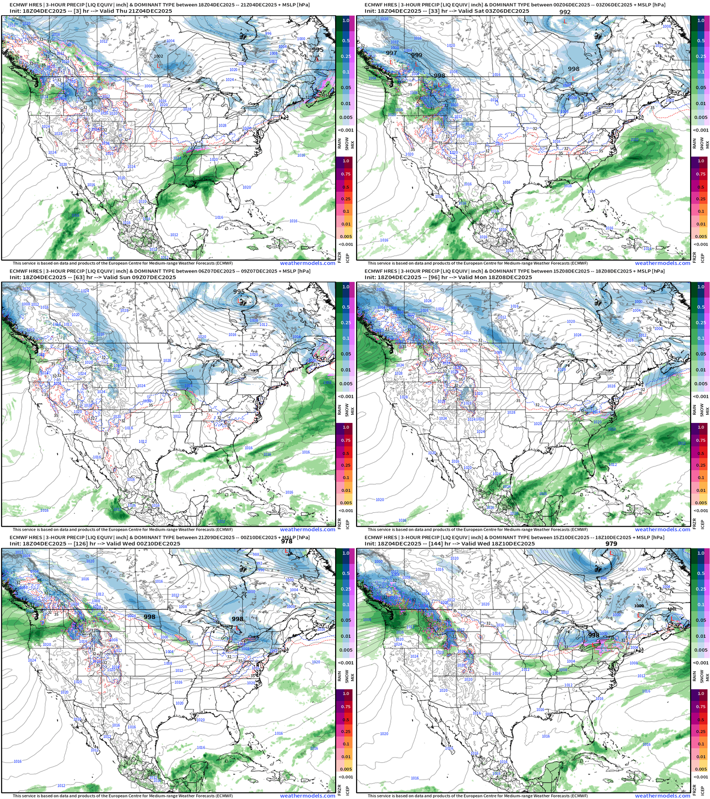
Boatloads of moisture coming into the Pacific Northwest with 2 major atmospheric river events in next 6-days … and Alberta Clippers pick up whatever makes it through the Rockies to take into the Midwest and Great Lakes with weak storm system snow events — eventually these start adding up!
Headlines Thursday Evening
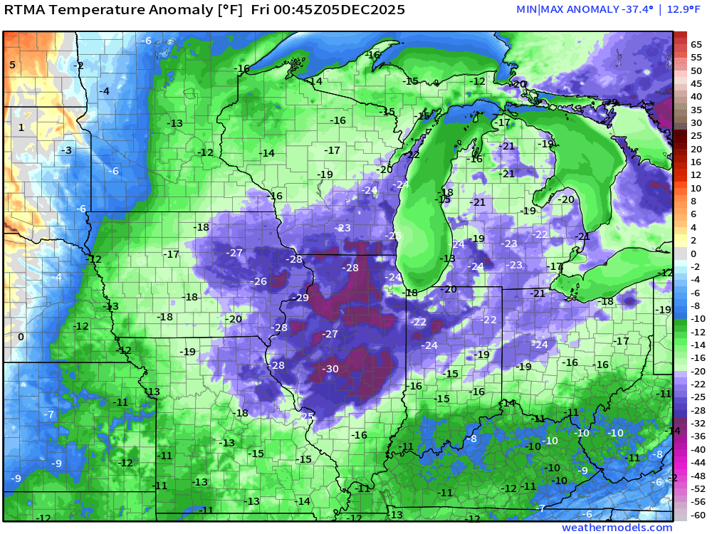
Very cold evening across the Midwest and Great Lakes —> bottom dropping out with temperatures from clear skies, calm winds, and snow cover
Still not seeing any strong systems across the Eastern U.S. but quick moving “cutter” or Clipper Systems could provide wintry precipitation especially with the cold air in place —> typical with negative AO/negative NAO
Major atmospheric rivers into the Pacific Northwest will be impactful — on the front end of a surge of Pacific / West Coast warmth that will try very hard to nose across the Rockies — and bust into the Arctic air mass. Ridging into Week 2 across the central U.S. would be a welcome reprieve from the Arctic air mass, but I’m less certain about the cold breaking in a sustained manner. There’s a HUGE load of cold air that will form over Alaska/Western Canada and be ready to dump southward into mid-December.
ECMWF 18z Precipitable Water Next 6-days | My favorite parameter
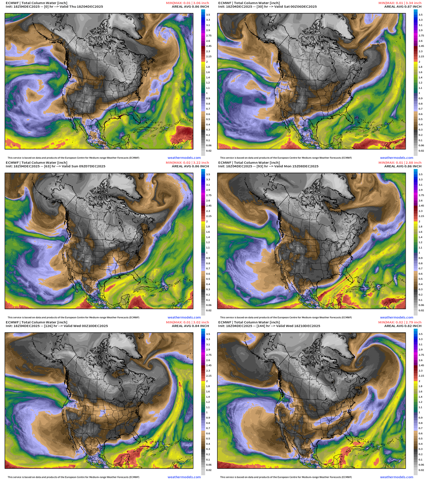
Atmospheric river systems into the Pacific Northwest — narrow at first, and then quite a wide swath by next Tues/Wed — see how shortwave disturbances along the polar front (polar vortex edge) pick up the moisture = Alberta clipper systems
White colored precipitable water = absence of moisture = cold/polar air mass
Temperature Analysis | 7:45 PM ET
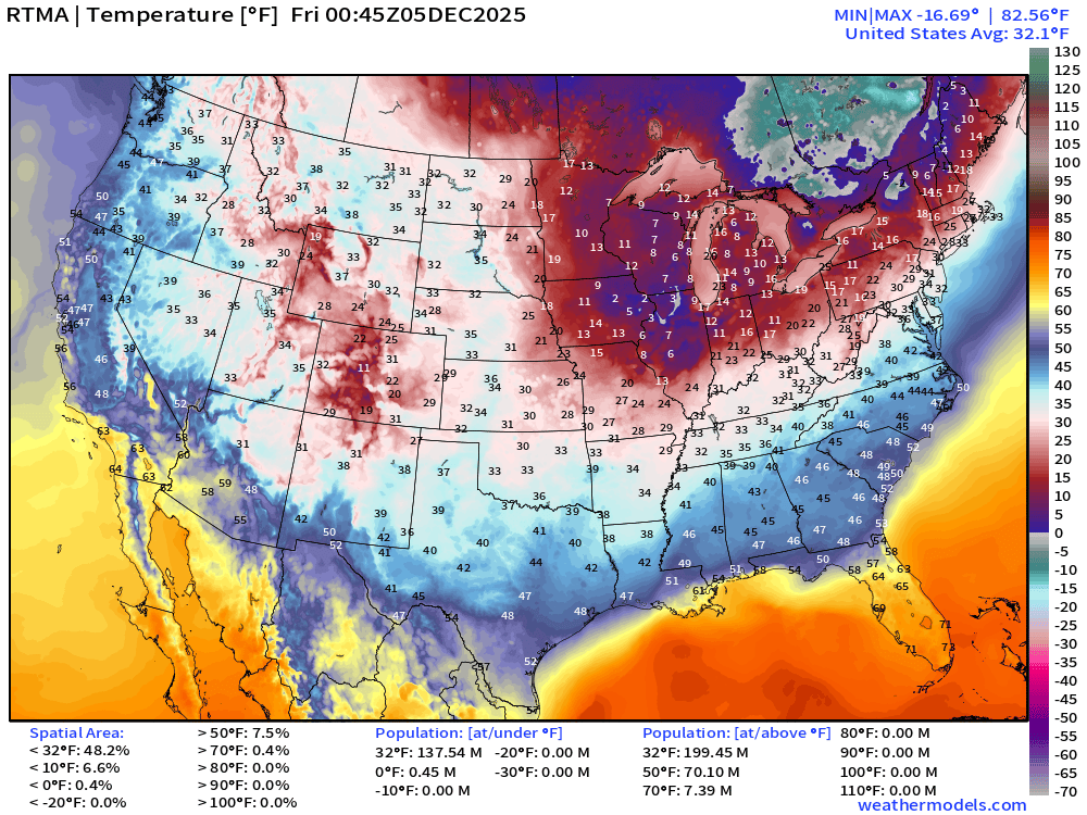
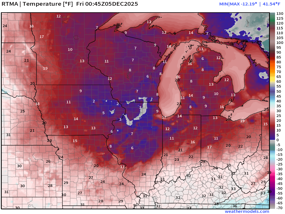
Temperatures crashing across eastern Iowa, northern Illinois, and southern Wisconsin
Temperature Anomaly | 7:45 PM ET
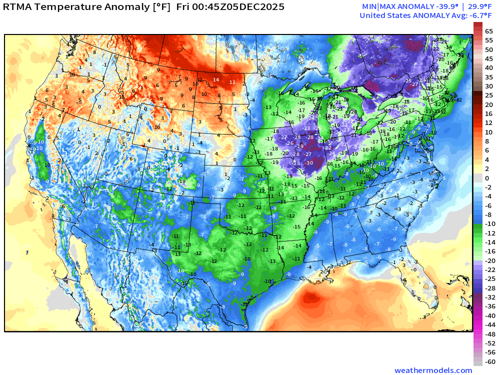
Lower 48 Temperature Anomaly was -6.7°F below normal
NWS Precipitation Next 72-hours
NWS Snowfall Next 72-hours
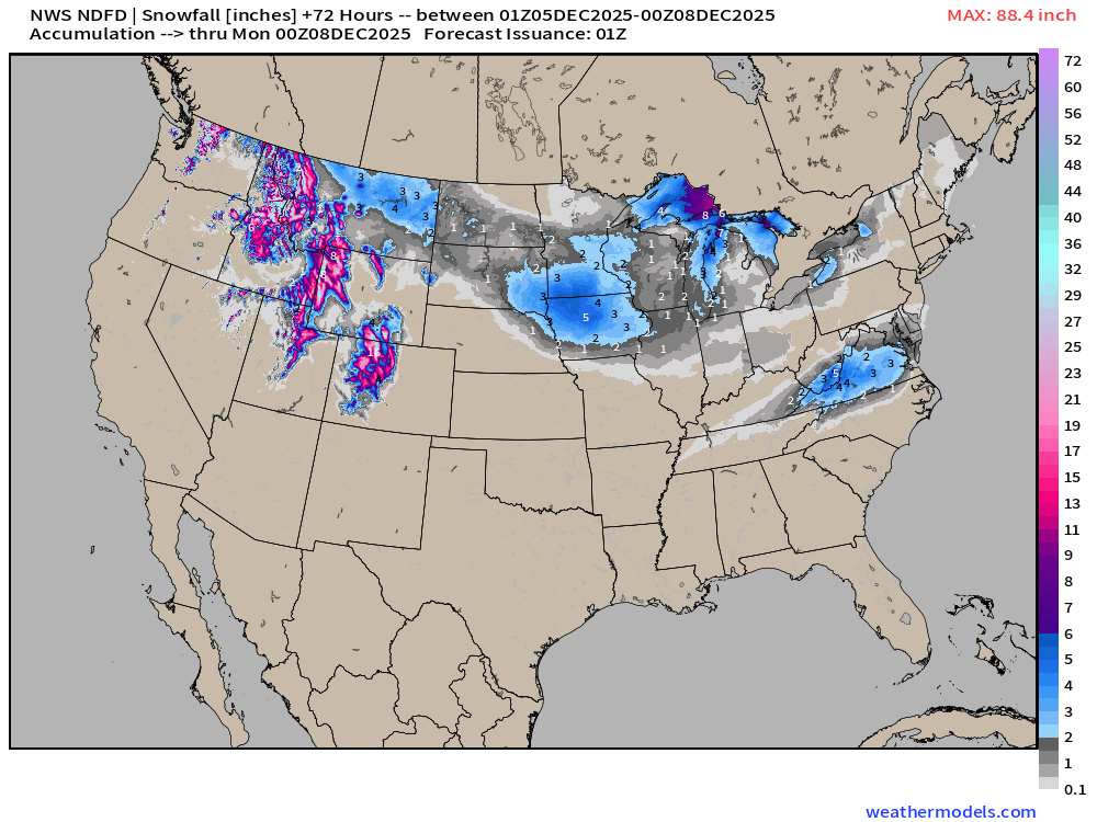
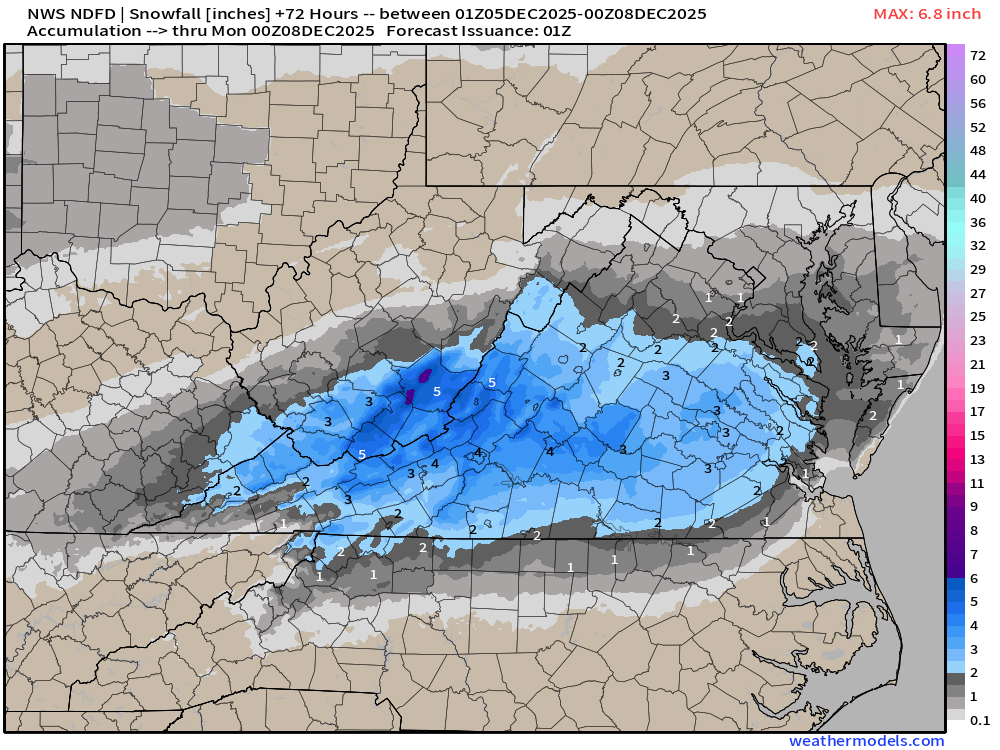
Just light dusting for Washington D.C. maybe 0.5” at most of light snow — but more across Virginia, painting within the lines of the state border!
Blend of Models | 10 Days Precipitation Total (includes liq from snow)
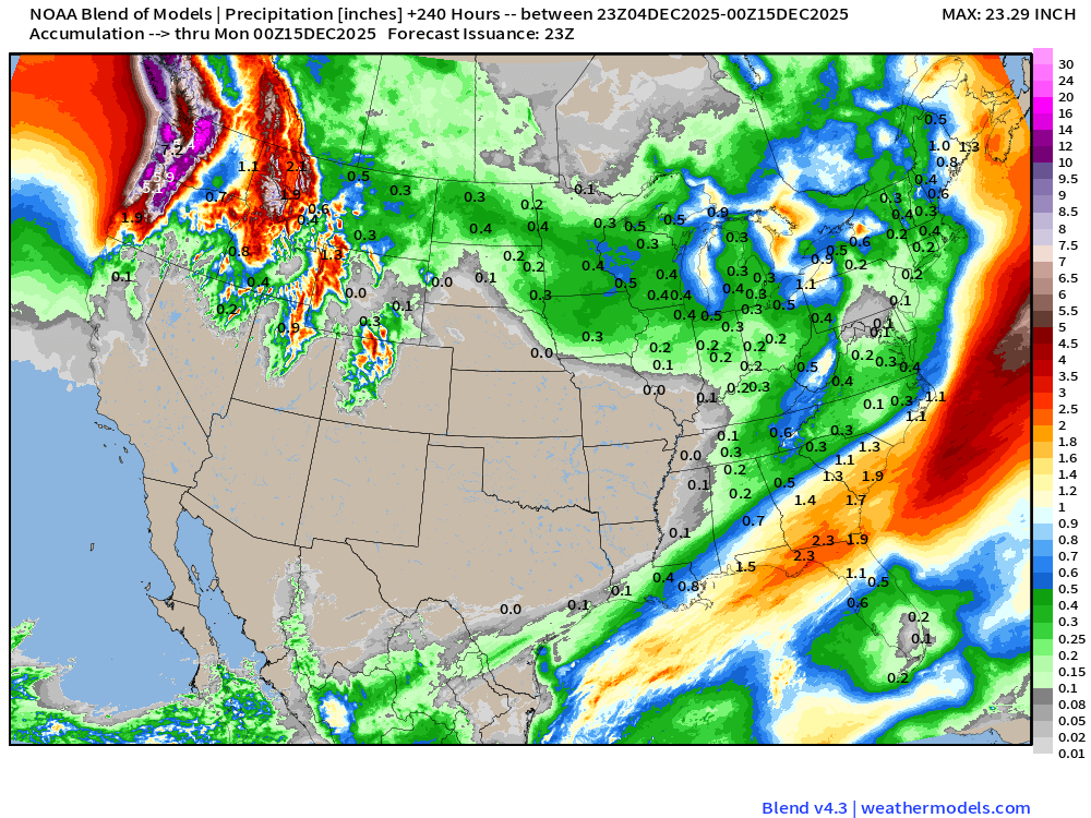
Enormous precipitation totals in the Cascades … upwards of 20” of QPF or more would translate into outrageous snowfall totals
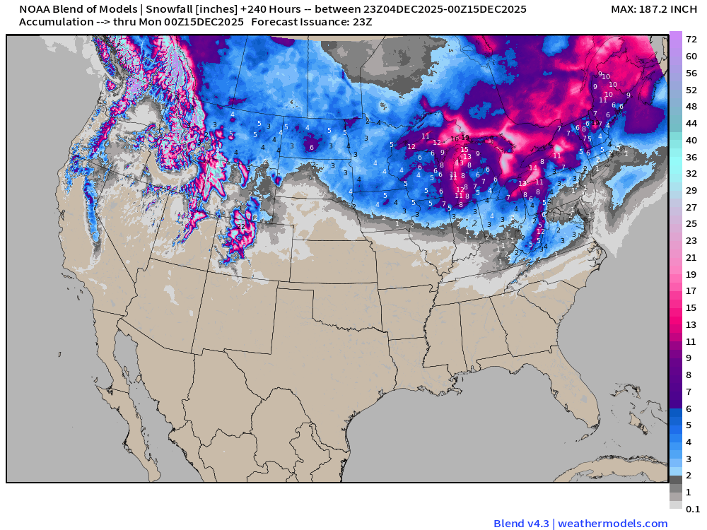
Blend of Models | Total Snowfall Next 10-Days
Friday Morning Low Temperatures
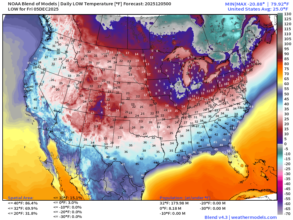
180 million below freezing (Lower 48 average low is 25.0°F)
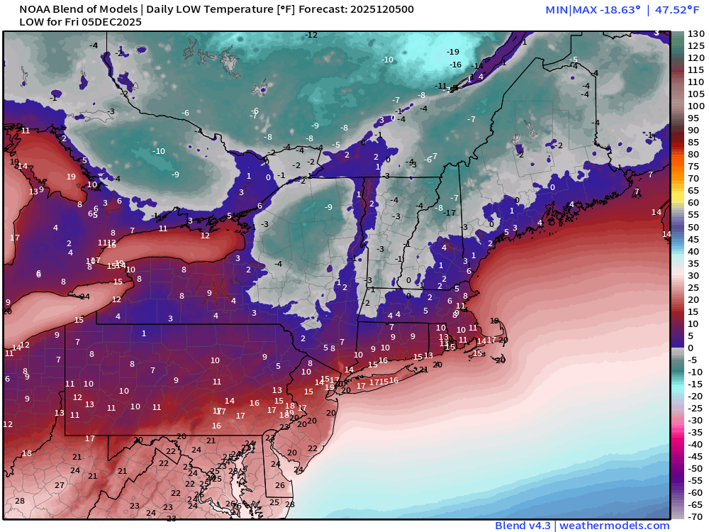
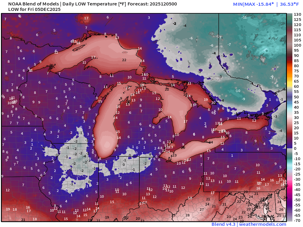
Friday High Temperatures
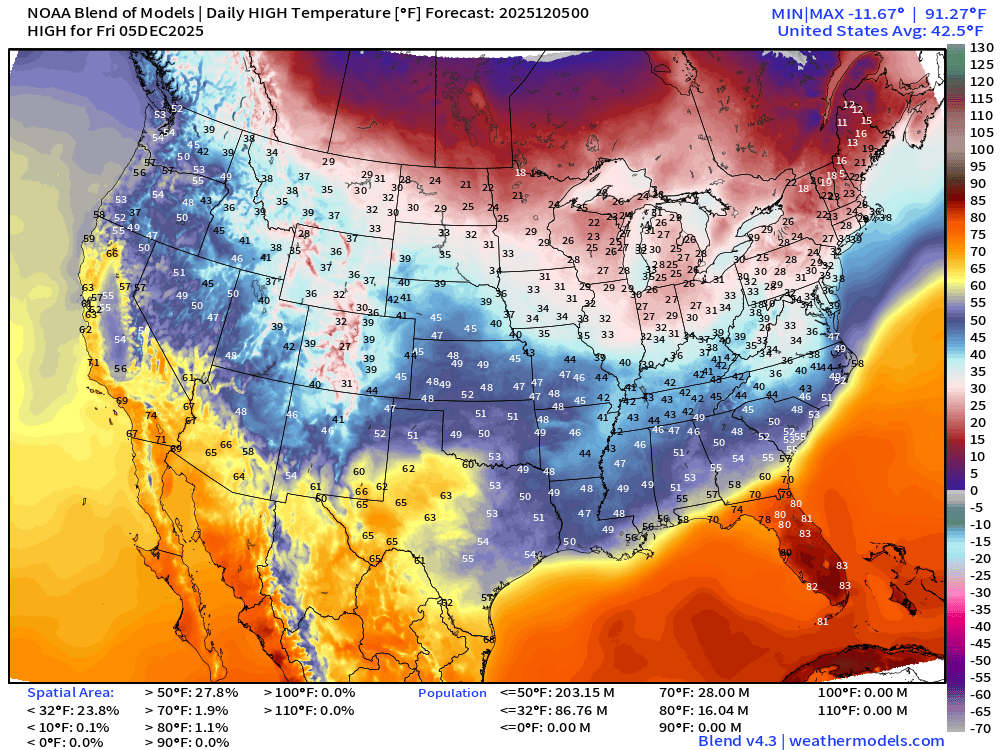
Still 16 million at/above 80°F in Florida! 87 million don’t get above freezing!
AI-GFS 18z | 500 mb Temperatures | Polar Vortex Watch Next 10-days

Fancy new tool from NOAA (AI-GFS) shows the reorientation of the tropospheric polar vortex to ditch the cold pool over Hudson Bay — and instead dip/focus across Western Canada
NOAA GFS 18z | Dynamic Tropopause | Next 10-days
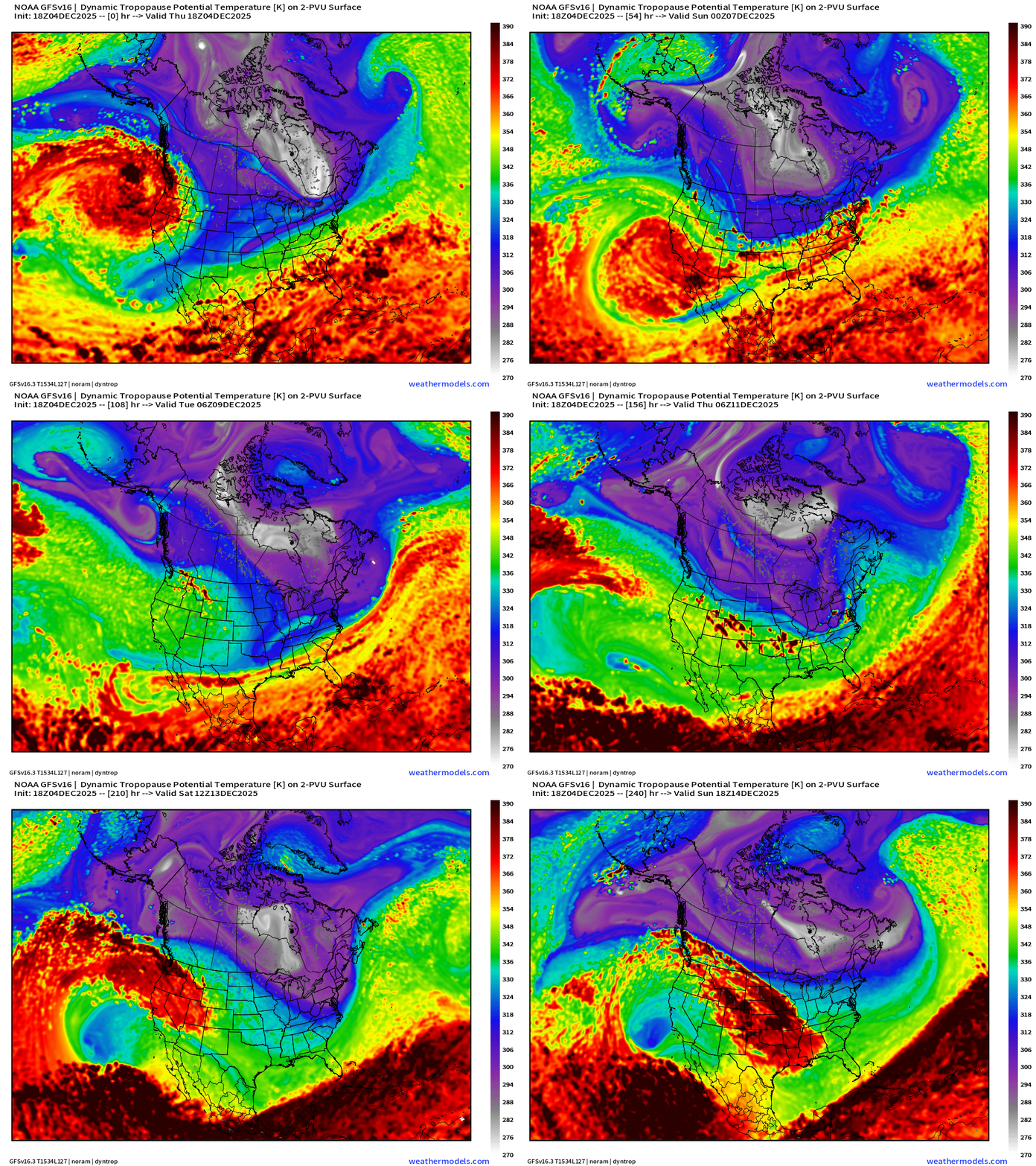
I haven’t shown the GFS in a while — just want to highlight the location of tropospheric polar vortex (big white fuzzball) swirling over Hudson and James Bay — not moving from its anchor position very much in 10-days.
ECMWF AIFS-Single 18z | Height Anomaly (500 hPa) Next 10-days
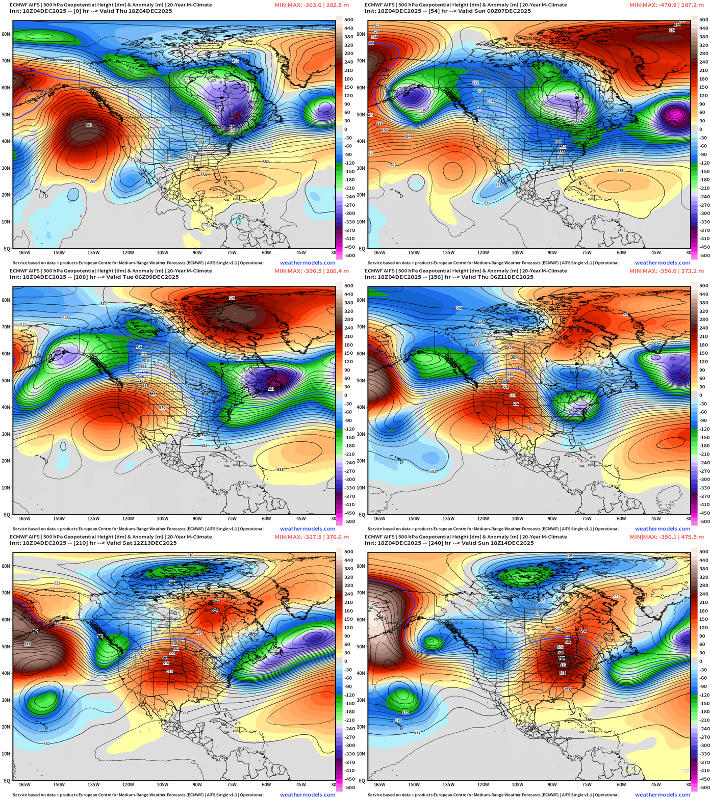
Strong trough = coldest air across the Midwest and Great Lakes at Day 7 —> but we have relief in sight with a building central U.S. ridge
Let’s hope this sticks around for as long as possible — and the Western Canada PV doesn’t arrive ahead of schedule (2-weeks)
Integrated Vapor Transport Next 10-days | North America
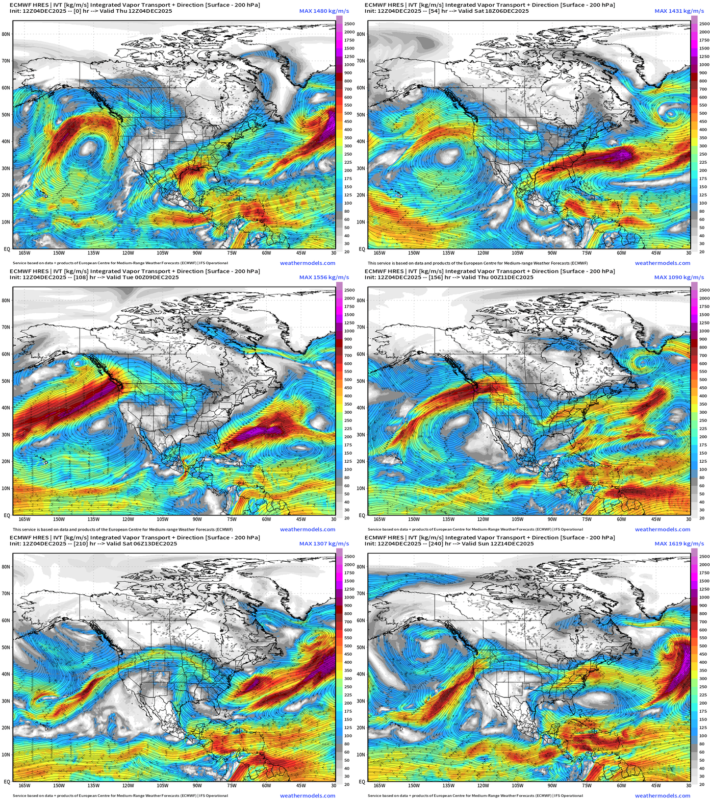
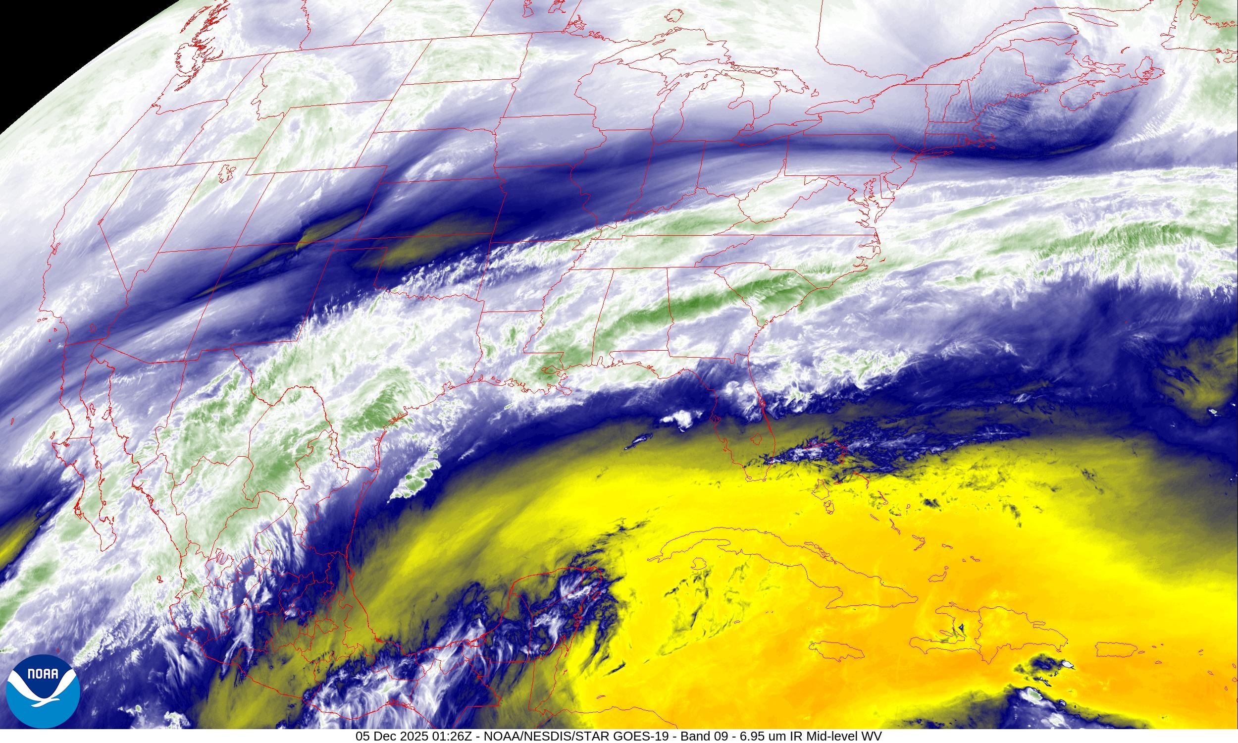
Parameter used for monitoring “atmospheric rivers” usually along the U.S. west coast, but the idea works well for many other areas — highlighting midlatitude storm systems with warm conveyor belts (moisture plumes)
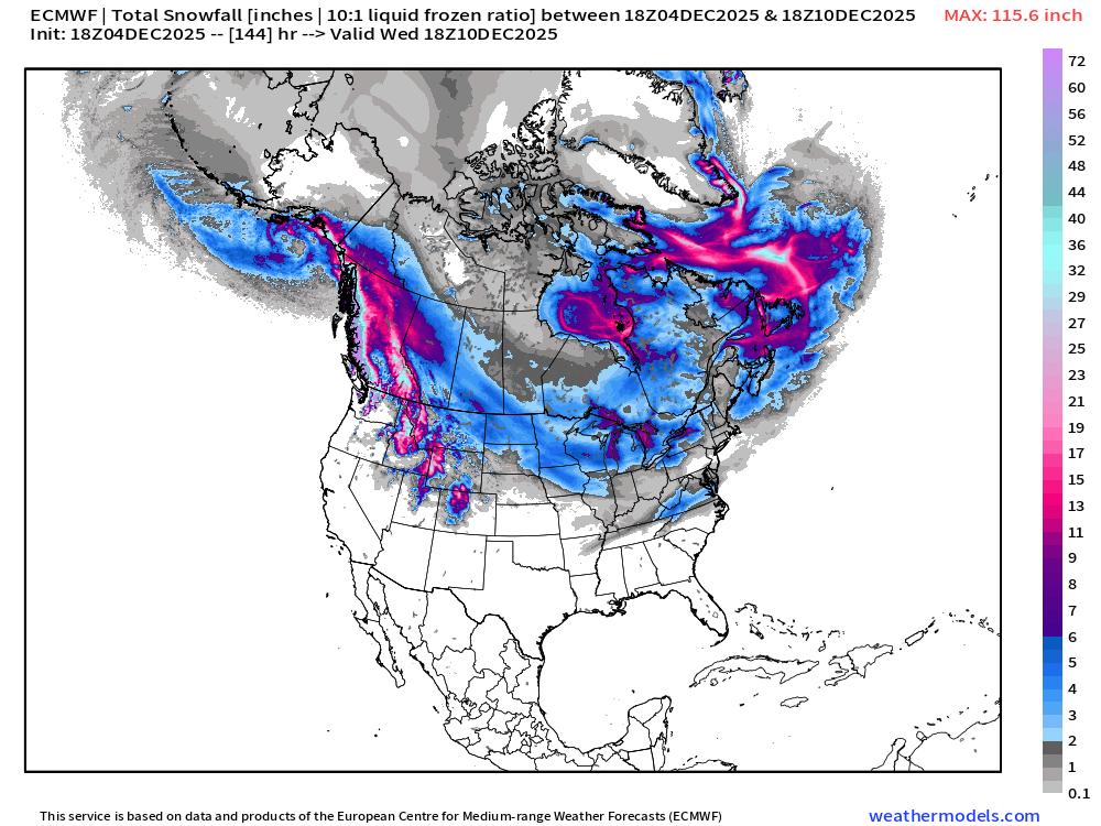
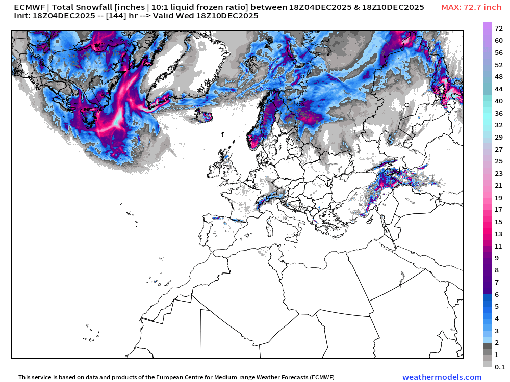
ECMWF 18z | Snowfall | Next 6-days
ECMWF EPS 12z | Ensemble Median Snowfall Next 10-days
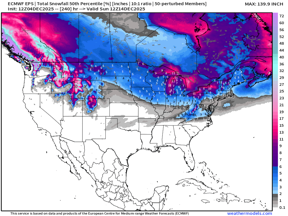
Instead of just the median — let’s look at the 90th Percentile — if the model ensemble was operating in the 1 in 10 worst snowfall category … most places it’s not a major difference BUT it can be —> ECMWF EPS 12z | Ensemble 90th Percentile Snowfall Next 15-days
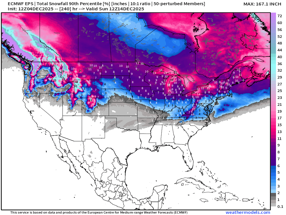
The difference between the 75th and 25th Percentiles is the interquartile range (IQ) and shows the ensemble spread to a good approximation! Even when we show the median snowfall amounts, there is a +/- range of sometimes a similar magnitude of the median/mean … and that’s why ensemble means of precipitation into the medium range can be misleading during storm events where 100 miles makes the difference between yes/no snowfall/rain — the average is not really a solution
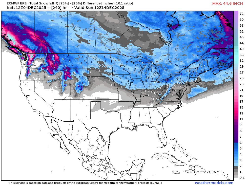
ECMWF EPS 12z | Ensemble Snowfall Probability > 1” | Next 15-days
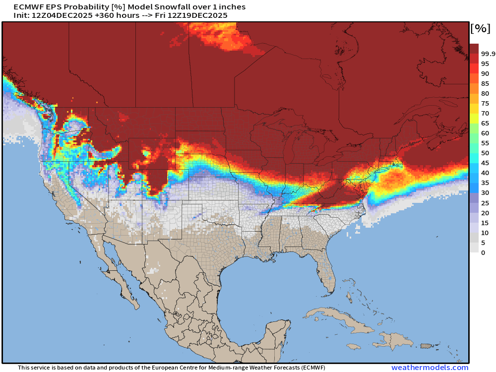
We’ll be monitoring the 1” chance of snowfall for a “White Christmas” in the coming weeks. This map is through late December 18th.
ECMWF EPS 12z | Ensemble Snowfall Probability > 6” | Next 15-days
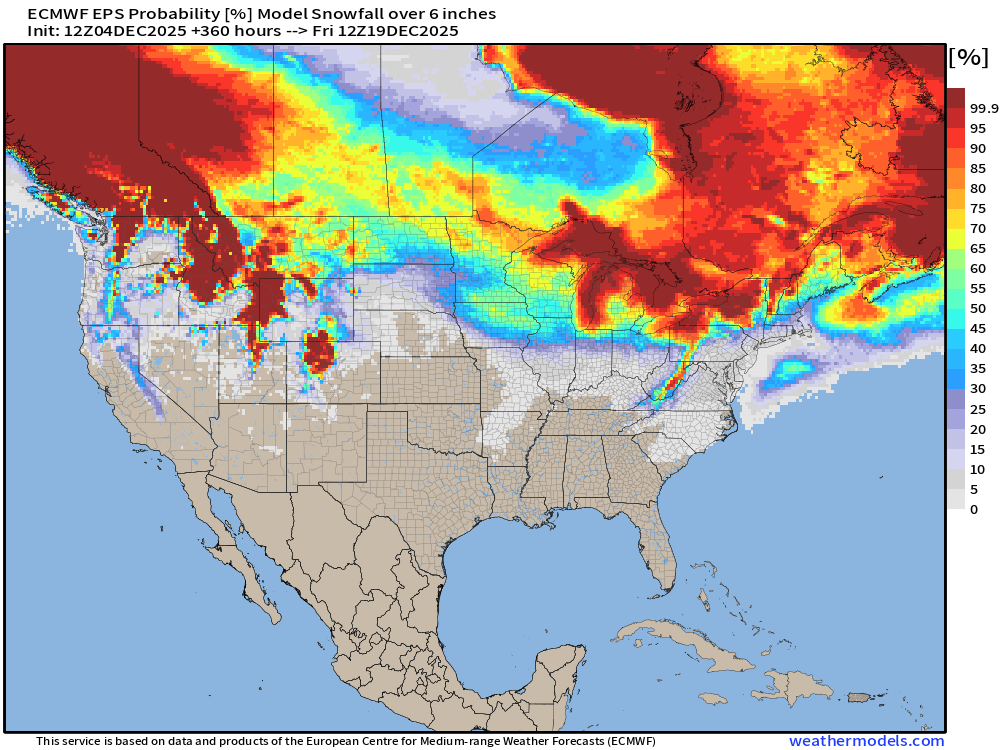
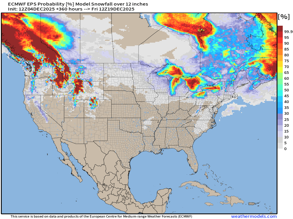
6-inches is sufficient for a “big storm” and Lake Effect machine diagnostic but 12” is even better —>
ECMWF EPS 12z | Ensemble Snowfall Probability > 12” | Next 15-days
Next 15-days Temperature Anomaly | Ensemble Mean to December 18
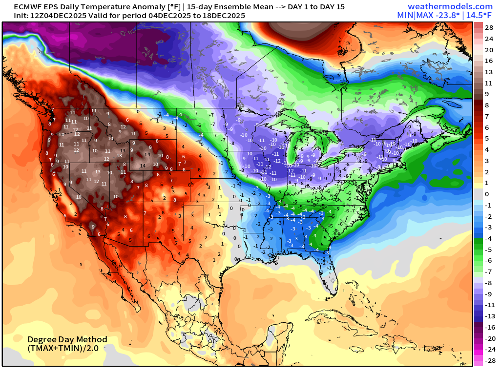
Main story for the week is cold air entrenched in the Midwest, Great Lakes, and Northeast with the main tropospheric polar vortex perilously close to the Lower 48 locked onto a fulcrum over Hudson and James Bay. However, ridging across the Western U.S. will push eastward and displace the Arctic air — hopefully, as a new cold pool forms over Western Canada
Temperature Anomaly | Next 15-days | ECMWF EPS 12z
5-Day Chunk #1 | Temperature Anomaly | Dec 4 - Dec 8
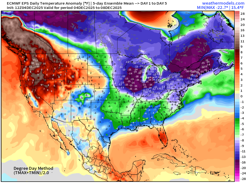
5-Day Chunk #2 | Temperature Anomaly | Dec 9 - Dec 13
5-Day Chunk #3 | Temperature Anomaly | Dec 14 - Dec 18
Maps sourced from weathermodels.com designed and innovated by yours truly! Please subscribe there for real-time access to the newest maps, charts from all of the weather models including ECMWF and AIFS, NOAA AI-GFS/AI-GEFS
Active coupon codes:
- Milepost
- 807 · laid 2025-12-05T01:45:39.245000Z
- Source
- https://weather.substack.com/p/december-4-2025-thursday-evening
- Digest
- 43610625bcfaaf16667790ffb69f4ef2e475c205ecbce15de363ee7f476e8e52
- Machine
- JSON