August 19, 2023 Hurricane Season
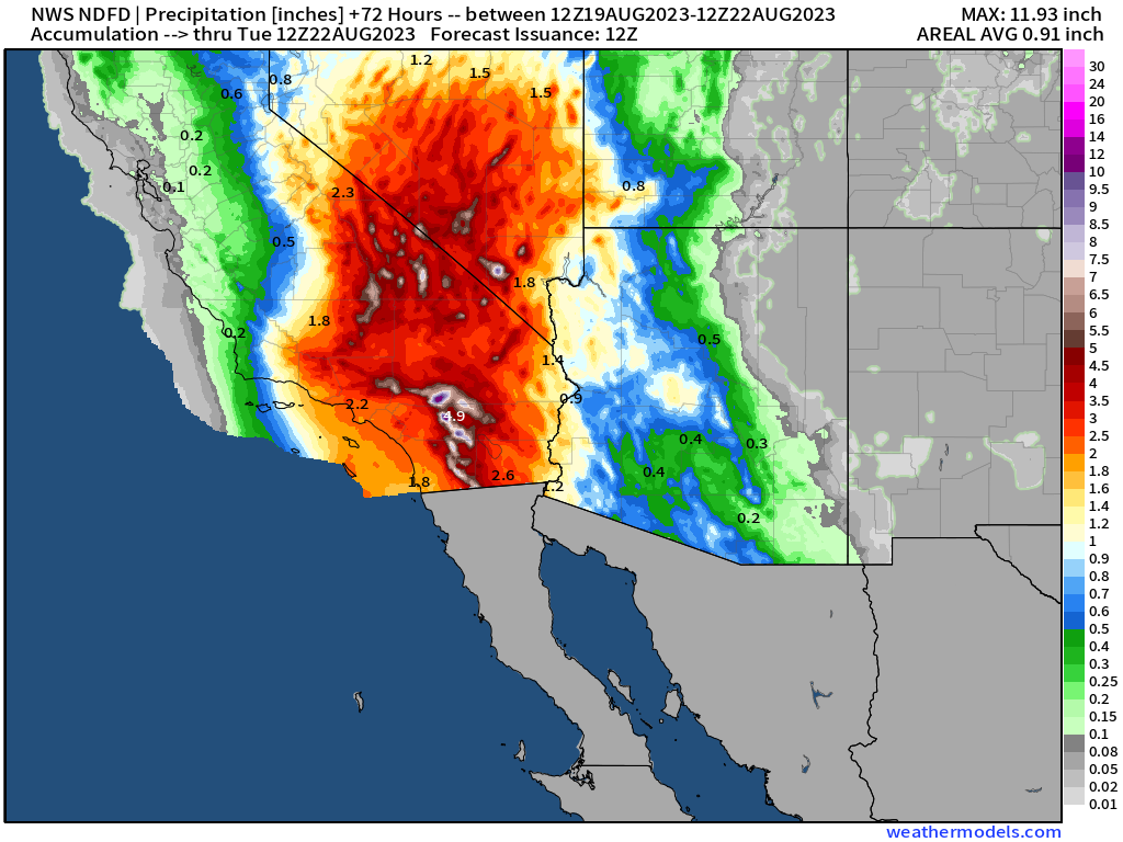
Hurricane Hilary remnants to inundate Southwest US
August 2023 was the 10th-warmest August in the 132-year national record (1895–2026), at 74.4°F against a 1991–2020 normal of 73.1°F (+1.3°F).
August 2023 was the 43rd-wettest August in the 132-year national record (1895–2026), at 2.8in against a 1991–2020 normal of 2.7in (+0.1in).
NOAA/NCEI Climate at a Glance, contiguous United States. This is the observed record for the month, not a score of anything said in this piece — the forecast ledger begins 2026-08-17 and cannot reach earlier posts.
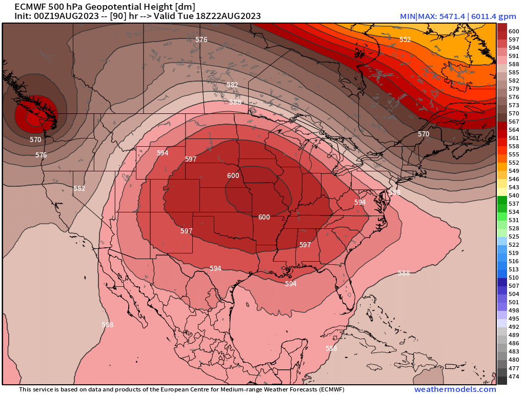
Top stories Saturday morning: (1) landfall of Hurricane Hilary on western Baja California peninsula and progress into Southern California as a named tropical system. Excessive rainfall and flooding in the deserts likely as the remnants of Hilary stream north around the “heat dome” anchored over the Central U.S.
(2) This ridge is extreme > 601 dm combined with August summertime heat is certainly the “dog days of summer” with 100°F temperatures widespread from Texas expanding to the Carolinas by early week. Dry and cloud-free.
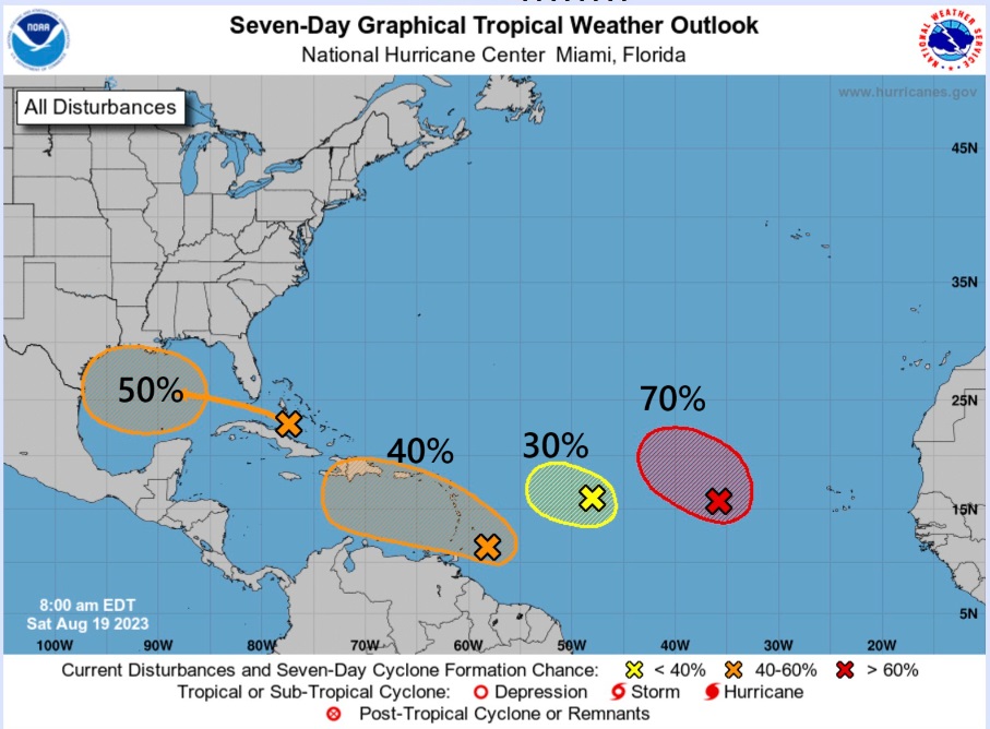
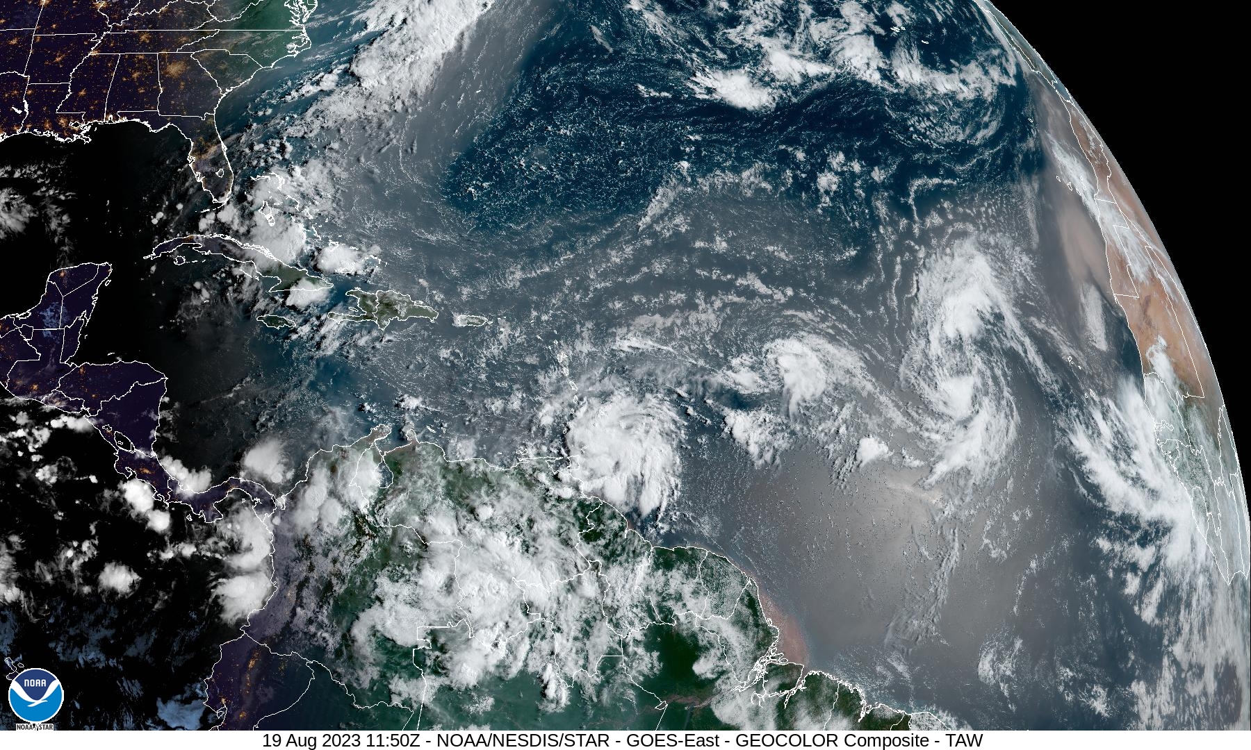
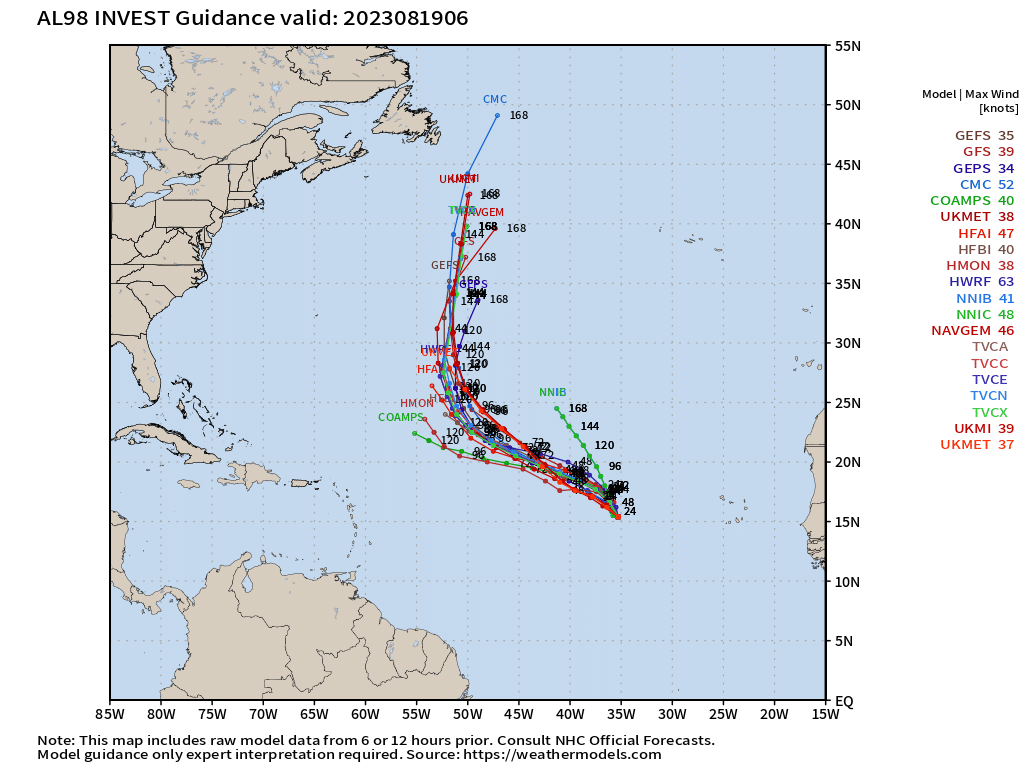
In the 7-day NHC tropical weather outlook, there are now 4 areas being watched for tropical cyclone development: Gulf of Mexico (50%) and three waves in the MDR as of Saturday morning 8 AM. Invest 90L has been newly designated for the wave entering the Caribbean. That is the most serious concern for populated areas including Hispaniola and Puerto Rico. Invest 99L (30%) and Invest 98L (70%) are unlikely to affect any land (mix fish).
Short term Atlantic Tropics
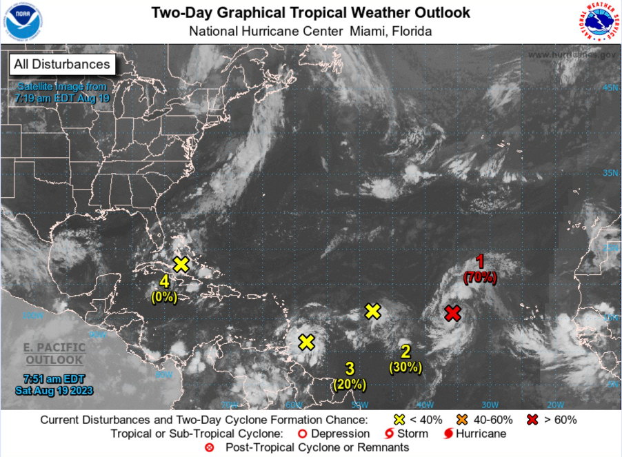
Invest 98L at 70% in the next 48-horus is the only wave at risk of imminent development. If it does so, then it would continue NW but unlikely to become very intense as the environmental wind shear and dry air are hostile. The Atlantic subtropics are not friendly to tropical systems this year primarily because of building El Niño.
On Tuesday, the Gulf of Mexico will see a very moisture rich tropical wave impact south Texas with measurable rain including Houston with 1-inch or more southward. Talk about welcome rain!
Medium Range Atlantic Tropics
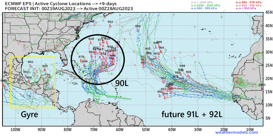
Active systems at Day 9 in the ECMWF ensembles include future waves coming off Africa in the coming days beyond 98L and 99L. The African wave train is particularly active with some candidates becoming named storms almost immediately after hitting the Atlantic ocean.
Invest 90L is the closest to U.S. but trajectory is northward, blocked by the CONUS heat dome. We will have to watch the Gulf of Mexico
Atlantic 2023 Year to Date | ACE: 17 (99% normal)
Unnamed Storm [January 2023]
Arlene 02L: 35 knots
Bret 03L: 60 knots
Cindy 04L: 50 knots
Don 05L: 65 knots
Emily
Franklin
Eastern Pacific Hurricane Season
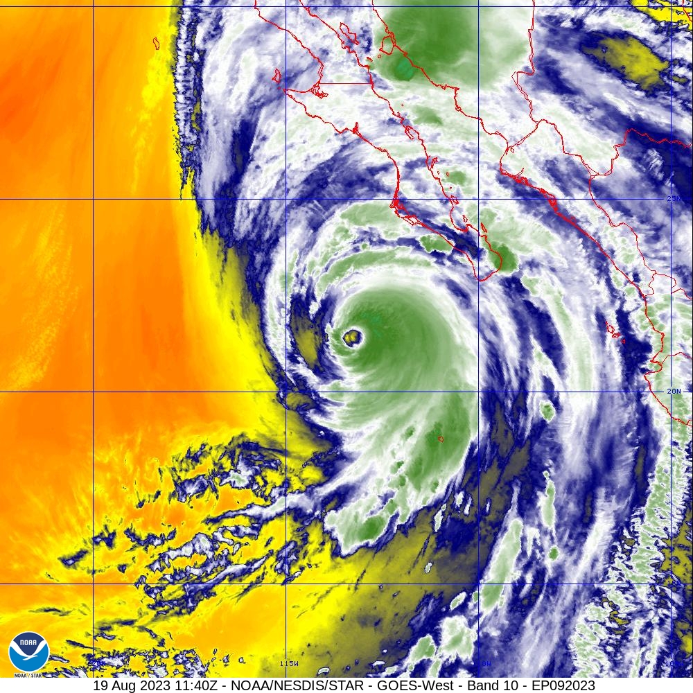
Hurricane Hilary (09E) remains a powerful 130 mph storm this morning (5 AM PT) with a well-defined, large eye and cold cloud tops surrounding it. The weakening process has yet to begin in earnest. Hilary is very large size-wise with expanding wind field and rain shield well in advance. All of southern California is under a tropical storm warning, and conditions should be impactful especially with heavy rain in desert areas that usually see a few inches of precipitation per year let alone in a couple days.
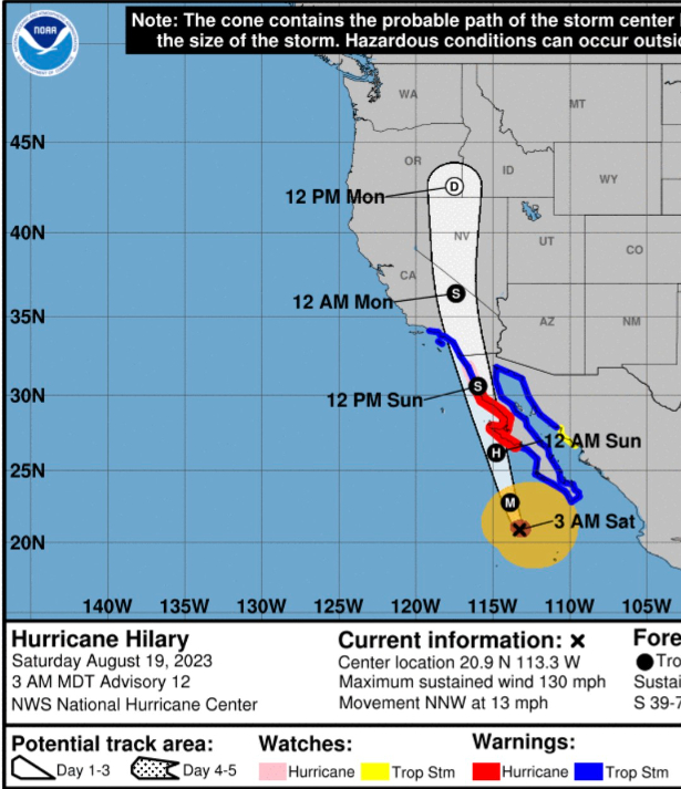
NHC snippets:
...CATASTROPHIC AND LIFE-THREATENING FLOODING LIKELY OVER BAJA CALIFORNIA AND THE SOUTHWESTERN U.S. THROUGH MONDAY... ...HURRICANE-FORCE WINDS EXPECTED ALONG THE WEST-CENTRAL COAST OF THE BAJA CALIFORNIA PENINSULA TONIGHT AND SUNDAY MORNING...

Hilary is expected to weaken to a tropical storm by midday Sunday before it
reaches southern California.
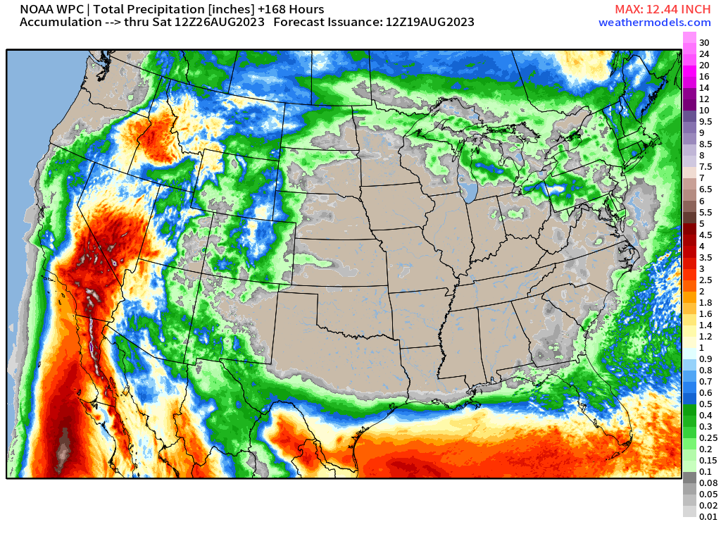
The overall rainfall will exceed 12-14 Trillion gallons across the Western U.S. states including CA, NV, AZ, UT, OR, ID, MT. This will be a major event across several states in mountainous terrain. The area of 2-4” rain with isolated amounts to 12-inches will be considerable including Los Angeles, San Diego, Death Valley and Las Vegas.
Eastern Pacific 2023 Year to Date
Adrian 01E: 90 knots
Beatriz 02E: 75 knots
Calvin 03E: 110 knots
Four 04E: 30 knots
Dora 05E: 125 knots
Eugene 06E: 60 knots
Fernanda 07E: 115 knots
Greg 08E: 45 knots
Hilary 09E: 125 knots
ACE: 98 | 161% of normal (61)
Western Pacific Typhoon Season
No suspect areas for the next week
Western Pacific Typhoon 2023 Year to Date
Sanvu 01W: 30 knots
Mawar 02W: 160 knots
Guchol 03W: 90 knots
Talim 04W: 85 knots
Doksuri 05W: 130 knots
Khanun 06W: 120 knots
Lan 07W: 115 knots
ACE: 147 | 138% normal (106)
Thank you for subscribing! Your support pays for my servers and product development. Feel free to say hello and follow on Twitter (@RyanMaue)
- Milepost
- 71 · laid 2023-08-19T12:40:22.497000Z
- Source
- https://weather.substack.com/p/august-19-2023-hurricane-season
- Digest
- b94096a53bc3e2671dffe310886792927d838a4c6e9e2bfdd88ba1bac0751eda
- Machine
- JSON