August 6, 2025 Hurricane Season Wednesday
Atlantic tropical wave showing signs of development; more development in following week
August 2025 was the 28th-warmest August in the 132-year national record (1895–2026), at 73.4°F against a 1991–2020 normal of 73.1°F (+0.3°F).
August 2025 was the 27th-driest August in the 132-year national record (1895–2026), at 2.3in against a 1991–2020 normal of 2.7in (-0.3in).
NOAA/NCEI Climate at a Glance, contiguous United States. This is the observed record for the month, not a score of anything said in this piece — the forecast ledger begins 2026-08-17 and cannot reach earlier posts.

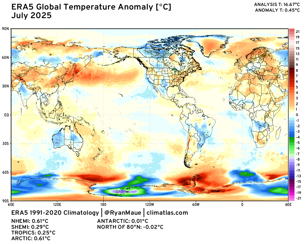
Global temperature update: July 2025 | ERA5 +0.45°C (1991-2020 baseline)
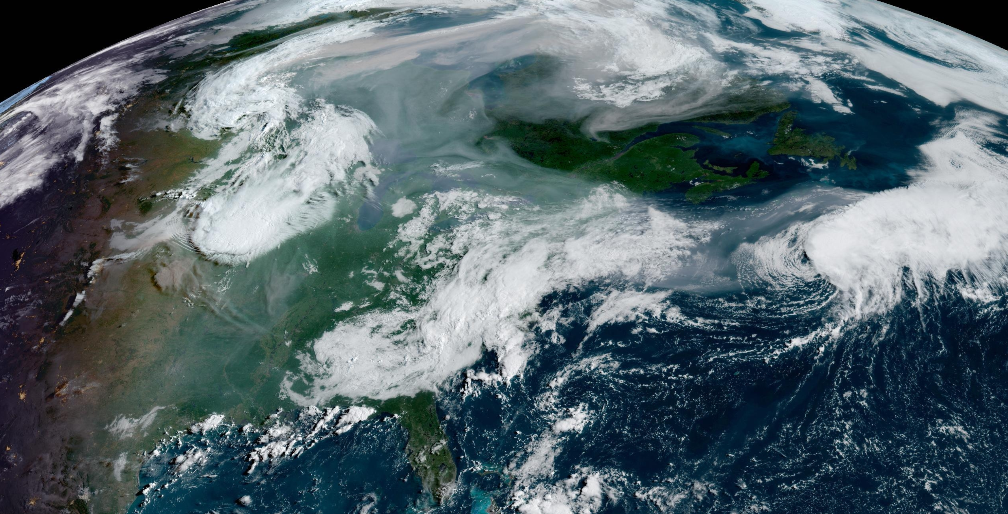
Wednesday Morning Tropical Update
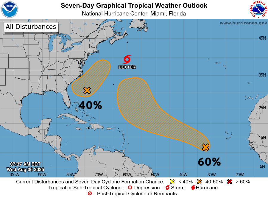
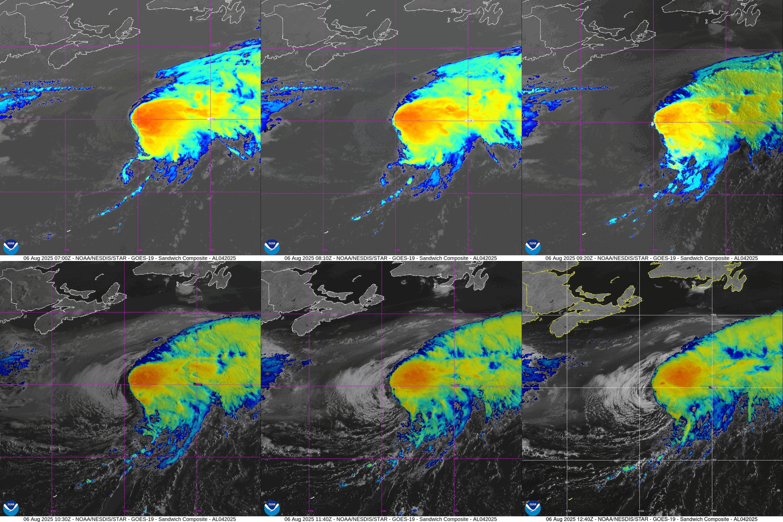
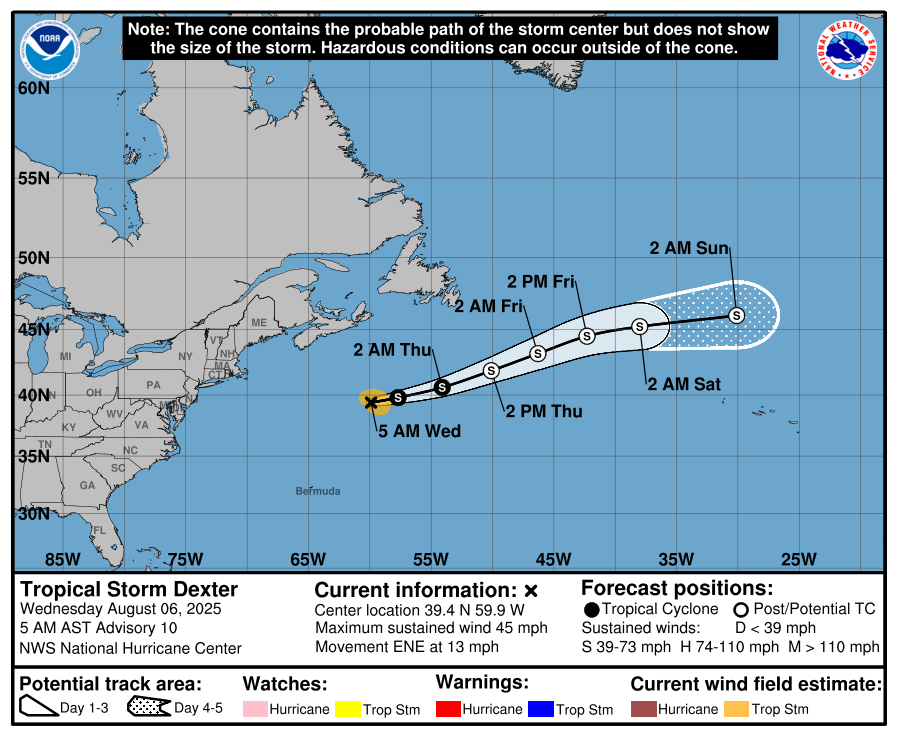
Tropical Storm Dexter (04L) battling wind shear has maintained strong convection and 45-knot winds. It will transition to a post-tropical system in the next 24-36 hours but increase intensity/winds to hurricane force. No threat to land as it heads ENE across the north central Atlantic.
Southeast USA coast (40%) disturbance along a persistent trough likely will develop into a tropical system similar to Dexter and meander. Not seeing a threat to the U.S. mainland as it heads generally NE into the open Atlantic, following Dexter.
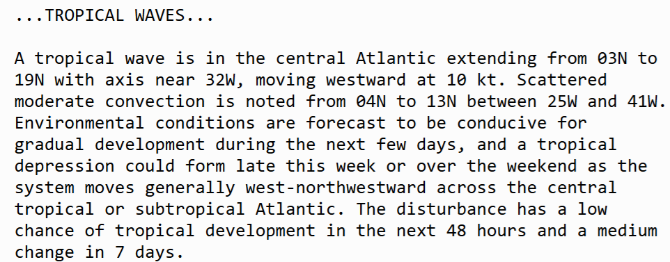
Central MDR (60%) tropical wave that emerged off Africa has remained convectively active and has a better than coin-flip chance of development in the next 7-days on a NNW track.
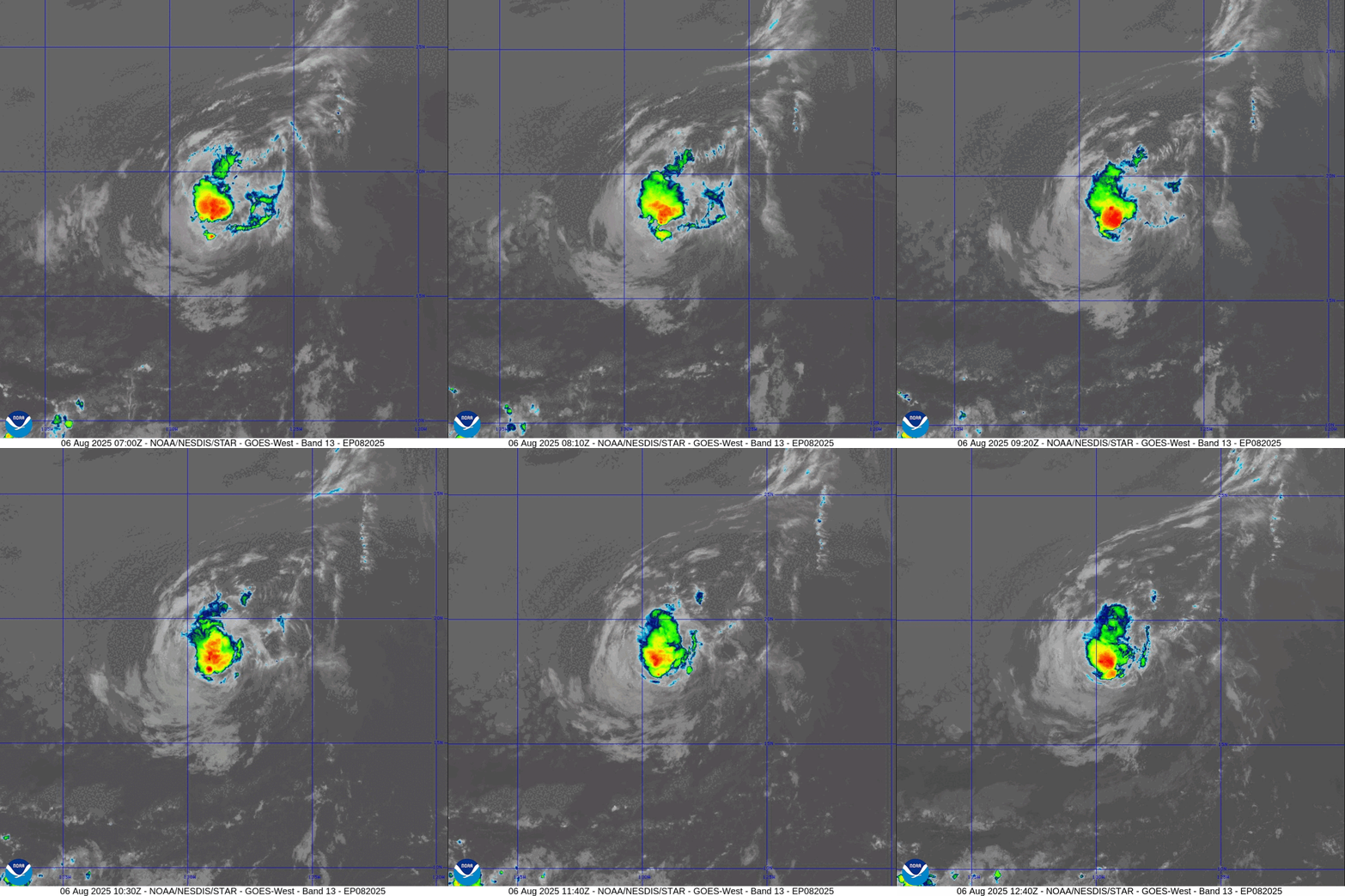
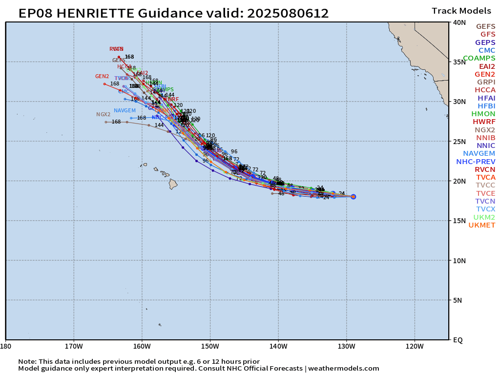
Eastern Pacific Basin Tropical Storm Henriette (08E) is a minimal system but models indicate it will survive over cooler water (24°C) northeast of Hawaii, and perhaps become a hurricane down the road.
Heading into mid-August with a more active period in the Atlantic basin —> remember that we have many models updating every 6-12 hours, and many show catastrophic or historic solutions e.g. major hurricanes near land including the U.S.
HOWEVER, nothing is imminent or set in stone. We only use models to show the “plausible” scenarios of systems that could/may develop. We have 100s of solutions generated daily — 1000s per week. Digesting this information is the job of responsible meteorologists and media — to process the data, assess the risks, and add value.
The models cannot consistently and/or skillfully look over the predictability horizon e.g. 8-10 days especially with tropical cyclones. The convection / storm clusters are not resolved by the full physics weather models at their current resolution (9 km to 25 km). Also, the A.I. models do not provide that much of an additional skill gain for individual tropical cyclones that have not yet formed.
As we watch tropical waves come off Africa in the coming days, each/every has the potential to develop especially heading into August. However, when/where and what impacts are unknown.
Subscribe or Upgrade to Annual (30% off) —> Offer available to everyone
Thank you to readers continuing into this Hurricane Season. My goal is to keep you informed about ongoing extreme weather events inside and outside of the tropics, but also a week (hopefully) heads up on what’s coming. I’ll be using a variety of weather modeling output, some of it may be unfamiliar, but it’s state-of-the-art and industry leading standard.
ECMWF 06z | Precipitable Water Next 6-days
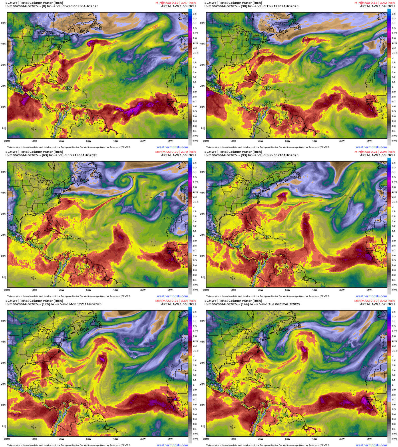
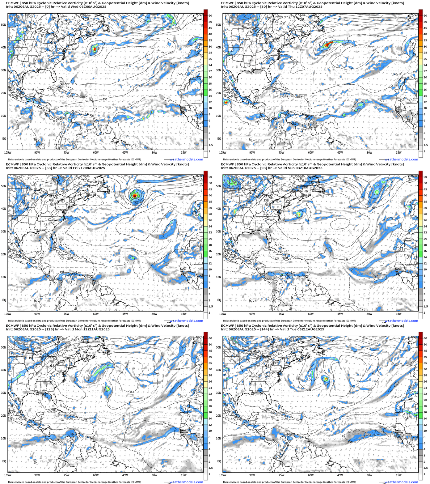
My favorite parameter: Several areas to watch in next 6-days:
Dexter heads out to sea — no impact to land — becomes a stronger extratropical system, potentially hurricane force.
Southeast U.S. — NHC has a 40% chance of development, and models support “something” weak developing but perhaps not significant enough for a named system.
Tropical waves —> current central Atlantic tropical wave (60%) —> Tropical Depression or Storm —> moves / recurves quickly northward with this ECMWF model solution (and other models). However, another wave is on its heels — and will arrive in the central MDR by Sunday. The cyclonic relative vorticity shows the small system gain latitude and combine with whatever develops off the U.S. Northeast coast.
ECMWF 00Z | Integrated Vapor Transport Next 10-days | Atlantic Basin
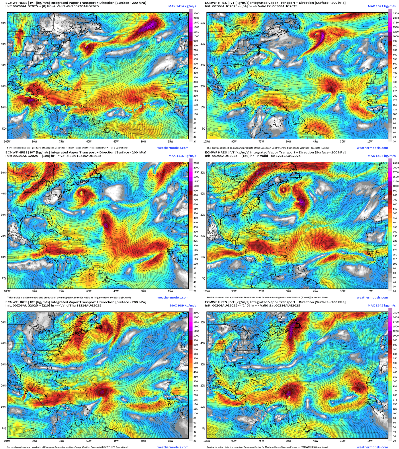
+Moisture transport vectors from the 00z flagship solution — we can see the various tropical systems over the Atlantic basin. It seems we have indeed “flipped the switch” into mid-August. This 00z cycle has 3 coincident storms (or ex-storms) with a southern-most wave reaching the Caribbean. However, after Days 6-7, higher uncertainty especially with tropical cyclone genesis. The MDR wave train is much more robust than the last few weeks, for sure.
Atlantic Basin Outlook
Tropical Storm Dexter is a strongly sheared with the low-level circulation exposed. However, the convection is vigorous.
Dexter becomes post-tropical on Thursday
Atlantic Satellite Imagery | True Color and Infrared
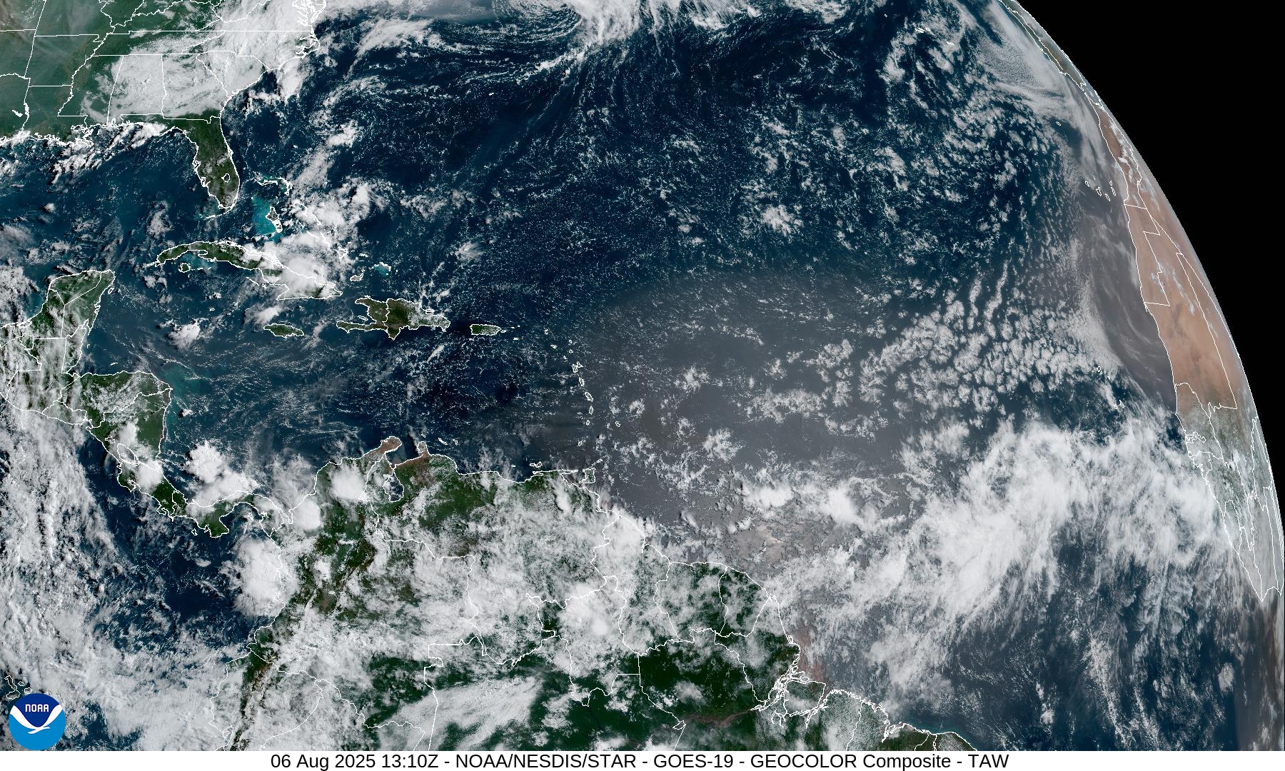
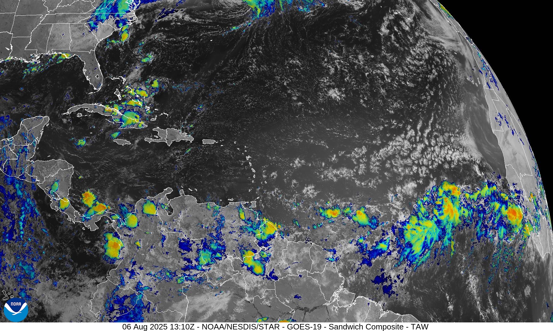
Moderate convection in the MDR along the monsoon trough / ITCZ with the active tropical wave (60%). This Atlantic tropical wave is better looking that most we’ve seen in recent weeks.
Eastern Atlantic & Tropical Africa | Satellite Image
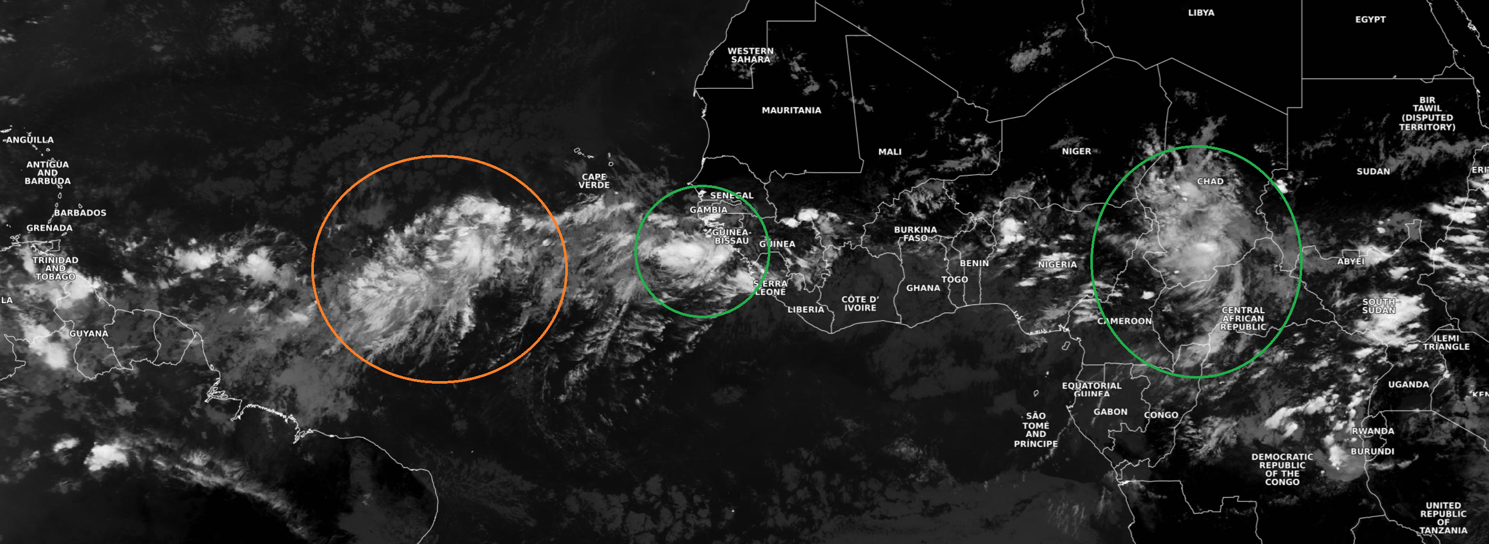
Dust / Saharan Air Layer just to the north of the wave axis will be an inhibiting factor.
NASA GEOS-5 | 00z DUST Aerosol Optical Depth | 8-day Forecast
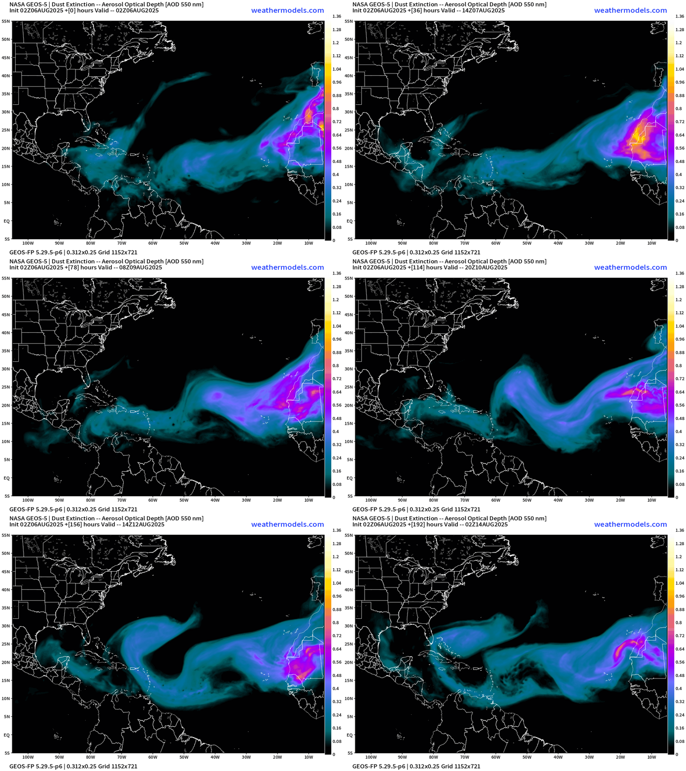
Plumes of Saharan dust coming off African continent to north of tropical wave and monsoon trough/ITCZ and any tropical waves must contend with this negative influence on its trek westward across the Atlantic MDR.
Atlantic Ocean Surface Temperatures (SST) + Anomaly (vs. last 20-years)
Ocean temperatures remain abnormally warm in the subtropics off the U.S. East Coast to Bermuda. The MDR is near normal. It’s the “actual temperature” that matters as well as the difference between subtropics and tropics that contributes mostly to genesis.
NOAA Tropical Surface Analysis | 06z
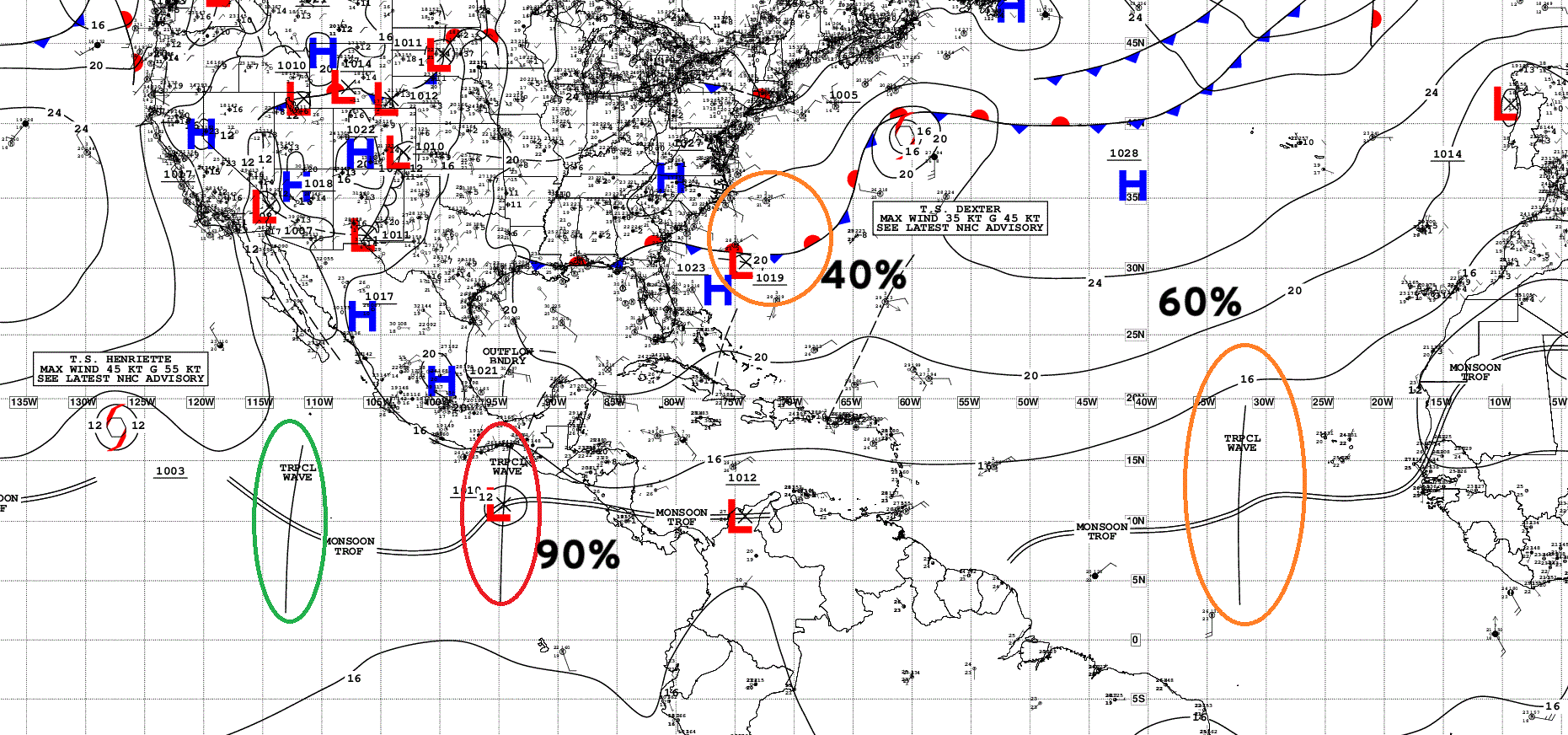
Atlantic Tropical Waves = 1 (60% development chance NHC)
ECMWF AIFS-Single Consistently Develops A Hurricane | 06z
Keeping an eye on “social media” favorite AIFS-Single, which has replaced GFS as the “hot new thing” since it consistently generates a major hurricane off the U.S. East Coast in the 14-15 days range.
This is “way over the horizon” of predictability and only a possible/plausible track scenario that exists in every hurricane season in August and September since 1995.
GFS 06z does NOT develop a Hurricane
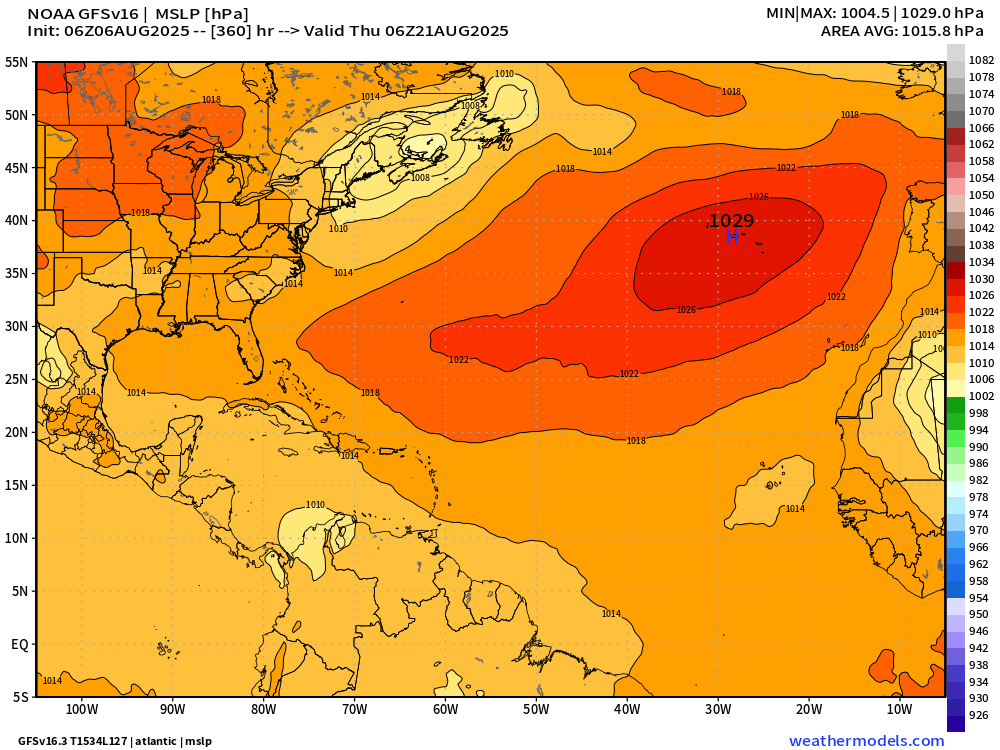
Amateur weather accounts and content creators are disseminating GFS across social media, but probably not this morning as the model has NO tropical storm or hurricane sitting off the U.S. East Coast.
GEFS Ensembles 06z | Active Tracks through Day 15
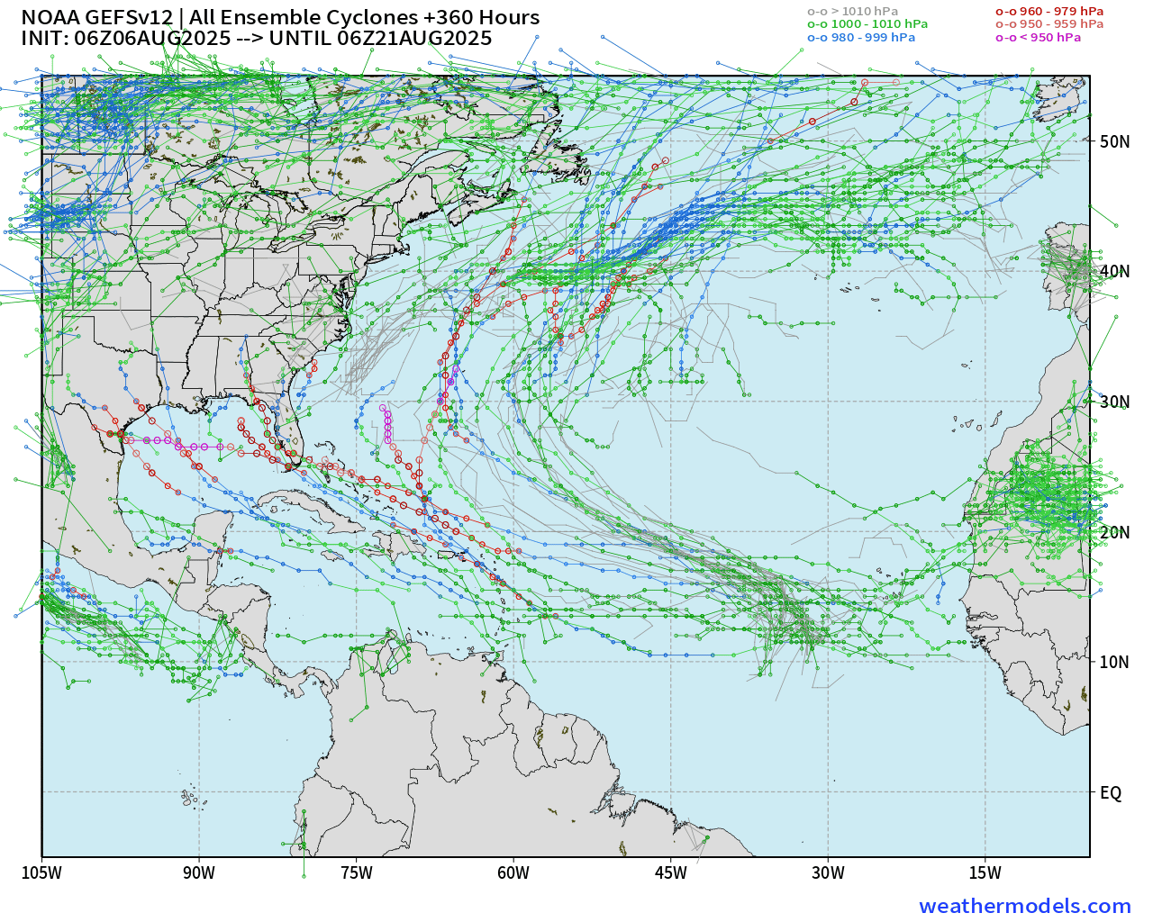
I don’t typically show the GEFS ensembles since the GFS is technically not a member. However, we can add context because the GEFS has a similar convective scheme and components under the hood. Through Day 15, many solutions out of the 31 members that have TS/HU in the western half of the Atlantic basin.
The best / proper way to forecast tropical systems is with ENSEMBLES
Medium range ensemble model outlook
These are 51-realizations of the same model with different initial conditions. Each ensemble gets equal ~2% weight in a mean calculation.
ECMWF Ensembles 06z | Day 6 Active Tracks
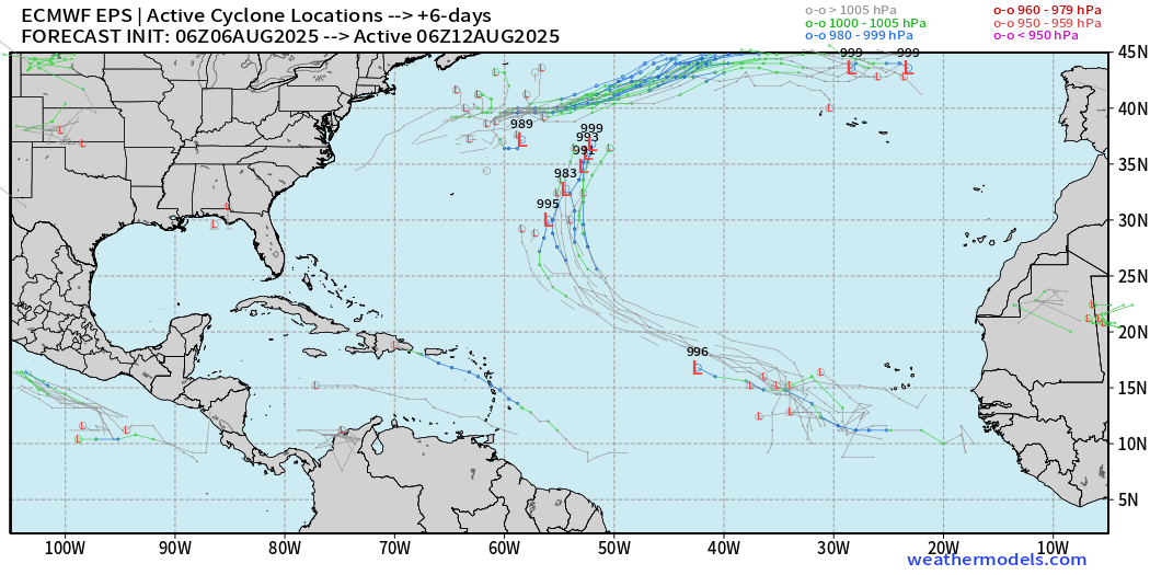
Full-physics conventional model —> central MDR tropical wave could become a weak TD/TS in next 48-72 hours but battle dry air and dust. More favorable environment to the north in the subtropics in 5-6 days, assuming the system survives.
ECMWF Ensembles 00z | Day 11 Active Tracks
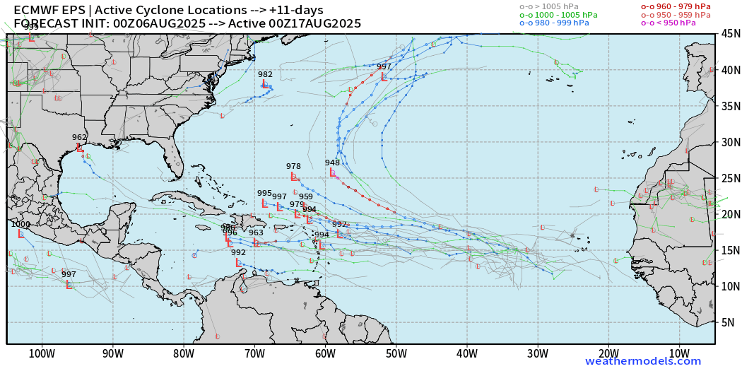
A tropical wave in the MDR has a wide envelope of track solutions from the Caribbean to NE of Greater Antilles. Many members with HU/Major.
The majority of EPS full-physics ensemble members (00z) have a major hurricane by Day 15.
ECMWF Ensembles 00z | Day 15 Active Tracks
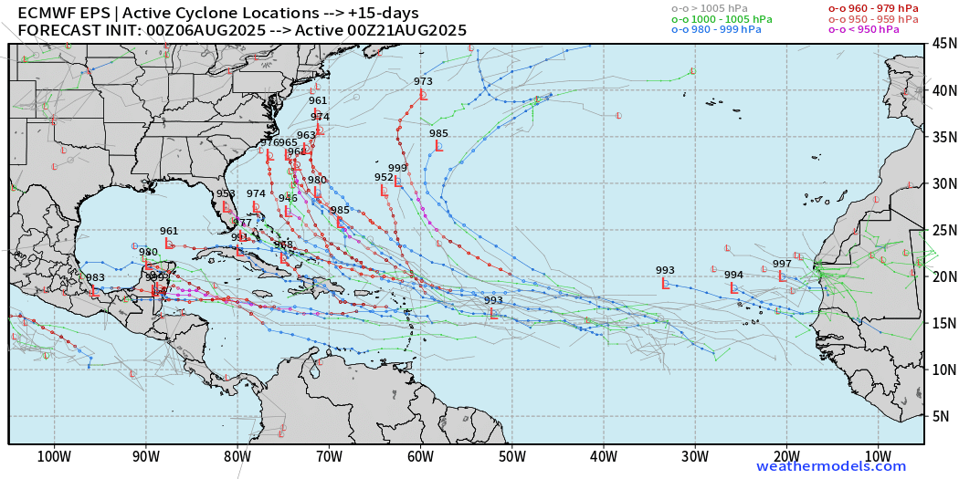
Major hurricanes everywhere — and too many to count on a westward track through Caribbean, into Gulf, and off the U.S. East Coast.
HOWEVER, these systems are 8 to 10 days before formation and then 14 days before nearing land. That’s way over the predictability horizon. These ensemble plots are scenarios and should be judged as potential risks.
AIFS Ensembles 06z | Day 7 Active Tracks
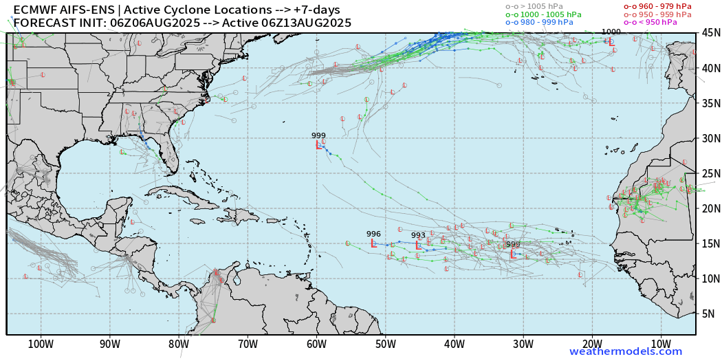
The next tropical wave showing signs in the MDR.
AIFS Ensembles 06z | Day 11 Active Tracks
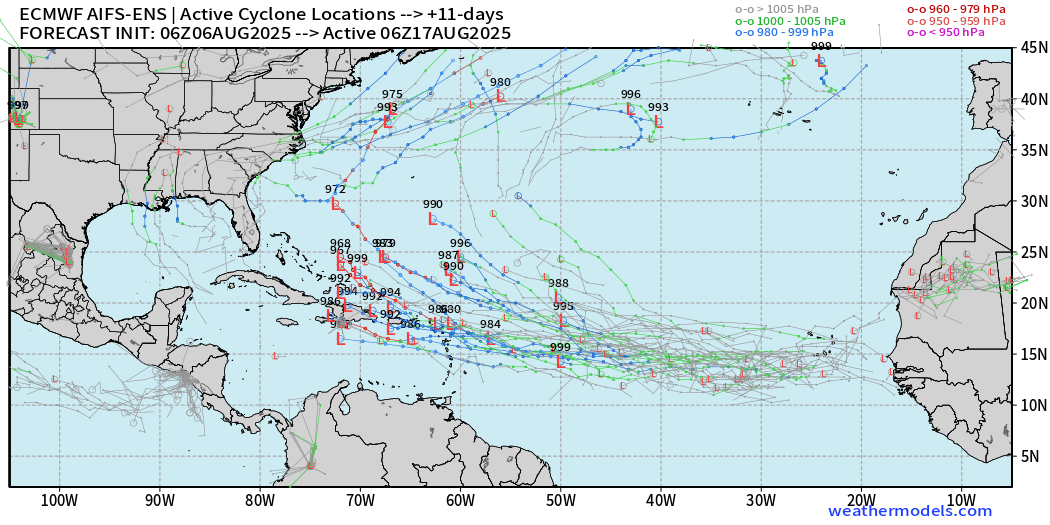
Compare with AIFS Ensembles 12z | Day 15 Active Tracks
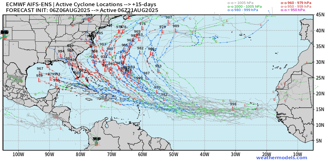
Two clusters — westward through Caribbean into Gulf, and then off the U.S. East Coast with recurving hurricanes.
Conclusion from these ensemble tracks: risk increases for hurricane activity past Day 10 in the western Atlantic basins.
Eastern and Central Pacific Tropical Update
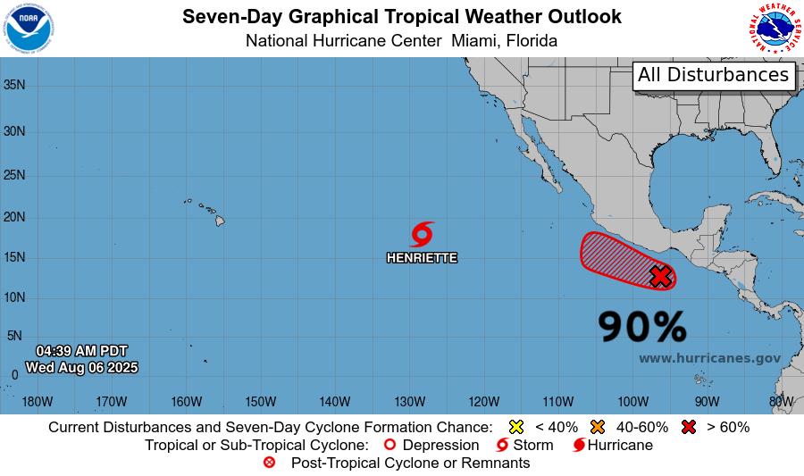
Henriette and Invest 91E —> not very impressive this morning.
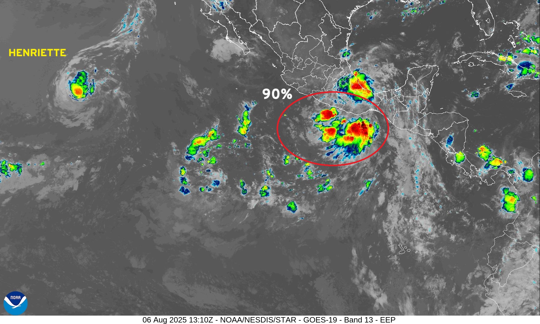
Henriette has convection near the center and a large circulation. It may survive over much cooler water than usual due to low wind shear.
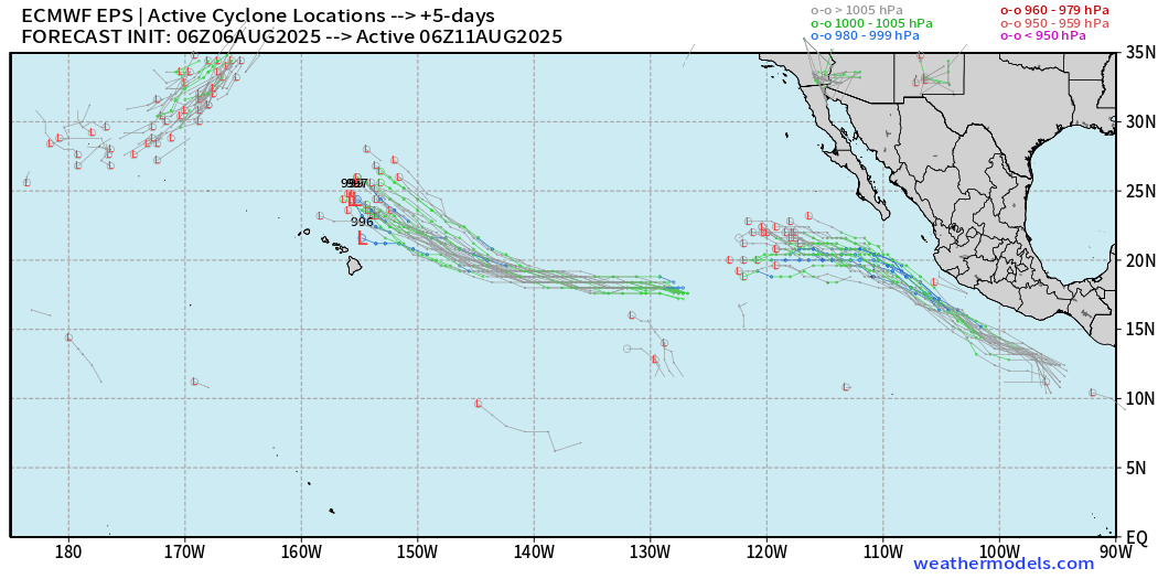
In 7-days, Henriette could reach warmer waters and re-intensify into a Hurricane or Typhoon, if it crosses the Dateline.
The system along the coast of Mexico will be named Ivo. Active tracks in 5-days
Western Pacific Tropical Update
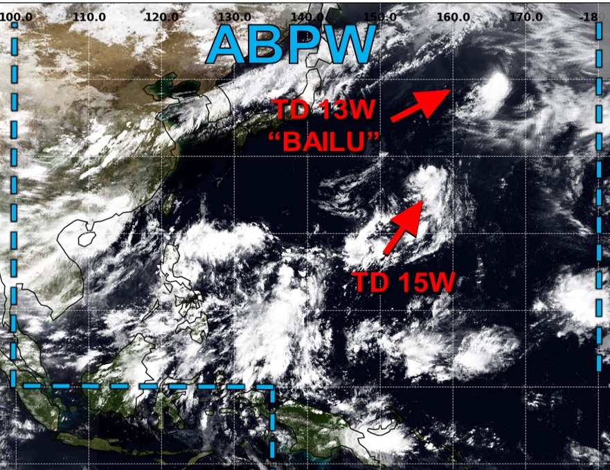
TD 15W may drift westward in some ensemble members.
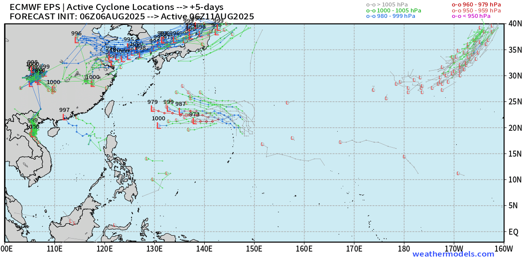
Otherwise, quiet at Day 5.
Maps sourced from weathermodels.com designed and innovated by yours truly! Please subscribe there for real-time access to the newest maps, charts from all of the weather models including ECMWF.
- Milepost
- 693 · laid 2025-08-06T14:28:24.320000Z
- Source
- https://weather.substack.com/p/august-6-2025-hurricane-season-wednesday
- Digest
- f0a516612f2d735b8a358ae3d536c88ab221f7199b269f8173889250ae9a68bd
- Machine
- JSON