August 2, 2023 Hurricane Season
Hurricane Dora 05E is rapidly intensifying
August 2023 was the 10th-warmest August in the 132-year national record (1895–2026), at 74.4°F against a 1991–2020 normal of 73.1°F (+1.3°F).
August 2023 was the 43rd-wettest August in the 132-year national record (1895–2026), at 2.8in against a 1991–2020 normal of 2.7in (+0.1in).
NOAA/NCEI Climate at a Glance, contiguous United States. This is the observed record for the month, not a score of anything said in this piece — the forecast ledger begins 2026-08-17 and cannot reach earlier posts.
Watching the Tropical Update with John Hope on the Weather Channel back in the 90s, I was fascinated when he went over to the Eastern Pacific usually right off the coast of Mexico to show a monster hurricane. The first hurricane season I remember following on a daily basis was 1995 when activity stepped up a notch with flip in Atlantic Multidecadal Variability (AMV) signal to the so-called “active era” that (maybe) continues today.
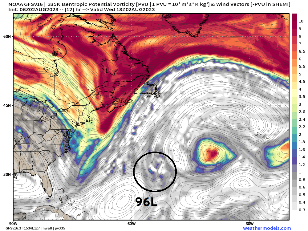
Invest 96L has been written off (10%) by the NHC in their tropical weather outlook this morning. The upper-level feature to its ENE as well as the approaching trough have created an unfavorable environment with directional wind shear. The showers and storms are disorganized. This system was honestly expected to develop and had a 70% chance (red cherry) and it did not. Interest if this is an omen for the rest of the season as El Niño kicks in.
Sea surface temperature anomaly pattern indicative of a canonical El Niño with a warm tropical Atlantic
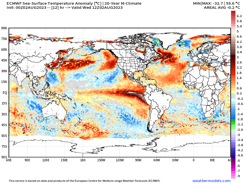
Using a 20-year model climate instead of 30 or 1991-2020 might provide a better indication of the patterns at play. It is not clear to me what climatology period would be best or more informative or if it even matters what happened in the past 20 or 30 years to form that anomaly. It’s the actual SST that does anything, after all.
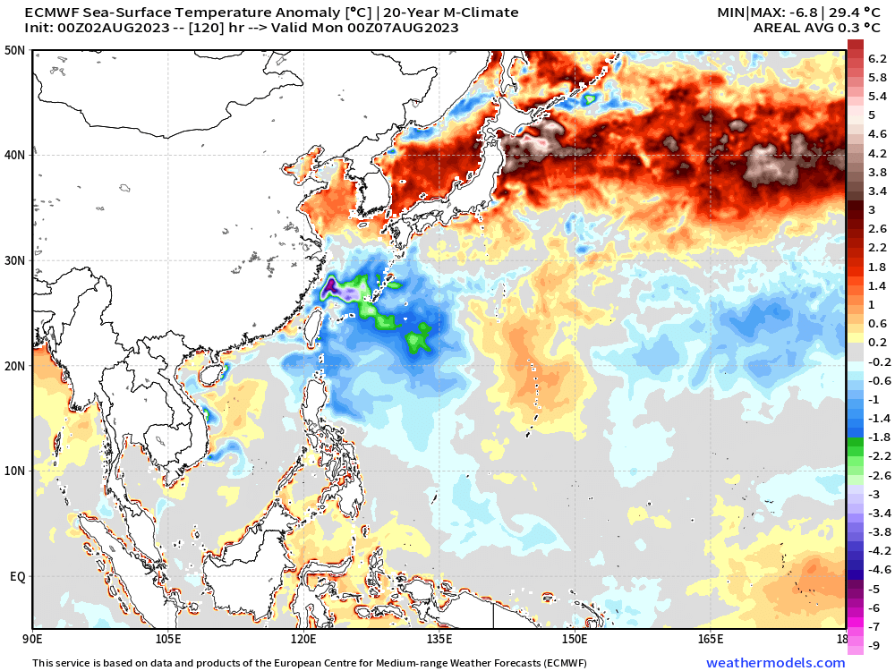
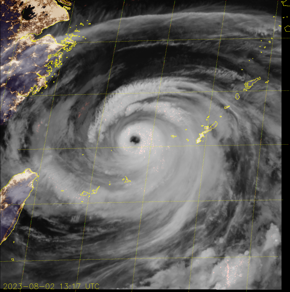
The recent typhoon activity — Doksuri and Khanun — have cooled down the western Pacific north of the Philippines and south of Japan. And, Khanun [06W] continues to slowly churn up cooler water from depth and lower the SST further with its stall tactics. It is also a rather large Typhoon with a broad wind field. This will certainly leave a huge cold wake and negative SST anomaly footprint. The coupled ECMWF HRES forecast +5 days shows a large area of 2°C cool anomaly.
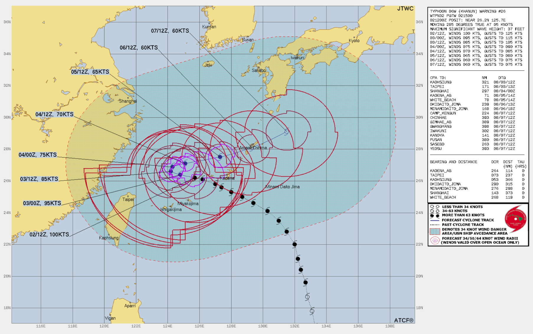
JTCW forecast for Typhoon Khanun (06W) at 1500 UTC on August 2, 2023
Near-term Atlantic Activity
End of the road for Invest 96L from NHC tropical discussion 10% (2-day) and 10% (7-day)
A 1015 mb low pressure, Invest AL96, is well east-southeast of
Bermuda near 28N58W, moving NW. A surface trough reaches
northeastward from 26N62W through AL96 to 30N56W. Scattered
moderate convection and strong SE winds continue within 240 nm of
the center in the eastern semicircle. Seas in the area are 8 to 11
ft. This system has a low chance of developing into a tropical
cyclone during the next 48 hours.
I am currently working with Pangu-Weather and FourCastNet A.I. powered weather forecast data, and showed some examples on Twitter (@RyanMaue). I am also interested in the climatology of 90°F and 100°F across the United States — and globally! I am calculating global heat index from reanalysis from 1940-2023 to visualize the trend in apparent temperature. And finally, putting the global climate crisis of the 1870s into context of today’s transition from multiyear La Niña to El Niño.
Extended range Atlantic Tropics: Next 2-weeks
The ECMWF ensembles [August 2, 2023 00z] have become more active with a tropical wave in the central MDR developing in 7-days and then heading WNW into very favorable area of intensification.
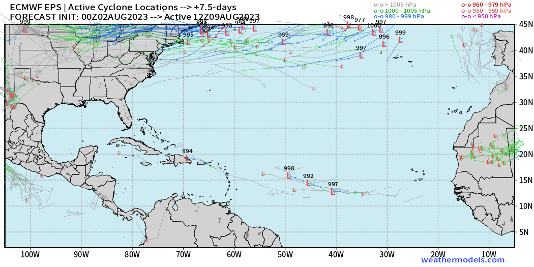
Day 7.5 ECMWF EPS ensemble tracks (weathermodels.com)
But look at Day 12! Count on your fingers and find at least 13 hurricanes or major hurricanes out of 51 ensembles, so the wave development % is about 25%. That’s a little higher than climatology, so this bears watching in forecast model world for the next few days.
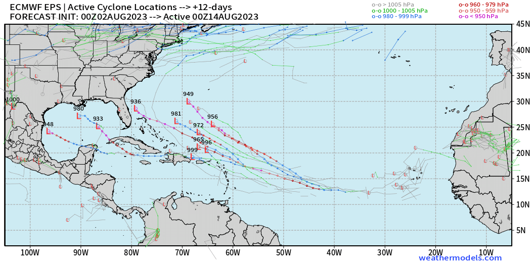
Day 12 ECMWF EPS ensemble tracks (weathermodels.com)
Note, this map is a compilation of 51-ensembles of storm tracks from the model output. The active storms at Day 12 are indicated with their tracks and the Low location along with the current minimum sea-level pressure. This does not mean there will be 4 hurricanes, but out of 51 ensembles, 4 generate a hurricane, which is < 10% chance, and that is a very weak signal.
Atlantic 2023 Year to Date
Unnamed Storm [January 2023]
Arlene 02L: 35 knots
Bret 03L: 60 knots
Cindy 04L: 50 knots
Don 05L: 65 knots
Emily is next!
Eastern Pacific Hurricane Season
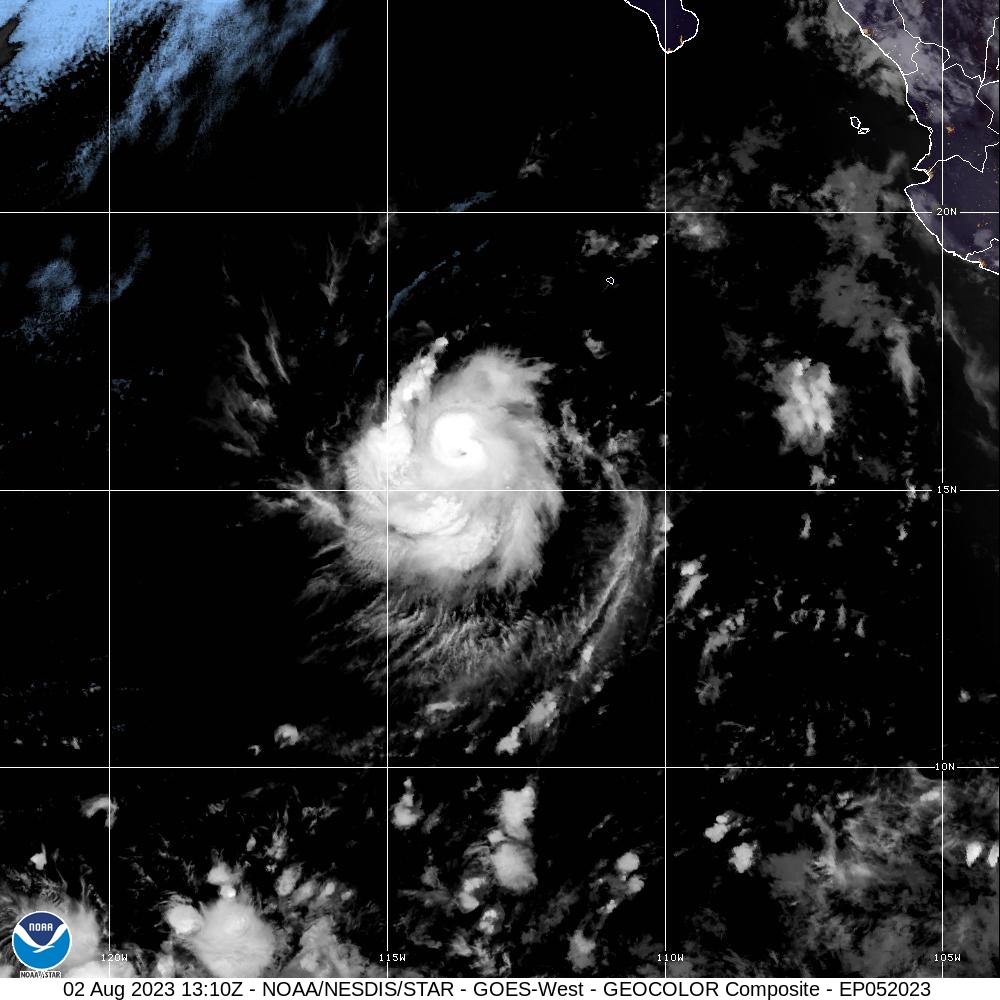
Dora (05E) continues to rapidly develop well off the coast of Mexico and is moving WSW — unusual — as it will track along 10°N to 15°N avoid cold water and head into the central Pacific. That’s got some El Niño vibes. Eugene will develop in 4-5 days and parallel the Mexico coast and hopefully invigorate the SW U.S. monsoon.
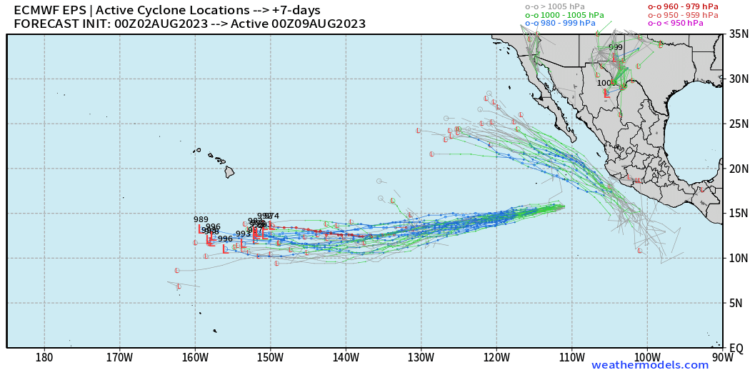
Go Dora Go!
Dora is still rapidly intensifying and is well on its way to
becoming a major hurricane.

FORECAST POSITIONS AND MAX WINDS

INIT  02/0900Z 15.8N 112.6W   80 KT  90 MPH
 12H  02/1800Z 15.7N 114.6W   95 KT 110 MPH
 24H  03/0600Z 15.4N 117.4W  110 KT 125 MPH
 36H  03/1800Z 14.8N 120.5W  110 KT 125 MPH
 48H  04/0600Z 14.4N 123.5W  100 KT 115 MPH
 60H  04/1800Z 14.0N 126.8W   90 KT 105 MPH
 72H  05/0600Z 13.5N 130.0W   85 KT 100 MPH
 96H  06/0600Z 12.9N 136.2W   80 KT  90 MPH
120H  07/0600Z 12.7N 142.6W   75 KT  85 MPH
Eastern Pacific 2023 Year to Date
Adrian 01E: 90 knots
Beatriz 02E: 75 knots
Calvin 03E: 110 knots
Four 04E: 30 knots
Dora 05E: Forecast 110-knots [Major Hurricane]
ACE: 27 | 62% of normal (43)
Western Pacific Typhoon Season
Typhoon Khanun [06W] 100-knots | Category 3 has a large 20 nm eye with a giant 90 nm moat surrounding the tight inner core indicative of Eyewall Replacement Cycle (ERC) underway. The ERC will likely weaken the maximum sustained winds but broaden the wind field even further allowing for the upwelling of cooler water. 06W could see “rapid weakening” to tropical storm strength in a few days.
This remarkable weakening happens infrequently with weak steering currents. Not every storm has the benefit of perfect environmental circumstances. That is a statement that underpins much of the scientific nuance in the tropical cyclones and hurricanes science space. Also, the cooler water upwelled from below and warmer water forced below has a climate memory footprint. (good topic for a blog)
FORECAST DISCUSSION: TY 06W (KHANUN) IS FORECAST TO CONTINUE
WEST-NORTHWESTWARD OVER THE NEXT 36 HOURS. DURING THAT TIME, AN
ONGOING ERC WILL INDUCE LIMITED SHORT TERM WEAKENING THAT WILL
EVENTUALLY BE EXACERBATED BY UPWELLING OF COOLER WATERS BENEATH
06W. THIS UPWELLING TAKES PLACE NEAR TAU 36, THE STR OVER THE
YELLOW SEA BEGINS TO SHIFT WESTWARD AND BLOCKS ANY FURTHER MOVEMENT
TOWARDS MAINLAND CHINA. AS TRACK SPEEDS GRIND TO A HALT, UPWELLING
BEGINS TO QUICKLY WEAKEN THE SYSTEM. BY TAU 48, THE SYSTEM IS
FORECAST TO MOVE GENERALLY EAST-NORTHEASTWARD EVENTUALLY PICKING UP
SPEED WHILE CONTINUING TO WEAKEN. BEYOND TAU 72 HAS SEEN SOME OF
THE GREATEST RUN TO RUN VARIABILITY, THANKS IN PART TO RIDGING, OR
LACK THEREOF, TO THE NORTHEAST OF THE SYSTEM AS IT ONCE AGAIN
PASSES KADENA AB. FOR THE TIME BEING, THE PREPONDERANCE OF MODEL
GUIDANCE, BOTH DETERMINISTIC AND ENSEMBLE, LENDS SLIGHTLY HIGHER
CREDENCE TO A PERSISTENT EAST-NORTHEASTERLY COURSE FOLLOWING TAU
72.
Western Pacific Typhoon 2023 Year to Date
Sanvu 01W: 30 knots
Mawar 02W: 160 knots
Guchol 03W: 90 knots
Talim 04W: 85 knots
Doksuri 05W: 130 knots
Khanun 06W: 115 knots + (ongoing)
ACE: 116 | 149% normal (78)
- Milepost
- 58 · laid 2023-08-02T13:49:11.847000Z
- Source
- https://weather.substack.com/p/august-2-2023-hurricane-season
- Digest
- a9908004898a2a84c2a1838cc6c64bd41f8460167bec0576537b3d96126277e6
- Machine
- JSON