January 14, 2025 Severe Arctic Blast
Models swerved into a much more severe winter weather
January 2025 was the 33rd-coolest January in the 132-year national record (1895–2026), at 29.2°F against a 1991–2020 normal of 32.3°F (-3.2°F).
January 2025 was the 5th-driest January in the 132-year national record (1895–2026), at 1.4in against a 1991–2020 normal of 2.3in (-1.0in).
NOAA/NCEI Climate at a Glance, contiguous United States. This is the observed record for the month, not a score of anything said in this piece — the forecast ledger begins 2026-08-17 and cannot reach earlier posts.

Good evening. As we head into the second half of January, a very cold pool of Siberian + Canadian Arctic air will surge south into the Lower 48 for by far the coldest air of the Winter.
Over the past several days, it looked like the intensity of the Arctic blast was waning and shorting in time and scope with much stronger Pacific influence. But, what’s happened is the trough axis has elongated more toward the Southwest U.S. allowing the cold air to extend through and linger in Texas for an extra day or so.
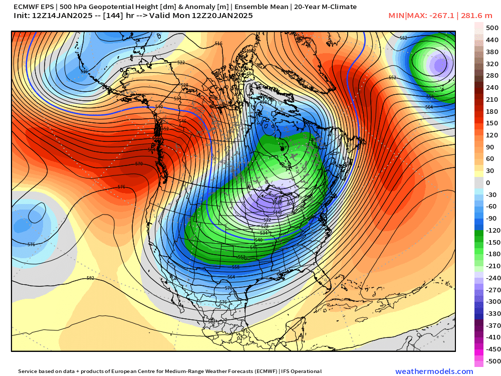
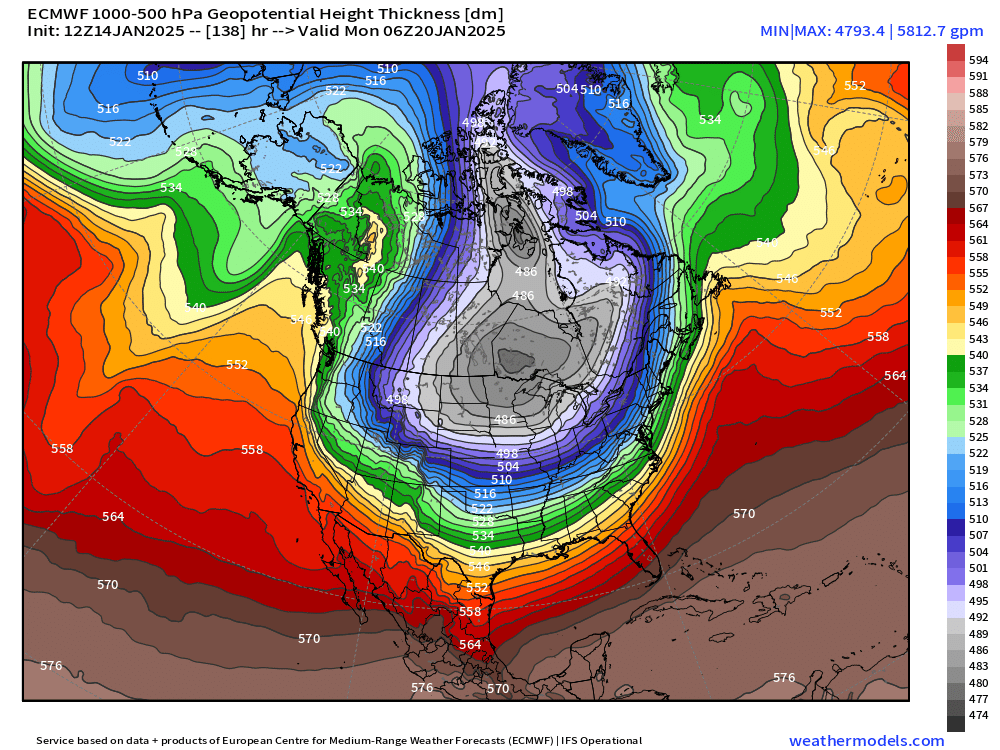
This upper level pattern at Day 6 (next Monday) is textbook extreme cold air outbreak. However, there are other complimentary ingredients including a deep cold pool over Canada, inclusion of Siberian / trans-polar air, and formation of very strong surface high pressure over snow cover in the Canadian Rockies, and then down front range of U.S. continental divide.
The subtle adjustment of the trough axis sets the stage for a very cold 5-6 day period across the entire Lower 48, and significant threat of winter weather along the margin of the Arctic cold pool including Texas into the Southeast. Houston to Atlanta and points in between all have better than a coin-flip chance of seeing some snowfall. While it’s too early to panic about freezing rain or snow in Texas or in Florida, this is the weather pattern for it — just like last Friday.
Wednesday is quiet
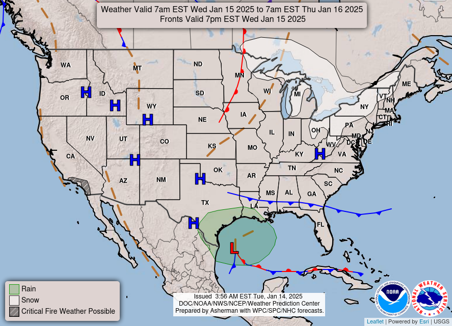
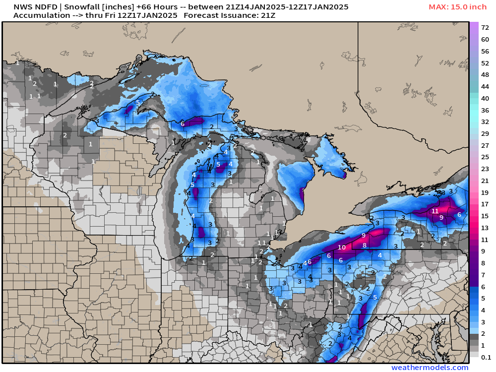
A well earned break from harshness of winter across much of the Lower 48 as warmer air pushed east from the Pacific. That will largely put an end to the Lake Effect snowfall, which has piled up in the Great Lakes.
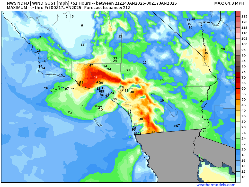
Santa Ana Winds continue to pulse during the afternoons
Still potential of 40-60 mph wind gusts around Los Angeles over the next days.
Massive Arctic Blast | 15-day Temperature Anomaly
EPS 12z Ensemble Mean
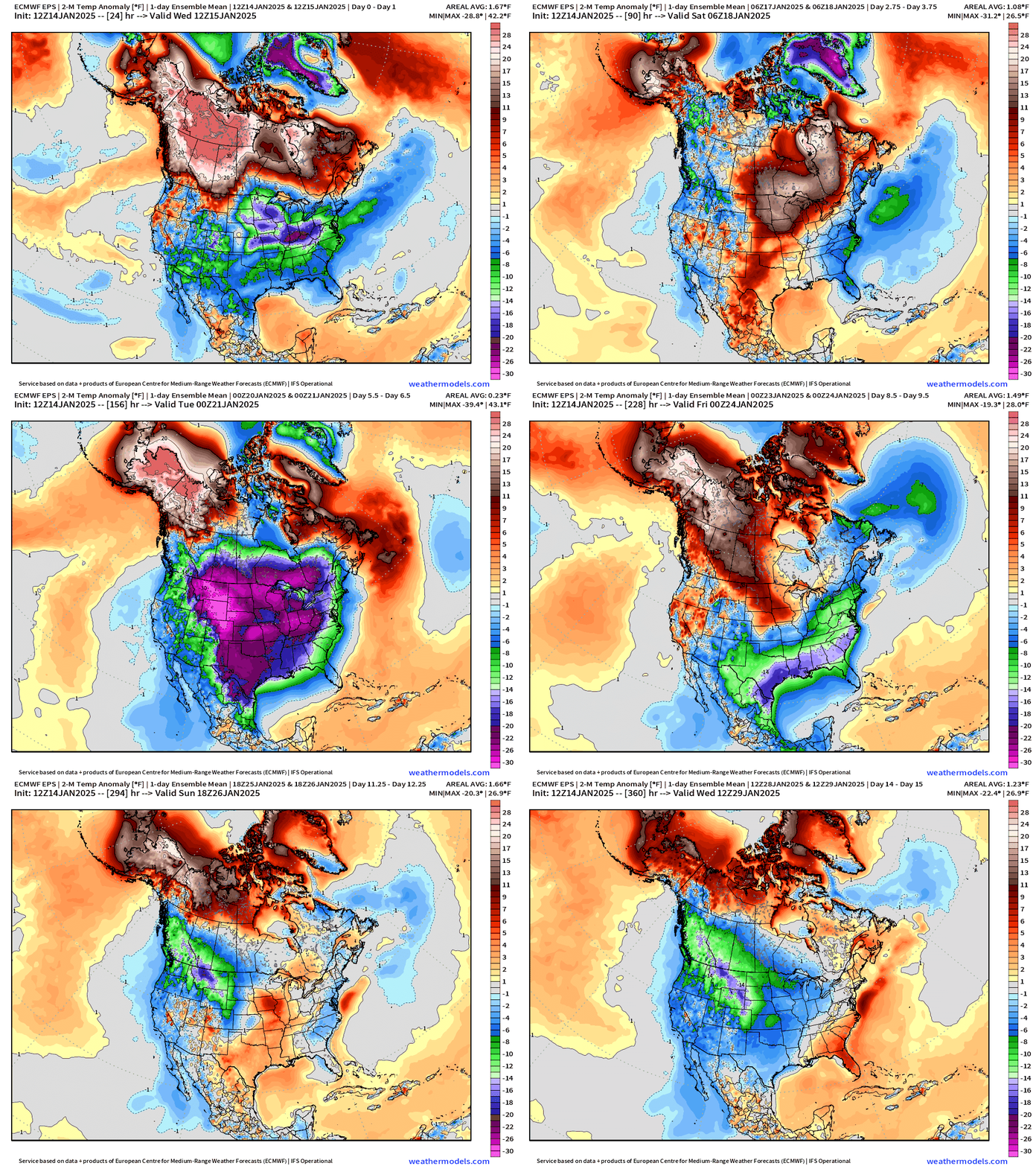
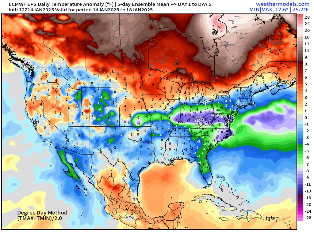
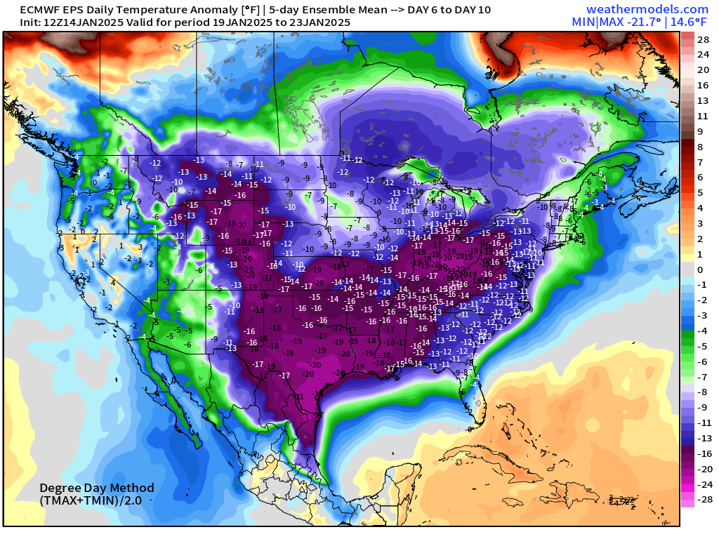
At least through the weekend, the well above normal warmth across Canada looks poised to thaw out the Lower 48, but then whoosh! As quickly as the ridging steps aside, the door is opened to the Arctic freezer and the brutally cold air floods south.
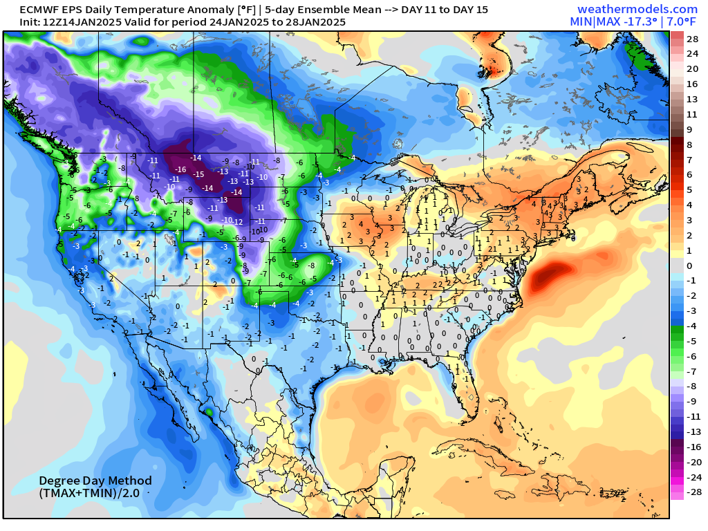
The scale and longevity of the cold is impressive, but thankfully will moderate past Jan 24th. Then, it seems the Western U.S. including the so-far winter starved Pacific Northwest will go below normal. Still waiting for atmospheric rivers to return to California, but not looking good for the next 2-weeks.
My Favorite Variable: Precipitable Water Next 10-days
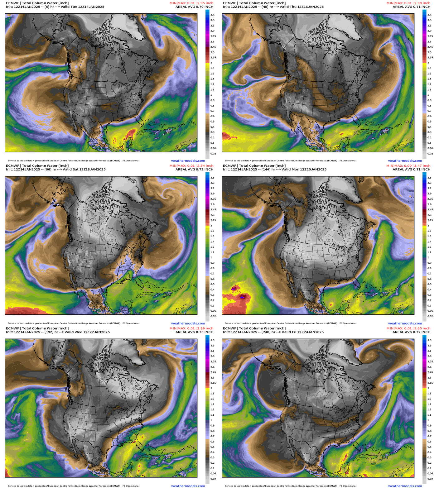
The time for the coldest Polar/Greenland origin air to travel to California or across the Rio Grande into Mexico is < 5 days. Note, the very treacherous surges of warm/moist Pacific subtropical and Gulf of Mexico origin air that impinges on the margins of the Arctic cold pool. This overrunning precipitation regime sets the stage for really bad winter weather outcomes in locations not accustomed to such severe conditions.
Peak of Arctic Blast | Tuesday January 21, 2025
Ingredients for severe winter weather impacts
Very high Canadian High Pressure over 1050 mb in the Central Plains = maintenance and even intensification of cold pool over snow covered land.
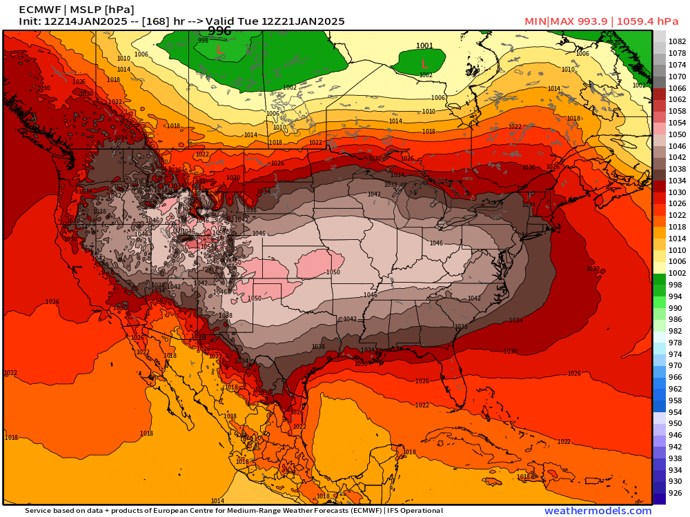
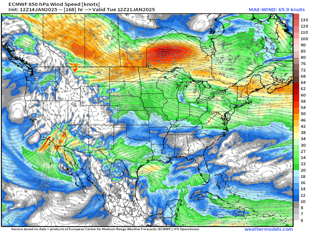
Resulting pressure gradient over the Great Basin at elevation and the Pacific means risk for extreme Santa Ana Winds
The tropospheric polar vortex is extended like a tear drop directly from the North Pole with unimpeded advection of cold/dry air into the Lower 48.
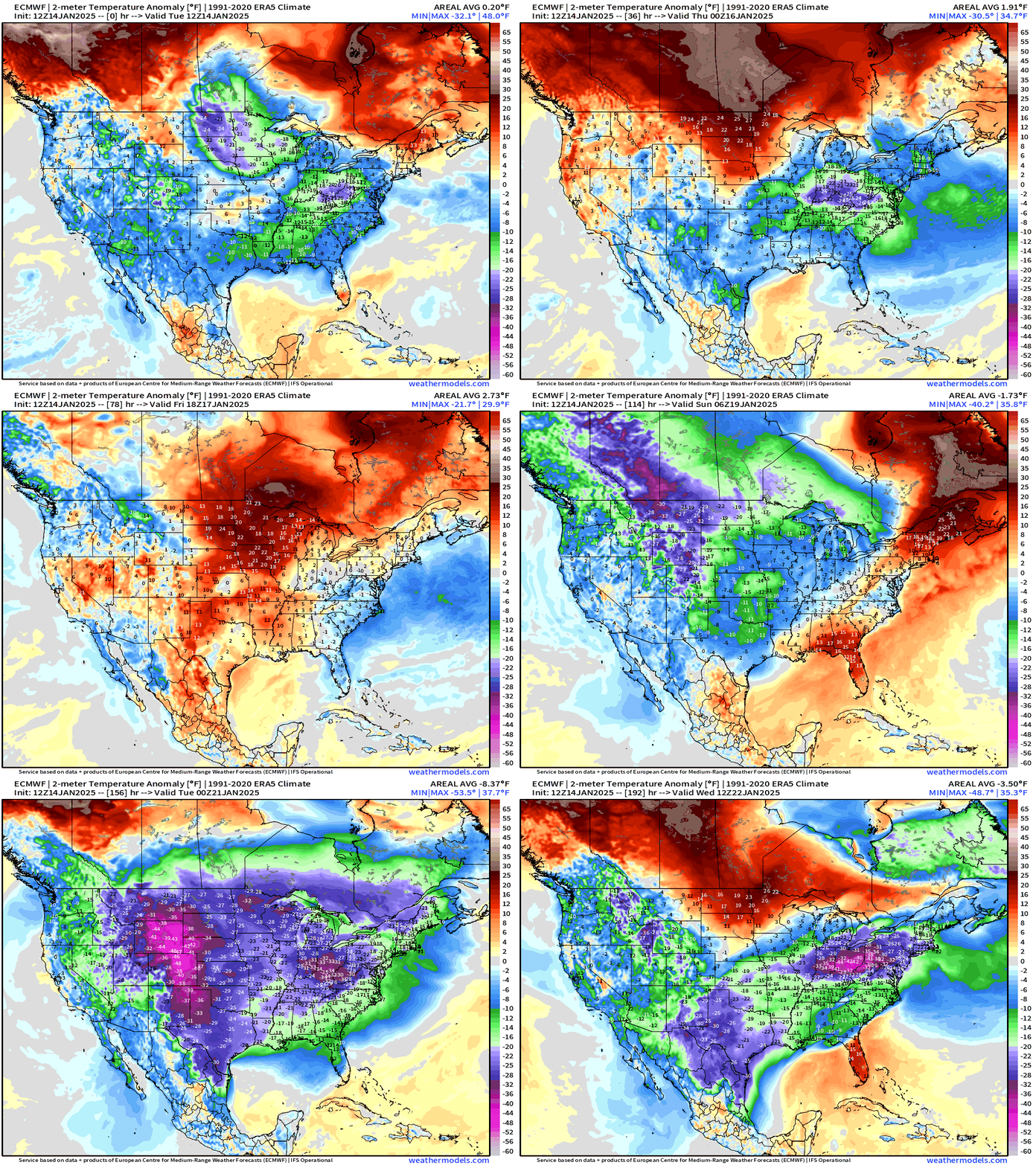
8-day Temperature Anomaly
All of this gets started this weekend, and then it’s rapidly downhill with widespread extreme negative temperature anomalies across the Rockies, into Texas, and then into the Midwest/Ohio River Valley.
Lake Effect Snowfall Continues
Next 10-days from ECMWF AIFS 12z
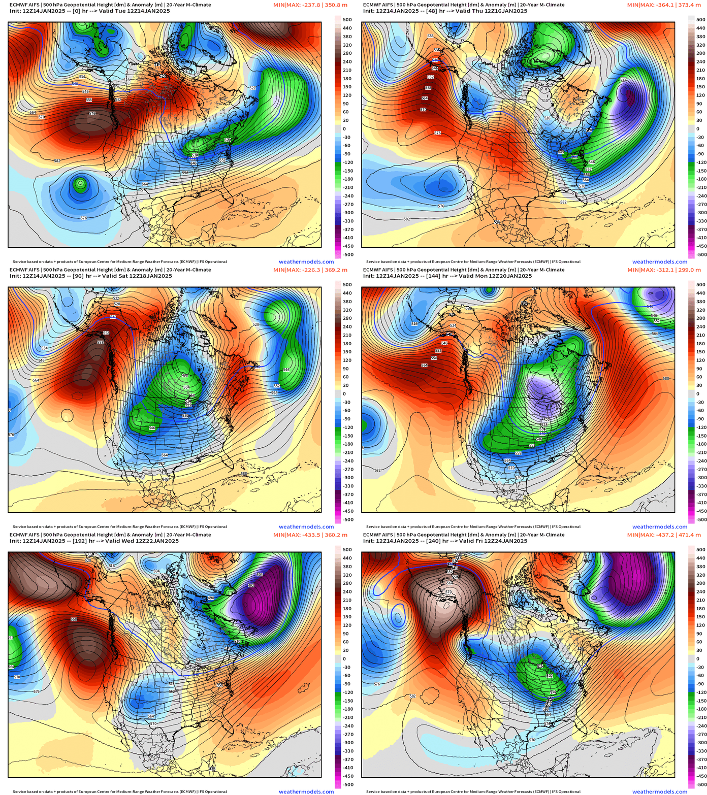
The key to the extremes across far southern locations like Texas is the ability of the trough to break into the U.S. Southwest through the Rossby wave breaking / trough thinning process. The ensemble means will not help you resolve this!
The weakly cyclonic circulations around these cut-offs serve to direct moisture out of the subtropics into the Gulf Coast states up/over the Arctic cold pool = disaster.
Precipitation Type and MSLP Next 10-days
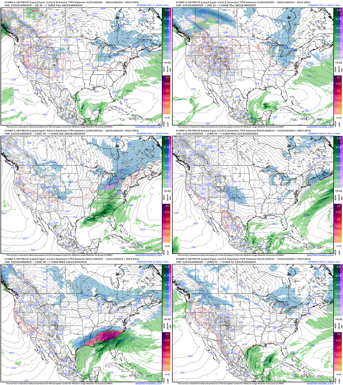
And, holy moly, the ECMWF 12z (as well as GFS 12z, but I’m not wasting your time) shows a winter weather debacle from Houston to Atlanta with heavy freezing rain and snow. HOWEVER, this wasn’t in the 00z forecast cycle, so we don’t have to run to Costco right away. The likelihood of such a scenario is against climatology, and dependent upon a lot of moving parts that I explained earlier. A more aggressive ridge from the Pacific would reduce the southward extension of the Polar Vortex into Texas, and probably keep temperatures warm enough for only rainfall, if precipitation or a storm system formed. I’m at coin-flip, based upon the ensembles.
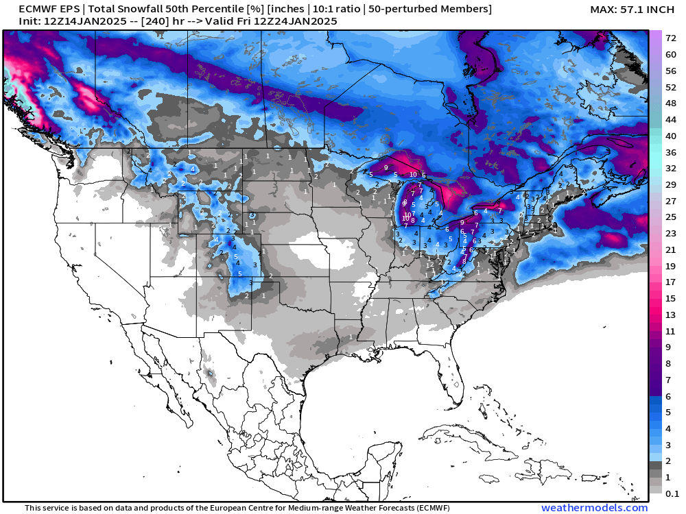
Ensemble Snowfall
The median snowfall is only going to show you a value if more than half of ensemble member (n > 25) have snow. So the signal in the extended range e.g. Day 7-10 would need to be very strong to show up especially in Texas or the Deep South.
If we look at the ensemble mean — higher end amounts carry more weight against the number of zeroes. I don’t know if this makes sense at extended days.
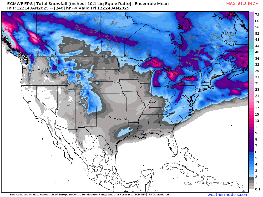
So, as I’ve said all winter, we look at the probabilities.
At least 1-inch of Snowfall through 10-days
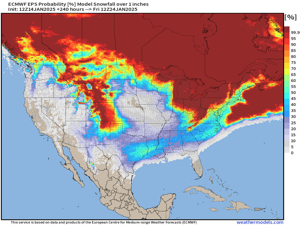
So, we see uncomfortably large snowfall probabilities in Houston and Atlanta.
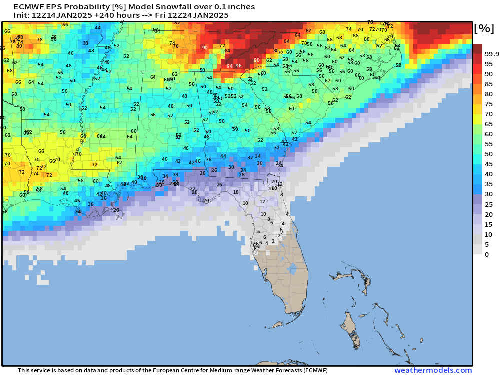
What about any snowfall in Florida?
25% in Tallahassee, 6% in Tampa.
Wednesday Morning Lows
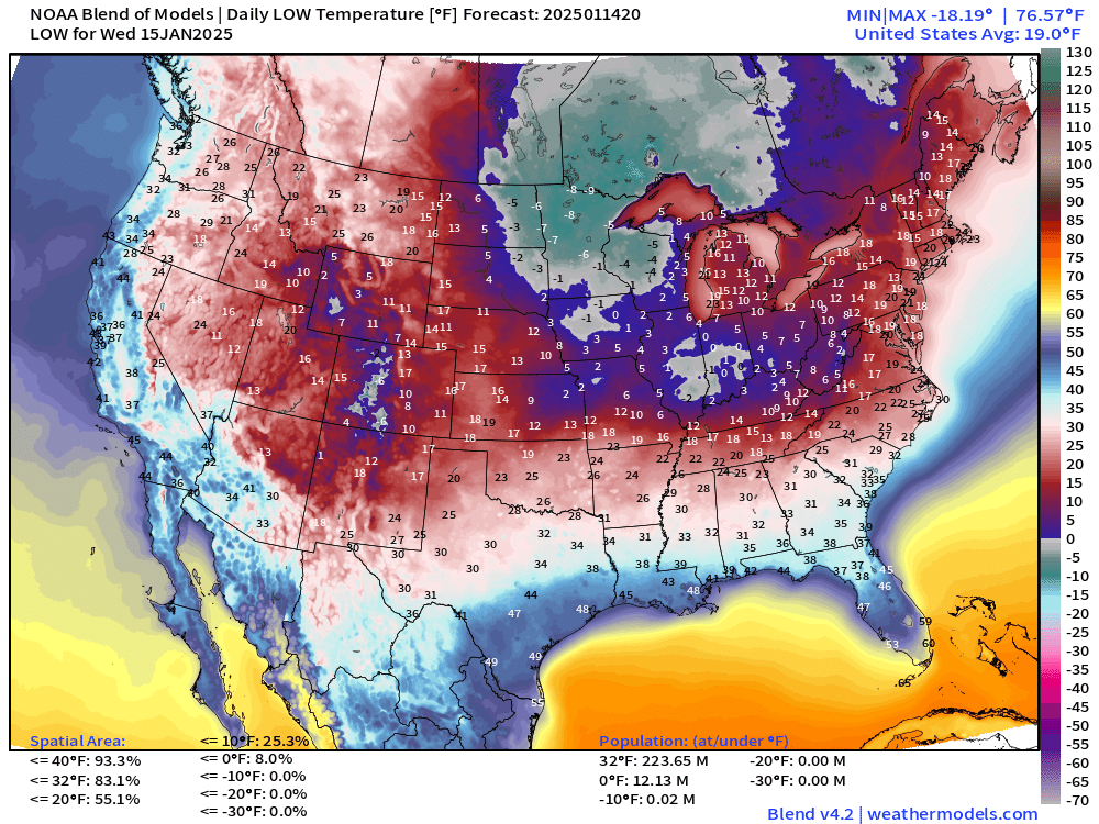
12 million population below zero! And up to 224 million freezing. Lower 48 average is 19°F
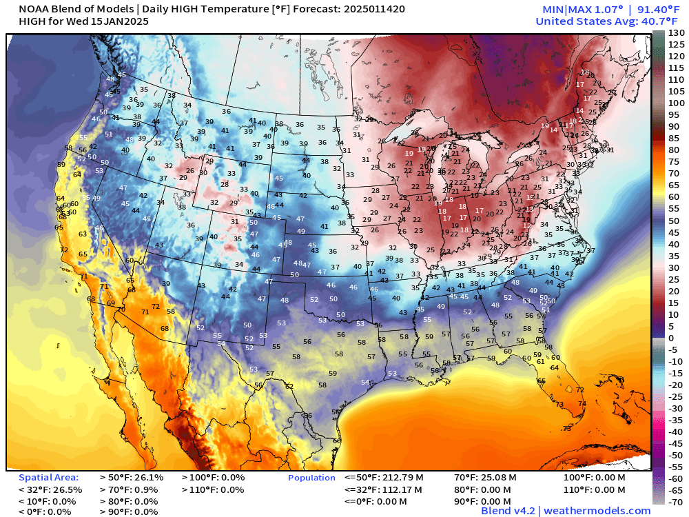
Wednesday Afternoon Highs
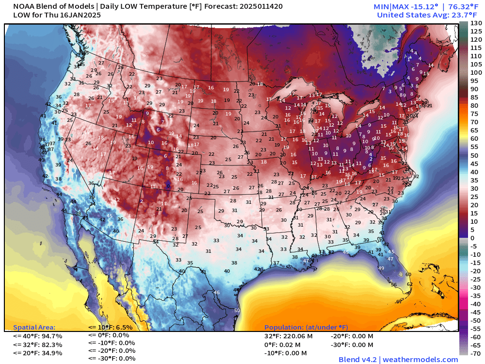
Thursday Morning Lows
Next Monday Lows —> YIKES LOWER 48 average of 7.6°F
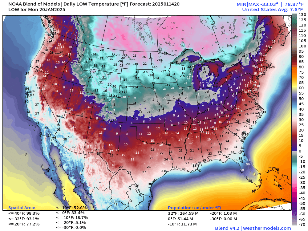
51 million subzero, and 12 million colder than -10°F
The Blend of Models is probably the best indication of most likely temperatures over the next 10-days.
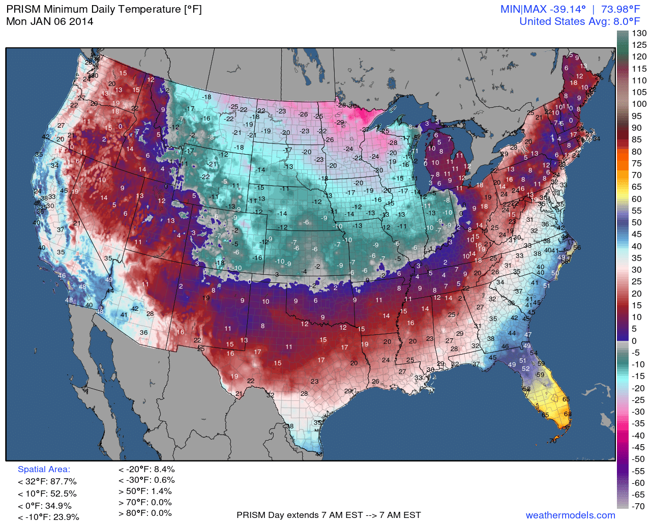
Quick comparison to the first coldest day of the Polar Vortex from January 6-7, 2014. The next day was 5°F.
5:15 PM ET Temperatures across the Lower 48
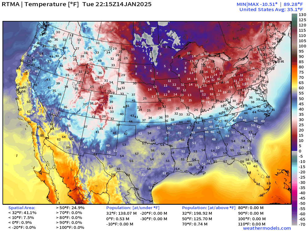
Cold across the Midwest and Great Lakes
Temperature Anomaly | 5:15 PM ET
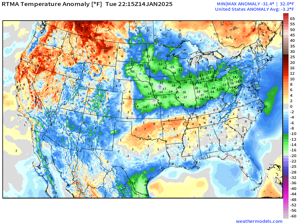
Overall the Lower 48 is -3.2°F (below normal) with coldest centered around Illinois.
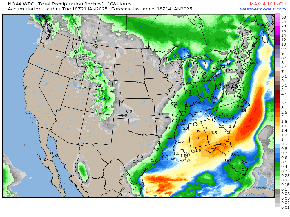
NOAA WPC 7-Day Precipitation
ECMWF EPS 12z | 5-Day Chunk Temperature Anomaly
Days 1-5: January 14 - January 18
Days 6-10: January 19 - January 23
Days 11-15: January 24 - January 28
For new followers coming from Substack, X, or friends, you’ll get daily updates of mainly Lower 48 weather including winter storms, heat waves, hurricanes, and now Arctic blast. The goal is to provide a “heads up” to impending extreme weather in the coming 1-2 weeks — medium range weather prediction. I use the best and most advanced Numerical Weather Prediction (NWP) systems including ECMWF ensembles, NOAA GFS, and the state-of-the-art A.I. systems.
Who writes and researchers this Newsletter? Dr. Ryan N. Maue [X https://x.com/ryanmaue] with 20-years experience of daily weather model production and analysis. You may have seen my weather maps! I live in Atlanta but was born and raised in Northern Michigan. I know snow, and southern heat and humidity.
Maps sourced from weathermodels.com designed and innovated by yours truly! Please subscribe there for real-time access to the newest maps, charts from all of the weather models including ECMWF.
- Milepost
- 495 · laid 2025-01-14T23:01:18.386000Z
- Source
- https://weather.substack.com/p/january-14-2025-severe-arctic-blast
- Digest
- f1a91f2fedff7d58e36aea31af0a900fb17189dd05139dbe5b17dc688328bfa8
- Machine
- JSON