December 28, 2024 Saturday Winter Weather
Increasing risk for historic cold by January 8-11
December 2024 was the 4th-warmest December in the 131-year national record (1895–2025), at 38.1°F against a 1991–2020 normal of 34.3°F (+3.8°F).
December 2024 was the 64th-driest December in the 131-year national record (1895–2025), at 2.4in against a 1991–2020 normal of 2.5in (-0.1in).
NOAA/NCEI Climate at a Glance, contiguous United States. This is the observed record for the month, not a score of anything said in this piece — the forecast ledger begins 2026-08-17 and cannot reach earlier posts.

Saturday Morning Update: Good morning!
8:45 AM ET Temperatures across the Lower 48
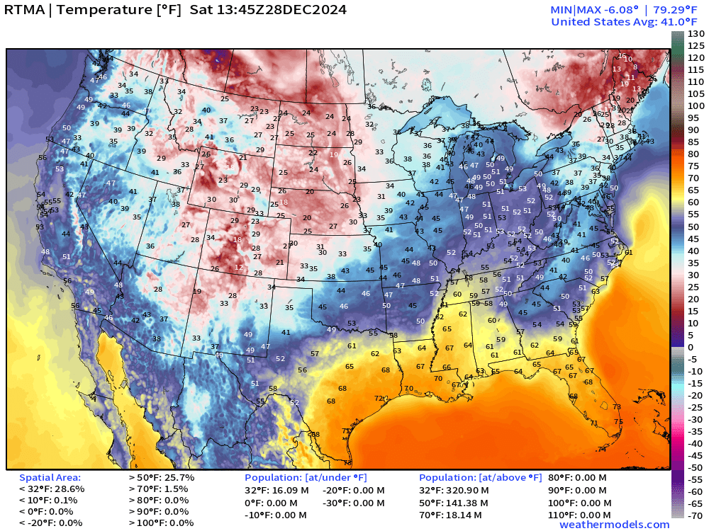
Maine is holding onto the coldest temperatures across the Lower 48 this morning. Notably for me in Atlanta, the mountain cold-wedge remains in place with stubborn clouds and mist.
Temperature Anomaly | 8:45 AM ET
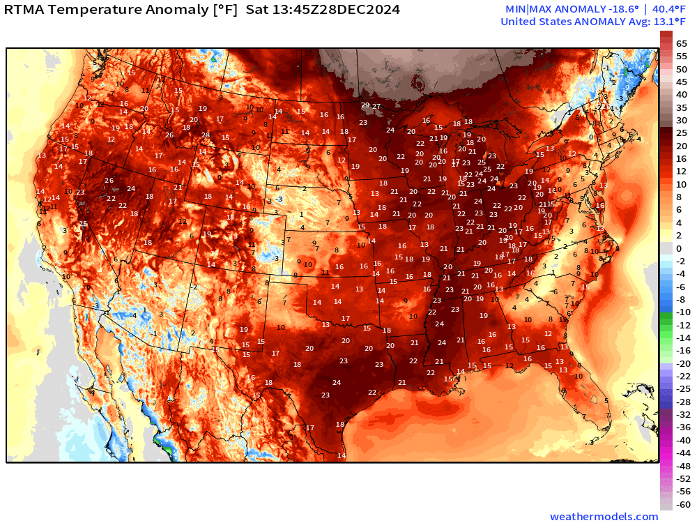
Overall the Lower 48 is a whopping +13.1°F (above normal)
Saturday High Temperatures
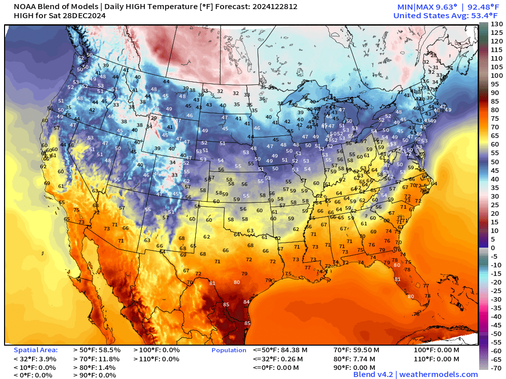
Into the 60s in the Ohio River Valley, also Nashville and Pittsburgh
Sunday Low Temperatures
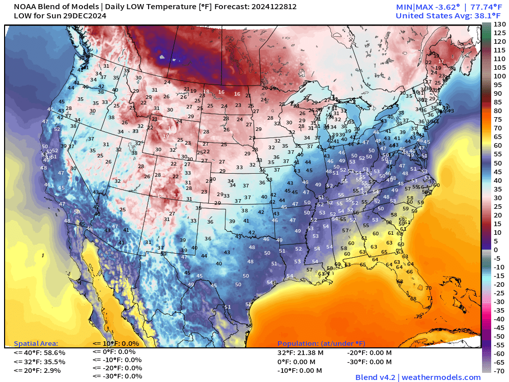
Very warm overnight across the East Central Lower 48.
Sunday High Temperatures
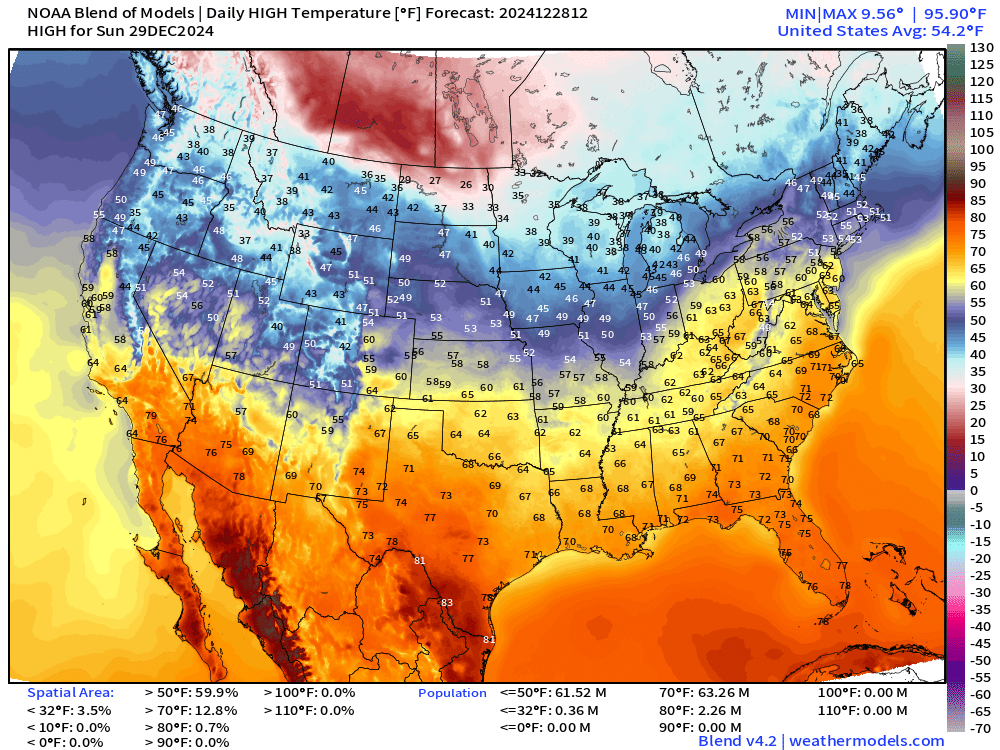
Even warmer on Sunday with 60s pushing into Philadelphia. 70s into the Carolinas. 63 Million at/above 70°F for December 29 is quite a end of 2024 treat.
Weather Headlines for Saturday
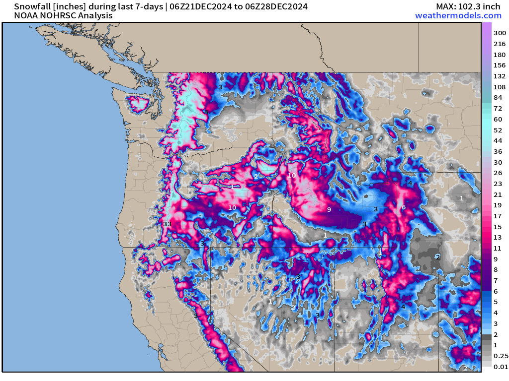
Pacific Northwest storm systems and atmospheric rivers — broken record. The mountain snows continue to pile up even with the warmer than normal temperatures.
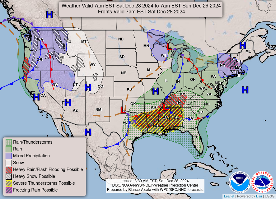
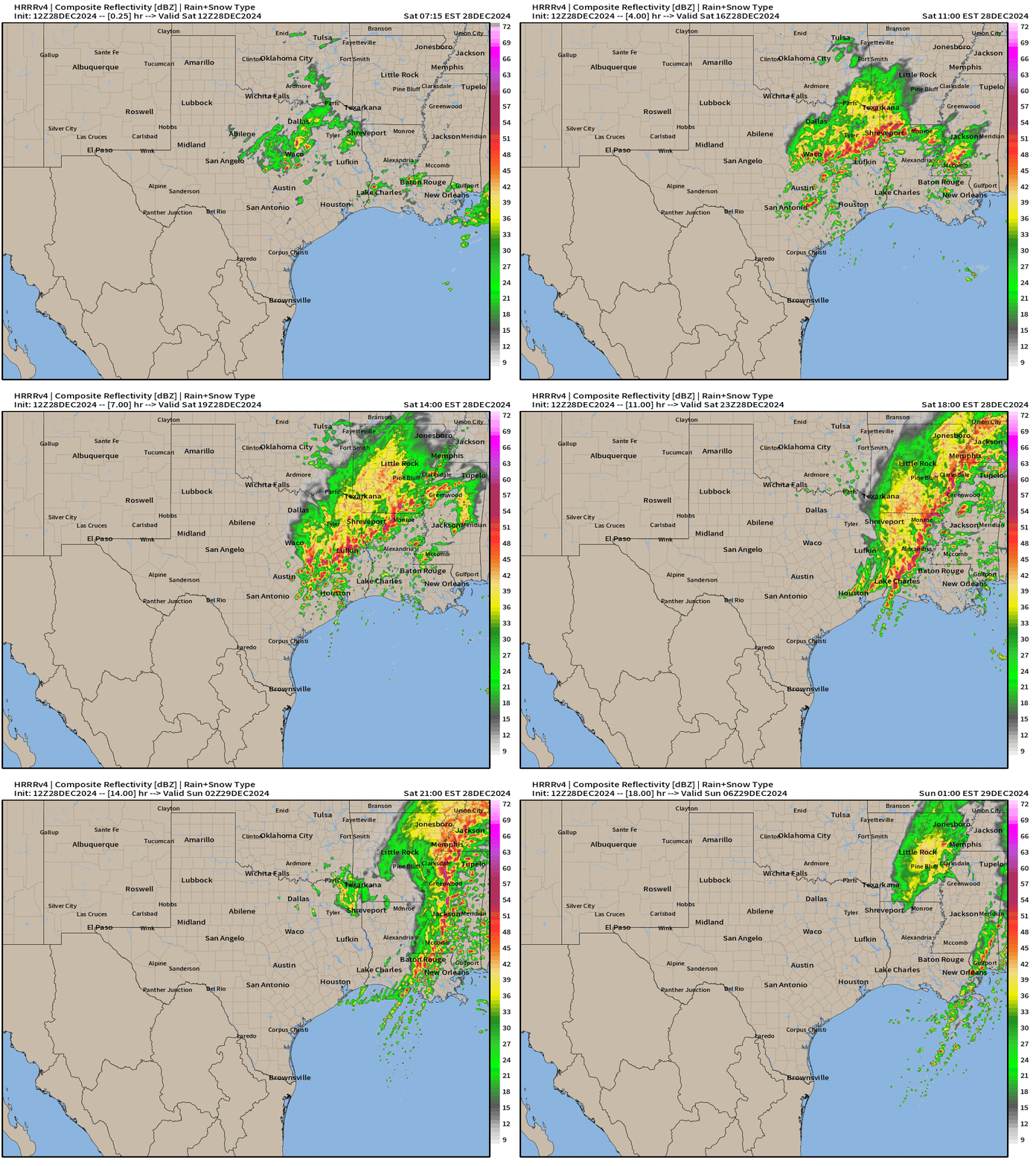
Powerful storm system developing out of Texas across the Deep South will fuel severe thunderstorms through late Saturday. SPC has a moderate risk including the risk of EF2 tornadoes!
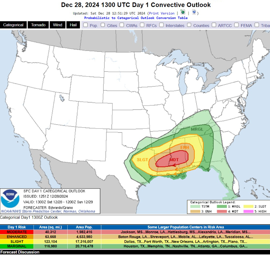
...SUMMARY...
Tornadoes (some strong with at least EF2 damage possible), severe gusts and hail are expected today into tonight. The threat area will shift eastward from parts of north and central Texas early, across east Texas and the lower Mississippi Valley today, then over the Tennessee Valley, parts of Georgia, and the central Gulf Coast tonight.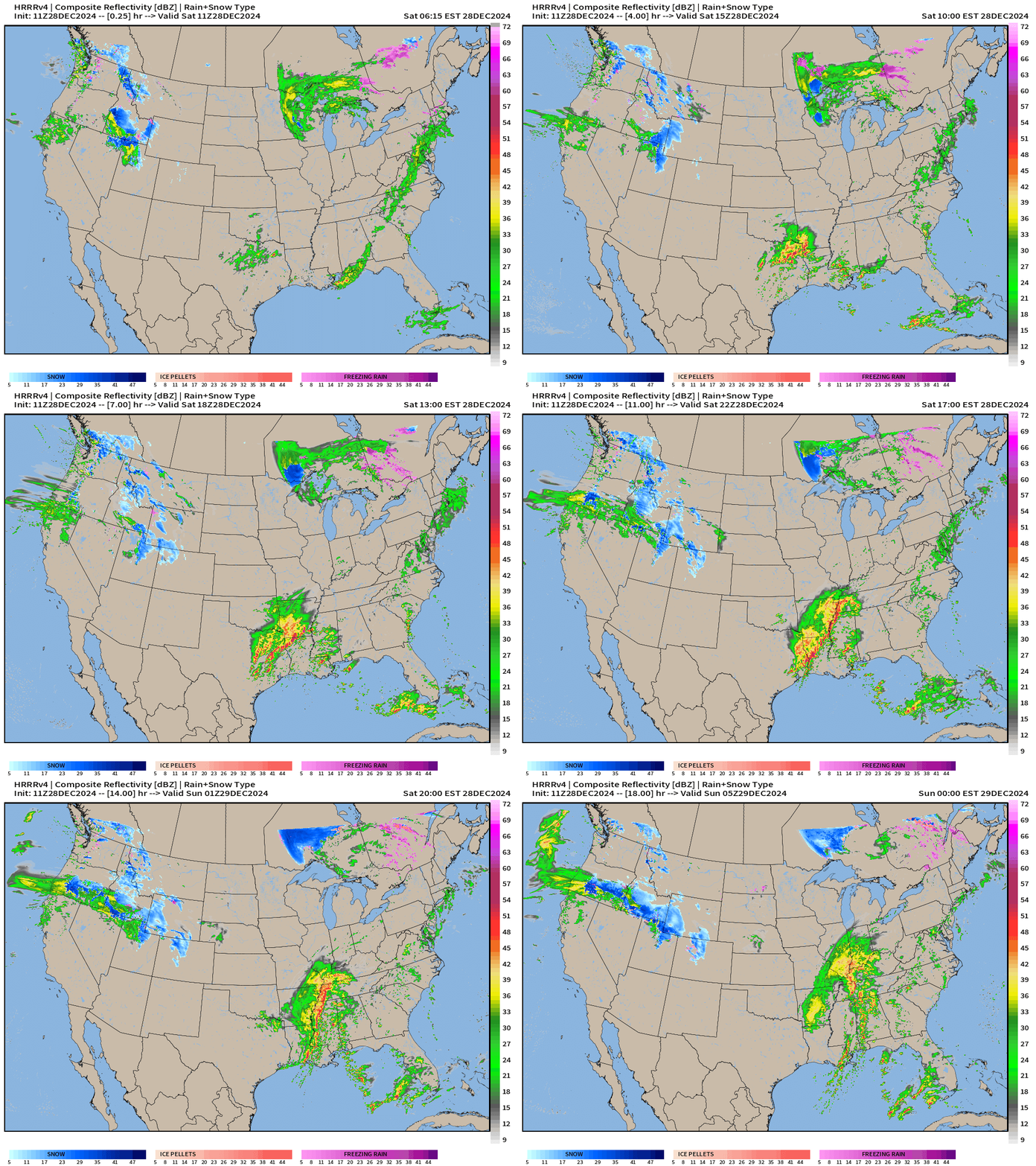
HRRR Simulated Radar Next 18-hours through Midnight Zoom into Texas/Louisiana
Threat for tornadoes across Louisiana into afternoon/evening.
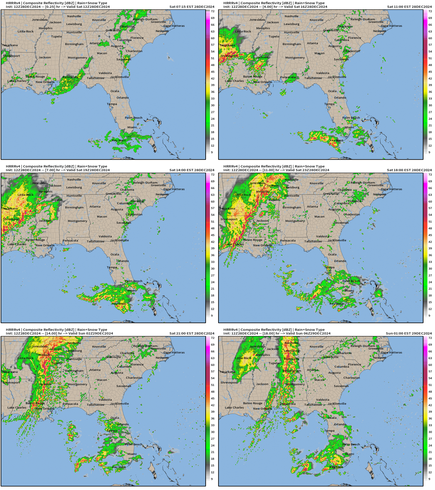
Zoom into Southeast
Storms track into Alabama by Midnight as a likely still severe squall line.
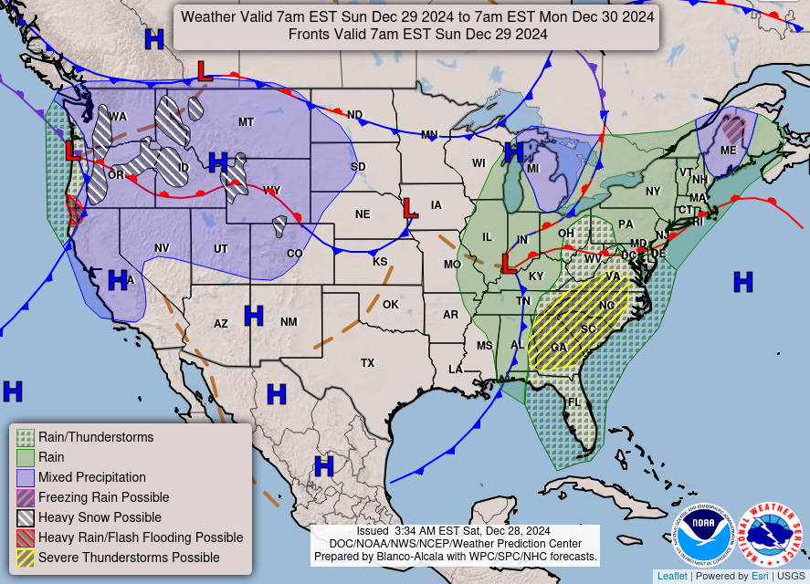
Weather on Sunday
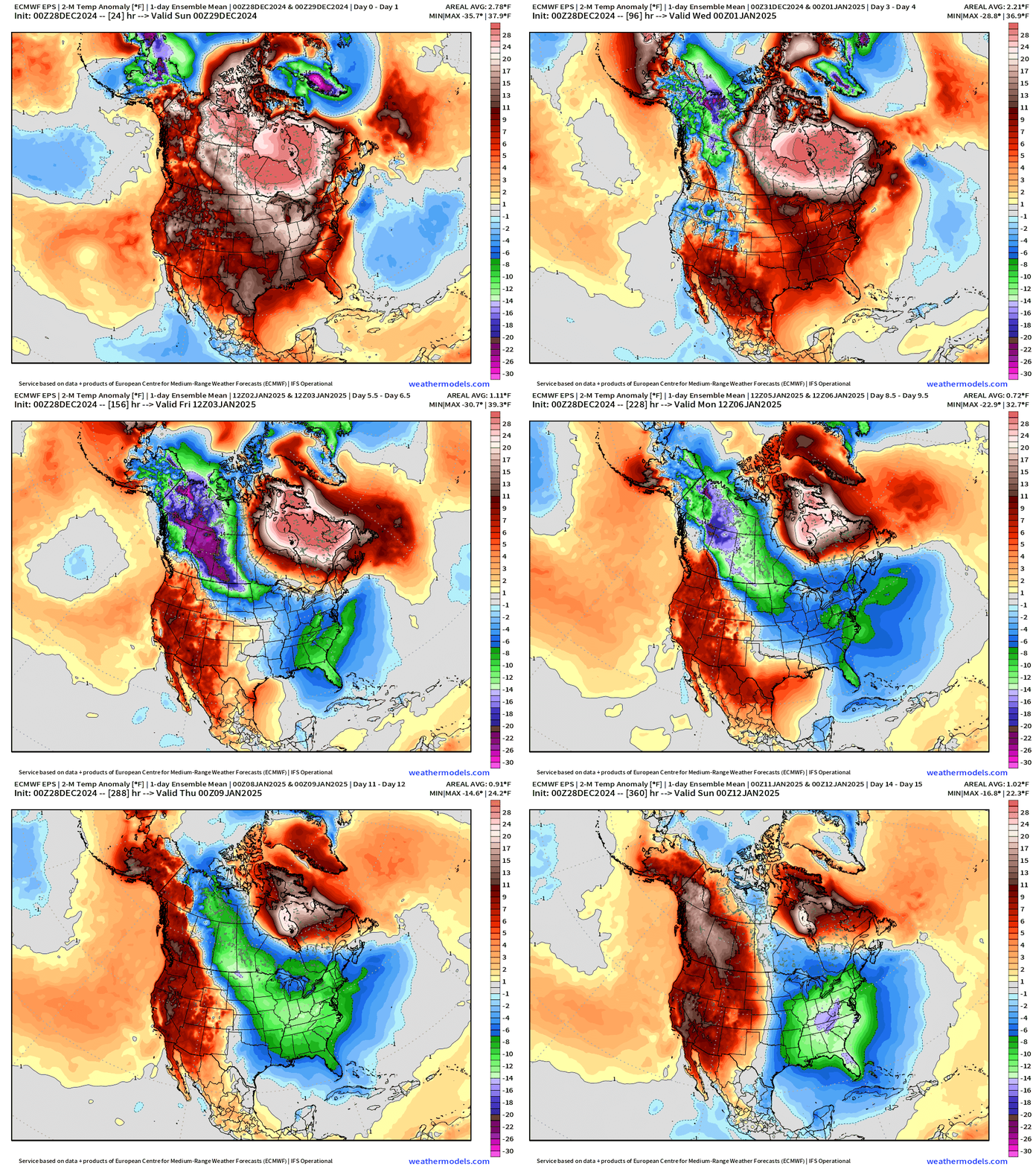
Major pattern change to begin January 2025! Temperature anomaly by January 2-3 will significantly turn negative (next Fri/Sat) with the first wave of colder Canadian continental air on the backside a Northeast storm system. Models continue to trend MUCH colder into Jan 8-10 with a “main event” polar vortex “Arctic blast” that aligns the large-scale circulation from the troposphere into the stratosphere (usually anchored over Hudson Bay or northern Arctic Canada). Temperature Anomaly (Ensemble Mean) next 15-days:
ECMWF 00z precipitation type and MSLP next 7-days
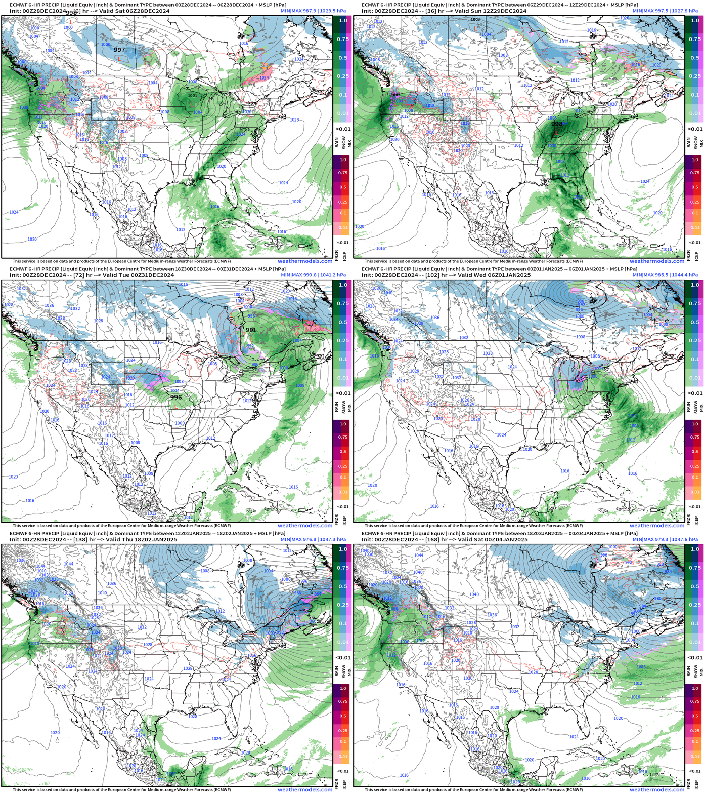
Heavy rain across South into the Ohio Valley from powerful storm system currently developing across Texas/Louisiana, which will track into Quebec by Monday.
Another area of Low Pressure tracks through the Plains into Ohio by next Wed/Thurs, and intensify over Quebec (again) with some snow on the backside in the much colder air.
The first polar front in a while arrives for Jan 2-3 for the Eastern U.S. as high pressure builds across the Midwest — and back in Canada setting the stage for the “main event” the following week.
NWS | Total Precipitation Next 48-hours
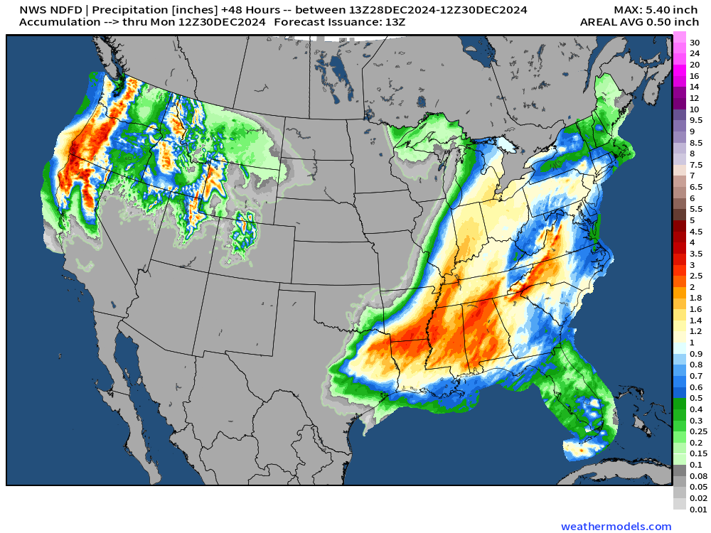
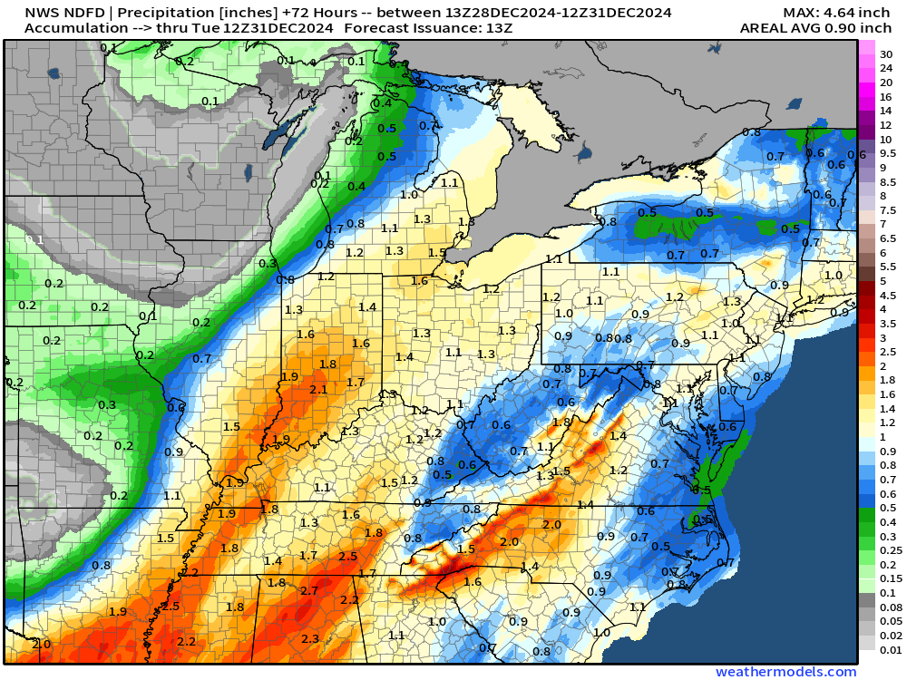
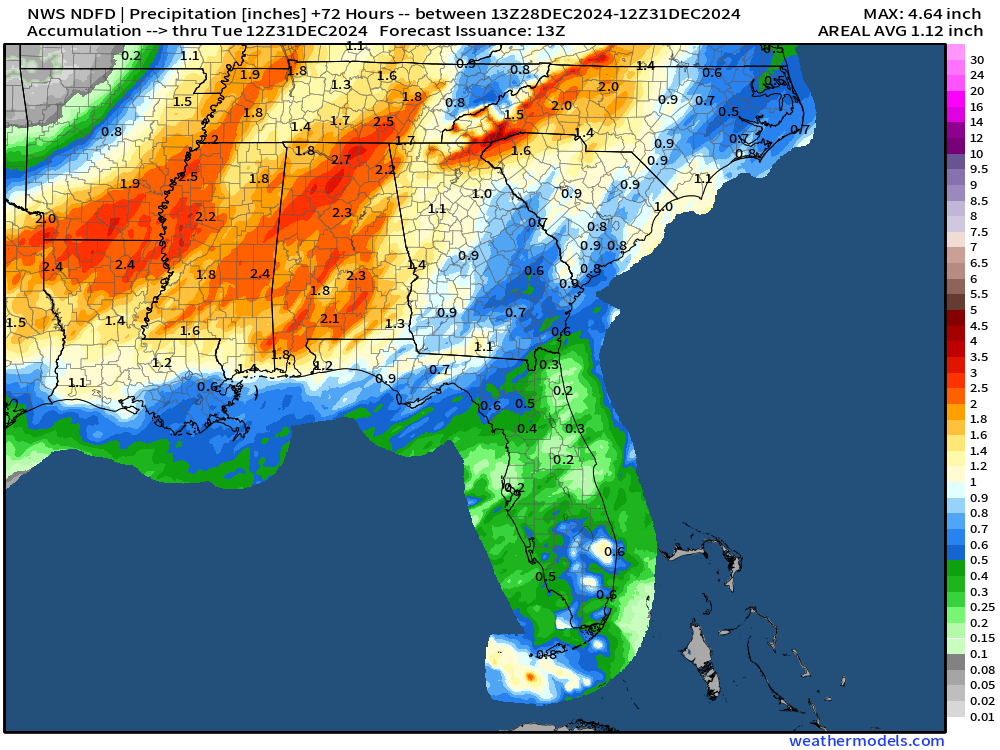
Large area of 2-inches+ rainfall from Louisiana into the Southeast including Atlanta and the Carolinas, and into the Mid-Atlantic.
2-day totals of precipitation in the 2” to 4” range across northern California into the Cascades where higher elevations will see enormous snowfall.
NWS | Total Snowfall Next 72-hours
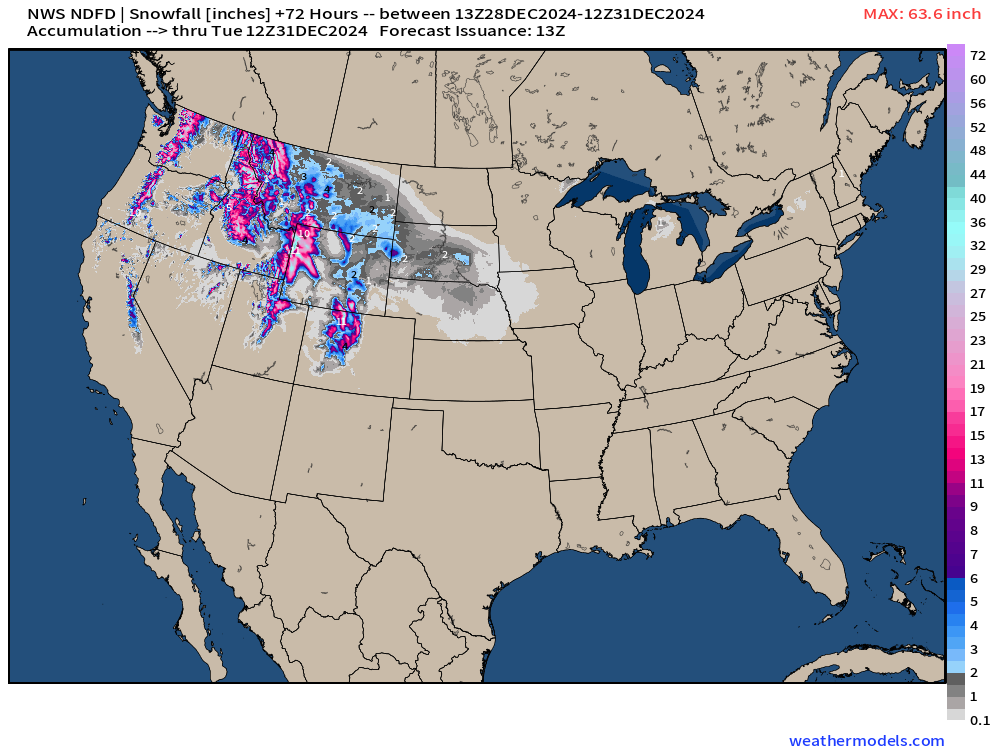
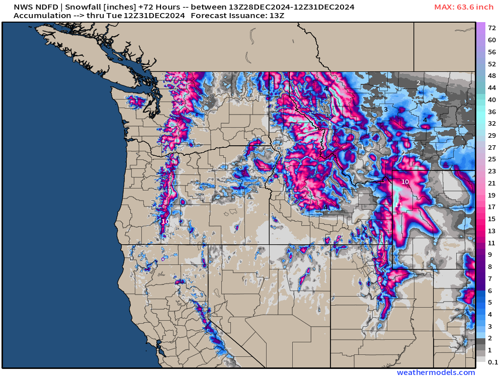
While the storm systems are relatively warm with Pacific moisture from subtropical origin atmospheric rivers, the air mass is cold enough at elevation to see many feet of snowfall.
Total Precipitation next 7-Days | NOAA WPC
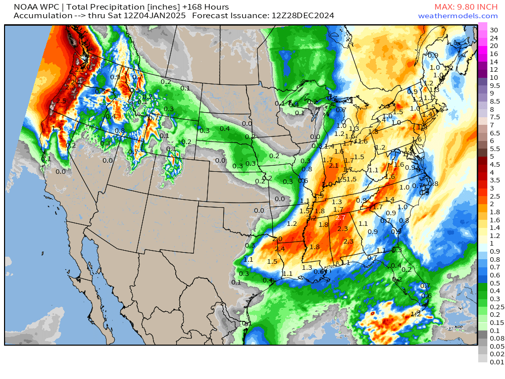
Very wet pattern for Eastern U.S. for late December. Boatloads for Pacific Northwest.
ECMWF 00z Extreme Forecast Outcome
We need to talk about the updated ECMWF forecast from 00z through the next 2-weeks.
This is the “control run” or unperturbed ensemble member, but it is only 1 solution out of 51. However, that doesn’t mean it has a 2% likelihood of happening in reality. We need to look for agreement from the other ensemble members in a time window of 24-48 hours to account for spatial / temporal spread in the total ensemble.
However, the ensemble also provides valuable information about “tail risks” in the extended range. We can watch as the forecast date arrives if extreme solutions are becoming more/less likely. Suffice to say, this is a historical outcome that would not be pretty for the Southeast U.S.
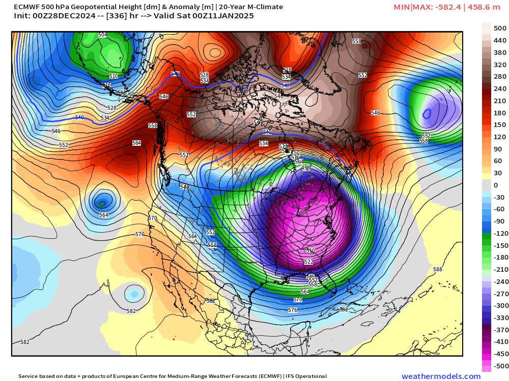
A large cyclonic gyre encompasses eastern North America with the polar vortex anchored far to the south over Ontario. This is the “whole load” and displacement of the typical TPV located over Hudson Bay or near Greenland.
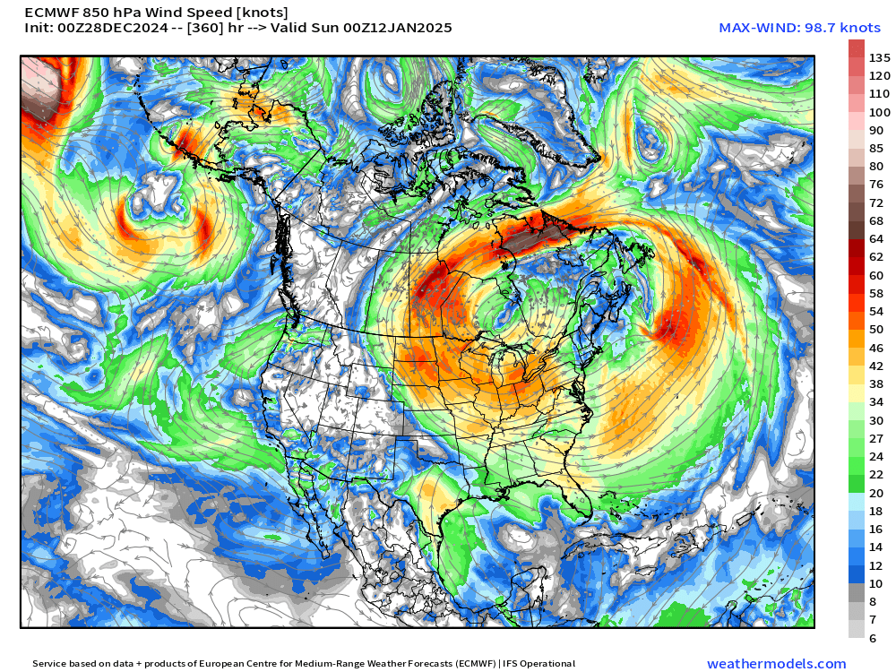
Height Anomaly is extreme with 540 dm heights into North Florida.
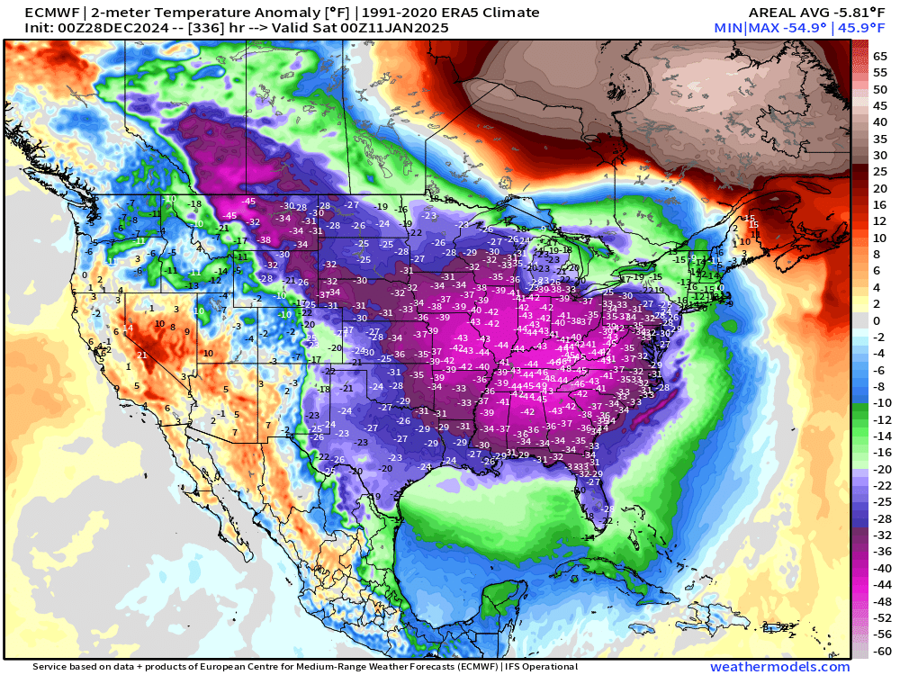
And temperature anomaly of 45°F below normal for already cold January 10-11 across the Eastern U.S.
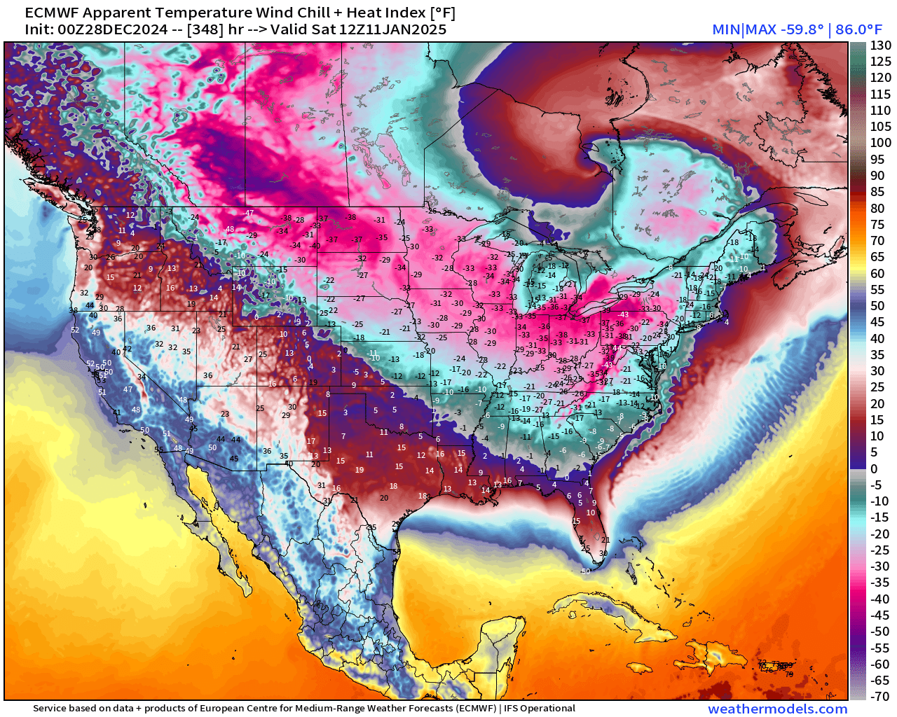
Wind chill temperatures would be dangerous into South Florida.
HOWEVER
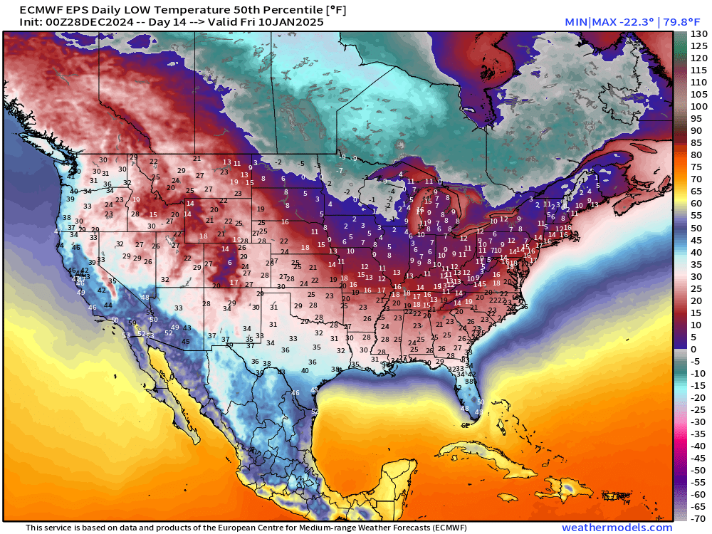
And, this is where the valuable context comes into play. The median ensemble solution for the eastern U.S. is cold, but not historic. Instead, a low of 21°F would be rather seasonable in Atlanta.
But will the median outcome be the most likely forecast at Day 14? That’s where more tools need to come into play with other models, cluster analysis, and expert analysis!
EPS and GEFS Ensemble Mean 00z | Day 13
It seems the pattern shift to Arctic blast by January 8-11 is baked in the cake.
Over the next week, we must assess the risk of extreme outcomes.
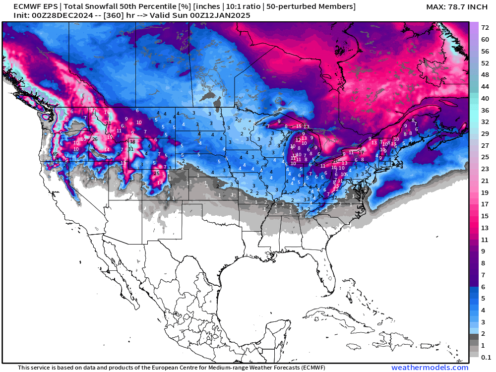
15-Days Ensemble Median Snowfall
Interesting to see 0.1” of snowfall showing up in North Georgia on the “median” accumulation map through 15-days. Significant Lake Effect + western Mountain snowpack building!
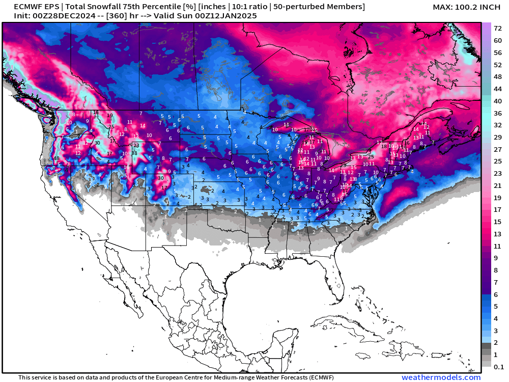
75th Percentile Solution Through 15-days
This can be read as there is a 25% chance of at least 2” of snowfall in Atlanta.
Most Extreme Solution Through 15-days
Based upon the 00z ensembles (51-members) this would be most snowfall at any location with a 2% chance of happening [1-member] …
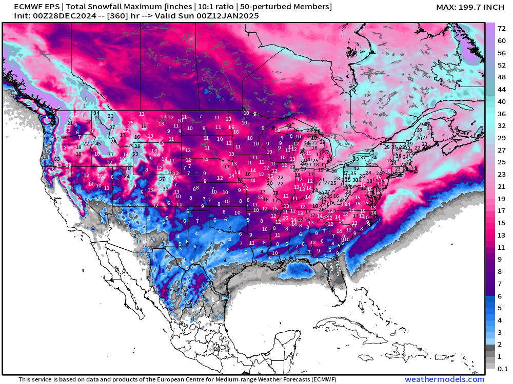
What does this mean? Even in the climate of January 2025 with “global warmth” we can still see 2” of snowfall in Orlando assuming the most extreme upper-level “polar vortex” displacement.
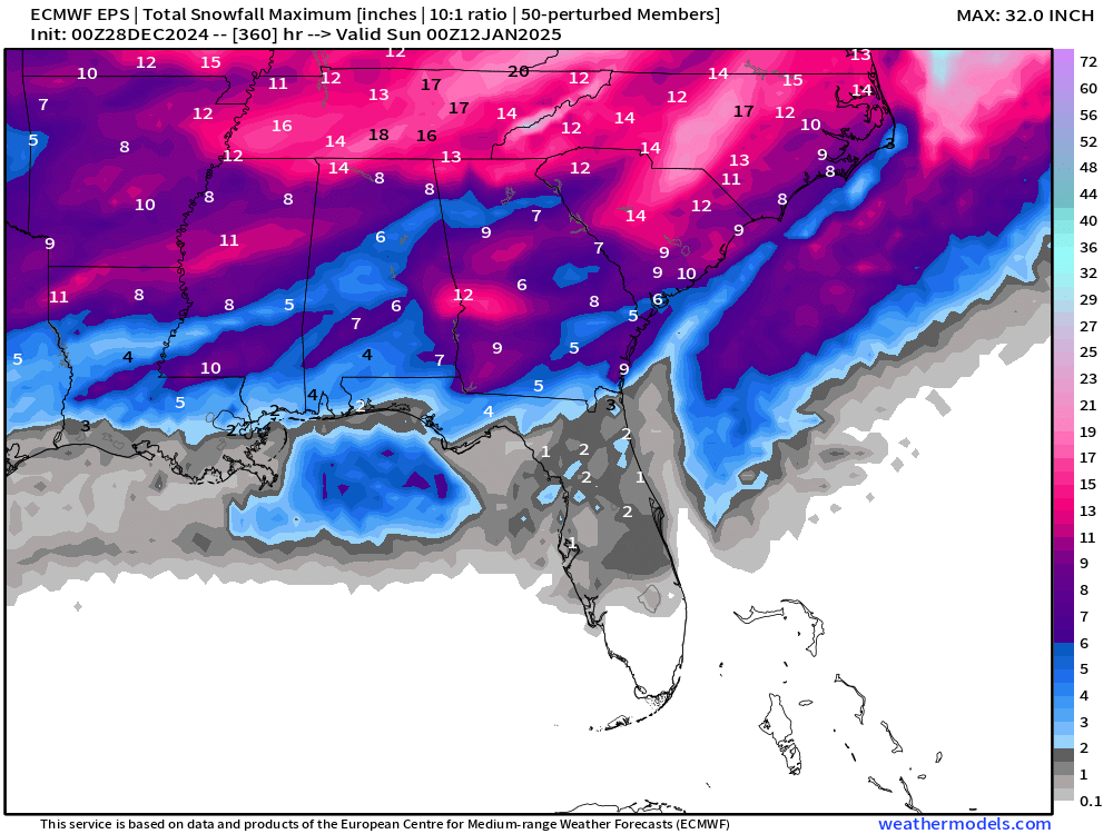
Probability of 0.1”+ Snowfall Next 15-days
Any snow over the next 15-days?
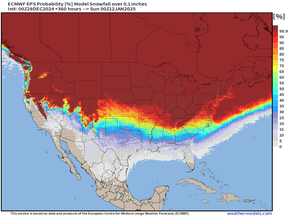
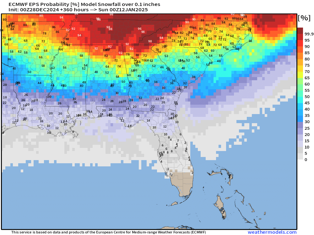
Small chances into Florida — even 2% in Orlando. Better than 60% in Atlanta and the Carolinas.
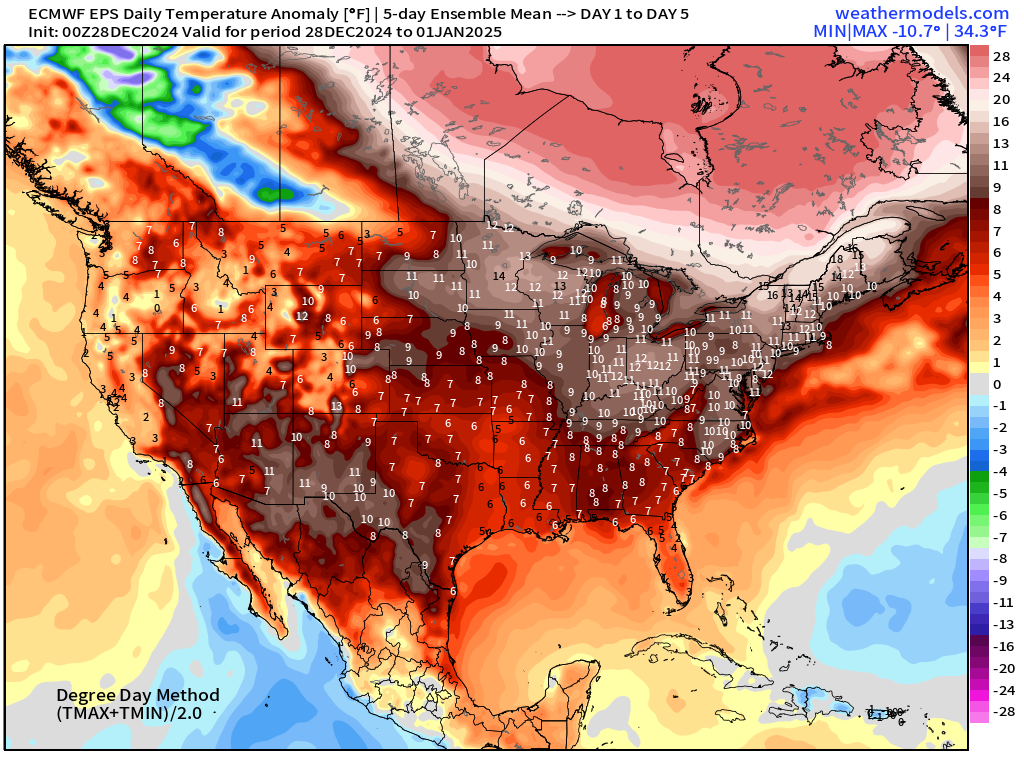
ECMWF EPS 00z | 5-Day Chunk Temperature Anomaly
Days 1-5: December 28 - January 1
Days 6-10: January 2 - January 6
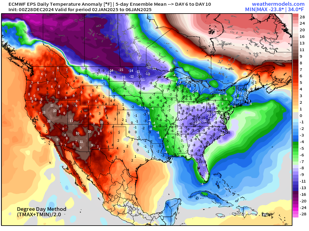
Very cold over Western Canada — poised to dump into the Lower 48 for 2nd week of January.
Days 11-15: January 7 - January 11
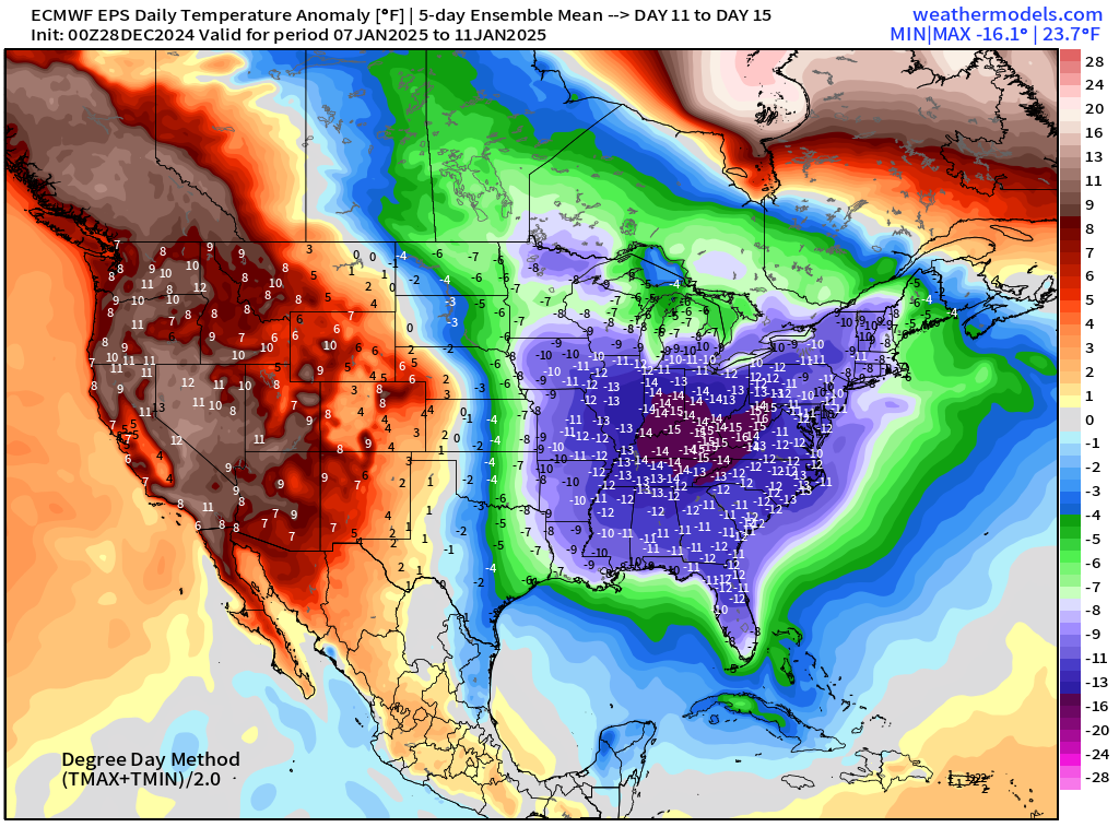
Very significant cold anomaly across Eastern U.S. with [relative] warmth out west.
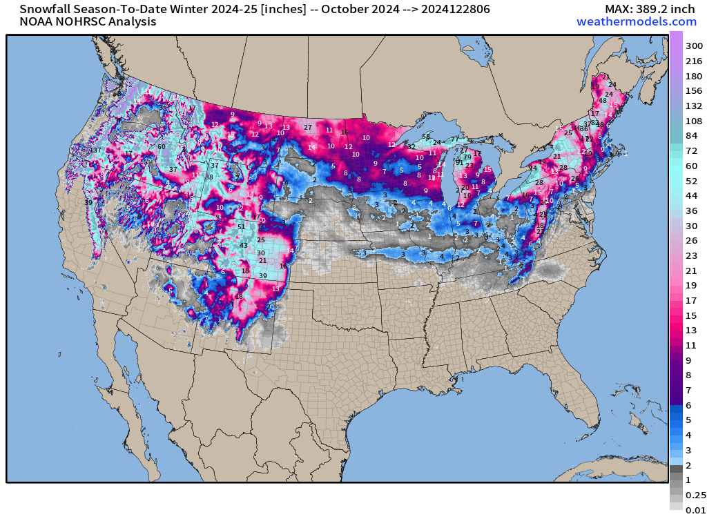
Snowfall Analysis | Season to Date October 1, 2024 — today
Snowfall Last 7-Days
Maps sourced from weathermodels.com designed and innovated by yours truly! Please subscribe there for real-time access to the newest maps, charts from all of the weather models including ECMWF.
- Milepost
- 474 · laid 2024-12-28T14:47:34.342000Z
- Source
- https://weather.substack.com/p/december-28-2024-saturday-winter
- Digest
- 58019d1fd8830dbb2bcee518ecdfb3b0b10856bf764bc46d87949cb37226977e
- Machine
- JSON