June 24, 2020 Tropical Update
Fish storms in Eastern Pacific as dust envelopes Caribbean and Gulf of Mexico
June 2020 was the 29th-warmest June in the 132-year national record (1895–2026), at 70.3°F against a 1991–2020 normal of 69.5°F (+0.8°F).
June 2020 was the 40th-driest June in the 132-year national record (1895–2026), at 2.7in against a 1991–2020 normal of 3.1in (-0.4in).
NOAA/NCEI Climate at a Glance, contiguous United States. This is the observed record for the month, not a score of anything said in this piece — the forecast ledger begins 2026-08-17 and cannot reach earlier posts.
Since the Atlantic is quiet except for the non-stop coverage of a historical Saharan dust outbreak, I figure it’s a good idea to look at the Eastern Pacific (EPAC) where many hurricanes occur every season harmlessly.
Tropical Depression 03E

The EPAC has only seen Tropical Storm Amanda and one other tropical depression unusual through almost the end of June. Of course, when you say an “average season” in the EPAC or North Atlantic, you are not being very informative since the two basins are anti-correlated with feast or famine — and have been so since the early 1980s according to published research. When there is an ongoing strong El Nino, there are often many large hurricanes in the EPAC — Hurricane Linda comes to mind in 1997 because I remember watching that one on the Weather Channel Tropical Update. It was a Category 5 monster well off the coast of Mexico. This satellite image is from Sept 12, 1997.

How did Linda become so intense — 185 mph winds?
Very warm sea-surface temperatures. An extensive pool of > 29°C SST for Category 5 almost to 120°W longitude and warmth up the western coast of Baja California. There’s always some clickbait story about a storm reaching southern California and this is the type of strong El Nino you would need for a storm to survive long enough to reach San Diego’s latitude. Reminder, it is the “actual temperature” of the sea-surface that helps fuel a hurricane not a temperature anomaly. An anomaly is just a statistical construction that helps put an event into climatological context.
SST on September 10, 1997

Another year that had a super El Nino was 2015 and take a look at the warm water pool all the way west past Hawaii. This opens up the entire Central Pacific for very powerful hurricanes to track from Mexico all the way to Japan if they got onto the right track.
SST on September 10, 2015

So, what about the water temperatures this week in June 2020 when we are on a La Nina watch?
SST on June 23, 2020
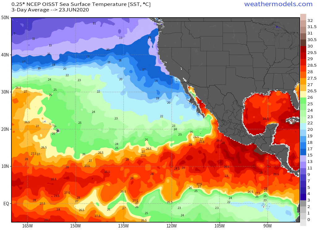
The band of warm water > 26°C is severely constrained with only 10-12° of latitude lane available for tropical storm development. That means there is significantly less real estate for a storm to pass over warm water especially if it has a northerly component of motion. The cool water < 22°C is upwelled off the coast of Peru. Amazing ocean dynamics going on right now and we are waiting for the atmosphere to respond.
7-day Forecast in Eastern Pacific — Storm Tracks

The storm tracks from the EPS 12z show 2 areas of concern — one being TD 03E and another area off the coast of Mexico that is likely to become the season’s first hurricane.
I’m watching the new GFS v16 parallel model runs at https://weathermodels.com (in the lab) for how hurricanes are handled. Coincidentally, ECMWF upgrades their global model on June 30th. More on the model upgrade tomorrow.
- Milepost
- 29 · laid 2020-06-24T23:32:48.838000Z
- Source
- https://weather.substack.com/p/june-24-2020-tropical-update
- Digest
- 1e84fd9b2985a1638fe3222650db9e843ae77de4161a35bad084718503226c61
- Machine
- JSON