March 20, 2024 Evening Update
Afternoon models continue to pile up the snowfall in Midwest + South Florida deluge
March 2024 was the 21st-warmest March in the 132-year national record (1895–2026), at 44.9°F against a 1991–2020 normal of 43.6°F (+1.4°F).
March 2024 was the 29th-wettest March in the 132-year national record (1895–2026), at 2.9in against a 1991–2020 normal of 2.5in (+0.4in).
NOAA/NCEI Climate at a Glance, contiguous United States. This is the observed record for the month, not a score of anything said in this piece — the forecast ledger begins 2026-08-17 and cannot reach earlier posts.

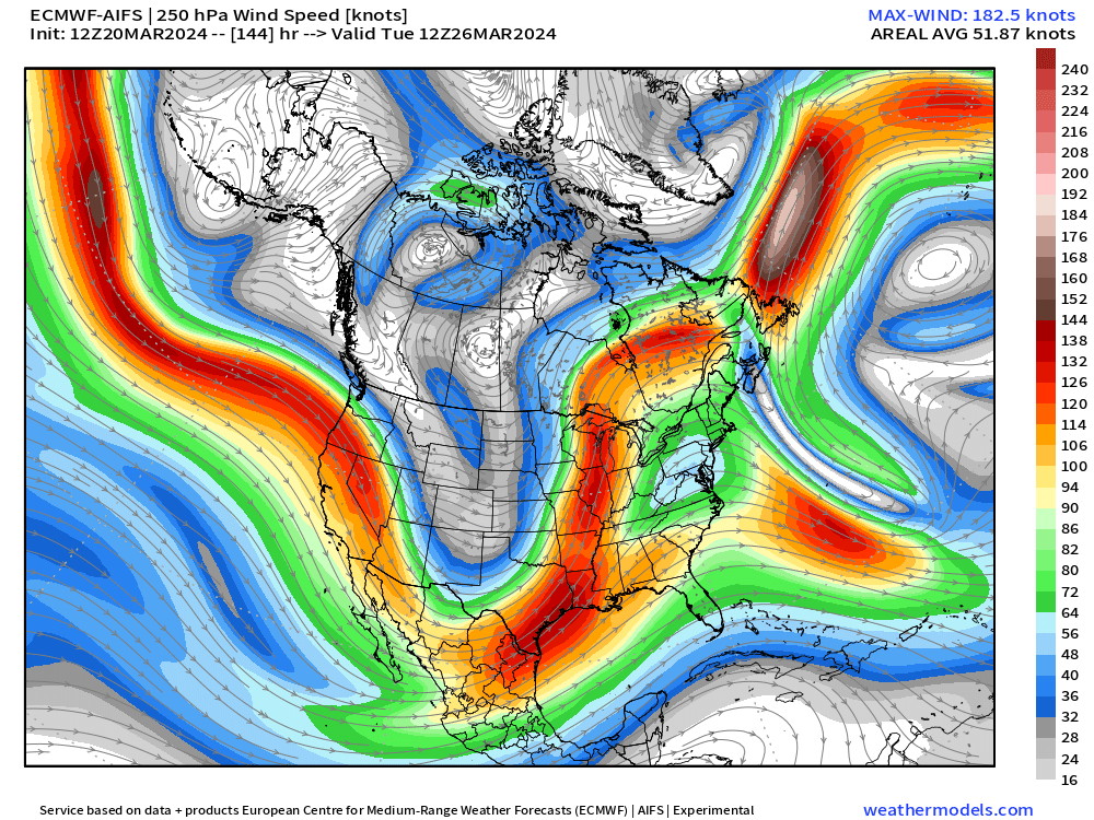
Quick update on the A.I. front as ECMWF has finally finished its provision of AIFS data with u and v wind on pressure levels. I was curious to see what the wind speed looked like especially at the jet stream level. Does it look sharp with extremes like a global model like IFS, or more smooth like ensembles. Glad to see from this example at +6 days from the 12z inference (forecast = inference in A.I. parlance) jet streaks > 180 knots and realistic intensity. As AIFS scores highly in skill comparisons with IFS, I am optimistic about the future developments of this system: ensembles are coming soon.
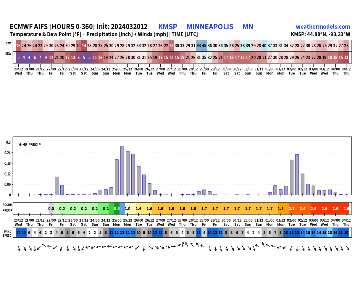
Since we’re looking at AIFS, I though I’d show the meteogram of Minneapolis for the next 15-days. We don’t get precipitation type or snowfall, so we’ll just have to do some math at around 10:1 to calculate the snowfall from 2.5” of QPF likely at cold enough 2-meter temperatures for all-snow = 2-feet of snowfall. And, that matches well the Blend of Models consensus solution (see below).
This forecast goes until April 4 — no sign of Spring in the Midwest for at least another 2-weeks!
Mild Wednesday Afternoon for ~100 Million Americans
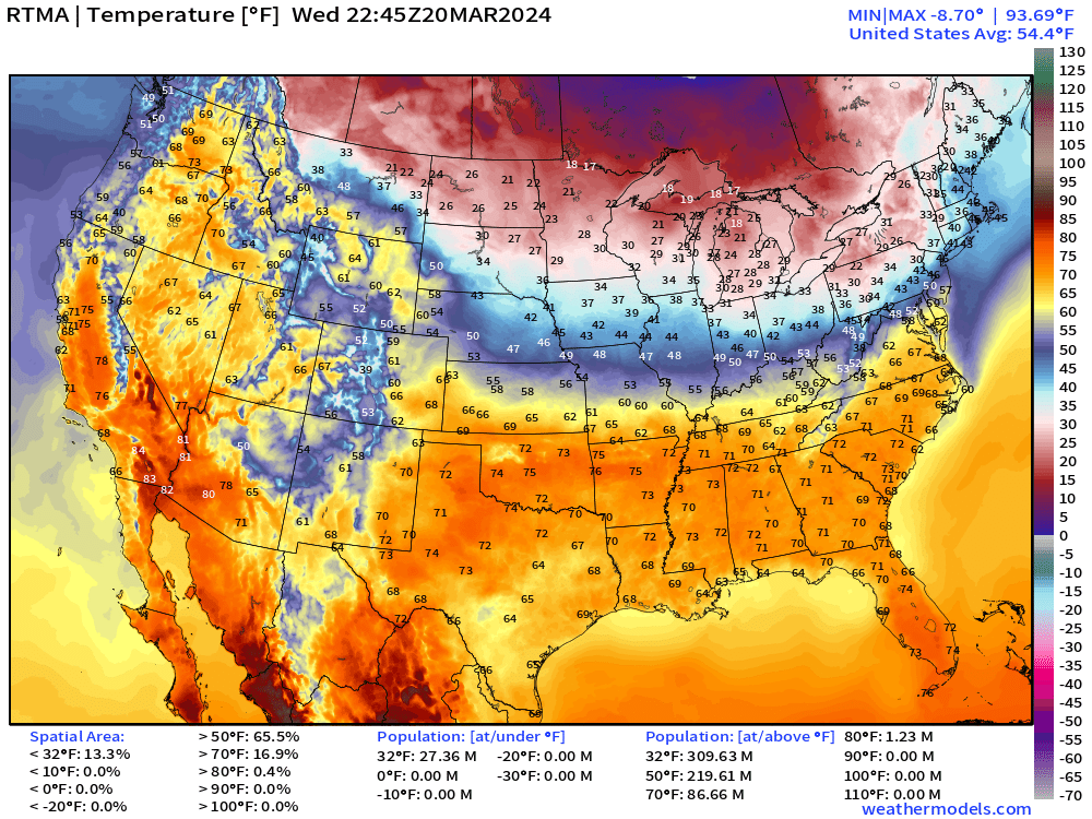
6:45 PM ET Temperature Analysis: after a chilly morning in the Southeast, temperatures warmed up nicely into the 70s into Nashville! Nice and warm in California again pushing 80°F in the Central Valley. Unfortunately, that’s not sticking around for much longer.
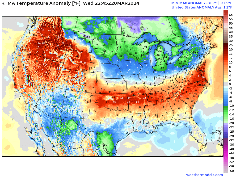
Temperature Anomaly: Unusual pattern with above normal temperatures centered along Interstate 40 from DelMarVa to OKC, sandwiched in between below normal — especially much below in the Midwest and Great Lakes where it’s snowing — and the Gulf Coast, which was in the 30s this morning. That cooler and very dry air moderated in the March Spring sunshine.
Thursday Morning Low Temperatures
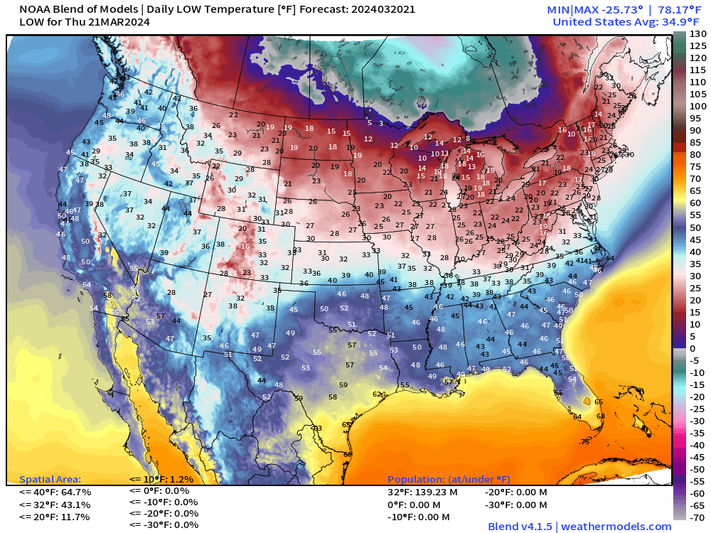
Cold in the Great Lakes, Northeast, and Midwest with 10s and 20s °F & mid-40s in Atlanta down to Ocala. I see as cold as -25°F in Canada!
Thursday High Temperatures
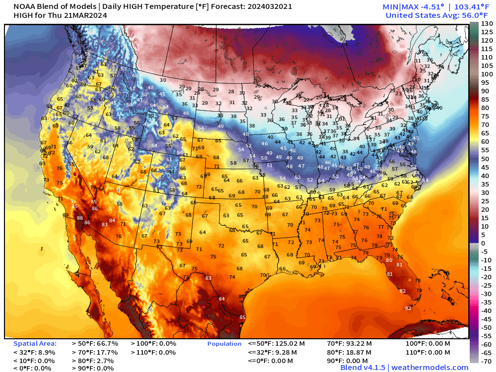
Another beautiful and mild spring day across the southern U.S. with 70s lining up from the Nashville southward into Florida, where it’s warmer in the 80s. Seeing upper-80s pop up in the Southwest around Yuma with Phoenix in the mid-80s. Comfortable in Salt Lake City in the 60s.
Still chilly across the Midwest and Great Lakes in the 30s for highs in Minneapolis to Milwaukee and Detroit.
Snowfall Next 78-Hours
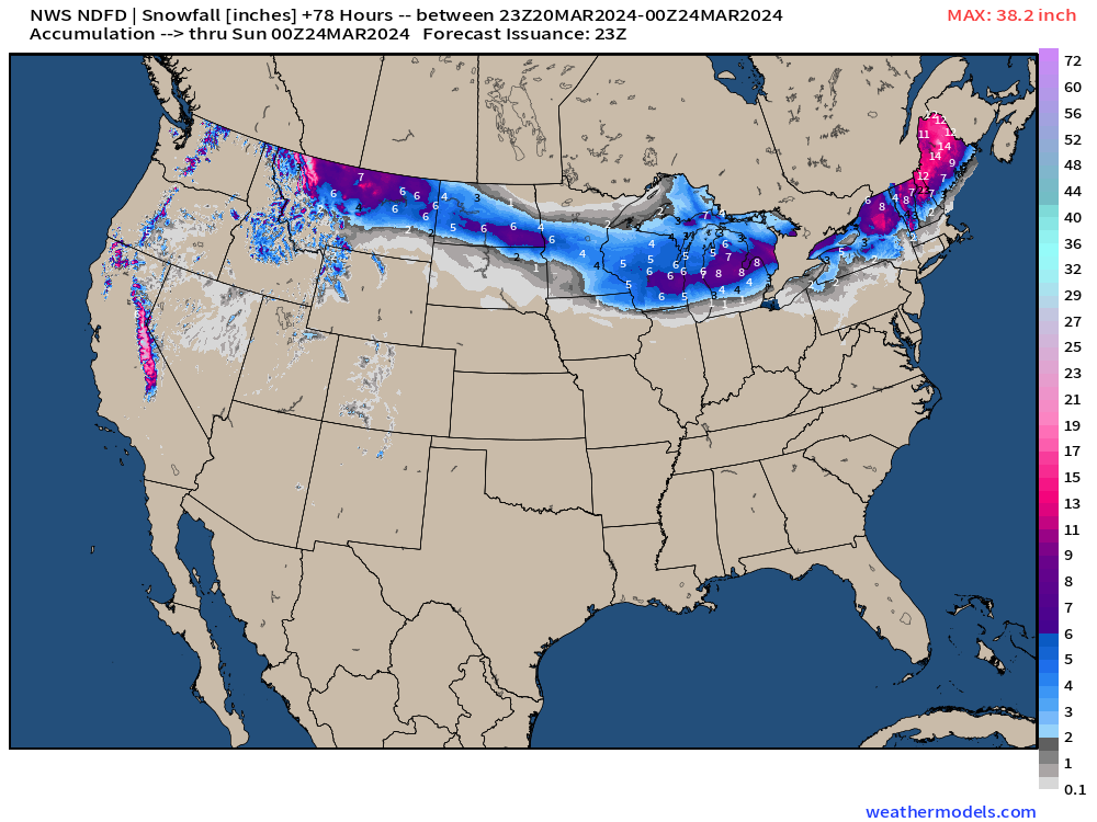
The storm in New England really dumps the snowfall on Maine — 12-18”+ in the next 3-days, before the next system could double that! That system skirts along the northern tier from Montana into Michigan into Friday.
California Sierra back to heavy snowfall, too.
Florida Deluge Next 3-Days
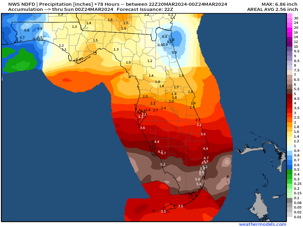
Whoa! The rainfall expected in South Florida is now up to 6” including Miami. This is the southern component of the powerful winter storm that drenches the eastern seaboard into New England before turning to heavy snow again in Maine.
Next 8-days Weather Pattern: Several Storm Systems
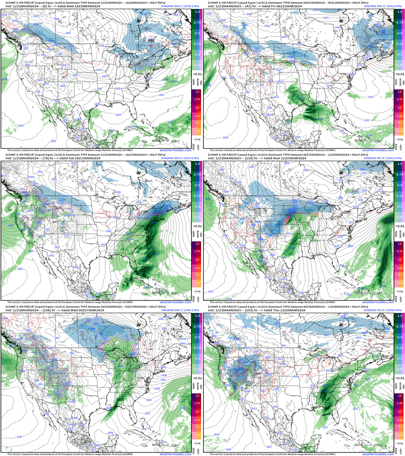
Thursday: Clipper system over Northeast and Maritime Canada deepens with significant snowfall in Maine: 12”-18”!
Friday into Saturday: area of low pressure skirts along Gulf Coast = heavy rain for Florida, up to 6” developing further as it phases with upper-levels
Saturday into Monday: This East Coast low develops and intensifies with heavy rain in Mid-Atlantic and Northeast, and heavy snow again in northern New England.
Monday: Powerful central plains into Midwest winter storm still in the forecast!
Next Thursday: West unsettled again with boatloads of Pacific moisture arriving within a very chilly trough/ weather pattern.
Blend of Models: 10 Day Snowfall Forecast
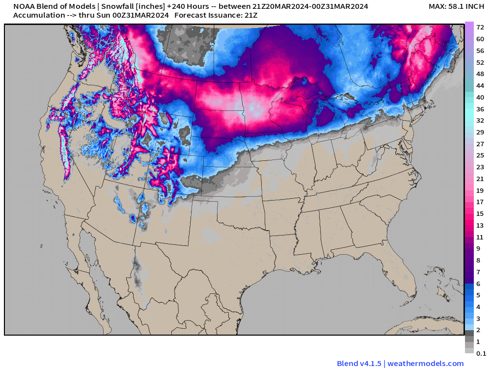
[The Blend of Models is a collection of major global weather models and their ensembles so it is typically rather smooth. But not the upcoming 10-day forecast!]
That is over 30” centered upon Minnesota with a large area of more than 1-foot of snowfall accumulations across the Midwest into the Great Lakes. Amazing map during the last 10-days of March. Add to that Maine with 2-feet.
And, then the Rockies + Sierra load up more snow pack. This is an amazing end to March 2024.
WPC 7-Day Precipitation Forecast
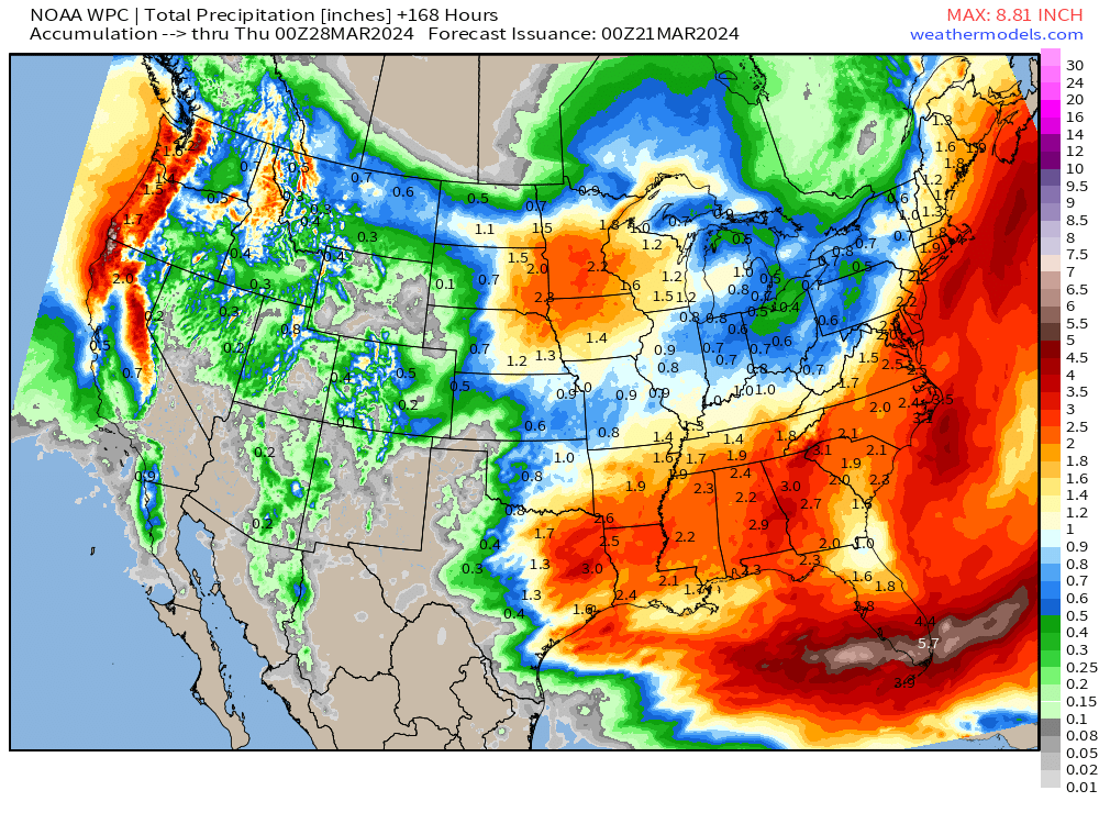
The next week will also be quite wet with this progressive / busy weather pattern.
2.2” of QPF in Minneapolis to fall mostly as snowfall. Large area of 2”+ from East Texas into Atlanta (3”) and 1-3” up the east coast.
5.7” smack on top of Miami!
Ensemble Median Snowfall 15-Days
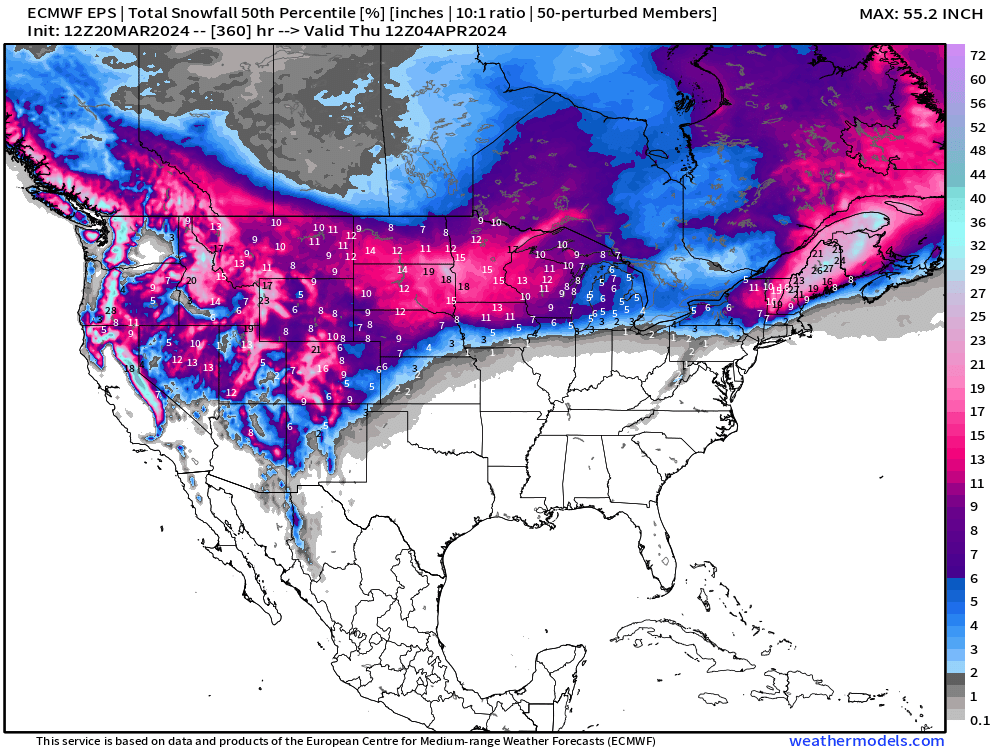
I have just enough email space leftover to show the 15-day median snowfall map. Wow! This goes until April 4th.
Thank you to Subscribers and Supporters! Almost Spring 2024 and the growing season — so much is going on in the world of weather! Please come along for the ride!
Maps sourced from weathermodels.com
- Milepost
- 241 · laid 2024-03-20T23:55:35.323000Z
- Source
- https://weather.substack.com/p/march-20-2024-evening-update
- Digest
- 3395232f5ea1721bfc3a6d0cf4eb0d588c9a3ce9db1afd9b0e2f75609b047235
- Machine
- JSON