March 18, 2024 Snowfall back in Forecast for Midwest
Colder pattern by this weekend across Western U.S.
March 2024 was the 21st-warmest March in the 132-year national record (1895–2026), at 44.9°F against a 1991–2020 normal of 43.6°F (+1.4°F).
March 2024 was the 29th-wettest March in the 132-year national record (1895–2026), at 2.9in against a 1991–2020 normal of 2.5in (+0.4in).
NOAA/NCEI Climate at a Glance, contiguous United States. This is the observed record for the month, not a score of anything said in this piece — the forecast ledger begins 2026-08-17 and cannot reach earlier posts.

Tuesday morning frost freeze into the Southeast — “false spring?”
Clipper Systems across Midwest and Great Lakes with minor snow accumulations
Day 7 [next Monday] East Coast Hybrid or Subtropical Low Pressure system
Central U.S. powerful storm with potential for significant snowfall. Any precipitation is welcome across the central and northern Plains
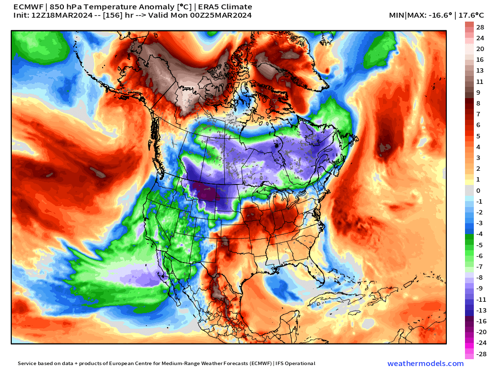
Colder air across Western U.S. by Days 8-10
15-Day Ensemble Snowfall is lit up like mid-Winter
Tuesday Morning Low Temperatures
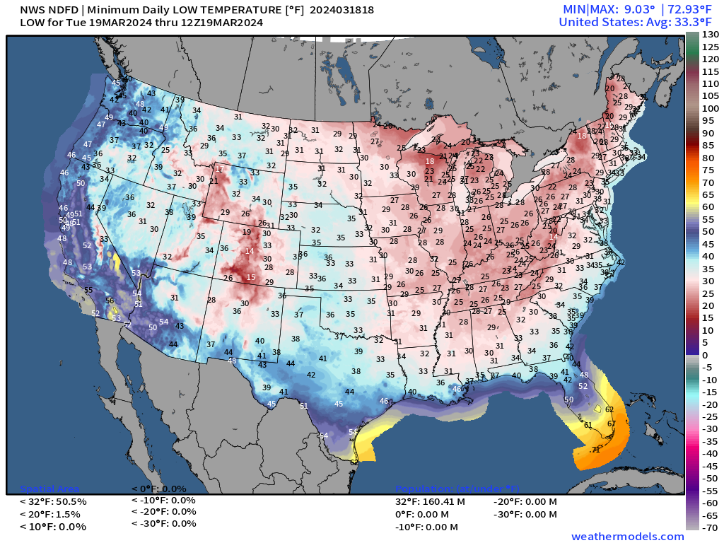
Temperatures in the 20s and 30s — below freezing extend to about Macon Georgia and then across to Montgomery and Birmingham.
30s also in the Florida panhandle — could be near freezing briefly in before sunrise.
Make sure to cover up your tender vegetation completely. This is only a one-day event, so hopefully no lasting damage.
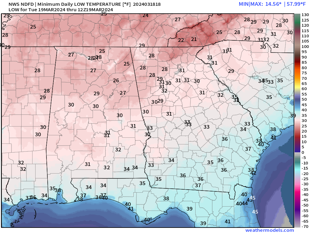
False Spring
If trees, vegetation, or other plants bud or flower early e.g. fruit trees in late February or early March due to persistent warmth, then there’s a significant risk of damage when a major killing freeze comes along in late March or early April.
There is voluminous research over the past decade about how climate change will impact the frequency of “false spring” events. On balance, if the midlatitudes continue to warm significantly, then there is less probability for a late killing freeze. The greening or budding early will change less so this asymmetry will yield fewer false spring events in the coming decades. The worst “False Spring” on record was in 1827-28 when the winter was extremely mild. Here is a nice academic article that is easy to read on the historical event.
Cherry blossoms in D.C. made the news on Sunday with very early peak bloom. This is jointly due to the warm El Nino winter, long-term global warming, and the urbanization or land use change.
Tuesday High Temperatures
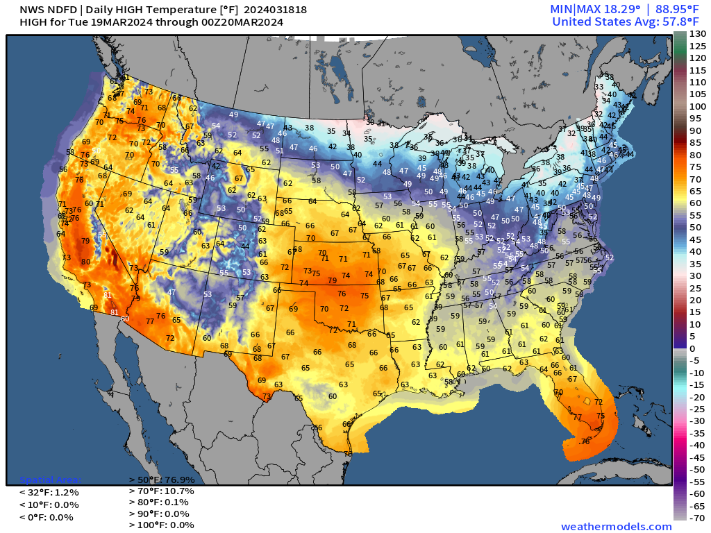
Nice and warm across the central Plains in the 70s. Very nice spring weather along the entire West Coast from Los Angeles to Portland and Seattle. Well deserved especially after this cool, unsettled and very wet (or snowy) winter.
Only 1% of the Lower 48 fails to reach freezing for high temperatures on Tuesday. We are turning the corner on the Spring season — sort of — until we backtrack for the next 7-10 days heading into April. A cooler pattern is on the way with air masses from Canada and the North Pole bringing the putative “polar vortex” into the Midwest and Great Lakes.
Clipper Systems
From the ECMWF 10-day HRES forecast, the weather pattern is quite active with moisture from the Pacific combining with the polar front to provide a series of snowfall accumulation chances over the next 10-days mainly north of Interstate 80.
The initial clipper systems over the next 2-3 days will be enough — with Lake Effect enhancement — to drop a few inches of snow along the lakeshores. Could be 3-6” in the favored snowbelts. However, daytime temperatures should be warm enough to mitigate any serious impacts — so nighttime black ice and slippery roads remains the major threat.
By Next Monday - Tuesday, a major storm develops over the Rockies and tracks into the Midwest and Great Lakes.
Too soon to determine the exact track or character of the storm system, but it could have significant snowfall for Minneapolis or Chicago (or neither).
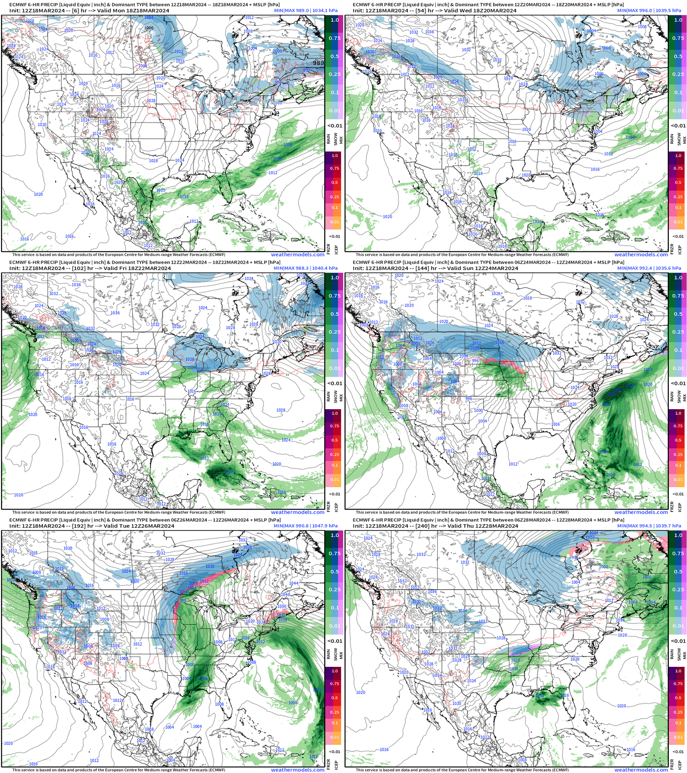
Colder Canadian Arctic Air Masses Continue in Waves
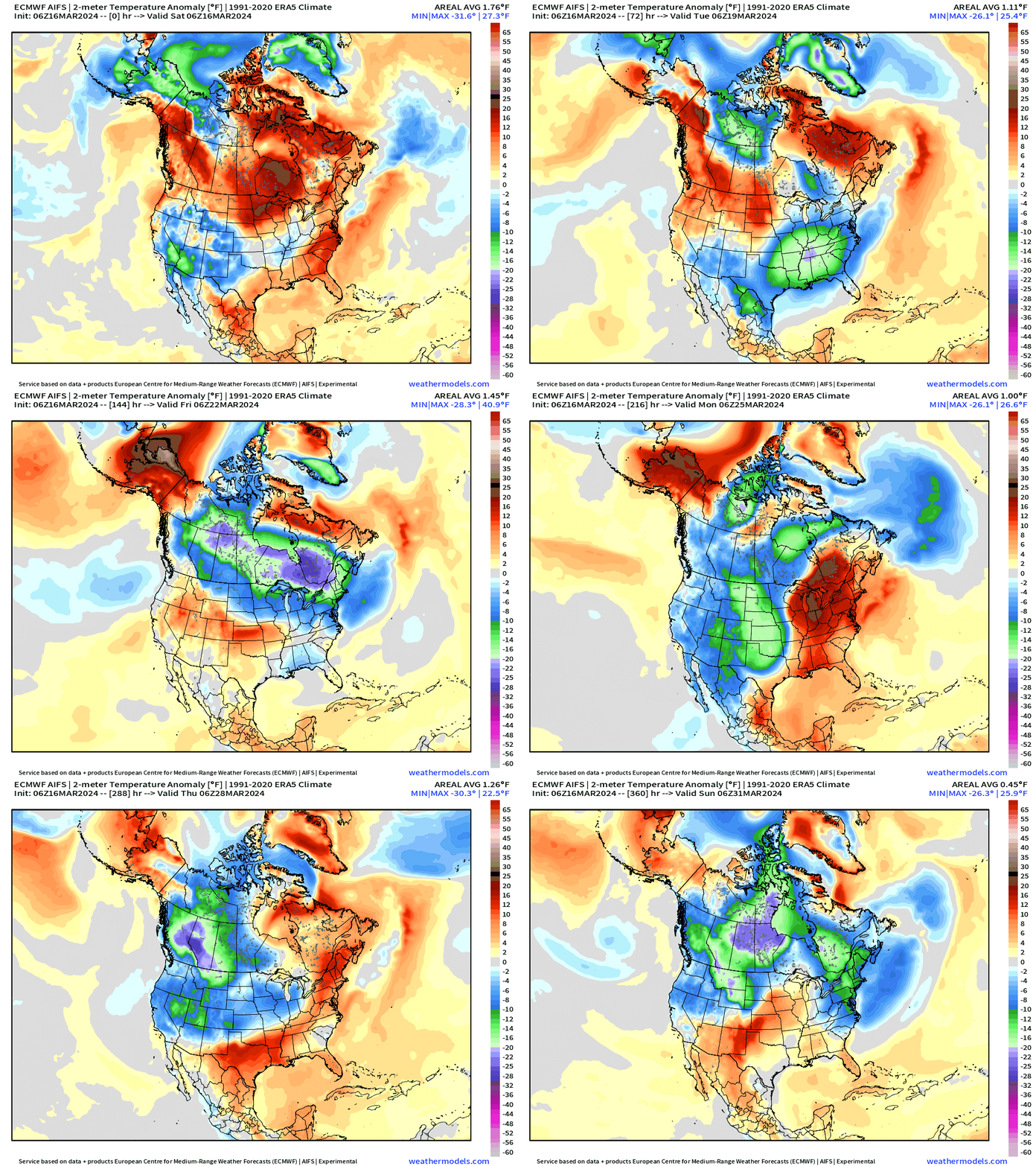
The upper-level pattern favors influence of Canadian troughs keeping the northern tier on average with cooler than normal temperatures. An active storm track for late March will provide numerous precipitation chances with frontal passages across the Lower 48, so plenty of cloud cover. Hopefully this type of weather pattern does not set up shop in mid-April for the solar eclipse.
East Coast Storm Next Monday
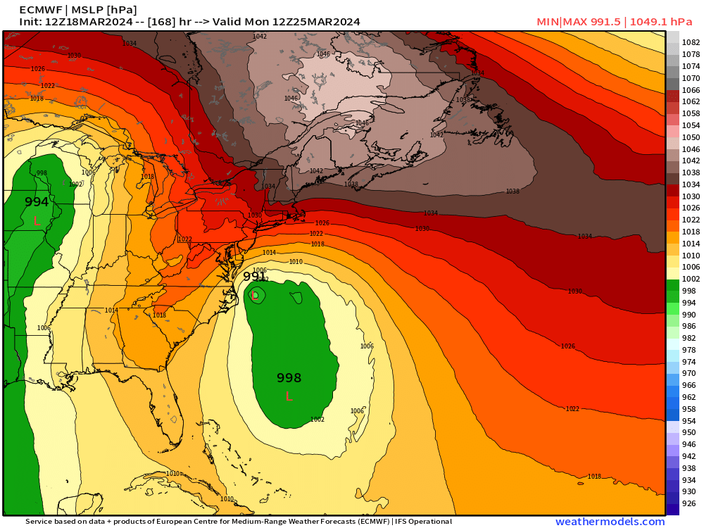
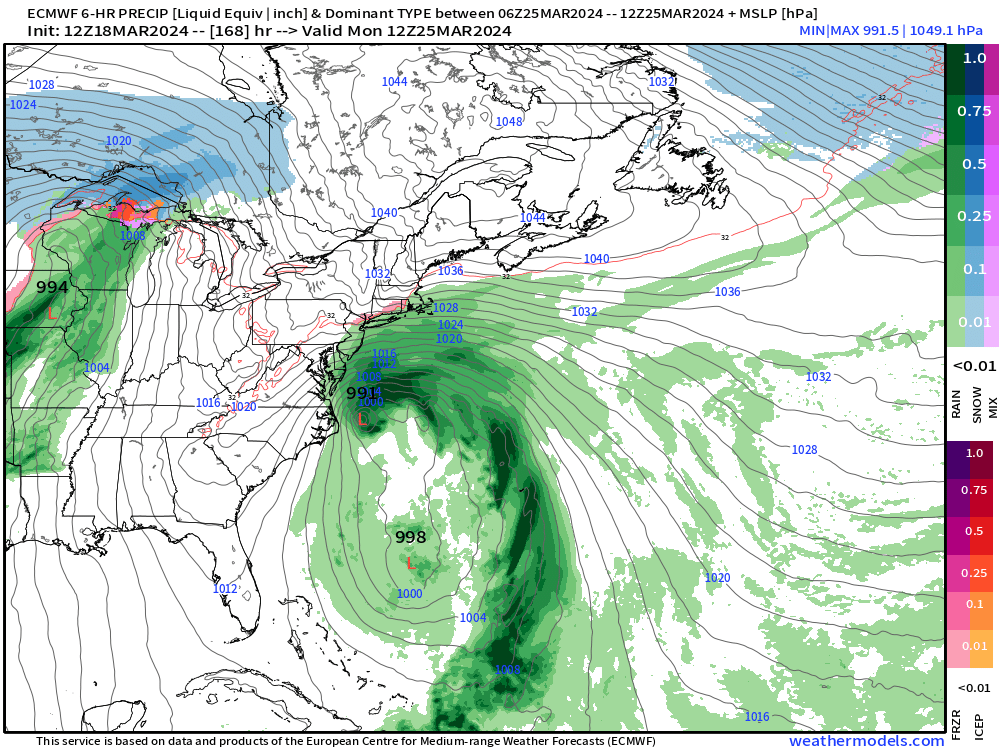
A blocking ridge will provide an interesting opportunity for a subtropical storm to develop off the East Coast over the warm Gulf Stream waters.
7-Day Rainfall Total | NWS WPC
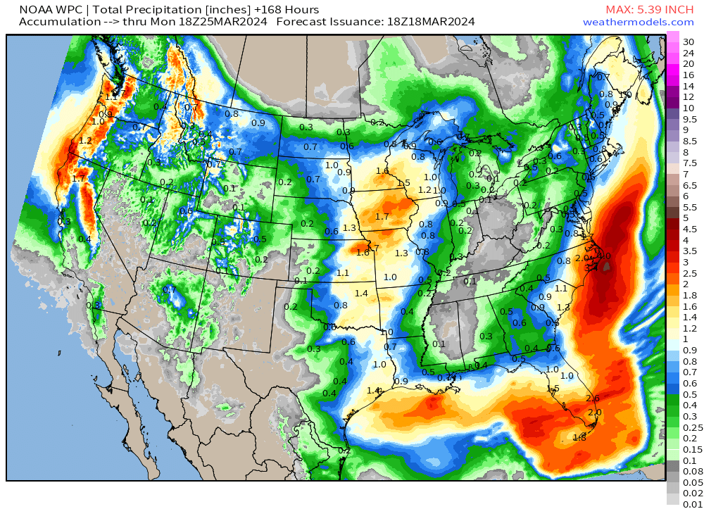
We need the rainfall in Iowa — so this 7-day forecast is encouraging. Some of the precipitation on the northern side of this will be snowfall — good too.
15-Day Ensemble Snowfall
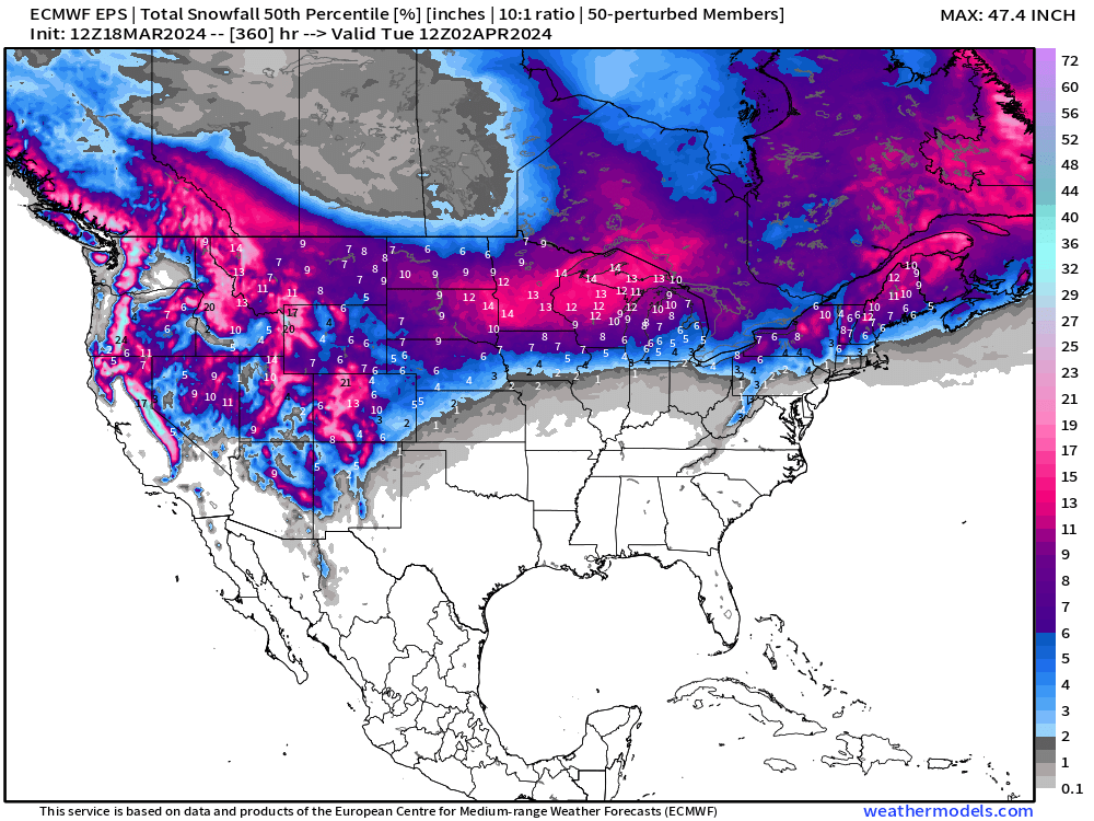
This map looks ominous but it’s 15-days of a very active weather pattern working with an inch or so of QPF. And, 1-inch of QPF is about 10-12 inches of snowfall.
The ensemble median is sorting the various storm track options early next week when enough cold air is in place for significant accumulations.
The western U.S. transitions to much colder airmass, which continues winter full-tilt into April. This ongoing period of warmth will come to an end Sun-Mon behind the powerful early Spring storm system. This storm system will have a powerful warm front and could be a severe weather threat.
Thank you to Subscribers and Supporters! Almost Spring 2024 and the growing season — so much is going on in the world of weather! Please come along for the ride!
- Milepost
- 238 · laid 2024-03-18T19:44:30.123000Z
- Source
- https://weather.substack.com/p/march-18-2024-snowfall-back-in-forecast
- Digest
- 61d94e02097d31b3983b38c3e91387af0a4d4d693af9ca3625469a42408051cb
- Machine
- JSON