January 12, 2024 Polar Plunge
Pool of extreme cold Canadian air descends into Lower 48
January 2024 was the 46th-warmest January in the 132-year national record (1895–2026), at 31.9°F against a 1991–2020 normal of 32.3°F (-0.5°F).
January 2024 was the 7th-wettest January in the 132-year national record (1895–2026), at 3.3in against a 1991–2020 normal of 2.3in (+0.9in).
NOAA/NCEI Climate at a Glance, contiguous United States. This is the observed record for the month, not a score of anything said in this piece — the forecast ledger begins 2026-08-17 and cannot reach earlier posts.
Temperatures of -50°F in Edmonton, Alberta, Canada earlier on Friday will get even colder Saturday morning for potential of coldest since records began at the airport in 1959. The mark to beat is from January 25-26, 1972 and in the minus-50s. That cold air is descending into Montana with NWS forecasts around -60°F for Saturday’s coldest. We’ll monitor the rural weather stations since the mountainous areas where the coldest temperatures will occur are sparsely populated.
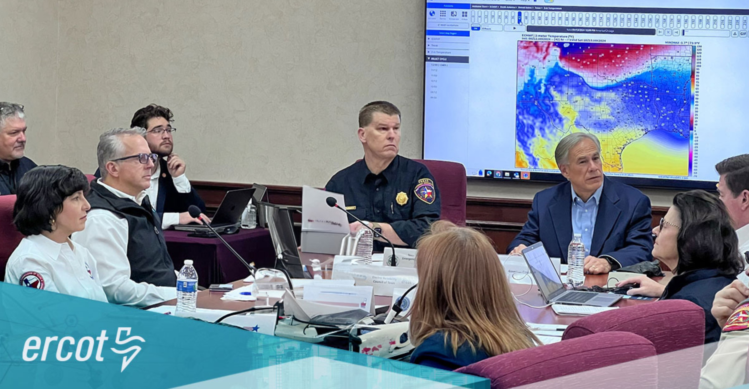
Texas Governor Greg Abbott held a little confab briefing with ERCOT to ensure Texans that all hell won’t break loose like in February 2021’s “Deep Freeze”. Good news is that the state was prepared with a test run during late December 2022 and everything held up. The incoming cold blast is not as severe as 2021 but long lasting. However, the lack of wintry precipitation should keep electricity on.
Abbott was sitting in front of a WeatherModels temperature map from the ECMWF 00z run. Good idea!
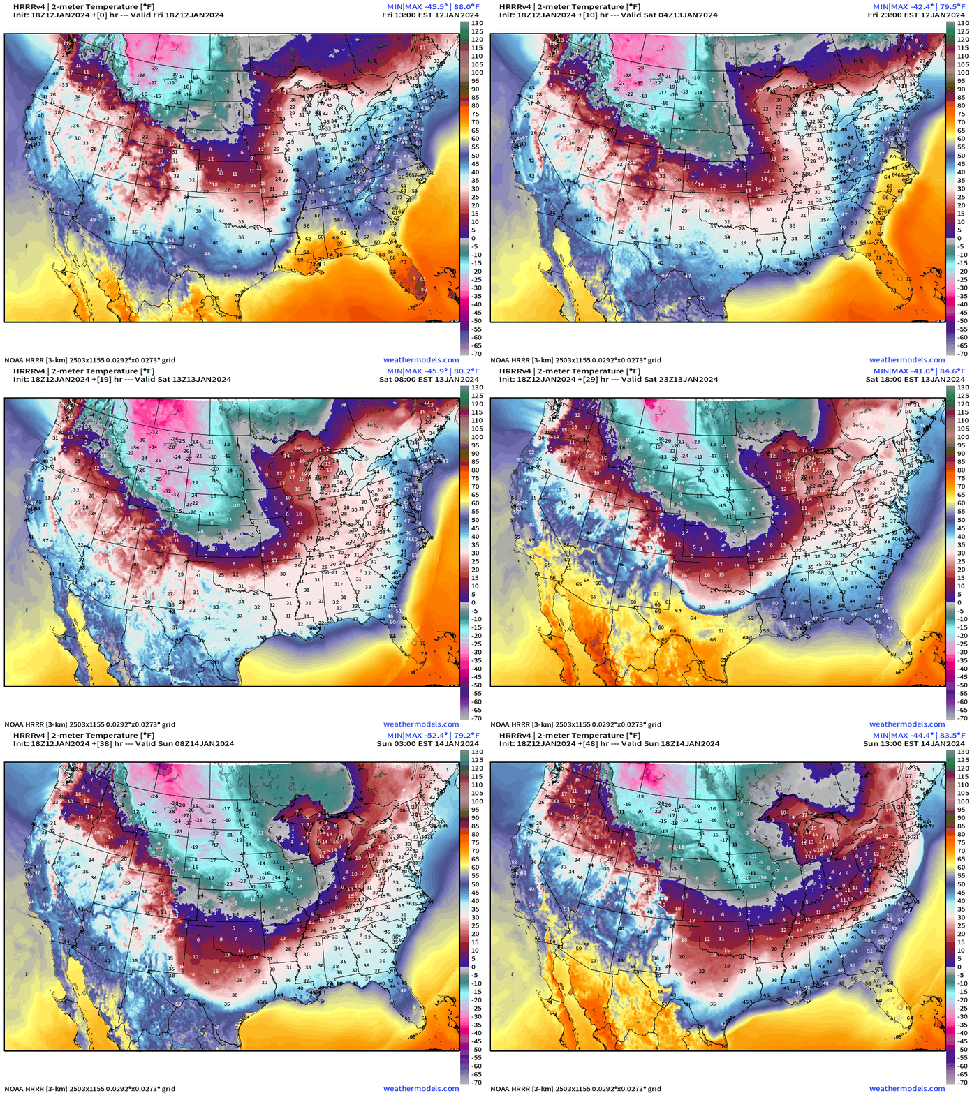
The HRRR mesoscale model shows the descent of the cold pool into Texas by Sunday morning before a little warmup during the day. Then the bottom drops out again.
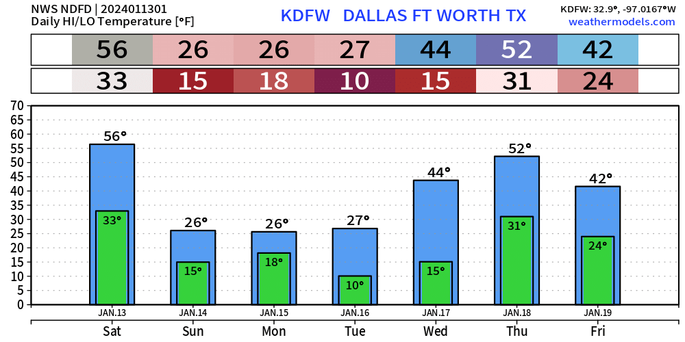
Dallas coldest should be around 10°F Tuesday morning with up to 72-hours of subfreezing temperatures.
An atmospheric river will bring plenty of snowfall to the higher elevations of the Oregon, California, Idaho, Utah, and Colorado over the next 3-days. The skiers and snowboarders will have so much snow!
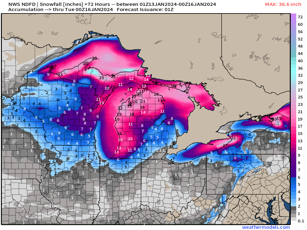
The Great Lakes will see 1-3 feet in the Lake Effect snow belts. Not sure the folks in Arkansas will like the 6-8 inches of snowfall extending into Nashville. The snow might linger for a while until late next week when temperatures warm up above freezing. The extra snow cover will help maintain the cold pool.
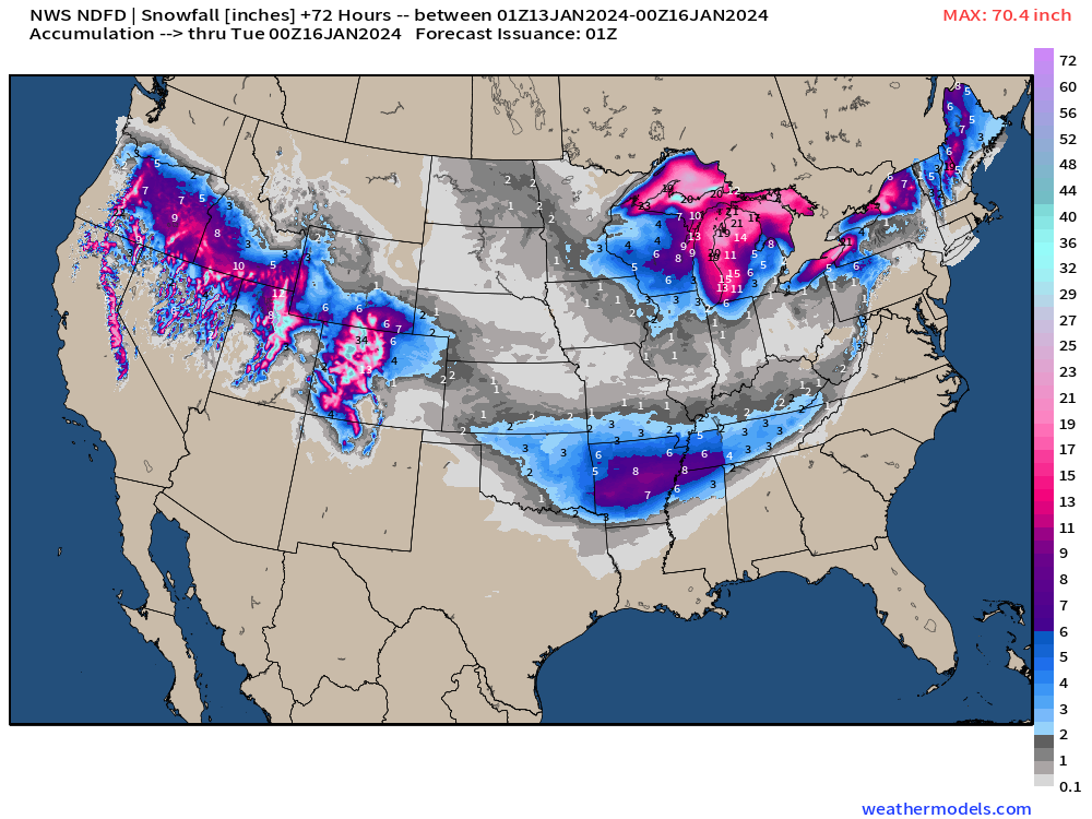
NWS has 36-inches+ for the Michigan Upper Peninsula shoreline. 1-2 feet along the Lake Michigan shoreline from Benton Harbor to the Bridge. Buffalo with 18-21” and then more up into the Tug Hill plateau. Nothing unusual for mid-January except for 2 NFL Wild Card games in extremely wintry conditions!
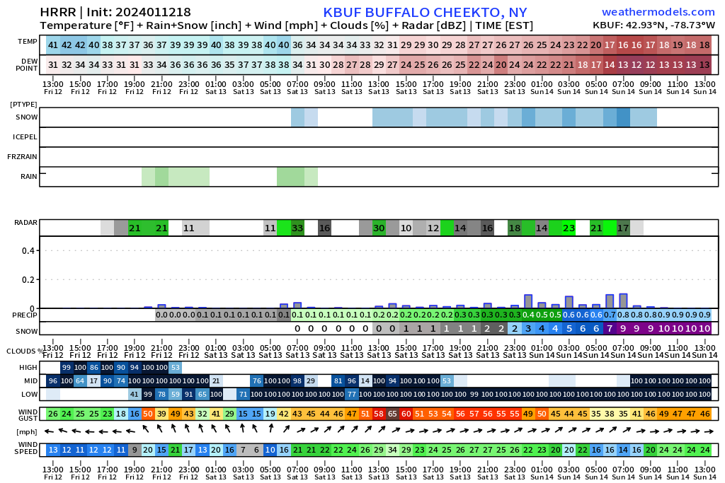
Pittsburgh Steelers vs. Buffalo Bills 1 PM ET on Sunday
WSW winds gusting from 40-50 mph+
Up to 10-16” of snowfall and temperatures in the 20s. The game starts right at the end of the meteogram, so the Lake Effect snow band could be moved out of the area by a few miles, or not! [Over/Under 33.5]
Kansas City Chiefs vs. Miami Dolphins Saturday evening 8 PM ET at Arrowhead
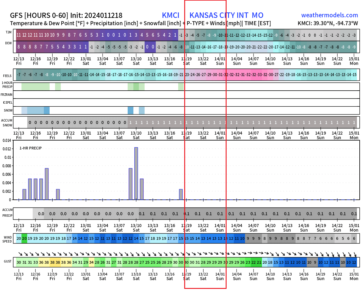
Temperatures for this game will plummet below zero from -3°F to -10°F by midnight EST. Winds out of the NW will be gusty to around 30 mph and lead to wind chills into the minus 20s and minus 30s °F. [The Over/Under is 43.5 points.]
Blend of Models Forecasts
Arctic Blast
Sunday Low Temperatures | January 14, 2024
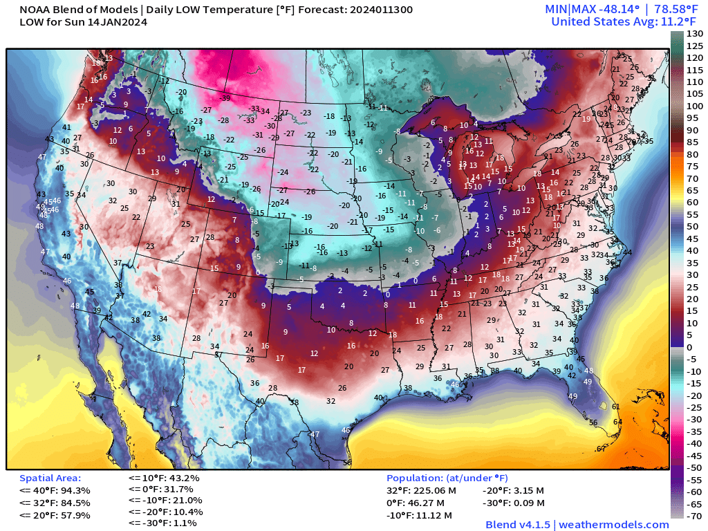
Look at that enormous cold pool stretching into central Texas by Sunday morning and east to the Ohio Valley and Nashville. Almost 1/3 of the Lower 48 at/below 0°F and 85°F at/below freezing. This Arctic blast is weighted to the central U.S. and the worst of it will not keep its intensity to the Mid-Atlantic or Northeast like the 2014 Polar Vortex that swung through the Midwest and Great Lakes.
Monday Low Temperatures | January 15, 2024
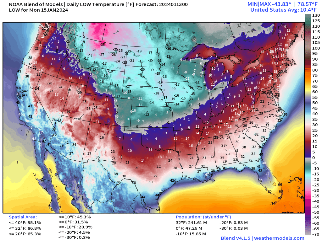
Lower 48 average temperature down to 10°F. The single digits make it to North Texas. The only warmth hanging on in South Florida in the 60s.
Iowa Caucus will be starting out in the minus teens to minus 20s °F but warm to -3°F or -4°F.
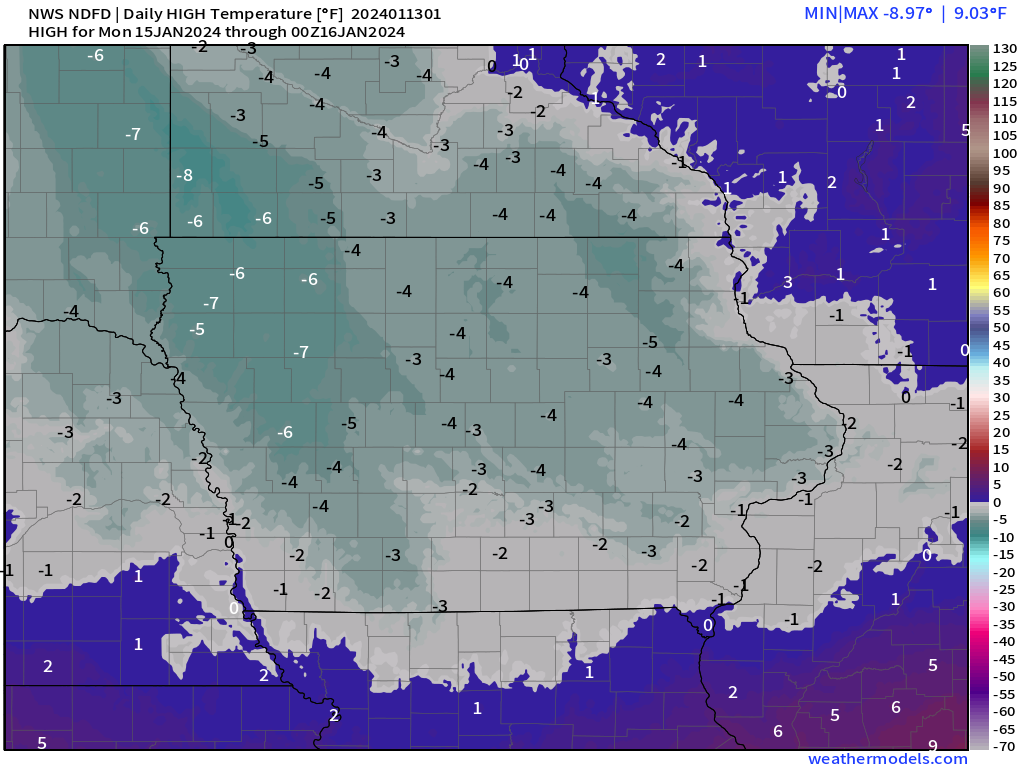
Tuesday Low Temperatures | January 16, 2024
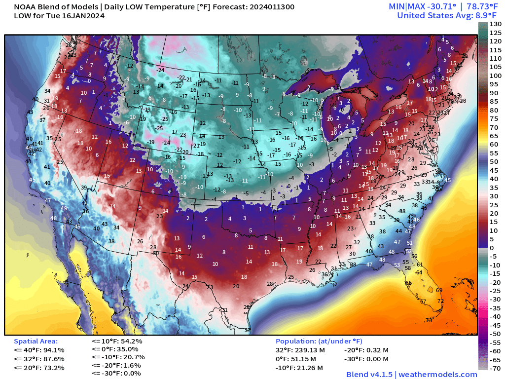
8.9°F Lower 48 average temperature. 88% of the Lower 48 is below freezing.
The Blend of Models in the 7-day + range uses the various global models and ensembles to build temperature forecasts out to 10-days.
Temperature Outlook Next 2-Weeks
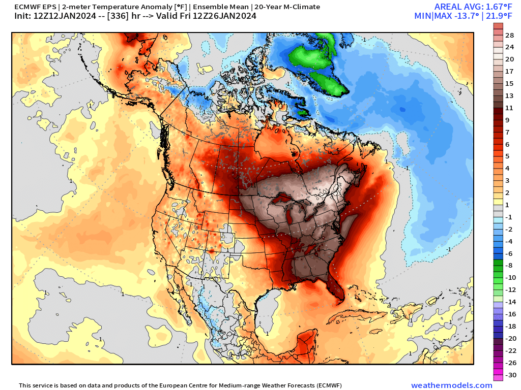
Warming trend incoming! Week 2 with above normal temperatures across a huge swath of North America. Whew — we’ll be happy for that!
Week 1: January 12 - January 19, 2024 [EPS Mean 12z]
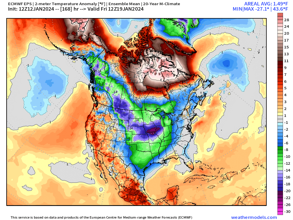
Week 2: January 19 - January 26, 2024 [EPS Mean 12z]
Snowfall Forecast 10-day EPS Median
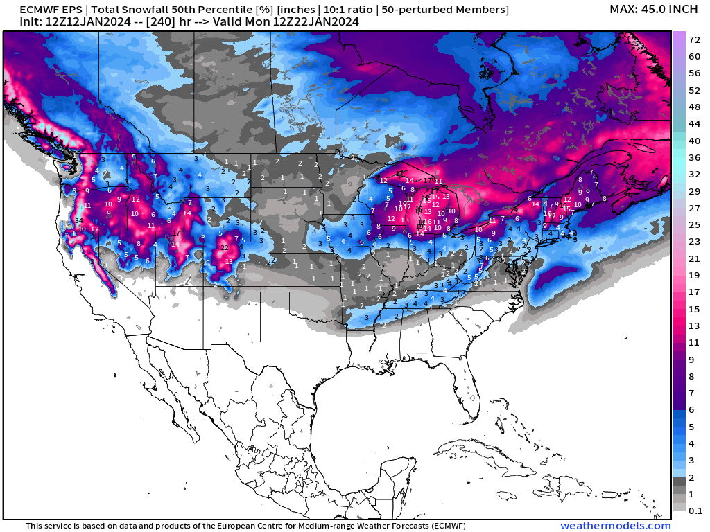
The best chance of snowfall along the East Coast is Tues/Wed from a potential coastal storm. The models haven’t nailed down the details as of yet. More on that tomorrow.
Plenty of additional Western U.S. snowfall.
All maps are probably from weathermodels.com (please subscribe there for affordable, professional, and beautiful weather maps created by yours truly).
Thank you to my paying and freemium subscribers!
Your support pays for my Linux servers and product development. Also, it allows me to provide (usually) interesting and valuable commentary on scientific topics on X. Feel free to say hello and follow on X/Twitter (@RyanMaue)
Old News:
This newsletter will rebrand in 2024 as part of roll out of [WT] https://weathertrader.com
- Milepost
- 181 · laid 2024-01-13T03:01:14.373000Z
- Source
- https://weather.substack.com/p/january-12-2024-polar-plunge
- Digest
- 8962adfa9025d8ad1fd1607d5fa0069289fdb792d99b2b0a332e1e291f1c6e16
- Machine
- JSON